
Maryland Route 176
Encyclopedia
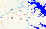
Maryland Route 176 is an east–west route in Anne Arundel County
.
. Continuing east it intersects the northern end of MD 713
north of that route's interchange with MD 100
, itself north and east of Arundel Mills Mall. The route continues onward through suburban neighborhoods towards the southwestern corner of BWI Airport, intersecting MD 170
in Harmans
. East of this intersection, it becomes part of the Airport Loop
.
After intersecting MD 652, an unsigned segment of Old Telegraph Rd., the route continues along the southern boundary of BWI, eventually reaching the northern edge of Friendship Park, which contains a parking lot and observation stands, allowing people to watch planes land at the nearby runway. Continuing east, MD 176 intersects the southern terminus of MD 162
; the Airport Loop designation turns onto MD 162, while MD 176 continues onward to interchange with Interstate 97
just north of the latter's interchange with MD 100
.
Beyond I-97, the route skirts the northern edge of Saw Mill Creek Park before passing the southern terminus of a light rail line and terminating at MD 648
, just short of MD 2
and MD 3 Business
in Glen Burnie
.
in Elkridge, Route 176, also known as Dorsey Road, has been truncated by Maryland Route 100
; Route 176's cloverleaf
with Maryland Route 295 was reused by MD 100
.
Dorsey Road itself has been cut into two segments. While the eastern segment remains part of MD 176, the western segment from U.S. 1
to Coca Cola Drive was renumbered 103
in an extension of that route from Howard County
. MD 103's section of Dorsey Road now terminates at local neighborhood streets just past Coca-Cola Drive on the south side of MD 100
.
Anne Arundel County, Maryland
Anne Arundel County is a county located in the U.S. state of Maryland. It is named for Anne Arundell , a member of the ancient family of Arundells in Cornwall, England and the wife of Cæcilius Calvert, 2nd Baron Baltimore. Its county seat is Annapolis, which is also the capital of the state...
.
Route description
MD 176 begins at a cul-de-sac near Wright Rd., a local neighborhood street, within sight of its old interchange with MD 295, now used by MD 100Maryland Route 100
Maryland Route 100 is a major east–west highway connecting U.S. Route 29 in Ellicott City and MD 177 in Pasadena. MD 100 also connects to Interstate 95 , US 1, the Baltimore-Washington Parkway , and I-97...
. Continuing east it intersects the northern end of MD 713
Maryland Route 713
Maryland Route 713 is a state highway in the U.S. state of Maryland. The state highway runs from an entrance to Fort George G. Meade north to MD 176 in Hanover. In addition to serving as an access point to the U.S...
north of that route's interchange with MD 100
Maryland Route 100
Maryland Route 100 is a major east–west highway connecting U.S. Route 29 in Ellicott City and MD 177 in Pasadena. MD 100 also connects to Interstate 95 , US 1, the Baltimore-Washington Parkway , and I-97...
, itself north and east of Arundel Mills Mall. The route continues onward through suburban neighborhoods towards the southwestern corner of BWI Airport, intersecting MD 170
Maryland Route 170
Maryland Route 170 is a roughly 13-mile-long road in Anne Arundel County.-Route description:MD 170 begins at the intersection of MD 175 Annapolis Road and Piney Orchard Parkway, in Odenton. It runs north towards Severn, interchanging with MD 32 northwest of the town...
in Harmans
Harmans, Maryland
Harmans is an unincorporated community in Anne Arundel County, Maryland, United States....
. East of this intersection, it becomes part of the Airport Loop
Airport Loop
Airport Loop is the designation for the portions of state highways that form a circumferential highway around Baltimore/Washington International Thurgood Marshall Airport in Anne Arundel County in the U.S. state of Maryland. The loop runs through the communities of Linthicum, Ferndale, and Hanover...
.
After intersecting MD 652, an unsigned segment of Old Telegraph Rd., the route continues along the southern boundary of BWI, eventually reaching the northern edge of Friendship Park, which contains a parking lot and observation stands, allowing people to watch planes land at the nearby runway. Continuing east, MD 176 intersects the southern terminus of MD 162
Maryland Route 162
Maryland Route 162 forms the eastern part of the Airport Loop around Baltimore-Washington International Thurgood Marshall Airport designated as Aviation Boulevard. It is long and Links Telegraph and Camp Meade Road with North Dorsey Road . Maryland Route 162 also provides access to Interstate 97...
; the Airport Loop designation turns onto MD 162, while MD 176 continues onward to interchange with Interstate 97
Interstate 97
Interstate 97 is an intrastate Interstate Highway located entirely within Anne Arundel County, Maryland, United States. It runs from Annapolis at the overlapped section of US 50, US 301, and the unsigned I-595 to Baltimore at the city's beltway...
just north of the latter's interchange with MD 100
Maryland Route 100
Maryland Route 100 is a major east–west highway connecting U.S. Route 29 in Ellicott City and MD 177 in Pasadena. MD 100 also connects to Interstate 95 , US 1, the Baltimore-Washington Parkway , and I-97...
.
Beyond I-97, the route skirts the northern edge of Saw Mill Creek Park before passing the southern terminus of a light rail line and terminating at MD 648
Maryland Route 648
Maryland Route 648 is a collection of state highways in the U.S. state of Maryland. These highways are sections of Baltimore–Annapolis Boulevard, the old alignment of MD 2 between Annapolis and Glen Burnie. These segments were bypassed when MD 2 was moved to Governor Ritchie Highway, a...
, just short of MD 2
Maryland Route 2
Maryland Route 2 is the longest state highway in the U.S. state of Maryland. The route runs from Solomons Island in Calvert County north to an intersection with U.S. Route 1 and U.S. Route 40 Truck in Baltimore...
and MD 3 Business
Maryland Route 3
Maryland Route 3, also part of Robert Crain Highway, is the designation given to the former alignment of U.S. Route 301 from Bowie, Maryland, USA, to Baltimore. It is named for Robert Crain of Baltimore.-Route description:...
in Glen Burnie
Glen Burnie, Maryland
Glen Burnie is a census-designated place in Anne Arundel County, Maryland, United States, and is a suburb of Baltimore. The population was 67,639 at the 2010 census...
.
Junction list
| Location | Mile | Destinations | Notes |
|---|---|---|---|
| 0.00 | Wright Road | Western terminus | |
| Hanover Hanover, Maryland Hanover, Maryland is a locality in unincorporated northwestern Anne Arundel County, Maryland in the United States, located south of Baltimore near the Howard County line.... |
0.9 | , Patapsco Valley State Park Patapsco Valley State Park Patapsco Valley State Park is located in Maryland, USA and extends along 32 miles of the Patapsco River, encompassing and five developed recreational areas. Recreational opportunities include hiking, fishing, camping, canoeing, horseback riding and mountain bike trails, as well as picnicking for... |
|
| Harmans Harmans, Maryland Harmans is an unincorporated community in Anne Arundel County, Maryland, United States.... |
2.1 | MD 170 north of MD 176 is part of Airport Loop Airport Loop Airport Loop is the designation for the portions of state highways that form a circumferential highway around Baltimore/Washington International Thurgood Marshall Airport in Anne Arundel County in the U.S. state of Maryland. The loop runs through the communities of Linthicum, Ferndale, and Hanover... |
|
| MD 176 joins the Airport Loop Airport Loop Airport Loop is the designation for the portions of state highways that form a circumferential highway around Baltimore/Washington International Thurgood Marshall Airport in Anne Arundel County in the U.S. state of Maryland. The loop runs through the communities of Linthicum, Ferndale, and Hanover... |
|||
| 2.7 | Former MD 170 | ||
| McPherson | |||
| 4.7 |  Maryland Route 162 Maryland Route 162 forms the eastern part of the Airport Loop around Baltimore-Washington International Thurgood Marshall Airport designated as Aviation Boulevard. It is long and Links Telegraph and Camp Meade Road with North Dorsey Road . Maryland Route 162 also provides access to Interstate 97... north (Aviation Boulevard / Airport Loop Airport Loop Airport Loop is the designation for the portions of state highways that form a circumferential highway around Baltimore/Washington International Thurgood Marshall Airport in Anne Arundel County in the U.S. state of Maryland. The loop runs through the communities of Linthicum, Ferndale, and Hanover... ) – Linthicum Linthicum, Maryland Linthicum is a census-designated place and an unincorporated community in Anne Arundel County, Maryland, United States. The population was 7,539 at the 2000 census. It is the approximate location of Baltimore-Washington International Thurgood Marshall Airport... |
Former MD 167 | |
| MD 176 separates from the Airport Loop Airport Loop Airport Loop is the designation for the portions of state highways that form a circumferential highway around Baltimore/Washington International Thurgood Marshall Airport in Anne Arundel County in the U.S. state of Maryland. The loop runs through the communities of Linthicum, Ferndale, and Hanover... |
|||
| Glen Burnie Glen Burnie, Maryland Glen Burnie is a census-designated place in Anne Arundel County, Maryland, United States, and is a suburb of Baltimore. The population was 67,639 at the 2010 census... |
5.0 | Interchange | |
| 5.7 | Former MD 2 8th Avenue continues to MD 2 and MD 3 Business Eastern terminus |
||
History
Formerly an arterial connector road linking Glen Burnie and BWI Airport to U.S. 1U.S. Route 1 in Maryland
U.S. Route 1 is the easternmost and longest of the major north–south routes of the United States Numbered Highway System, running from Key West, Florida to Fort Kent, Maine. In the U.S...
in Elkridge, Route 176, also known as Dorsey Road, has been truncated by Maryland Route 100
Maryland Route 100
Maryland Route 100 is a major east–west highway connecting U.S. Route 29 in Ellicott City and MD 177 in Pasadena. MD 100 also connects to Interstate 95 , US 1, the Baltimore-Washington Parkway , and I-97...
; Route 176's cloverleaf
Cloverleaf interchange
A cloverleaf interchange is a two-level interchange in which left turns, reverse direction in left-driving regions, are handled by ramp roads...
with Maryland Route 295 was reused by MD 100
Maryland Route 100
Maryland Route 100 is a major east–west highway connecting U.S. Route 29 in Ellicott City and MD 177 in Pasadena. MD 100 also connects to Interstate 95 , US 1, the Baltimore-Washington Parkway , and I-97...
.
Dorsey Road itself has been cut into two segments. While the eastern segment remains part of MD 176, the western segment from U.S. 1
U.S. Route 1 in Maryland
U.S. Route 1 is the easternmost and longest of the major north–south routes of the United States Numbered Highway System, running from Key West, Florida to Fort Kent, Maine. In the U.S...
to Coca Cola Drive was renumbered 103
Maryland Route 103
Maryland Route 103 is a state highway in the U.S. state of Maryland. The state highway runs from Parkway Drive South in Hanover northwest to St. Johns Lane in Ellicott City. MD 103 serves as the local complement to MD 100 from Hanover in northwestern Anne Arundel County through Dorsey to...
in an extension of that route from Howard County
Howard County, Maryland
-2010:Whereas according to the 2010 U.S. Census Bureau:*62.2% White*17.5% Black*0.3% Native American*14.4% Asian*0.0% Native Hawaiian or Pacific Islander*3.6% Two or more races*2.0% Other races*5.8% Hispanic or Latino -2000:...
. MD 103's section of Dorsey Road now terminates at local neighborhood streets just past Coca-Cola Drive on the south side of MD 100
Maryland Route 100
Maryland Route 100 is a major east–west highway connecting U.S. Route 29 in Ellicott City and MD 177 in Pasadena. MD 100 also connects to Interstate 95 , US 1, the Baltimore-Washington Parkway , and I-97...
.