
Maryland Route 136
Encyclopedia
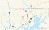
Maryland Route 136 is a state highway
in the U.S. state
of Maryland
. The state highway runs 30.04 miles (48.3 km) from MD 7
near Abingdon
north to MD 23
in Norrisville
. MD 136 is an L-shaped route that connects the communities of Creswell
, Churchville
, Dublin
, and Whiteford
in eastern Harford County
with each other and with Norrisville in the county's northwestern corner. The state highway is connected to the cities of Aberdeen
and Havre de Grace
via its connection with MD 22
. MD 136 is also linked to the county seat
of Bel Air from the east through MD 22, from the northeast by U.S. Route 1
(US 1), from the north via MD 24
, and from the northwest by MD 23. The state highway starts on the coastal plain
near the Chesapeake Bay
and crosses Harford County's two main tributaries of the Susquehanna River
, Deer Creek
and Broad Creek
, while traversing a wide swath of the Piedmont
. MD 136 is the second longest Maryland state highway entirely within one county after MD 235
.
The first section of MD 136 was constructed east from what is now MD 165
in Whiteford in the early 1920s. That highway was extended south to US 1 near Dublin in the mid 1920s. MD 136 was extended south to US 40
(now MD 7) in the early 1930s; the highway was also extended north from Whiteford to Graceton in the same period. The portion of MD 136 between MD 24
and MD 23 was originally MD 517, which was constructed in the mid 1930s. MD 136 was extended west over the gap between Graceton and MD 24 and assumed all of MD 517 to Norrisville in the mid 1950s.
. The junction is near the site of the signing of the Bush Declaration
, a 1775 resolution of Harford County citizens that supported the activities leading up to American Revolution
. MD 136 heads north through farmland as two-lane Calvary Road, which crosses over Interstate 95
(John F. Kennedy Memorial Highway) with no access. I-95 can be accessed via MD 543
(Fountain Green Road/Creswell Road), which MD 136 intersects in the village of Creswell.
North of Creswell, MD 136 passes to the west of Stoney Demonstration Forest
, crosses Broad Run adjacent to a quarry in the hamlet of Calvary, and passes close to the historic home Webster's Forest
, which is accessed via Asbury Road. The state highway continues north to Churchville, where MD 136 intersects MD 22 (Churchville Road) next to the village's namesake, Churchville Presbyterian Church
. A short distance east of the intersection, MD 22—which connects Bel Air and Aberdeen—intersects MD 155
(Level Road), which leads to Havre de Grace.
MD 136 leaves Churchville as Priestford Road, which passes by the Churchville Test Area
, an auxiliary unit of Aberdeen Proving Ground
used to test Army vehicles. The state highway traverses Deer Creek at Priest Ford, which is the site of Priest Neal's Mass House and Mill Site
, a historic church, and a junction with Harmony Church Road, which leads through the Lower Deer Creek Valley Historic District
. MD 136 passes a loop of old alignment, Poplar Grove Road, before intersecting US 1 (Conowingo Road) at an acute angle in the hamlet of Poplar Grove. The state highway continues north as Whiteford Road, which passes another loop of old alignment, Dublin School Road, before meeting MD 440
(Dublin Road) in the village of Dublin.
MD 136 heads northwest out of Dublin, crossing Broad Creek and intersecting Robinson Mill Road, which follows the creek east to the Broad Creek Soapstone Quarries
. The state highway intersects MD 646
(Prospect Road) in the hamlet of Prospect before approaching Whiteford. Whiteford and the neighboring village of Cardiff
are part of the Whiteford-Cardiff Historic District
, which preserve buildings from the 19th century when the area was a center of the slate industry
. MD 136 expands to a four-lane undivided highway and intersects Old Pylesville Road, which serves as the main street of the villages, before intersecting MD 165 (Pylesville Road).
MD 136 reduces to two lanes as it heads west from Whiteford toward the hamlet of Graceton, where the state highway intersects MD 624
(Graceton Road) within 2000 feet (609.6 m) of the Pennsylvania
state line. The state highway veers southwest and crosses Broad Run again before reaching Five Forks, where the state highway intersects Clermont Mill Road and MD 24 (Rocks Road). MD 136 heads west as Harkins Road, intersecting Fawn Grove Road in the hamlet of Harkins and traversing three tributaries of Deer Creek—Falling Branch, Big Branch, and Island Branch—before reaching its northern terminus at MD 23 (Norrisville Road) in Norrisville.
.
{|class=wikitable
!Location
!Mile
!Destinations
!Notes
|-
|Abingdon
|0.00
|
|Southern terminus
|-
|Creswell
|2.39
|
|
|-
|Churchville
|6.19
|
|
|-
|rowspan=2|Dublin
|11.81
|
|
|-
|12.81
|
|
|-
|Prospect
|16.24
|
|
|-
|Whiteford
|19.16
|
|
|-
|Graceton
|21.64
|
|
|-
|
|23.75
|
|
|-
|Norrisville
|30.04
|
|Northern terminus
State highway
State highway, state road or state route can refer to one of three related concepts, two of them related to a state or provincial government in a country that is divided into states or provinces :#A...
in the U.S. state
U.S. state
A U.S. state is any one of the 50 federated states of the United States of America that share sovereignty with the federal government. Because of this shared sovereignty, an American is a citizen both of the federal entity and of his or her state of domicile. Four states use the official title of...
of Maryland
Maryland
Maryland is a U.S. state located in the Mid Atlantic region of the United States, bordering Virginia, West Virginia, and the District of Columbia to its south and west; Pennsylvania to its north; and Delaware to its east...
. The state highway runs 30.04 miles (48.3 km) from MD 7
Maryland Route 7
Maryland Route 7 is a collection of state highways in the U.S. state of Maryland. These highways are sections of old alignment of U.S. Route 40 between Baltimore and Elkton that were bypassed when US 40 was moved to Pulaski Highway, a four-lane divided highway, in the late 1930s and early 1940s...
near Abingdon
Abingdon, Maryland
Abingdon is an unincorporated community in Harford County, Maryland, United States. It lies 25 miles northeast of Baltimore, near the Bush River.- History :Abingdon was named after Abingdon, England....
north to MD 23
Maryland Route 23
Maryland Route 23 is a state highway in the U.S. state of Maryland. The state highway runs from U.S. Route 1 in Hickory north and west to the Pennsylvania state line near Norrisville, where the highway continues as Pennsylvania Route 24 . MD 23 is an L-shaped highway in northwestern Harford...
in Norrisville
Norrisville, Maryland
Norrisville is an unincorporated community in Harford County, Maryland, just south of the Pennsylvania state line in the extreme northwest section of the county. It is primarily a farming community full of rolling hills and small valleys, and is part of the Deer Creek watershed. The area is served...
. MD 136 is an L-shaped route that connects the communities of Creswell
Creswell, Maryland
Creswell is an unincorporated community in Harford County, Maryland, United States. Fair Meadows was listed on the National Register of Historic Places in 1980.-References:...
, Churchville
Churchville, Maryland
Churchville is an unincorporated town in Harford County, Maryland, located between the county seat, Bel Air, and Aberdeen, where the Aberdeen Proving Ground is located.-History and Lower Cross Roads:...
, Dublin
Dublin, Maryland
Dublin is an unincorporated community in Harford County, Maryland, United States. Dublin was founded in the early 19th century by George McCausland and a friend who migrated from Dublin, Ireland.- History :...
, and Whiteford
Whiteford, Maryland
Whiteford is an unincorporated community in Harford County, Maryland, United States.The town, a part of the Whiteford-Cardiff Historic District, was added to the National Register of Historic Places in 2005. Until 1978, this community was served by the Maryland and Pennsylvania Railroad at...
in eastern Harford County
Harford County, Maryland
Harford County is a county in the U.S. state of Maryland. In 2010, its population was 244,826. Its county seat is Bel Air. Harford County forms part of the Baltimore-Washington Metropolitan Area.-History:...
with each other and with Norrisville in the county's northwestern corner. The state highway is connected to the cities of Aberdeen
Aberdeen, Maryland
As of the census of 2000, there were 13,842 people, 5,475 households, and 3,712 families residing in the city. The population density was 2,166.2 people per square mile . There were 5,894 housing units at an average density of 922.4 per square mile...
and Havre de Grace
Havre de Grace, Maryland
Havre de Grace is a city in Harford County, Maryland, United States. Located at the mouth of the Susquehanna River and the head of the Chesapeake Bay, Havre de Grace is named after the port city of Le Havre, France, which was first named Le Havre de Grâce, meaning in French "Harbor of Grace." As...
via its connection with MD 22
Maryland Route 22
Maryland Route 22 is a state highway in the U.S. state of Maryland. The state highway runs from U.S. Route 1 Business and MD 924 in Bel Air east to an entrance to Aberdeen Proving Ground in Aberdeen. MD 22 is the main connection between the county seat of Bel Air and Aberdeen, which is the...
. MD 136 is also linked to the county seat
County seat
A county seat is an administrative center, or seat of government, for a county or civil parish. The term is primarily used in the United States....
of Bel Air from the east through MD 22, from the northeast by U.S. Route 1
U.S. Route 1 in Maryland
U.S. Route 1 is the easternmost and longest of the major north–south routes of the United States Numbered Highway System, running from Key West, Florida to Fort Kent, Maine. In the U.S...
(US 1), from the north via MD 24
Maryland Route 24
Maryland Route 24 is a state highway in the U.S. state of Maryland. The state highway runs from an entrance to Aberdeen Proving Ground in Edgewood north to the Pennsylvania state line near Fawn Grove, Pennsylvania. MD 24 is the main north–south highway of Harford County...
, and from the northwest by MD 23. The state highway starts on the coastal plain
Atlantic Coastal Plain
The Atlantic coastal plain has both low elevation and low relief, but it is also a relatively flat landform extending from the New York Bight southward to a Georgia/Florida section of the Eastern Continental Divide, which demarcates the plain from the ACF River Basin in the Gulf Coastal Plain to...
near the Chesapeake Bay
Chesapeake Bay
The Chesapeake Bay is the largest estuary in the United States. It lies off the Atlantic Ocean, surrounded by Maryland and Virginia. The Chesapeake Bay's drainage basin covers in the District of Columbia and parts of six states: New York, Pennsylvania, Delaware, Maryland, Virginia, and West...
and crosses Harford County's two main tributaries of the Susquehanna River
Susquehanna River
The Susquehanna River is a river located in the northeastern United States. At long, it is the longest river on the American east coast that drains into the Atlantic Ocean, and with its watershed it is the 16th largest river in the United States, and the longest river in the continental United...
, Deer Creek
Deer Creek (Maryland)
Deer Creek is a river in Maryland that flows through the scenic areas of Harford County and empties into the Susquehanna River, roughly halfway between the Interstate 95 bridge and Conowingo Dam...
and Broad Creek
Broad Creek (Susquehanna River)
Broad Creek is a tributary of the lower Susquehanna River located in Harford County, Maryland.Broad Creek originates on the west side of Constitution Road, just south of the Pennsylvania state line. It runs generally south-southeast for to the Conowingo Reservoir along the Susquehanna...
, while traversing a wide swath of the Piedmont
Piedmont (United States)
The Piedmont is a plateau region located in the eastern United States between the Atlantic Coastal Plain and the main Appalachian Mountains, stretching from New Jersey in the north to central Alabama in the south. The Piedmont province is a physiographic province of the larger Appalachian division...
. MD 136 is the second longest Maryland state highway entirely within one county after MD 235
Maryland Route 235
Maryland Route 235 is a state highway in the U.S. state of Maryland. Known as Three Notch Road, the state highway runs between its southern intersection with MD 5 in Ridge and its northern intersection with MD 5 near Mechanicsville...
.
The first section of MD 136 was constructed east from what is now MD 165
Maryland Route 165
Maryland Route 165 is a state highway in the U.S. state of Maryland. The state highway runs from Baldwin north to the Pennsylvania state line in Cardiff, where the highway continues as Pennsylvania Route 74 . MD 165 passes through western and northern Harford County, where it connects the...
in Whiteford in the early 1920s. That highway was extended south to US 1 near Dublin in the mid 1920s. MD 136 was extended south to US 40
U.S. Route 40 in Maryland
U.S. Route 40 in the U.S. state of Maryland runs from western Maryland to Cecil County in the state's northeastern corner. With a total length of over , it is the longest numbered highway in Maryland. Almost half of the road overlaps with Interstate 68 or Interstate 70, while the old alignment...
(now MD 7) in the early 1930s; the highway was also extended north from Whiteford to Graceton in the same period. The portion of MD 136 between MD 24
Maryland Route 24
Maryland Route 24 is a state highway in the U.S. state of Maryland. The state highway runs from an entrance to Aberdeen Proving Ground in Edgewood north to the Pennsylvania state line near Fawn Grove, Pennsylvania. MD 24 is the main north–south highway of Harford County...
and MD 23 was originally MD 517, which was constructed in the mid 1930s. MD 136 was extended west over the gap between Graceton and MD 24 and assumed all of MD 517 to Norrisville in the mid 1950s.
Route description
MD 136 begins at an intersection with MD 7 (Philadelphia Road) east of Abingdon at the edge of Bush Declaration Natural Resources Management Area, just north of the confluence of Bynum Run and James Run to form the Bush RiverBush River (Maryland)
Bush River is a tidal estuary in Harford County, Maryland, located about 15 mi northeast of Baltimore. The estuary extends from the community of Riverside, south for about 9 mi , to the Chesapeake Bay...
. The junction is near the site of the signing of the Bush Declaration
Bush Declaration
The Bush Declaration, also known as the Bush River Declaration, the Bush River Resolution, and the Harford Declaration, was a resolution adopted on March 22, 1775, in Harford County, Maryland...
, a 1775 resolution of Harford County citizens that supported the activities leading up to American Revolution
American Revolution
The American Revolution was the political upheaval during the last half of the 18th century in which thirteen colonies in North America joined together to break free from the British Empire, combining to become the United States of America...
. MD 136 heads north through farmland as two-lane Calvary Road, which crosses over Interstate 95
Interstate 95 in Maryland
Interstate 95 in Maryland is a major highway that runs diagonally from northeast to southwest, from Maryland's border with Delaware, to the Woodrow Wilson Bridge, briefly entering the District of Columbia before reaching Virginia...
(John F. Kennedy Memorial Highway) with no access. I-95 can be accessed via MD 543
Maryland Route 543
Maryland Route 543 is a state highway in the U.S. state of Maryland. The state highway runs from U.S. Route 40 in Riverside north to MD 165 in Pylesville. MD 543 is a north–south highway through central Harford County that connects the communities of Creswell, Fountain Green, Hickory and...
(Fountain Green Road/Creswell Road), which MD 136 intersects in the village of Creswell.
North of Creswell, MD 136 passes to the west of Stoney Demonstration Forest
Stoney Demonstration Forest
Stoney Demonstration Forest is a state forest in the state of Maryland....
, crosses Broad Run adjacent to a quarry in the hamlet of Calvary, and passes close to the historic home Webster's Forest
Webster's Forest
Webster's Forest is a historic home located at Churchville, Harford County, Maryland, United States. It is a stone house constructed in two sections. The pre-1800 eastern section stands three bays wide, one and a half stories tall above a high basement, with a gambrel roof...
, which is accessed via Asbury Road. The state highway continues north to Churchville, where MD 136 intersects MD 22 (Churchville Road) next to the village's namesake, Churchville Presbyterian Church
Churchville Presbyterian Church
Churchville Presbyterian Church is a historic Presbyterian church located at Churchville, Harford County, Maryland. It consists of three harmoniously designed sections: the original one-story, four by three bay, gable-roofed brick building dated to 1820; the three-story, restrained Italianate,...
. A short distance east of the intersection, MD 22—which connects Bel Air and Aberdeen—intersects MD 155
Maryland Route 155
Maryland Route 155 is a state highway in the U.S. state of Maryland. Known for most of its length as Level Road, the state highway runs from MD 22 in Churchville east to U.S. Route 40 and MD 7 in Havre de Grace. In conjunction with MD 22, MD 155 serves as the main highway linking Bel Air and...
(Level Road), which leads to Havre de Grace.
MD 136 leaves Churchville as Priestford Road, which passes by the Churchville Test Area
Churchville Test Area
The Churchville Test Area is a United States Army facility of the Aberdeen Proving Ground, located northeast of Bel Air, Maryland ....
, an auxiliary unit of Aberdeen Proving Ground
Aberdeen Proving Ground
Aberdeen Proving Ground is a United States Army facility located near Aberdeen, Maryland, . Part of the facility is a census-designated place , which had a population of 3,116 at the 2000 census.- History :...
used to test Army vehicles. The state highway traverses Deer Creek at Priest Ford, which is the site of Priest Neal's Mass House and Mill Site
Priest Neal's Mass House and Mill Site
Priest Neal's Mass House and Mill Site, also known as Paradice, is a historic Roman Catholic Church located at Bel Air, Harford County, Maryland. It is a stuccoed, -story stone dwelling constructed about 1743 by Jesuits for use as a mission before Roman Catholics obtained freedom of worship under...
, a historic church, and a junction with Harmony Church Road, which leads through the Lower Deer Creek Valley Historic District
Lower Deer Creek Valley Historic District
Lower Deer Creek Valley Historic District is a national historic district near Darlington, Harford County, Maryland, United States. It comprises approximately in north central Harford County. The primary building material is stone taken from local quarries and used to construct houses, mills,...
. MD 136 passes a loop of old alignment, Poplar Grove Road, before intersecting US 1 (Conowingo Road) at an acute angle in the hamlet of Poplar Grove. The state highway continues north as Whiteford Road, which passes another loop of old alignment, Dublin School Road, before meeting MD 440
Maryland Route 440
Maryland Route 440 is a state highway in the U.S. state of Maryland. Known as Dublin Road, the state highway runs from MD 543 in Ady east to U.S. Route 1 near Dublin. MD 440 was built between Ady and MD 136 in Dublin in the early 1930s and extended to US 1 in 1956.-Route description:MD 440...
(Dublin Road) in the village of Dublin.
MD 136 heads northwest out of Dublin, crossing Broad Creek and intersecting Robinson Mill Road, which follows the creek east to the Broad Creek Soapstone Quarries
Broad Creek Soapstone Quarries
The Broad Creek Soapstone Quarries, also known as Orr Prehistoric Steatite Quarry Archeological Site, is an archeological site located near Whiteford, Harford County, Maryland. The site includes evidence of the manufacture of vessels from boulders instead of from bedrock...
. The state highway intersects MD 646
Maryland Route 646
Maryland Route 646 is a state highway in the U.S. state of Maryland. Known as Prospect Road, the state highway runs from MD 543 near Ady north to MD 136 in Prospect. MD 646 was constructed as a section of MD 543 in the early 1930s...
(Prospect Road) in the hamlet of Prospect before approaching Whiteford. Whiteford and the neighboring village of Cardiff
Cardiff, Maryland
Cardiff is an unincorporated community in Harford County, Maryland, United States. The population was 518 at the 2000 census. Zipcode for the area is 21160. It takes its name from the Capital city of Wales.-Geography:...
are part of the Whiteford-Cardiff Historic District
Whiteford-Cardiff Historic District
Whiteford-Cardiff Historic District is a national historic district at Cardiff and Whiteford, Harford County, Maryland, United States. It encompasses portions of two communities in northern Harford County that were historically associated with slate production during the late 19th and early 20th...
, which preserve buildings from the 19th century when the area was a center of the slate industry
Slate industry
The slate industry is the industry related to the extraction and processing of slate. Slate is either quarried from a slate quarry or reached by tunneling in a slate mine. Common uses for slate include as a roofing material, a flooring material, gravestones and memorial tablets, and for electrical...
. MD 136 expands to a four-lane undivided highway and intersects Old Pylesville Road, which serves as the main street of the villages, before intersecting MD 165 (Pylesville Road).
MD 136 reduces to two lanes as it heads west from Whiteford toward the hamlet of Graceton, where the state highway intersects MD 624
Maryland Route 624
Maryland Route 624 is a state highway in the U.S. state of Maryland. The state highway runs from MD 165 in Pylesville north to the Pennsylvania state line a short distance north of the intersection with MD 136 in Graceton. MD 624 was constructed in the mid 1930s.-Route description:MD 624 begins...
(Graceton Road) within 2000 feet (609.6 m) of the Pennsylvania
Pennsylvania
The Commonwealth of Pennsylvania is a U.S. state that is located in the Northeastern and Mid-Atlantic regions of the United States. The state borders Delaware and Maryland to the south, West Virginia to the southwest, Ohio to the west, New York and Ontario, Canada, to the north, and New Jersey to...
state line. The state highway veers southwest and crosses Broad Run again before reaching Five Forks, where the state highway intersects Clermont Mill Road and MD 24 (Rocks Road). MD 136 heads west as Harkins Road, intersecting Fawn Grove Road in the hamlet of Harkins and traversing three tributaries of Deer Creek—Falling Branch, Big Branch, and Island Branch—before reaching its northern terminus at MD 23 (Norrisville Road) in Norrisville.
History
The first section of MD 136 to be constructed was Whiteford Road from Prospect to Whiteford by 1923. The remainder of Whiteford Road south to US 1 was constructed between 1924 and 1927. Priestford Road was built starting in 1930 from US 1. Both the Priestford Road and Calvary Road portions of MD 136 were completed in 1932, including a new bridge over Deer Creek at Priest Ford. In 1933, MD 136 achieved its original extent when the state highway was extended north from Whiteford to Graceton. The Harkins Road portion of MD 136 was originally designated MD 517. MD 517 was constructed as a modern highway from MD 24 at Five Forks west to Harkins in 1933. Harkins Road was extended west 2 miles (3.2 km) from Harkins in 1934 and 1935. MD 517 was completed west to MD 23 in Norrisville in 1936. MD 136 was relocated through Dublin in 1952 and 1953. The state highway reached its current extent in 1956 when the county highway between Graceton and Five Forks was transferred to state control; MD 136 was extended southwest to Five Forks then assumed all of MD 517 to its present northern terminus in Norrisville.Junction list
The entire route is in Harford CountyHarford County, Maryland
Harford County is a county in the U.S. state of Maryland. In 2010, its population was 244,826. Its county seat is Bel Air. Harford County forms part of the Baltimore-Washington Metropolitan Area.-History:...
.
{|class=wikitable
!Location
!Mile
!Destinations
!Notes
|-
|Abingdon
Abingdon, Maryland
Abingdon is an unincorporated community in Harford County, Maryland, United States. It lies 25 miles northeast of Baltimore, near the Bush River.- History :Abingdon was named after Abingdon, England....
|0.00
|
|Southern terminus
|-
|Creswell
Creswell, Maryland
Creswell is an unincorporated community in Harford County, Maryland, United States. Fair Meadows was listed on the National Register of Historic Places in 1980.-References:...
|2.39
|
|
|-
|Churchville
Churchville, Maryland
Churchville is an unincorporated town in Harford County, Maryland, located between the county seat, Bel Air, and Aberdeen, where the Aberdeen Proving Ground is located.-History and Lower Cross Roads:...
|6.19
|
|
|-
|rowspan=2|Dublin
Dublin, Maryland
Dublin is an unincorporated community in Harford County, Maryland, United States. Dublin was founded in the early 19th century by George McCausland and a friend who migrated from Dublin, Ireland.- History :...
|11.81
|
|
|-
|12.81
|
|
|-
|Prospect
|16.24
|
|
|-
|Whiteford
Whiteford, Maryland
Whiteford is an unincorporated community in Harford County, Maryland, United States.The town, a part of the Whiteford-Cardiff Historic District, was added to the National Register of Historic Places in 2005. Until 1978, this community was served by the Maryland and Pennsylvania Railroad at...
|19.16
|
|
|-
|Graceton
|21.64
|
|
|-
|
|23.75
|
|
|-
|Norrisville
Norrisville, Maryland
Norrisville is an unincorporated community in Harford County, Maryland, just south of the Pennsylvania state line in the extreme northwest section of the county. It is primarily a farming community full of rolling hills and small valleys, and is part of the Deer Creek watershed. The area is served...
|30.04
|
|Northern terminus