
Maryland Route 130
Encyclopedia
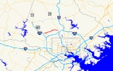
Maryland Route 130, better known as Greenspring Valley Road, is a state road in Baltimore County, Maryland that operates cross-county from Owings Mills
to Lutherville. With the exception of turning lanes in various locations, the entire route of the road has only one travel lane in each direction.
, which it retains until Falls Road
, where the name Greenspring Valley Road ends, but the street continues as a private roadway for two more blocks under the name Station Drive. This area of Lutherville is known as Brooklandville or Greenspring Station. The route also crosses Maryland Route 129
, also known as Park Heights Avenue.
Along the entire route, travel speed is limited to 30-35 miles per hour due to the numerous sharp curves. In one location along the route that has previously seen a large number of accidents, rumble strips have been installed to warn and slow motorists prior to a 90-degree curve. Also, at the intersection with Garrison Forest Road, a 3-way stop has been installed to increase safety for drivers.
on the No. M-10 Line, is available on Greenspring Valley Road between Falls Road and Villa Julie College on weekdays between 7 AM and 10 AM, and between 3 PM and 7 PM. These buses connect to the Baltimore Metro Subway
and Central Light Rail line.
Service was previously provided between Park Heights and Greenspring Avenue
s on the No. M-12 Line on a limited basis. However, this was discontinued on October 23, 2005.
.
Owings Mills, Maryland
Owings Mills is an unincorporated community and a census-designated place in Baltimore County, Maryland, United States. It is a suburb of Baltimore. The population was 20,193 at the 2000 census. Owings Mills is home to the northern terminus for the Baltimore Metro Subway and to Owings Mills Mall....
to Lutherville. With the exception of turning lanes in various locations, the entire route of the road has only one travel lane in each direction.
Route description
Greenspring Valley Road starts within a community in Owings Mills known as McDonough Township, found to the west of Reisterstown Road. But the road only picks up the state designation on the east of Reisterstown RoadMaryland Route 140
Maryland Route 140 is a local long route in northern Maryland, United States.-Route description:MD 140 is known by various names depending on location; south of Reisterstown it is known as Reisterstown Road. Though Reisterstown itself is named after John Reister, the road is named after Jacob...
, which it retains until Falls Road
Maryland Route 25
Maryland Route 25 , locally known for nearly its entire length as Falls Road, is a state highway in the U.S. state of Maryland. It begins north of downtown Baltimore, just north of Penn Station, and continues north through Baltimore County almost to the Pennsylvania state line...
, where the name Greenspring Valley Road ends, but the street continues as a private roadway for two more blocks under the name Station Drive. This area of Lutherville is known as Brooklandville or Greenspring Station. The route also crosses Maryland Route 129
Maryland Route 129
Maryland Route 129 is a state highway in the U.S. state of Maryland, running north-northwesterly from downtown Baltimore into Baltimore County, ending east of Reisterstown...
, also known as Park Heights Avenue.
Along the entire route, travel speed is limited to 30-35 miles per hour due to the numerous sharp curves. In one location along the route that has previously seen a large number of accidents, rumble strips have been installed to warn and slow motorists prior to a 90-degree curve. Also, at the intersection with Garrison Forest Road, a 3-way stop has been installed to increase safety for drivers.
Points of interest
The majority of the route is lined with upscale communities and undeveloped land. But a few well-known landmarks can be found along the route. These include:- Stevenson University (Formerly: Villa Julie CollegeVilla Julie CollegeStevenson University is a private, independent, coeducational, liberal arts college is located in the Greenspring Valley area of Baltimore County, Maryland, United States. The University has two campuses, one in Stevenson and one in Owings Mills, with approximately 3,400 undergraduate and graduate...
), Stevenson Campus - Gramercy MansionGramercy MansionGramercy Mansion is a historic mansion in Stevenson, Maryland, United States, located on Greenspring Valley Road near Stevenson University, formerly Villa Julie College. It was built in 1902 by Alexander J. Cassatt, owner of the Pennsylvania Railroad and brother of the American Impressionist...
Bed and BreakfastBed and breakfastA bed and breakfast is a small lodging establishment that offers overnight accommodation and breakfast, but usually does not offer other meals. Since the 1980s, the meaning of the term has also extended to include accommodations that are also known as "self-catering" establishments...
and Conference Center - Greenspring Station, including Johns Hopkins HospitalJohns Hopkins HospitalThe Johns Hopkins Hospital is the teaching hospital and biomedical research facility of Johns Hopkins University School of Medicine, located in Baltimore, Maryland . It was founded using money from a bequest by philanthropist Johns Hopkins...
Outpatient Center - St. Paul's School (Brooklandville, Maryland)
Public transportation
Bus service, provided by the Maryland Transit AdministrationMaryland Transit Administration
The Maryland Transit Administration is a state-operated mass transit administration in Maryland, and is part of the Maryland Department of Transportation. It is better known as MTA Maryland to avoid confusion with other cities' transit agencies who share the initials MTA. The MTA operates a...
on the No. M-10 Line, is available on Greenspring Valley Road between Falls Road and Villa Julie College on weekdays between 7 AM and 10 AM, and between 3 PM and 7 PM. These buses connect to the Baltimore Metro Subway
Baltimore Metro Subway
The Baltimore Metro Subway, known locally as the Metro Subway, The Subway, or Baltimore Metro is a rapid transit line serving the greater Baltimore, Maryland, United States area and operated by the Maryland Transit Administration...
and Central Light Rail line.
Service was previously provided between Park Heights and Greenspring Avenue
Greenspring Avenue
Greenspring Avenue is a road in Baltimore, Maryland and its northwestern suburbs. At one time, Greenspring Avenue was Maryland Route 519 from Worthington Road to Dover Road, but the road has since been decommissioned and no longer has any numerical designation....
s on the No. M-12 Line on a limited basis. However, this was discontinued on October 23, 2005.
Junction list
The entire route is in Baltimore CountyBaltimore County, Maryland
Baltimore County is a county located in the northern part of the US state of Maryland. In 2010, its population was 805,029. It is part of the Baltimore-Washington Metropolitan Area. Its county seat is Towson. The name of the county was derived from the barony of the Proprietor of the Maryland...
.
| Location | Mile |
Roads intersected | Notes |
|---|---|---|---|
| Owings Mills | 0.00 | Western terminus | |
| 1.74 | |||
| Lutherville | 5.57 | Eastern terminus |