
Baltimore Metro Subway
Encyclopedia
The Baltimore Metro Subway, known locally as the Metro Subway, The Subway, or Baltimore Metro is a rapid transit
line serving the greater Baltimore, Maryland, United States
area and operated by the Maryland Transit Administration
. Despite its name, less than half of the line is underground; most of the line outside of the central city is elevated or at grade.
As the vision was translated into reality, the original concept was trimmed to a 28 mi (45.1 km) system in the Phase 1 plan, published in 1971. This plan involved two of the original six lines: a northwest line from Downtown Baltimore to Owings Mills and a south line to Glen Burnie and the airport. Phase 1 was approved for funding by the Maryland General Assembly in 1972. In response to crime concerns of Anne Arundel County
residents, the MTA eliminated the south line from Phase 1 plans in 1975.
When the Baltimore Metro opened on November 21, 1983, only the "Northwest" line of the 1965 plan had come to fruition. This 12.2 km (7.6 mi) segment provided service between Charles Center in Downtown Baltimore and Reisterstown Plaza in the northwest section of the city. In 1987, a 9.8 kilometres (6.1 mi) addition extended the line from Reisterstown Road Plaza to Owings Mills
in Baltimore County, much of it running in the median of I-795
. A further extension of 2.5 km (1.6 mi) from Charles Center to Johns Hopkins Hospital
was opened in 1994.
Once the project was completed in 1995, the total cost for the Metro Subway was $1.392 billion.
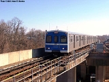
The current system is 24.8 km (15.4 mi) long, including 10 km (6.2 mi) underground, 3.5 km (2.2 mi) elevated, and 11.3 km (7 mi) at grade. Eight of its 14 stations are underground, at depths of 16 m (52.5 ft) to 34 m (111.5 ft) below street level. Its elevated stations stand from 25 ft (7.6 m) to 28 ft (8.5 m) above ground.
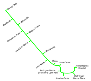 The Metro Subway's route consists of a single line in a shape that can be described as an extremely lopsided "U". Trains head due south underground from Johns Hopkins Hospital, turn west as they pass under Baltimore's central business district, then north and ultimately northwest towards Owings Mills. The route leaves its tunnel northwest of Mondawmin station, entering an elevated structure that parallels Wabash Avenue and the Western Maryland Railroad. The route eventually leaves the older railroad right of way
to enter the I-795 median, which it occupies all the way to the system's Owings Mills terminus.
Trains heading for Johns Hopkins Hospital are referred to as "eastbound" trains, while trains heading towards Owings Mills are said to be "westbound".
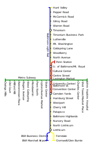
There is no direct connection to the Light Rail or to MARC
. The Metro Subway's Lexington Market Station is a 200 yards (182.9 m) walk from the Light Rail stop of the same name, and the State Center Station is about 1.5 blocks away from Light Rail's Cultural Center. In addition, MARC Penn Station is about a one-half mile walk from State Center, and MARC Camden Station is about five blocks from Lexington Market.
Source:
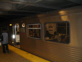
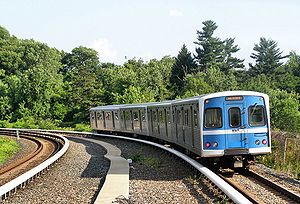 The Baltimore Metro's cars were manufactured by the Budd/TransitAmerica
Red Lion plant in Northeast Philadelphia
. Most were delivered in 1983, with a supplementary set of essentially identical cars being purchased in 1986 for the line expansion. The cars, marketed by Budd as the Universal Transit Vehicle, are identical to those used on the Miami Metrorail, because the two agencies built their systems at the same time and saved money by sharing a single order.
These cars were among the last railcars to be built by Budd before the firm shut down.
Trains draw power from an electric third rail
. The cars are 75 feet (22.9 m) long, 10 feet (3 m) wide and have a top speed of over 70 mi/h. Cars are semi-permanently attached in married pairs, and 2-, 4-, and 6-car trains are all seen on the line. Each car can hold up to 166 passengers (76 seated, 90 standing).
The Baltimore Metro fleet had a significant overhaul between 2002 and 2005. Car seats were replaced and the floors reupholstered. External destination rollsigns were replaced with LED displays, and internal systems that displayed and announced train destinations and upcoming stops were installed.
The MTA currently owns 100 Metro Subway cars; approximately 54 are in use during peak weekday travel times.
, dubbed the Green Line
(which reflects the Metro Subway's color on MTA Maryland maps). Due to the expected high cost of building it as an extension of the existing Metro Subway (which would require tunneling in densely populated neighborhoods), the extension may take the form of a connecting light rail
or bus rapid transit
service. As of 2011, plans have not progressed.
Rapid transit
A rapid transit, underground, subway, elevated railway, metro or metropolitan railway system is an electric passenger railway in an urban area with a high capacity and frequency, and grade separation from other traffic. Rapid transit systems are typically located either in underground tunnels or on...
line serving the greater Baltimore, Maryland, United States
United States
The United States of America is a federal constitutional republic comprising fifty states and a federal district...
area and operated by the Maryland Transit Administration
Maryland Transit Administration
The Maryland Transit Administration is a state-operated mass transit administration in Maryland, and is part of the Maryland Department of Transportation. It is better known as MTA Maryland to avoid confusion with other cities' transit agencies who share the initials MTA. The MTA operates a...
. Despite its name, less than half of the line is underground; most of the line outside of the central city is elevated or at grade.
History
The origins of the Metro Subway lie in the Baltimore Area Mass Transportation Plan, published in 1965, which envisioned six rapid transit lines radiating out from a central city loop. Planning studies from 1968 proposed a rail transit system 71 mi (114.3 km) long.As the vision was translated into reality, the original concept was trimmed to a 28 mi (45.1 km) system in the Phase 1 plan, published in 1971. This plan involved two of the original six lines: a northwest line from Downtown Baltimore to Owings Mills and a south line to Glen Burnie and the airport. Phase 1 was approved for funding by the Maryland General Assembly in 1972. In response to crime concerns of Anne Arundel County
Anne Arundel County, Maryland
Anne Arundel County is a county located in the U.S. state of Maryland. It is named for Anne Arundell , a member of the ancient family of Arundells in Cornwall, England and the wife of Cæcilius Calvert, 2nd Baron Baltimore. Its county seat is Annapolis, which is also the capital of the state...
residents, the MTA eliminated the south line from Phase 1 plans in 1975.
When the Baltimore Metro opened on November 21, 1983, only the "Northwest" line of the 1965 plan had come to fruition. This 12.2 km (7.6 mi) segment provided service between Charles Center in Downtown Baltimore and Reisterstown Plaza in the northwest section of the city. In 1987, a 9.8 kilometres (6.1 mi) addition extended the line from Reisterstown Road Plaza to Owings Mills
Owings Mills, Maryland
Owings Mills is an unincorporated community and a census-designated place in Baltimore County, Maryland, United States. It is a suburb of Baltimore. The population was 20,193 at the 2000 census. Owings Mills is home to the northern terminus for the Baltimore Metro Subway and to Owings Mills Mall....
in Baltimore County, much of it running in the median of I-795
Interstate 795 (Maryland)
Interstate 795 , also known as the Northwest Expressway, is a nine-mile freeway linking Baltimore's northwestern suburbs of Pikesville, Owings Mills and Reisterstown, Maryland to the Baltimore Beltway...
. A further extension of 2.5 km (1.6 mi) from Charles Center to Johns Hopkins Hospital
Johns Hopkins Hospital
The Johns Hopkins Hospital is the teaching hospital and biomedical research facility of Johns Hopkins University School of Medicine, located in Baltimore, Maryland . It was founded using money from a bequest by philanthropist Johns Hopkins...
was opened in 1994.
Once the project was completed in 1995, the total cost for the Metro Subway was $1.392 billion.
The current system is 24.8 km (15.4 mi) long, including 10 km (6.2 mi) underground, 3.5 km (2.2 mi) elevated, and 11.3 km (7 mi) at grade. Eight of its 14 stations are underground, at depths of 16 m (52.5 ft) to 34 m (111.5 ft) below street level. Its elevated stations stand from 25 ft (7.6 m) to 28 ft (8.5 m) above ground.
Route
Right-of-way (railroad)
A right-of-way is a strip of land that is granted, through an easement or other mechanism, for transportation purposes, such as for a trail, driveway, rail line or highway. A right-of-way is reserved for the purposes of maintenance or expansion of existing services with the right-of-way...
to enter the I-795 median, which it occupies all the way to the system's Owings Mills terminus.
Trains heading for Johns Hopkins Hospital are referred to as "eastbound" trains, while trains heading towards Owings Mills are said to be "westbound".
Schedules
A trip from one end of the line to the other takes about half an hour. Headways range from 8 minutes during daytime peak to 11 minutes late at night and on weekends. Trains run from 5 a.m. to midnight on weekdays, 6 a.m. to midnight on weekends.Connecting services
Most Metro Subway stations are served by a number of MTA bus routes. In 1984, just months after Metro first started operating, many feeder routes were created that were given the designation of a letter (M, P, or R) followed by a number. In 1987, many of these routes were renamed, and only the prefix "M" was used. Over the years, the number of M-lines has shrunken, as many of the routes were consolidated. In 2008, routes that were designated with the letter "M" have been renamed to plain two-digit designations. Finally, on August 30, 2009, the last four were either renumbered or eliminated, with no routing changes made; they continue to act as feeder routes to the Metro Subway.There is no direct connection to the Light Rail or to MARC
MARC Train
MARC , known prior to 1984 as Maryland Rail Commuter Service, is a regional rail system comprising three lines in the Baltimore-Washington Metropolitan Area. MARC is administered by the Maryland Transit Administration , a Maryland Department of Transportation agency, and is operated under contract...
. The Metro Subway's Lexington Market Station is a 200 yards (182.9 m) walk from the Light Rail stop of the same name, and the State Center Station is about 1.5 blocks away from Light Rail's Cultural Center. In addition, MARC Penn Station is about a one-half mile walk from State Center, and MARC Camden Station is about five blocks from Lexington Market.
Stations and connecting services
| Station | Location | Parking | Connections | Connections within close walk |
|---|---|---|---|---|
| Owings Mills Owings Mills (Metro Subway station) The Owings Mills Metro Subway Station is one of 14 stops along the Baltimore Metro Subway line. It is the most northern and western station on the line, and has more parking spaces than all other stops along the line.... |
Painters Mill Road near I-795 Interstate 795 (Maryland) Interstate 795 , also known as the Northwest Expressway, is a nine-mile freeway linking Baltimore's northwestern suburbs of Pikesville, Owings Mills and Reisterstown, Maryland to the Baltimore Beltway... underpass |
3500 | MTA buses: 56 Route 56 (MTA Maryland) Route 56 is a bus route operated by the Maryland Transit Administration in the suburbs of Baltimore. The route currently runs from the Owings Mills Town Center to Glyndon via Reisterstown Road and the Owings Mills Metro Subway Station... , 59 Route 59 (MTA Maryland) Route 59 is a bus route operated by the Maryland Transit Administration in Baltimore and its suburbs, mostly along Reisterstown Road. The line currently runs from the Reisterstown Plaza Metro Subway Station to the Owings Mills Town Center. The line was a split-off from Route M-9, and resembles the... |
|
| Old Court Old Court (Metro Subway station) The Old Court Metro Subway Station is one of 14 stops along the Baltimore Metro Subway line, located in Pikesville, Maryland. It is the second most northern and western station on the line, with approximately 625 parking spaces.... |
Old Court Road Old Court Road Old Court Road is a major cross-county road in the central region of the U.S. state of Maryland, running east–west for approximately through Baltimore County, Maryland from just inside Howard County, Maryland at Woodstock on the Patapsco River to Maryland Route 25 near Towson... near Greenwood Road |
625 | MTA buses: 18 Route 18 (MTA Maryland) Route 18 is a school-day only bus route operated by the Maryland Transit Administration in Baltimore. The line currently runs from Glen Avenue & Key Avenue in Northwest Baltimore to Smith Avenue & Copper Ridge Rd in Mount Washington or Old Court Road & Scotts Hill Dr in Pikesville or Park Heights... , 53 Route 53 (MTA Maryland) Route 53 is a bus route in Baltimore and its suburbs. The line currently runs from the Old Court Metro Subway Station in Pikesville, Maryland to the Mondawmin Metro Subway Station in Northwest Baltimore along Old Court Road and Reisterstown Road, serving the communities of Park Heights and the... , 77 Route 77 (MTA Maryland) Route 77 is a bus route operated by the Maryland Transit Administration in the suburbs of Baltimore. The line currently runs from the Old Court Metro Subway Station in Pikesville, Maryland to the Patapsco Light Rail Stop, and serves Randallstown, Windsor Mill, Woodlawn, Catonsville, Arbutus,... , 99 Route 99 (MTA Maryland) Route 99 is a bus route operated by the Maryland Transit Administration in the suburbs of Baltimore. The line currently runs from the Old Court Metro Subway Station in Pikesville, Maryland to BWI Thurgood Marshall Airport, and serves Randallstown, Windsor Mill, Woodlawn, Catonsville, Arbutus,... |
|
| Milford Mill Milford Mill (Metro Subway station) The Milford Mill Metro Subway Station is one of 14 stops along the Baltimore Metro Subway line, located in Pikesville, Maryland. It is the third most northern and western station on the line, with approximately 1300 parking spaces.... |
Roman Frasier Lane and Bedford Road (near Milford Mill Road) | 1300 | MTA buses: 54 Route 54 (MTA Maryland) Route 54 is a bus route that operates in Baltimore and its suburbs, serving the corridors of Park Heights Avenue, Milford Mill Road, and Liberty Road. All trips operate from the Penn-North Metro Subway Station in Baltimore City to the Milford Mill Metro Subway Station in Pikesville. From there,... |
|
| Reisterstown Plaza Reisterstown Plaza (Metro Subway station) The Reisterstown Plaza Metro Subway Station is one of 14 stops along the Baltimore Metro Subway line, located in Baltimore, Maryland, near the intersection of Patterson, and Wabash Avenues. It is the fourth most northern and western station on the line, with approximately 700 parking spaces. It is... |
Wabash Avenue and Patterson Avenue | 700 | MTA buses: 27, 58 Route 58 (MTA Maryland) Route 58 is a bus route operated by the Maryland Transit Administration in Baltimore and its suburbs. The line's western terminus is the Reisterstown Plaza Metro Subway Station, and its eastern terminus is White Marsh Mall, though some peak hour trips make short turns in Overlea.... , 59 Route 59 (MTA Maryland) Route 59 is a bus route operated by the Maryland Transit Administration in Baltimore and its suburbs, mostly along Reisterstown Road. The line currently runs from the Reisterstown Plaza Metro Subway Station to the Owings Mills Town Center. The line was a split-off from Route M-9, and resembles the... , 60 Route 60 (MTA Maryland) Route 60 is a bus route operated by the Maryland Transit Administration in Baltimore and its suburbs. The line currently operates weekdays only from the Reisterstown Plaza Metro Subway Station to Stevenson University during peak hours and Greenspring Station midday.The route is based on that of the... |
MTA buses: 53 Route 53 (MTA Maryland) Route 53 is a bus route in Baltimore and its suburbs. The line currently runs from the Old Court Metro Subway Station in Pikesville, Maryland to the Mondawmin Metro Subway Station in Northwest Baltimore along Old Court Road and Reisterstown Road, serving the communities of Park Heights and the... |
| Rogers Avenue Rogers Avenue (Metro Subway station) The Rogers Avenue Metro Subway Station is one of 14 stops along the Baltimore Metro Subway line, located in Baltimore, Maryland, in the Arlington area. It is the fifth most northern and western station on the line, with approximately 900 parking spaces... |
Rogers Avenue at Wabash Avenue | 900 | MTA buses: 27, 33 Route 33 (MTA Maryland) Route 33 is a bus route operated by the Maryland Transit Administration in Baltimore. The line currently runs from the Rogers Avenue Metro Subway Station in Northwest Baltimore to a loop in Moravia in Northeast Baltimore. Service is provided about once every 10-15 minutes during rush hour, every 20... , 44 Route 44 (MTA Maryland) Route 44 is a bus route operated by the Maryland Transit Administration in Baltimore and its suburbs. The line currently runs from Rosedale Industrial Park near Pulaski Highway just outside the Baltimore city limits on the east side of the city across the northern portion of the city to Security... , 51 Route 51 (MTA Maryland) Route 51 is a bus route operated by the Maryland Transit Administration in Baltimore and its suburbs. The line currently runs from the Rogers Avenue Metro Subway Station to the Patapsco Light Rail Stop, serving the communities of Arlington, Ashburton, Mondawmin, Rosemont, Baltimore, Cherry Hill,... , 57, 67, 91 |
MTA buses: 53 Route 53 (MTA Maryland) Route 53 is a bus route in Baltimore and its suburbs. The line currently runs from the Old Court Metro Subway Station in Pikesville, Maryland to the Mondawmin Metro Subway Station in Northwest Baltimore along Old Court Road and Reisterstown Road, serving the communities of Park Heights and the... |
| West Coldspring West Coldspring (Metro Subway station) The West Coldspring Metro Subway Station is one of 14 stops along the Baltimore Metro Subway line, located in Baltimore, Maryland, in the Arlington area at the intersection of Wabash Avenue and Coldspring Lane. It is the sixth most northern and western station on the line, with approximately 300... |
Wabash Avenue at Coldspring Lane | 300 | MTA buses: 33 Route 33 (MTA Maryland) Route 33 is a bus route operated by the Maryland Transit Administration in Baltimore. The line currently runs from the Rogers Avenue Metro Subway Station in Northwest Baltimore to a loop in Moravia in Northeast Baltimore. Service is provided about once every 10-15 minutes during rush hour, every 20... , 51 Route 51 (MTA Maryland) Route 51 is a bus route operated by the Maryland Transit Administration in Baltimore and its suburbs. The line currently runs from the Rogers Avenue Metro Subway Station to the Patapsco Light Rail Stop, serving the communities of Arlington, Ashburton, Mondawmin, Rosemont, Baltimore, Cherry Hill,... , 97 Route 97 (MTA Maryland) Route 97, also known as the Mondawmin Shuttle Bug or Mondawmin Shuttle, is one of two neighborhood shuttle routes operated by the Maryland Transit Administration in Baltimore. It was the second and is so far the final in the series of shuttle bugs to be introduced in the 2000s... |
MTA buses: 53 Route 53 (MTA Maryland) Route 53 is a bus route in Baltimore and its suburbs. The line currently runs from the Old Court Metro Subway Station in Pikesville, Maryland to the Mondawmin Metro Subway Station in Northwest Baltimore along Old Court Road and Reisterstown Road, serving the communities of Park Heights and the... |
| Mondawmin Mondawmin (Metro Subway station) Mondawmin is a rapid transit station on the Metro Subway in Mondawmin, Baltimore, Maryland, United States. It is located under the intersection of Reisterstown Road and Liberty Heights Avenue, adjacent to the Mondawmin Mall... |
Liberty Heights Avenue Maryland Route 26 Maryland Route 26 is an east–west state highway in the U.S. state of Maryland. Outside of the Baltimore city limits, it is known as Liberty Road; inside the city limits it is known as Liberty Heights Avenue.... at Reisterstown Road Maryland Route 140 Maryland Route 140 is a local long route in northern Maryland, United States.-Route description:MD 140 is known by various names depending on location; south of Reisterstown it is known as Reisterstown Road. Though Reisterstown itself is named after John Reister, the road is named after Jacob... |
175 | MTA buses: 1, 5, 7, 16 Route 16 (MTA Maryland) Route 16 is a bus route operated by the Maryland Transit Administration in Baltimore. The line currently runs from the Mondawmin Metro Subway Station in Northwest Baltimore to Brooklyn Homes in South Baltimore through the communities of Rosemont and the corridors of Hilton Street, Caton Avenue,... , 21, 22 Route 22 (MTA Maryland) Route 22 is a bus route operated by the Maryland Transit Administration in Baltimore. The line currently operates between the Mondawmin Metro Subway Station and Bayview Medical Center, serving Television Hill, the Woodberry Light Rail Stop), Hampden, The Rotunda, Homewood, Johns Hopkins University,... , 51 Route 51 (MTA Maryland) Route 51 is a bus route operated by the Maryland Transit Administration in Baltimore and its suburbs. The line currently runs from the Rogers Avenue Metro Subway Station to the Patapsco Light Rail Stop, serving the communities of Arlington, Ashburton, Mondawmin, Rosemont, Baltimore, Cherry Hill,... , 52 Route 52 (MTA Maryland) Route 52 is a bus route operated by the Maryland Transit Administration in Baltimore and its suburbs. The line currently runs from the Mondawmin Metro Subway Station along Liberty Heights Avenue and Liberty Road to a loop known as in Milford Mill with buses marked as "Milford Mill"... , 53 Route 53 (MTA Maryland) Route 53 is a bus route in Baltimore and its suburbs. The line currently runs from the Old Court Metro Subway Station in Pikesville, Maryland to the Mondawmin Metro Subway Station in Northwest Baltimore along Old Court Road and Reisterstown Road, serving the communities of Park Heights and the... , 54 Route 54 (MTA Maryland) Route 54 is a bus route that operates in Baltimore and its suburbs, serving the corridors of Park Heights Avenue, Milford Mill Road, and Liberty Road. All trips operate from the Penn-North Metro Subway Station in Baltimore City to the Milford Mill Metro Subway Station in Pikesville. From there,... , 97 Route 97 (MTA Maryland) Route 97, also known as the Mondawmin Shuttle Bug or Mondawmin Shuttle, is one of two neighborhood shuttle routes operated by the Maryland Transit Administration in Baltimore. It was the second and is so far the final in the series of shuttle bugs to be introduced in the 2000s... |
|
| Penn-North Penn–North (Metro Subway station) The Penn-North Metro Subway Station is one of 14 stops along the Baltimore Metro Subway line. Its name comes from its location, at the corner of Pennsylvania and North Avenues. It is the eighth most northern and western station on the line, and the first station when starting from Owings Mills that... |
Pennsylvania Avenue at North Avenue | none | MTA buses: 7, 13, 21, 54 Route 54 (MTA Maryland) Route 54 is a bus route that operates in Baltimore and its suburbs, serving the corridors of Park Heights Avenue, Milford Mill Road, and Liberty Road. All trips operate from the Penn-North Metro Subway Station in Baltimore City to the Milford Mill Metro Subway Station in Pikesville. From there,... , 91 |
MTA buses: 5 |
| Upton/Avenue Market Upton/Avenue Market (Metro Subway station) The Upton/Avenue Market Metro Subway Station , is one of 14 stops along the Baltimore Metro Subway line. It is the ninth most northern and western station on the line, and is currently served by only one bus line:*7 to Mondawmin Metro Subway Station /Canton -External links:*... |
Pennsylvania Avenue at Laurens Street | none | MTA buses: 7 | MTA buses: 5, 21 |
| State Center/Cultural Center State Center (Metro Subway station) The State Center Metro Subway Station is one of 14 stops along the Baltimore Metro Subway line. It is the tenth most northern and western station on the line, the first one in the area viewed by many as "downtown Baltimore," and is within a close walk of the Cultural Center Light Rail Stop and many... |
Preston Street at Eutaw Street Eutaw Street Eutaw Street is a major street in Baltimore, Maryland, mostly within the downtown area. Outside of downtown, it is mostly known as Eutaw Place.... |
none | MTA buses: 19, 21, 91, 410 |
MTA buses: 27 Light Rail: Cultural Center Cultural Center (Baltimore Light Rail station) Cultural Center is a stop on the Baltimore Light Rail system. It is served by all three services that the Baltimore Light Rail operates. There is currently no free public parking at this station... |
| Lexington Market Lexington Market (Metro Subway station) The Lexington Market Metro Subway Station is one of 14 stops along the Baltimore Metro Subway line in the downtown Baltimore area. The station is a transportation hub, a designated transfer station to the Light Rail's Lexington Market Station. The station is also served by a number of bus lines.The... |
Eutaw Street Eutaw Street Eutaw Street is a major street in Baltimore, Maryland, mostly within the downtown area. Outside of downtown, it is mostly known as Eutaw Place.... at Saratoga Street (north entrance), Lexington Street (south entrance) |
none | MTA buses: 1, 5, 15, 19, 23, 27, 47 Route 47 (MTA Maryland) Route 47 is a limited stop bus route, identified as a "Quickbus", operated by the Maryland Transit Administration in Baltimore. The line currently runs from the Overlea Loop in Northeast Baltimore to Walbrook Junction, in West Baltimore. Service operates every 15 minutes during rush hour only... , 91 Light Rail: Lexington Market Lexington Market (Metro Subway station) The Lexington Market Metro Subway Station is one of 14 stops along the Baltimore Metro Subway line in the downtown Baltimore area. The station is a transportation hub, a designated transfer station to the Light Rail's Lexington Market Station. The station is also served by a number of bus lines.The... |
MTA buses: 7, 8, 10, 20, 23, 35, 36, 40, 47 Route 47 (MTA Maryland) Route 47 is a limited stop bus route, identified as a "Quickbus", operated by the Maryland Transit Administration in Baltimore. The line currently runs from the Overlea Loop in Northeast Baltimore to Walbrook Junction, in West Baltimore. Service operates every 15 minutes during rush hour only... , 48 Route 48 (MTA Maryland) Route 48 is a limited stop bus, identified as a "Quickbus", operated by the Maryland Transit Administration in Baltimore and its suburbs. The line currently runs from the University of Maryland Transit Center to Towson along the York Road/Greenmount Avenue corridor. Service operates Monday... , 120 Route 120 (MTA Maryland) Route 120 is an express bus route operated by the Maryland Transit Administration between a park-and-ride lot near White Marsh Mall and Downtown Baltimore, with selected trips operating to Johns Hopkins Hospital... , 150 Route 150 (MTA Maryland) Route 150 is a bus route operated by the Maryland Transit Administration in Baltimore, Ellicott City, and Columbia, Maryland. The line currently operates between the Village of Harper's Choice in Columbia and downtown Baltimore, mostly via US-29 and US-40, serving The Mall in Columbia and... , 320 |
| Charles Center Charles Center (Metro Subway station) The Charles Center Metro Subway Station is one of 14 stops along the Baltimore Metro Subway line. It is the area of the city considered to be most central, and until 1995, when the extension to Johns Hopkins Hospital was opened, it was the final stop on the line... |
Baltimore Street at Charles Street Maryland Route 139 Maryland Route 139, known locally for most of its existence as North Charles Street, runs through Baltimore City and through the Towson area of Baltimore County. On the north end it terminates at a traffic circle with Bellona Avenue near Interstate 695 and at the south end it terminates in Federal... (west entrance), Calvert Street (east entrance) |
none | MTA buses: 1, 5, 8, 10, 20, 23, 30, 36, 40, 46 Route 46 (MTA Maryland) Route 46 is a limited stop bus route, identified as a "Quickbus", operated by the Maryland Transit Administration in Baltimore. The line currently runs from the Cedonia Loop in Northeast Baltimore to the Paradise Loop, in Catonsville. Service operates every 15 minutes during rush hour only... , 48 Route 48 (MTA Maryland) Route 48 is a limited stop bus, identified as a "Quickbus", operated by the Maryland Transit Administration in Baltimore and its suburbs. The line currently runs from the University of Maryland Transit Center to Towson along the York Road/Greenmount Avenue corridor. Service operates Monday... , 91, 120 Route 120 (MTA Maryland) Route 120 is an express bus route operated by the Maryland Transit Administration between a park-and-ride lot near White Marsh Mall and Downtown Baltimore, with selected trips operating to Johns Hopkins Hospital... , 150 Route 150 (MTA Maryland) Route 150 is a bus route operated by the Maryland Transit Administration in Baltimore, Ellicott City, and Columbia, Maryland. The line currently operates between the Village of Harper's Choice in Columbia and downtown Baltimore, mostly via US-29 and US-40, serving The Mall in Columbia and... , 160 Route 160 (MTA Maryland) Route 160 is an express bus route that operates to downtown Baltimore and Johns Hopkins Hospital from two locations in the Essex, Maryland area: Fox Ridge and Whispering Woods. The line serves the Essex Park-and-Ride lot, then operates via I-95 through the Ft. McHenry Tunnel.-History:Route 160... , 310 Route 310 (MTA Maryland) Route 310 is a commuter bus route operated by the Maryland Transit Administration and contracted to Dillon's Bus Service, operating between Columbia and Baltimore, Maryland. The line operates between Columbia and Downtown Baltimore, using the I-95 corridor as its primary route.-History:Route 310... |
MTA buses: 3, 11, 19, 35, 61, 64, 320, 410, 411 CCC Charm City Circulator The Charm City Circulator is a privately funded, public transit shuttle bus service giving riders free connection to historic sites, parking, and businesses throughout downtown Baltimore for free. The newest system in Maryland was established in 2008, but did not begin inaugural service until... : Purple |
| Shot Tower/Market Place Shot Tower/Market Place (Metro Subway station) The Shot Tower/Market Place Metro Subway Station is one of 14 stops along the Baltimore Metro Subway line. It is in the central part of the city, in close proximity to many well-known landmarks, including the Baltimore Shot Tower for which it is named, Port Discovery, Power Plant Live!, the Harbor... |
Baltimore Street at President Street | none | MTA buses: 20, 23, 40 |
MTA buses: 7, 10, 11, 420 CCC Charm City Circulator The Charm City Circulator is a privately funded, public transit shuttle bus service giving riders free connection to historic sites, parking, and businesses throughout downtown Baltimore for free. The newest system in Maryland was established in 2008, but did not begin inaugural service until... : Green, Orange |
| Johns Hopkins Hospital Johns Hopkins Hospital (Metro Subway station) The Johns Hopkins Hospital Metro Subway Station is the final of 14 stops along the Baltimore Metro Subway line. It is identified as "Johns Hopkins Hospital" as opposed to simply "Johns Hopkins" to distinguish the location from the many other locations in Baltimore associated with Johns Hopkins... |
North Broadway and Monument Street | none | MTA buses: 5, 13, 35, 46 Route 46 (MTA Maryland) Route 46 is a limited stop bus route, identified as a "Quickbus", operated by the Maryland Transit Administration in Baltimore. The line currently runs from the Cedonia Loop in Northeast Baltimore to the Paradise Loop, in Catonsville. Service operates every 15 minutes during rush hour only... , 104 CCC Charm City Circulator The Charm City Circulator is a privately funded, public transit shuttle bus service giving riders free connection to historic sites, parking, and businesses throughout downtown Baltimore for free. The newest system in Maryland was established in 2008, but did not begin inaugural service until... : Green |
MTA buses: 15, 21, 46 Route 46 (MTA Maryland) Route 46 is a limited stop bus route, identified as a "Quickbus", operated by the Maryland Transit Administration in Baltimore. The line currently runs from the Cedonia Loop in Northeast Baltimore to the Paradise Loop, in Catonsville. Service operates every 15 minutes during rush hour only... , 47 Route 47 (MTA Maryland) Route 47 is a limited stop bus route, identified as a "Quickbus", operated by the Maryland Transit Administration in Baltimore. The line currently runs from the Overlea Loop in Northeast Baltimore to Walbrook Junction, in West Baltimore. Service operates every 15 minutes during rush hour only... , 120 Route 120 (MTA Maryland) Route 120 is an express bus route operated by the Maryland Transit Administration between a park-and-ride lot near White Marsh Mall and Downtown Baltimore, with selected trips operating to Johns Hopkins Hospital... , 160 Route 160 (MTA Maryland) Route 160 is an express bus route that operates to downtown Baltimore and Johns Hopkins Hospital from two locations in the Essex, Maryland area: Fox Ridge and Whispering Woods. The line serves the Essex Park-and-Ride lot, then operates via I-95 through the Ft. McHenry Tunnel.-History:Route 160... , 310 Route 310 (MTA Maryland) Route 310 is a commuter bus route operated by the Maryland Transit Administration and contracted to Dillon's Bus Service, operating between Columbia and Baltimore, Maryland. The line operates between Columbia and Downtown Baltimore, using the I-95 corridor as its primary route.-History:Route 310... , 320, 411, 420 |
Source:
Performance
For fiscal year 2010, the MTA reported 95% on-time performance for the system. It averaged 3.0 passenger trips per revenue mile, with a total of 13.4 million passenger trips for the year. Vehicles operated at an average cost of $11.59 per revenue mile. Local buses, in comparison, performed at a cost of $13.57 per revenue mile.Rolling stock
Budd Company
The Budd Company is a metal fabricator and major supplier of body components to the automobile industry, and was formerly a manufacturer of stainless steel passenger rail cars during the 20th century....
Red Lion plant in Northeast Philadelphia
Northeast Philadelphia
Northeast Philadelphia, nicknamed Northeast Philly, the Northeast and the Great Northeast, is a section of the city of Philadelphia, Pennsylvania. According to the 2000 Census, the Northeast has a sizable percentage of the city's 1.547 million people — a population of between 300,000 and 450,000,...
. Most were delivered in 1983, with a supplementary set of essentially identical cars being purchased in 1986 for the line expansion. The cars, marketed by Budd as the Universal Transit Vehicle, are identical to those used on the Miami Metrorail, because the two agencies built their systems at the same time and saved money by sharing a single order.
These cars were among the last railcars to be built by Budd before the firm shut down.
Trains draw power from an electric third rail
Third rail
A third rail is a method of providing electric power to a railway train, through a semi-continuous rigid conductor placed alongside or between the rails of a railway track. It is used typically in a mass transit or rapid transit system, which has alignments in its own corridors, fully or almost...
. The cars are 75 feet (22.9 m) long, 10 feet (3 m) wide and have a top speed of over 70 mi/h. Cars are semi-permanently attached in married pairs, and 2-, 4-, and 6-car trains are all seen on the line. Each car can hold up to 166 passengers (76 seated, 90 standing).
The Baltimore Metro fleet had a significant overhaul between 2002 and 2005. Car seats were replaced and the floors reupholstered. External destination rollsigns were replaced with LED displays, and internal systems that displayed and announced train destinations and upcoming stops were installed.
The MTA currently owns 100 Metro Subway cars; approximately 54 are in use during peak weekday travel times.
Proposed extension
Consideration has been given for an extension, from the Metro Subway's Johns Hopkins Hospital terminus northeast to Morgan State UniversityMorgan State University
Morgan State University, formerly Centenary Biblical Institute , Morgan College and Morgan State College , is a historically black college in Baltimore, Maryland, United States. Morgan is Maryland's designated public urban university and the largest HBCU in the state of Maryland...
, dubbed the Green Line
Green Line (Baltimore)
The Green Line is a proposed mass transit line for the Baltimore, Maryland area in the United States. It is still in the planning stages and its construction is not guaranteed.-Concept:...
(which reflects the Metro Subway's color on MTA Maryland maps). Due to the expected high cost of building it as an extension of the existing Metro Subway (which would require tunneling in densely populated neighborhoods), the extension may take the form of a connecting light rail
Light rail
Light rail or light rail transit is a form of urban rail public transportation that generally has a lower capacity and lower speed than heavy rail and metro systems, but higher capacity and higher speed than traditional street-running tram systems...
or bus rapid transit
Bus rapid transit
Bus rapid transit is a term applied to a variety of public transportation systems using buses to provide faster, more efficient service than an ordinary bus line. Often this is achieved by making improvements to existing infrastructure, vehicles and scheduling...
service. As of 2011, plans have not progressed.
External links
- Baltimore Metro Map. Maryland State Archives.