
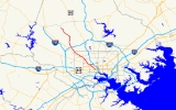
Maryland Route 129
Encyclopedia
Maryland Route 129 is a state highway
in the U.S. state
of Maryland
, running north-northwesterly from downtown Baltimore
into Baltimore County, ending east of Reisterstown. The route leaves downtown on the one-way pair
of McCulloh Street and Druid Hill Avenue, and then uses the entire length of Park Heights Avenue to the end.
)
Park Heights Avenue is also one of the boundaries of the famous Pimlico Race Course
, home of the Preakness Stakes
.
The entire route throughout Baltimore City has at least two travel lanes in each direction and parallel parking in most locations. For a short distance while passing Druid Hill Park, route 129 overlaps with Maryland Route 140
, also known as Reisterstown Road.
The route intersects with the Interstate 695, also known as the Baltimore Beltway, about one mile (1.6 km) north of the city line.
Streets near Pimlico Race Course
operates along Park Heights Avenue up to Slade Avenue. Route 58
also overlaps with Route 54 between Glen Avenue and Clarks Lane, and Route 97
(Mondawmin Shuttle Bug) also operates in a southbound direction only between Coldspring Lane and Park Circle.
Following the elimination of Route M-12 in October 2005, there was no public transportation on any part of Maryland Route 129 in Baltimore County until the introduction of Route 18
in 2010.
State highway
State highway, state road or state route can refer to one of three related concepts, two of them related to a state or provincial government in a country that is divided into states or provinces :#A...
in the U.S. state
U.S. state
A U.S. state is any one of the 50 federated states of the United States of America that share sovereignty with the federal government. Because of this shared sovereignty, an American is a citizen both of the federal entity and of his or her state of domicile. Four states use the official title of...
of Maryland
Maryland
Maryland is a U.S. state located in the Mid Atlantic region of the United States, bordering Virginia, West Virginia, and the District of Columbia to its south and west; Pennsylvania to its north; and Delaware to its east...
, running north-northwesterly from downtown Baltimore
Downtown Baltimore
Downtown Baltimore is the section of Baltimore traditionally bounded by Martin Luther King, Jr. Boulevard to the west, Mt. Royal Avenue to the north, President Street to the east and the Inner Harbor area to the south. It consists of four neighborhoods: Westside, City Centre, Inner Harbor, and...
into Baltimore County, ending east of Reisterstown. The route leaves downtown on the one-way pair
One-way pair
A one-way pair, one-way couple, or just couplet is a pair of parallel, usually one-way streets that carry opposite directions of a signed route or major traffic flow, or sometimes opposite directions of a bus or streetcar route....
of McCulloh Street and Druid Hill Avenue, and then uses the entire length of Park Heights Avenue to the end.
Baltimore City
Maryland Route 129, in Baltimore City, passes through or near many historic neighborhoods. These include Upton, Bolton Hill, Reservoir Hill, Pimlico, and Park Heights. The route is mostly lined with rowhouses until it reaches Upper Park Heights, an area known for its single-family homes, duplexes, and luxury apartments and condos. (Fallstaff, BaltimoreFallstaff, Baltimore
Fallstaff is a neighborhood in the Upper Park Heights area of Northwest Baltimore, Maryland, and is one of the city's northwestern-most communities...
)
Park Heights Avenue is also one of the boundaries of the famous Pimlico Race Course
Pimlico Race Course
Pimlico Race Course is a horse racetrack in Baltimore, Maryland, most famous for hosting the Preakness Stakes. Its name is derived from the 1660s when English settlers named the area where the facility currently stands in honor of Olde Ben Pimlico's Tavern in London...
, home of the Preakness Stakes
Preakness Stakes
The Preakness Stakes is an American flat Thoroughbred horse race for three-year-olds held on the third Saturday in May each year at Pimlico Race Course in Baltimore, Maryland. It is a Grade I race run over a distance of 9.5 furlongs on dirt. Colts and geldings carry 126 pounds ; fillies 121 lb...
.
The entire route throughout Baltimore City has at least two travel lanes in each direction and parallel parking in most locations. For a short distance while passing Druid Hill Park, route 129 overlaps with Maryland Route 140
Maryland Route 140
Maryland Route 140 is a local long route in northern Maryland, United States.-Route description:MD 140 is known by various names depending on location; south of Reisterstown it is known as Reisterstown Road. Though Reisterstown itself is named after John Reister, the road is named after Jacob...
, also known as Reisterstown Road.
Baltimore County
When Maryland Route 129 reaches the city/county line after Seven Mile Lane then at Slade Avenue, the road narrows into one travel lane in each direction, plus occasional turn lanes. From this point until its terminus at Garrison Forest Road in Owings Mills, the road is lined with upscale communities and undeveloped land.The route intersects with the Interstate 695, also known as the Baltimore Beltway, about one mile (1.6 km) north of the city line.
Major landmarks
The following well-known landmarks can be found along Maryland Route 129:- Druid Hill ParkDruid Hill ParkDruid Hill Park is a urban park in northwest Baltimore, Maryland. Its boundaries are marked by Druid Park Drive , Swann Drive and Reisterstown Road , and the Jones Falls Expressway...
and the Maryland Zoo - Pimlico Race TrackPimlico Race CoursePimlico Race Course is a horse racetrack in Baltimore, Maryland, most famous for hosting the Preakness Stakes. Its name is derived from the 1660s when English settlers named the area where the facility currently stands in honor of Olde Ben Pimlico's Tavern in London...
- Baltimore Hebrew UniversityBaltimore Hebrew UniversityBaltimore Hebrew University was founded as Baltimore Hebrew College and Teachers Training School in 1919 to promote Jewish scholarship and academic excellence, it continues to be the only institution of higher learning in Maryland devoted solely to all aspects of Judaic and Hebraic studies...
- Suburban Country Club
- Druid Ridge Cemetery
- "Synagogue Row": A number of synagogues and a Jewish Community CenterJewish Community CenterA Jewish Community Center or Jewish Community Centre is a general recreational, social and fraternal organization serving the Jewish community in a number of cities...
are clustered near each other near the start of Route 129. These include: - Temple Oheb Shalom, in a building designed by Walter GropiusWalter GropiusWalter Adolph Georg Gropius was a German architect and founder of the Bauhaus School who, along with Ludwig Mies van der Rohe and Le Corbusier, is widely regarded as one of the pioneering masters of modern architecture....
Streets near Pimlico Race Course
- Glen Avenue
- Cross Country Boulevard
- Pimlico Road and Greenspring AvenueGreenspring AvenueGreenspring Avenue is a road in Baltimore, Maryland and its northwestern suburbs. At one time, Greenspring Avenue was Maryland Route 519 from Worthington Road to Dover Road, but the road has since been decommissioned and no longer has any numerical designation....
Public transportation
In Baltimore City, there is plenty of public transportation along Maryland Route 129. Along Druid Hill Avenue/McCulloh Street, bus service is provided by Route 5. Route 54Route 54 (MTA Maryland)
Route 54 is a bus route that operates in Baltimore and its suburbs, serving the corridors of Park Heights Avenue, Milford Mill Road, and Liberty Road. All trips operate from the Penn-North Metro Subway Station in Baltimore City to the Milford Mill Metro Subway Station in Pikesville. From there,...
operates along Park Heights Avenue up to Slade Avenue. Route 58
Route 58 (MTA Maryland)
Route 58 is a bus route operated by the Maryland Transit Administration in Baltimore and its suburbs. The line's western terminus is the Reisterstown Plaza Metro Subway Station, and its eastern terminus is White Marsh Mall, though some peak hour trips make short turns in Overlea....
also overlaps with Route 54 between Glen Avenue and Clarks Lane, and Route 97
Route 97 (MTA Maryland)
Route 97, also known as the Mondawmin Shuttle Bug or Mondawmin Shuttle, is one of two neighborhood shuttle routes operated by the Maryland Transit Administration in Baltimore. It was the second and is so far the final in the series of shuttle bugs to be introduced in the 2000s...
(Mondawmin Shuttle Bug) also operates in a southbound direction only between Coldspring Lane and Park Circle.
Following the elimination of Route M-12 in October 2005, there was no public transportation on any part of Maryland Route 129 in Baltimore County until the introduction of Route 18
Route 18 (MTA Maryland)
Route 18 is a school-day only bus route operated by the Maryland Transit Administration in Baltimore. The line currently runs from Glen Avenue & Key Avenue in Northwest Baltimore to Smith Avenue & Copper Ridge Rd in Mount Washington or Old Court Road & Scotts Hill Dr in Pikesville or Park Heights...
in 2010.
Junction list
| County | Location | Mile | Intersection | Notes |
|---|---|---|---|---|
| Baltimore City (7.44 mi) |
0.00 |   US 40 (Franklin Street); MD 295 south (Paca Street; Greene Street) US 40 (Franklin Street); MD 295 south (Paca Street; Greene Street) |
US 40 east (Mulberry Street) is one block south on MD 295. | |
| 0.32 | Martin Luther King Jr. Boulevard | |||
| 1.40 |    US 1/US 40 Truck (North Avenue) US 1/US 40 Truck (North Avenue) |
|||
| 2.44 | Liberty Heights Avenue (to MD 26 west); Greenspring Avenue Greenspring Avenue Greenspring Avenue is a road in Baltimore, Maryland and its northwestern suburbs. At one time, Greenspring Avenue was Maryland Route 519 from Worthington Road to Dover Road, but the road has since been decommissioned and no longer has any numerical designation.... |
|||
| 2.72 |  MD 140 south (Reisterstown Road) MD 140 south (Reisterstown Road) |
MD 140 overlap begins | ||
| 2.93 | MD 140 north (Reisterstown Road) |
MD 140 overlap ends | ||
| 5.44 | Northern Parkway Northern Parkway (Baltimore) Northern Parkway is a major road that runs west–east across the northern part of the city Baltimore. For most of the way, it is at least six lanes wide, and it is used by motorists for crosstown travel.... |
|||
| Baltimore (7.99 mi) |
8.11 |  MD 133 east (Old Court Road) MD 133 east (Old Court Road) |
||
| 8.81 |  MD 129A east (Brooks Robinson Drive) to I-695 inner MD 129A east (Brooks Robinson Drive) to I-695 inner |
|||
| 8.85 |  I-695 outer I-695 outer |
Exit 21 of I-695 | ||
| 10.42 |  MD 130 (Greenspring Valley Road) MD 130 (Greenspring Valley Road) |
|||
| 15.43 | Garrison Forest Road | |||