

Manhattan Avenue
Encyclopedia
Brooklyn
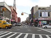
Manhattan Avenue is a north-south thoroughfare in the BrooklynBrooklyn
Brooklyn is the most populous of New York City's five boroughs, with nearly 2.6 million residents, and the second-largest in area. Since 1896, Brooklyn has had the same boundaries as Kings County, which is now the most populous county in New York State and the second-most densely populated...
neighborhoods of Greenpoint
Greenpoint, Brooklyn
Greenpoint is the northernmost neighborhood in the New York City borough of Brooklyn. It is bordered on the southwest by Williamsburg at the Bushwick inlet, on the southeast by the Brooklyn-Queens Expressway and East Williamsburg, on the north by Newtown Creek and Long Island City, Queens at the...
and Williamsburg
Williamsburg, Brooklyn
Williamsburg is a neighborhood in the New York City borough of Brooklyn, bordering Greenpoint to the north, Bedford-Stuyvesant to the south, Bushwick to the east and the East River to the west. The neighborhood is part of Brooklyn Community Board 1. The neighborhood is served by the NYPD's 90th ...
. It is the major shopping street in Greenpoint while it is mostly residential in Williamsburg. The stretch through Greenpoint is also called Little Poland
Little Poland, Brooklyn
Little Poland is an informal name for part of a neighborhood in Greenpoint, in the New York City borough of Brooklyn. The name "Little Poland" came to be applied to it following an influx of Polish immigrants after 1900...
for its high concentration of Polish culture and of Polish-named businesses and signage. The northern end was formerly connected to Long Island City, Queens
Queens
Queens is the easternmost of the five boroughs of New York City. The largest borough in area and the second-largest in population, it is coextensive with Queens County, an administrative division of New York state, in the United States....
by the Vernon Boulevard Bridge across Newtown Creek
Newtown Creek
Newtown Creek is a estuary that forms part of the border between the boroughs of Brooklyn and Queens, in New York City, New York, United States. It derives its name from New Town , which was the name for the Dutch and British settlement in what is now Elmhurst, Queens...
and the southern end is at Broadway
Broadway (Brooklyn)
Broadway is an avenue in the New York City borough of Brooklyn that extends from the East River in the neighborhood of Williamsburg in a southeasterly direction to East New York for a length of 4.32 miles . It was named for Broadway in Manhattan. The East New York terminus is a complicated...
. The southern part of the avenue is one way north bound while the portion in Greenpoint is two-way. The IND Crosstown Line
IND Crosstown Line
-External links:*...
subway runs under Manhattan Avenue north of McCarren Park
McCarren Park
McCarren Park is a public park in New York City, USA. It is located in the Greenpoint neighborhood of Brooklyn, and is bordered by Nassau Avenue, Bayard Street, Lorimer Street and North 12th Street...
.
Manhattan
Not included in the original Commissioners' Plan of 1811Commissioners' Plan of 1811
The Commissioners' Plan of 1811 was the original design plan for the streets of Manhattan, which put in place the grid plan that has defined Manhattan to this day....
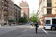
, Manhattan Avenue in Manhattan Valley
Manhattan Valley
Manhattan Valley is a neighborhood on the Upper West Side of Manhattan in New York City, bounded by West 110th Street to the north, Central Park West to the east, West 96th Street to the south, and Broadway to the west...
saw its first buildings in 1885, a group of row houses
Terraced house
In architecture and city planning, a terrace house, terrace, row house, linked house or townhouse is a style of medium-density housing that originated in Great Britain in the late 17th century, where a row of identical or mirror-image houses share side walls...
on its western side. These buildings were brick with stone and terra-cotta trim. The now defunct New York Cancer Hospital
New York Cancer Hospital
The New York Cancer Hospital in New York City was a cancer treatment and research institution founded in 1884 . The hospital was located at 455 Central Park West between 105th St and 106th St...
, a landmark since 1976 is nearby on Central Park West
Central Park West
Central Park West is an avenue that runs north-south in the New York City borough of Manhattan, in the United States....
.
Historic Districts
Manhattan Avenue between West 120th and 123rd Streets was designated a National Historic DistrictNational Historic District
National Historic District may refer to a historic district designated by a national government, including:* a historic district listed on the United States National Register of Historic Places * a United States National Historic Landmark District...
in 1992. The Manhattan Avenue/West 120th-123rd Streets Historic District lies on the western edge of Central Harlem. It is composed of 113 contributing brownstone and brick row houses on 4 short blocks between 120th and 123rd streets bounded by Morningside and Manhattan Avenues.
A Manhattan Avenue Historic District between West 105th & West 106th Streets, including 101-137 and 120-140 Manhattan Avenue was designated by the New York City Landmarks Preservation Commission
New York City Landmarks Preservation Commission
The New York City Landmarks Preservation Commission is the New York City agency charged with administering the city's Landmarks Preservation Law. The Commission was created in April 1965 by Mayor Robert F. Wagner following the destruction of Pennsylvania Station the previous year to make way for...
on May 15, 2007.