

Mangere Bridge
Encyclopedia
Manukau Harbour
Manukau Harbour is the second largest natural harbour in New Zealand by area. It is located to the southwest of the Auckland isthmus, and is an arm of the Tasman Sea.-Geography:...
in south-western Auckland
Auckland
The Auckland metropolitan area , in the North Island of New Zealand, is the largest and most populous urban area in the country with residents, percent of the country's population. Auckland also has the largest Polynesian population of any city in the world...
, New Zealand
New Zealand
New Zealand is an island country in the south-western Pacific Ocean comprising two main landmasses and numerous smaller islands. The country is situated some east of Australia across the Tasman Sea, and roughly south of the Pacific island nations of New Caledonia, Fiji, and Tonga...
, crossing between the suburb also known as Mangere Bridge
Mangere Bridge, New Zealand
Mangere Bridge can refer to two places in New Zealand:*Mangere Bridge, New Zealand, a suburb of Auckland City*Mangere Bridge , the bridges that gave the suburb its name...
(southern side) and the suburb of Onehunga
Onehunga
Onehunga is a suburb of Auckland City, New Zealand and the location of the Port of Onehunga, the city's small port on the Manukau Harbour. It is eight kilometres south of the city centre, close to the volcanic cone of One Tree Hill, Maungakiekie....
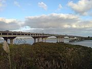
(northern side). Completed in 1983, the current bridge carries a four-lane motorway (carrying approximately 80,000 vehicles daily) with a cycle and pedestrian path also suspended underneath the western side of the bridge.
In April 2008, work began on a duplication of the bridge to cater for increased traffic (completed in 2010), and to serve up to 160,000 vehicles per day in 2021). The process was being delayed by disagreements over design and funding, as well as over the scope of the bridge project and an associated interchange - with the interchange being scaled down after concerns from the local community.
Original bridges
Initial bridgeThe initial bridge in this location was built of timber and opened in January 1875. Rather narrow, it also soon began to be attacked by shipworm
Shipworm
Shipworms are not worms at all, but rather a group of unusual saltwater clams with very small shells, notorious for boring into wooden structures that are immersed in sea water, such as piers, docks and wooden ships...
s, and in 1910, more than 30 of the piles had been replaced, as well as the decking. The bridge was also single-lane, and so narrow, even pedestrians could barely pass a vehicle safely. The bridge was eventually considered structurally unsound and closed in 1914, before being fully demolished.
Old Mangere Bridge
In January 1914 (according to some sources, only in 1915), a 246 m long replacement bridge was opened instead. Designed by R.F. Moore, the designer of Grafton Bridge
Grafton Bridge
Grafton Bridge is a road bridge spanning Grafton Gully in Auckland City, New Zealand. Built of reinforced concrete in 1910, it connects the Auckland CBD with the Grafton suburb...
, it was also built by the same company, the Ferro-Concrete Company of Australasia (in a time when almost all bridges in the country were being built by the Public Works Department). The ferro-concrete bridge with driven concrete piles was considered a substantial engineering achievement in its time. With a width of 11.6m, it allowed for a double tram track. The bridge however did not provide for enough clearance to let anything but small boats pass under it. In World War II, an anti-tank road block was erected on the bridge near the middle of the spans, with a small sentry shelter close by. The structure has since been removed, and it is unclear whether the bridge had also been mined.
However, the new bridge also soon proved to have too little capacity, and sinking foundation piles created issues. The old bridge was closed in the 1970s to motor vehicles and is slowly deteriorating as of today, especially after it sustained damage when a ship accidentally rammed it some years ago. A second ship, the 300 ft container transport Spirit of Resolution, also crashed into the old bridge on 8 October 2005 as it attempted to leave a nearby Port of Onehunga berth during winds estimated later on as being between 30-40 knots (with stronger gusts) and against a strong incoming tide. The collision occurred despite the ship's bow thruster
Bow thruster
A bow thruster is a transversal propulsion device built into, or mounted to, the bow of a ship or boat to make it more maneuverable. Bow thrusters make docking easier, since they allow the captain to turn the vessel to port or starboard without using the main propulsion mechanism which requires...
s working at full power and a small harbour tug
Tugboat
A tugboat is a boat that maneuvers vessels by pushing or towing them. Tugs move vessels that either should not move themselves, such as ships in a crowded harbor or a narrow canal,or those that cannot move by themselves, such as barges, disabled ships, or oil platforms. Tugboats are powerful for...
assisting.
As problems with the quality of the aging concrete and steel also make it unlikely that the 'Old Mangere Bridge' can be retained permanently, it was envisioned that the bridge would be dismantled and replaced by a newly designed footbridge. However, complaints about this course have for now (2006) stopped these plans while 'heritage options' are being considered as part of the general transport plans in the area. As of 2008, it is intended to retain the old bridge as a cycling / pedestrian link, and maintenance funds have been set aside for this continuing use.
Original Motorway Bridge
The current (as of 2009) Mangere Bridge was opened for traffic in 1983, and now carries approximately 80,000 vehicles a day. The motorway bridge had taken 8 years to build, due to labor and redundancy pay disputes which among other delays caused a stop to the work for 2 years.
Due to the limited capacity of the bridge, a duplication of the structure was decided on and eventually completed in 2010.
Bridge duplication
Project history
Initial fundingOn 17 May 2006 Finance Minister
Finance minister
The finance minister is a cabinet position in a government.A minister of finance has many different jobs in a government. He or she helps form the government budget, stimulate the economy, and control finances...
Michael Cullen announced in the Budget
Government budget
A government budget is a legal document that is often passed by the legislature, and approved by the chief executive-or president. For example, only certain types of revenue may be imposed and collected...
that funds were being allocated to Land Transport New Zealand, to help the National Land Transport Programme accelerate certain projects. This includes funds for duplicating of the 1983 bridge to its east. The Programme indicated that only $2.78 million funding was then approved for investigation of the project, though Transit New Zealand
Transit New Zealand
Transit New Zealand was, from 1989 to 2008, the New Zealand Crown entity responsible for operating and planning the New Zealand State Highway network...
might apply for additional $1.5 million for further investigation of this project in the current financial year. The bridge was at that time expected to cost NZ$330 million.
Wider area
As a wider part of the Manukau Harbour Crossing Project, the motorway is also to be widened between Walmsley Road in the south and Queenstown Road in the north from four lanes to six lanes. This widening will predominantly take place to the east of the existing motorway. The Onehunga interchange (known as the Gloucester Park Interchange) will be significantly reworked, to provide a more logical link with the motorway, and to ease congestion along Onehunga Harbour Drive. A standard diamond interchange
Diamond interchange
A diamond interchange is a common type of road junction, used where a freeway crosses a minor road. The freeway itself is grade-separated from the minor road, one crossing the other over a bridge...
was initially chosen by Transit, but after consultation with Auckland City
Auckland City
Auckland City was the city and local authority covering the Auckland isthmus and most of the islands of the Hauraki Gulf, in the North Island of New Zealand. On 1 November 2010 it was amalgamated into the wider Auckland Region under the authority of the new Auckland Council...
Council this was then reworked into a quarter-diamond design, with the northbound onramp hooking underneath a proposed Neilson Road bridge.
As part of that investigation, Transit did consider whether it would have been worthwhile to toll new capacity to assist in funding its construction. This could have been in the form of tolling the new lanes along this route, which would ensure an untolled alternative is available (as legally required), while the tolled new lanes would be far less congested. In mid 2007, Transit indicated that it would not seek a decision on funding the bridge via road toll
Road toll
Road toll is the term used in some countries for the number of deaths caused annually by road accidents.The term is in common and official use in Australia and New Zealand.-Australia:In Australia the road toll is reported at a state level...
s before starting work on construction. Auckland Airport had accused Transit of threatening to defer the project if it could not gain backing from the public and local Councils. As the bridge is to be finished for the 2011 Rugby World Cup, further delays would possibly have resulted in the bridge not being completed in time.
Public transport link
In early 2007 Transit indicated that it would be "more than willing" to develop a bridge that could also accommodate a rail link, intended for a possible future Auckland City
Auckland City
Auckland City was the city and local authority covering the Auckland isthmus and most of the islands of the Hauraki Gulf, in the North Island of New Zealand. On 1 November 2010 it was amalgamated into the wider Auckland Region under the authority of the new Auckland Council...
- Auckland Airport rail link using the Onehunga Branch, (which reopened for passenger traffic on 18 September 2010). The railway currently terminates near the northern end of the bridge. A combination solution was debated which would see a rail link use the same bridge foundations. The change came after repeated lobbying by the Auckland Regional Council
Auckland Regional Council
The Auckland Regional Council was the regional council of the Auckland Region. Its predecessor the Auckland Regional Authority was formed in 1963 and became the ARC in 1989...
, which was of the opinion that a previous provision - restricted to allowing space for an additional, but separate bridge - was not sufficient.
In September 2007, ARTA proposed to pledge NZ$ 2.5 million for future-proofing works which are to ensure that a rail link can be included in the future. The design envisages the future railway line run on the new bridge piers for part of the distance underneath the motorway structure, thus saving some of the high costs associated with strengthening the bridge to be able to take a cantilever
Cantilever
A cantilever is a beam anchored at only one end. The beam carries the load to the support where it is resisted by moment and shear stress. Cantilever construction allows for overhanging structures without external bracing. Cantilevers can also be constructed with trusses or slabs.This is in...
ed bridge - estimated at around NZ$ 20 million in extra costs. The bridge is already intended to accommodate bus shoulder lanes.
Interchange issues
In July 2007, Auckland City Council commissioners gave approval to widening the approach motorway for the bridge through Onehunga Bay
Onehunga
Onehunga is a suburb of Auckland City, New Zealand and the location of the Port of Onehunga, the city's small port on the Manukau Harbour. It is eight kilometres south of the city centre, close to the volcanic cone of One Tree Hill, Maungakiekie....
, but opposed the new interchange design north of the bridge as favoured by Transit, which intended to construct it around 7 m high over Gloucester Park and the Hopua volcanic tuff ring. A favoured version would instead be built in a cut and cover tunnel.
The recommendation, which Transit could have ignored only at the risk of drawn-out legal fights at the Environment Court level (which would be likely to delay the project until after the 2011 Rugby World Cup), was based on the concerns of residents, who fear that the new interchange would increase and cement separation of their suburb from the Manukau Harbour. Partly due to this, Transit New Zealand decided in August 2007 to continue with building the new bridge without including new interchange for the time being.
Final design
The new bridge will provide four southbound lanes and bus shoulder lanes (as many lanes as the existing bridge, which will become reserved for northbound traffic). One of the lanes will be dedicated to local connectivity between OnehungaOnehunga
Onehunga is a suburb of Auckland City, New Zealand and the location of the Port of Onehunga, the city's small port on the Manukau Harbour. It is eight kilometres south of the city centre, close to the volcanic cone of One Tree Hill, Maungakiekie....
and the Mangere Bridge suburb
Mangere Bridge, New Zealand
Mangere Bridge can refer to two places in New Zealand:*Mangere Bridge, New Zealand, a suburb of Auckland City*Mangere Bridge , the bridges that gave the suburb its name...
only. Transit New Zealand also confirmed that some provision will be made for a future rail link under both bridges to connect to Auckland Airport, with three of the eight piers constructed strong enough to carry a future rail link.
The bridge will have 7 piers with a total of 14 columns, and consist of approximately 10,000 cubic metres of reinforced concrete (with the rebar weighing approximately 1,000 tons). Some of the piles were driven 50m deep, to avoid issues with the softer top layers in the Manukau Harbour. The bridge itself consists of single-pour concrete columns and form traveller-constructed balanced cantilever decks.
The related works also include a widening of approximately 4km of associated motorway to ensure the new bridge capacity can be utilised. Existing pedestrian and cyclist links (on the old Mangere Bridge closed to motor vehicles) will be maintained and connected to a shared path along the Mangere Bridge waterfront reserve, via a new walking/cycling bridge over Onehunga Harbour Road - to link Onehunga to the existing walking and cycling route to Mangere Bridge suburb (over the 1914 bridge) and to the Waikaraka Cycleway
Waikaraka Cycleway
The Waikaraka Cycleway is an off-road cycleway in the south of Auckland City, New Zealand, running from the Wesley suburb in southern Auckland City along New Zealand State Highway 20 to Onehunga and then continuing along the shoreline of the Manukau Harbour beside mostly industrialised areas until...
.
Construction
Construction of the new bridge officially began on 9 April 2008, undertaken by the MHX Alliance, a combination of the NZTANew Zealand Transport Agency
The New Zealand Transport Agency is a New Zealand Crown entity tasked with promoting safe and functional transport by land, including the responsibility for driver and vehicle licensing and investigating rail accidents. It was created on 1 August 2008 by the Land Transport Management Amendment...
, Beca Infrastructure
Beca Group
' is one of the largest employee-owned engineering and related consultancy services companies in the Asia-Pacific. While it is headquartered in Auckland, New Zealand, Beca operates from three main hubs: Australia, New Zealand and Singapore. Beca has over 2,400 employees in total, many of them...
, Fletcher Construction
Fletcher Construction
Fletcher Construction Limited is a leading New Zealand construction company. It is owned by Fletcher Building Limited and has three main divisions:*Building and interiors *South Pacific...
and Higgins Contractors. The construction work will, after expected completion of the new bridge in late 2010, also include a temporary closure of the old bridge for refurbishment works, with all works to be completed in early 2011. As of early 2009, total costs are expected to be NZ$ 230 million.
The bridge was officially opened on 25 July 2010, seven months ahead of schedule. This brings the number of traffic lanes available over the harbour to 10, 2 of them bus shoulder lanes.
Ancillary works
A number of works related to environmental mitigationEnvironmental mitigation
Environmental mitigation, compensatory mitigation, or mitigation banking, are terms used primarily by the United States government and the related environmental industry to describe projects or programs intended to offset known impacts to an existing historic or natural resource such as a stream,...
, post-project landscaping or improvement of non-motorway transport links are associated with the project (and either paid for or undertaken by NZTA). These include a 3.5m wide replacement foot/cycle bridge over Beachcroft Road, a new 3.5m wide foot/cycle bridge over Onehunga Harbour road at the Old Mangere Bridge, an upgraded underpass under the motorway connecting to Onehunga, as well as improved links to the walking and cycling paths along the harbour and motorway edges
Waikaraka Cycleway
The Waikaraka Cycleway is an off-road cycleway in the south of Auckland City, New Zealand, running from the Wesley suburb in southern Auckland City along New Zealand State Highway 20 to Onehunga and then continuing along the shoreline of the Manukau Harbour beside mostly industrialised areas until...
and improvements works on the Old Mangere Bridge causeway. After finishing work, NZTA will also reinstate their large construction staging site along the southern harbour front as an open space, "passive recreation" park with Pohutukawa.
See also
- Auckland Harbour BridgeAuckland Harbour BridgeThe Auckland Harbour Bridge is an eight-lane box truss motorway bridge over the Waitemata Harbour, joining St Marys Bay in Auckland with Northcote in North Shore City, New Zealand. The bridge is part of State Highway 1 and the Auckland Northern Motorway...
- Upper Harbour BridgeUpper Harbour BridgeThe Upper Harbour Bridge or Greenhithe Bridge is a motorway bridge , which spans over a reach of the Waitemata Harbour and connects Hobsonville and Greenhithe , New Zealand....
External links
- Manukau Harbour Crossing (official NZTA project website)