
Manantali
Encyclopedia
Manantali is a town
on the Bafing River
in the Kayes Region
of south-western Mali
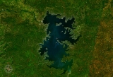
. East of the town is Lake Manantali
and its dam
.
Town
A town is a human settlement larger than a village but smaller than a city. The size a settlement must be in order to be called a "town" varies considerably in different parts of the world, so that, for example, many American "small towns" seem to British people to be no more than villages, while...
on the Bafing River
Bafing River
The Bafing River runs through Guinea and Mali and is about long. It joins with the Bakoy River in Bafoulabé to form the Sénégal River, in the Kayes Region of western Mali. It is also called the Black River while the Bakoy is called the White River...
in the Kayes Region
Kayes Region
Kayes Region is one of eight first level national subdivisions, called Regions in Mali. It is the first administrative area of Mali and covers an area of 120,760 km²...
of south-western Mali
Mali
Mali , officially the Republic of Mali , is a landlocked country in Western Africa. Mali borders Algeria on the north, Niger on the east, Burkina Faso and the Côte d'Ivoire on the south, Guinea on the south-west, and Senegal and Mauritania on the west. Its size is just over 1,240,000 km² with...
. East of the town is Lake Manantali
Lake Manantali
Lake Manantali is a large artificial lake, formed by the 1989 construction of the Manantali Dam, on the Bafing River in Mali. Its northern point is located 90 km to the south-east of the city of Bafoulabé.-Size:...
and its dam
Dam
A dam is a barrier that impounds water or underground streams. Dams generally serve the primary purpose of retaining water, while other structures such as floodgates or levees are used to manage or prevent water flow into specific land regions. Hydropower and pumped-storage hydroelectricity are...
.