
Lake Manantali
Encyclopedia
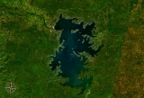
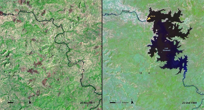
Lake Manantali is a large artificial lake
, formed by the 1989 construction of the Manantali Dam
, on the Bafing River
in Mali
. Its northern point is located 90 km to the south-east of the city of Bafoulabé
.
s, compromising traditional agriculture which depended upon seasonal flooding. The lake has created benefits as well: consistent navigation downstream of the dam, use of for irrigation of surrounding land, and a source for commercial fishing. The dam itself provides hydroelectric power through much of the region.
Lake
A lake is a body of relatively still fresh or salt water of considerable size, localized in a basin, that is surrounded by land. Lakes are inland and not part of the ocean and therefore are distinct from lagoons, and are larger and deeper than ponds. Lakes can be contrasted with rivers or streams,...
, formed by the 1989 construction of the Manantali Dam
Manantali Dam
The Manantali Dam is a multi-purpose dam on the Bafing river in the Senegal River basin, 90 km to the south-east of Bafoulabé, in Mali's Kayes Region.-History:...
, on the Bafing River
Bafing River
The Bafing River runs through Guinea and Mali and is about long. It joins with the Bakoy River in Bafoulabé to form the Sénégal River, in the Kayes Region of western Mali. It is also called the Black River while the Bakoy is called the White River...
in Mali
Mali
Mali , officially the Republic of Mali , is a landlocked country in Western Africa. Mali borders Algeria on the north, Niger on the east, Burkina Faso and the Côte d'Ivoire on the south, Guinea on the south-west, and Senegal and Mauritania on the west. Its size is just over 1,240,000 km² with...
. Its northern point is located 90 km to the south-east of the city of Bafoulabé
Bafoulabé
Bafoulabé is a town and commune in south-western Mali. It is located in the Region of Kayes. Bafoulabé is the capital of the Cercle of Bafoulabé, which in 1887 was the first Cercle to be created in Mali.-Local administration:...
.
Size
Lake Manantali covers 477 km² and contains 11.3 billion m³ of water. Its formation forced 12,000 people from their homes and flooded 120 km² of forest. The lake largely ended the flood patterns on both the Bafing and Senegal RiverSénégal River
The Sénégal River is a long river in West Africa that forms the border between Senegal and Mauritania.The Sénégal's headwaters are the Semefé and Bafing rivers which both originate in Guinea; they form a small part of the Guinean-Malian border before coming together at Bafoulabé in Mali...
s, compromising traditional agriculture which depended upon seasonal flooding. The lake has created benefits as well: consistent navigation downstream of the dam, use of for irrigation of surrounding land, and a source for commercial fishing. The dam itself provides hydroelectric power through much of the region.