
Kayes Region
Encyclopedia
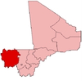
Regions of Mali
||Mali is divided into eight regions and one capital district. Each of the regions bears the name of its principal city. The regions are divided into 49 cercles. The cercles and the capital district are divided into 703 communes....
in Mali
Mali
Mali , officially the Republic of Mali , is a landlocked country in Western Africa. Mali borders Algeria on the north, Niger on the east, Burkina Faso and the Côte d'Ivoire on the south, Guinea on the south-west, and Senegal and Mauritania on the west. Its size is just over 1,240,000 km² with...
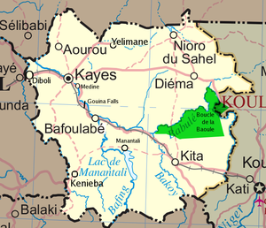
. It is the first administrative area of Mali and covers an area of 120,760 km². Its capital is the town of Kayes
Kayes
Kayes is a city in western Mali on the Sénégal River, with a population of roughly 100,000 people. Kayes is the capital of the administrative region of the same name. The name "Kayes" comes from the Soninké word "karré", which describes a low humid place that floods in rainy season...
.
Geography
The region of Kayes is bordered to the north by MauritaniaMauritania
Mauritania is a country in the Maghreb and West Africa. It is bordered by the Atlantic Ocean in the west, by Western Sahara in the north, by Algeria in the northeast, by Mali in the east and southeast, and by Senegal in the southwest...
, to the west by Senegal
Senegal
Senegal , officially the Republic of Senegal , is a country in western Africa. It owes its name to the Sénégal River that borders it to the east and north...
, to the south by Guinea
Guinea
Guinea , officially the Republic of Guinea , is a country in West Africa. Formerly known as French Guinea , it is today sometimes called Guinea-Conakry to distinguish it from its neighbour Guinea-Bissau. Guinea is divided into eight administrative regions and subdivided into thirty-three prefectures...
and to the east by the region of Koulikoro
Koulikoro Region
Koulikoro is a region in Mali. It is the second administrative area of Mali and covers an area of 90,120 km². Its capital is the city of Koulikoro.- Geography :...
.
In 2009 the region has a population of 1,996,812 inhabitants. Ethnic groups of the area include Soninkés, Khassonké
Khassonké
The Khassonké are an ethnic group of Mali's Kayes Region. Descendants of the Fula and Malinké Khasso kingdoms, they speak the Khassonke/Xaasongaxango language, a Manding language similar to Bambara....
s, Malinkés, and Fulas
Fula people
Fula people or Fulani or Fulbe are an ethnic group spread over many countries, predominantly in West Africa, but found also in Central Africa and Sudanese North Africa...
.
Several rivers cross the region: the Baoulé, the Bafing
Bafing River
The Bafing River runs through Guinea and Mali and is about long. It joins with the Bakoy River in Bafoulabé to form the Sénégal River, in the Kayes Region of western Mali. It is also called the Black River while the Bakoy is called the White River...
, and the Bakoy
Bakoy River
The Bakoy or Bakhoy River is a river in West Africa. It runs through Guinea and Mali and joins with the Bafing River to form the Sénégal River in Bafoulabé, in the Kayes Region of western Mali. It is also called the White River while the Bafing is called the Black River...
which join at the town of Bafoulabé
Bafoulabé
Bafoulabé is a town and commune in south-western Mali. It is located in the Region of Kayes. Bafoulabé is the capital of the Cercle of Bafoulabé, which in 1887 was the first Cercle to be created in Mali.-Local administration:...
to form the Sénégal River
Sénégal River
The Sénégal River is a long river in West Africa that forms the border between Senegal and Mauritania.The Sénégal's headwaters are the Semefé and Bafing rivers which both originate in Guinea; they form a small part of the Guinean-Malian border before coming together at Bafoulabé in Mali...
. The Falls of Félou (4 km of Kayes), the Falls of Gouina
Gouina Falls
The Gouina Falls or Chutes de Gouina are on the Sénégal River in Mali between the towns of Bafoulabé and Diamou in the Kayes Region, where the river runs north from the Talari Gorges. They have been called the "Niagara falls of Mali". The river is about 500 m wide at this point, and drops...
(100 km to the south-east of Kayes on the Sénégal River), Talari Gorges
Talari Gorges
The Talari Gorges or Gorges de Talary are a series of gorges on the Sénégal River in Mali, between the towns of Bafoulabé and Galougo in the Kayes Region, at an altitude of about 75 meters or 249 feet above sea level. They are celebrated for their grandiose beauty. Downstream, to the...
, Lake Magui and Lake Doro are located in the region.
At the Guinean border, the climate is rather wet, but becomes Sudanian
Sudan (region)
The Sudan is the name given to a geographic region to the south of the Sahara, stretching from Western to Eastern Africa. The name derives from the Arabic bilâd as-sûdân or "land of the Blacks"...
and later Sahel
Sahel
The Sahel is the ecoclimatic and biogeographic zone of transition between the Sahara desert in the North and the Sudanian Savannas in the south.It stretches across the North African continent between the Atlantic Ocean and the Red Sea....
ian to the north.
The largest cities in the region are Kayes
Kayes
Kayes is a city in western Mali on the Sénégal River, with a population of roughly 100,000 people. Kayes is the capital of the administrative region of the same name. The name "Kayes" comes from the Soninké word "karré", which describes a low humid place that floods in rainy season...
, Nioro du Sahel
Nioro du Sahel
Nioro du Sahel often referred to as simply Nioro is a town and commune in the Kayes Region of western Mali, 241 km from the city of Kayes. It is located 275 miles north-west of the capital Bamako...
, Diéma
Diéma, Mali
Diéma is a rural commune and small town in the Cercle of Diéma in the Kayes Region of western Mali. Diéma is also the administrative center of the Diéma Cercle...
, Yélimané
Yélimané
Yélimané is a town and principal settlement of the commune of Guidimé in the Cercle of Yélimané in the Kayes Region of south-western Mali.-External links:*...
, Sadiola
Sadiola
Sadiola is a town and commune in western Mali, south of Kayes. It is home to the largest gold mine in West Africa, the Sadiola Gold Mine, operated by Anglogold-Ashanti. As of 1998 the commune had a population of 16,678....
, Bafoulabé
Bafoulabé
Bafoulabé is a town and commune in south-western Mali. It is located in the Region of Kayes. Bafoulabé is the capital of the Cercle of Bafoulabé, which in 1887 was the first Cercle to be created in Mali.-Local administration:...
, Kénébia and Kita
Kita, Mali
Kita is a town and commune in western Mali. It lies on the eastern slope of Mount Kita , known for its caves and rock paintings. Today, the city is known for its music, its annual Roman Catholic pilgrimage and its role as a processing center for the surrounding cotton- and peanut-growing region...
.
The Bafing National Park
Bafing National Park
The Bafing National Park lies in southern Mali. It was established on the 1st of July 2000. This site is 5000 km². Bafing National Park is the only protected area for chimpanzees within the Manding Plateau area. Woodlands dominate most of the landscape. Both Korofin and Wongo National Park ...
and the Boucle du Baoulé National Park
Boucle du Baoulé National Park
The Boucle du Baoulé National Park lies in western Mali, in Kayes Region and Koulikoro Region, set up in 1982. It has an area of 25,330 km² but has little large wildlife...
are located in the region.
Cercles
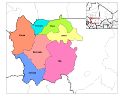
Cercles of Mali
A cercle is the second level administrative unit in Mali. Mali is divided into eight regions and one capital district . These subdivisions bear the name of their principal city. The regions are divided into 49 cercles....
:
- Bafoulabé CercleBafoulabé CercleBafoulabé Cercle is a second level administrative subdivision of the Kayes Region in western Mali. Its capital is the commune of Bafoulabé.The Cercle contains the following Rural and Urban Communes:*Bafoulabé *Bamafele *Diakon...
- Diéma CercleDiema CercleDiéma Cercle is an administrative subdivision of the Kayes Region of Mali. Its administrative center is the small town of Diéma. The Cercle is divided into one urban commune and fourteen rural communes...
- Kita CercleKita CercleKita Cercle is an administrative subdivision of the Kayes Region of Mali. Its capital is the city of Kita. The Cercle is further divided into Arrondissements and Communes. Kita Cercle's population as of 1998 was 278,111 people....
- Kéniéba CercleKenieba CercleKéniéba Cercle is an administrative subdivision of the Kayes Region of Mali. Its capital is the town of Kéniéba. The Cercle is further divided into Communes.Kéniéba Cercle includes the following communes:*Baye*Dabia*Dialafara*Dombia*Faléa*Faraba...
- Kayes CercleKayes CercleKayes Cercle is an administrative subdivision of the Kayes Region of Mali. Its seat is the city of Kayes, which is also the capital of its Region and its largest city. The Cercle is further divided into Arrondissements and Communes. Kayes city is subdivided into Urban Communes and Wards...
- Nioro Cercle
- Yélimané CercleYélimané CercleYélimané Cercle is an administrative subdivision of the Kayes Region of Mali. Its seat is the town of Yélimané. The Cercle is further divided into Communes...
History
The region of Kayes is the cradle of the Kingdom of KhassoKhasso
Khasso or Xaaso was a West African kingdom of the 17th to 19th centuries, occupying territory in what is today Senegal and the Kayes Region of Mali. Its capital was at Medina until its fall....
founded at the beginning of the 19th century.
In 1855, Louis Faidherbe
Louis Faidherbe
Louis Léon César Faidherbe was a French general and colonial administrator. He created the Senegalese Tirailleurs when he was governor of Senegal.- Background :...
, Governor of Senegal, built a fort at Medina
Siege of Medina Fort
The Siege of the Fort du Médine took place in 1857 at Médine near Kayes modern-day Mali, when the Toucouleur forces of al-Hājj Umar Taal unsuccessfully besieged French colonial troops under General Louis Faidherbe, governor of Senegal.-Origin:...
which would be besieged by El Hadj Omar Tall
Umar Tall
El Hadj Umar ibn Sa'id Tall , , born in what is now actual Senegal was a West African political leader, Islamic scholar, and Toucouleur military commander who founded a brief empire encompassing much of what is now Guinea, Senegal, and Mali.-Name:Umar Tall's name is spelled variously: in...
, in an 1857 war against the sovereign of Khasso. In 1892, the town of Kayes
Kayes
Kayes is a city in western Mali on the Sénégal River, with a population of roughly 100,000 people. Kayes is the capital of the administrative region of the same name. The name "Kayes" comes from the Soninké word "karré", which describes a low humid place that floods in rainy season...
became the capital of French Sudan
French Sudan
French Sudan was a colony in French West Africa that had two separate periods of existence, first from 1890 to 1899, then from 1920 to 1960, when the territory became the independent nation of Mali.-Colonial establishment:...
.
The construction of the railway line of Dakar-Niger, inaugurated in 1904, made of Kayes a city-crossroads. Essential at the time, the railroad had an important place in the lives of the inhabitants, as described in Ousmane Sembène
Ousmane Sembène
Ousmane Sembène , often credited in the French style as Sembène Ousmane in articles and reference works, was a Senegalese film director, producer and writer...
's novel God's Bits of Wood.