

Malaguni River
Encyclopedia
Nullah
A Nullah or Nulla is an arm of the sea, stream, or watercourse, a steep narrow valley. Like the wadi of the Arabs, the nullah is characteristic of mountainous or hilly country where there is little rainfall...
or hill stream
Stream
A stream is a body of water with a current, confined within a bed and stream banks. Depending on its locale or certain characteristics, a stream may be referred to as a branch, brook, beck, burn, creek, "crick", gill , kill, lick, rill, river, syke, bayou, rivulet, streamage, wash, run or...
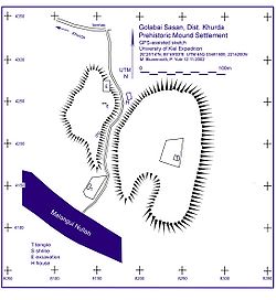
in Khurda District, Orissa
Orissa
Orissa , officially Odisha since Nov 2011, is a state of India, located on the east coast of India, by the Bay of Bengal. It is the modern name of the ancient nation of Kalinga, which was invaded by the Maurya Emperor Ashoka in 261 BC. The modern state of Orissa was established on 1 April...
state of India
India
India , officially the Republic of India , is a country in South Asia. It is the seventh-largest country by geographical area, the second-most populous country with over 1.2 billion people, and the most populous democracy in the world...
. It originates on the border of Ganjam District
Ganjam District
Ganjam district is a district in the Indian state of Orissa located on the border of Andhra Pradesh. Ganjam's total area is 8,070 km² . Its population is approximately 2,704,056.Ganjam is known for its beaches bordering the Bay of Bengal, the most famous ones being Gopalpur and Dhavaleshwar...
and Khurda District. It flows northeast, east and southeast through Khurda Tahasil, passes historic Golabai Sassan
Golabai
Golabai Sasan is a village in Khurda District, Orissa, India at .It is known for its medieval temple architecture. This settlement site is located on the north bank of the Malaguni River, North of Chilika lake....
and joins the Daya River
Daya River
The Daya River starts as a branch of the Kuakhai River at Saradeipur in Orissa state in India. It is joined by the Malaguni River below Golabai and flows through Khordha and Puri districts before emptying into the north-eastern corner of Chilika Lake, km from its origin.The historically important...
at 20°0′1"N 85°37′30"E, 1 km (0.621372736649807 mi) north of Balabhadrapur village in Puri District
Puri District
Puri being a coastal district of Orissa, is famous for its Historic antiquities, Religious sanctuaries, Architectural Grandeur, Sea-scape beauty,moderate climate.It holds a wealth of attraction for the visitors. It boasts of a continuous history from the 3rd Century B.C...
. The Daya then flows southwest into Chilika Lake, which then flows to the Bay of Bengal
Bay of Bengal
The Bay of Bengal , the largest bay in the world, forms the northeastern part of the Indian Ocean. It resembles a triangle in shape, and is bordered mostly by the Eastern Coast of India, southern coast of Bangladesh and Sri Lanka to the west and Burma and the Andaman and Nicobar Islands to the...
.
There is a Minor Irrigation project constructed on it near Rameswar village. When it floods, some portions of Khurda, Chilika and Tangi blocks are badly affected.