

Maize, Kansas
Encyclopedia
Maize is a city in Sedgwick County
, Kansas
, United States
. It is a suburb
of Wichita
. As of the 2010 census, the city population was 3,420.
as a city.
Several natural disasters struck Maize in the 1930s and 1940s, including the Dust Bowl
in 1934-35, a plague of grasshopper
s in 1936, and a flood in 1944.
Maize began to grow rapidly in 1950, more than doubling in size by 1956. This growth has continued, accelerating in recent years as Wichita has expanded to the northwest, and transformed Maize into a suburb.
in the Wellington-McPherson Lowlands region of the Great Plains
. Located in south-central Kansas, Maize is on K-96
immediately northwest of Wichita
.
According to the United States Census Bureau
, the city has a total area of 0.8 square miles (2.1 km²), all of it land.
of 2000, there were 1,868 people, 632 households, and 523 families residing in the city. The population density
was 2,274.9 people per square mile (879.6/km²). There were 668 housing units at an average density of 813.5 per square mile (314.5/km²). The racial makeup of the city was 93.47% White, 0.96% African American, 1.23% Native American, 0.32% Asian, 0.91% from other races
, and 3.10% from two or more races. Hispanic or Latino of any race were 2.62% of the population.
There were 632 households out of which 49.4% had children under the age of 18 living with them, 66.6% were married couples
living together, 11.4% had a female householder with no husband present, and 17.2% were non-families. 15.7% of all households were made up of individuals and 6.0% had someone living alone who was 65 years of age or older. The average household size was 2.96 and the average family size was 3.28.
In the city the population was spread out with 34.4% under the age of 18, 8.0% from 18 to 24, 30.7% from 25 to 44, 19.9% from 45 to 64, and 7.1% who were 65 years of age or older. The median age was 30 years. For every 100 females there were 100.4 males. For every 100 females age 18 and over, there were 97.1 males.
The median income for a household in the city was $51,845, and the median income for a family was $53,365. Males had a median income of $41,653 versus $25,817 for females. The per capita income
for the city was $18,803. About 1.9% of families and 3.0% of the population were below the poverty line, including 4.4% of those under age 18 and 1.4% of those age 65 or over.
form of government. The city council
consists of the mayor
and five members who serve part-time. The mayor is elected to a four-year term while terms for council members are staggered such that two members are up for election every two years.
266 operates ten schools in and around the city:
runs southeast-northwest along the northeast side of the city.
The Hutchinson line of the Kansas and Oklahoma Railroad
runs southeast-northwest through Maize.
Maize Airport
is a privately owned, public-use airport
located two nautical mile
s (2.3 mi
, 3.7 km
) southeast of the central business district
of Maize.
Schools
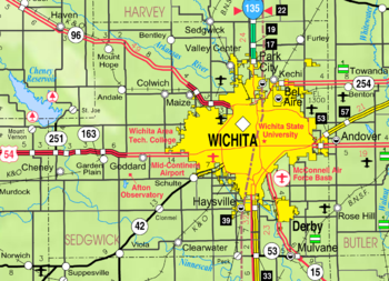
Maps
Sedgwick County, Kansas
Sedgwick County is a county located in the U.S. state of Kansas. The county's population was 498,365 for the 2010 census. The largest city and county seat is Wichita. The county was named after General John Sedgwick...
, Kansas
Kansas
Kansas is a US state located in the Midwestern United States. It is named after the Kansas River which flows through it, which in turn was named after the Kansa Native American tribe, which inhabited the area. The tribe's name is often said to mean "people of the wind" or "people of the south...
, United States
United States
The United States of America is a federal constitutional republic comprising fifty states and a federal district...
. It is a suburb
Suburb
The word suburb mostly refers to a residential area, either existing as part of a city or as a separate residential community within commuting distance of a city . Some suburbs have a degree of administrative autonomy, and most have lower population density than inner city neighborhoods...
of Wichita
Wichita, Kansas
Wichita is the largest city in the U.S. state of Kansas.As of the 2010 census, the city population was 382,368. Located in south-central Kansas on the Arkansas River, Wichita is the county seat of Sedgwick County and the principal city of the Wichita metropolitan area...
. As of the 2010 census, the city population was 3,420.
History
The Maize Town Company, led by N. F. Neiderlander, founded Maize in 1886 at the first stop outside of Wichita on the Wichita and Colorado Railway. The post office opened that same year as did the town's first church, having relocated from nearby. Maize's first school opened in 1887; its first newspaper opened in 1895. Maize State Bank, the town's first financial institution, opened in 1901, and, by 1908, a business community had emerged. In 1915, the Maize Town Company dissolved, and Maize was incorporatedMunicipal corporation
A municipal corporation is the legal term for a local governing body, including cities, counties, towns, townships, charter townships, villages, and boroughs. Municipal incorporation occurs when such municipalities become self-governing entities under the laws of the state or province in which...
as a city.
Several natural disasters struck Maize in the 1930s and 1940s, including the Dust Bowl
Dust Bowl
The Dust Bowl, or the Dirty Thirties, was a period of severe dust storms causing major ecological and agricultural damage to American and Canadian prairie lands from 1930 to 1936...
in 1934-35, a plague of grasshopper
Grasshopper
The grasshopper is an insect of the suborder Caelifera in the order Orthoptera. To distinguish it from bush crickets or katydids, it is sometimes referred to as the short-horned grasshopper...
s in 1936, and a flood in 1944.
Maize began to grow rapidly in 1950, more than doubling in size by 1956. This growth has continued, accelerating in recent years as Wichita has expanded to the northwest, and transformed Maize into a suburb.
Geography
Maize is located at 37°46′45"N 97°28′2"W (37.779178, -97.467267) at an elevation of 1,348 feet (411 m). It lies on the west side of Big Slough Creek roughly 3 miles (4.8 km) southwest of the Arkansas RiverArkansas River
The Arkansas River is a major tributary of the Mississippi River. The Arkansas generally flows to the east and southeast as it traverses the U.S. states of Colorado, Kansas, Oklahoma, and Arkansas. The river's initial basin starts in the Western United States in Colorado, specifically the Arkansas...
in the Wellington-McPherson Lowlands region of the Great Plains
Great Plains
The Great Plains are a broad expanse of flat land, much of it covered in prairie, steppe and grassland, which lies west of the Mississippi River and east of the Rocky Mountains in the United States and Canada. This area covers parts of the U.S...
. Located in south-central Kansas, Maize is on K-96
K-96 (Kansas highway)
K-96 is a state highway in central and southern Kansas. Its western terminus is at the Colorado state line east of Towner, Colorado, where it continues as Colorado State Highway 96; its eastern terminus since 1999 is at U.S. Route 54/U.S. Route 400 east of Wichita.The eastern terminus was once at...
immediately northwest of Wichita
Wichita, Kansas
Wichita is the largest city in the U.S. state of Kansas.As of the 2010 census, the city population was 382,368. Located in south-central Kansas on the Arkansas River, Wichita is the county seat of Sedgwick County and the principal city of the Wichita metropolitan area...
.
According to the United States Census Bureau
United States Census Bureau
The United States Census Bureau is the government agency that is responsible for the United States Census. It also gathers other national demographic and economic data...
, the city has a total area of 0.8 square miles (2.1 km²), all of it land.
Demographics
As of the censusCensus
A census is the procedure of systematically acquiring and recording information about the members of a given population. It is a regularly occurring and official count of a particular population. The term is used mostly in connection with national population and housing censuses; other common...
of 2000, there were 1,868 people, 632 households, and 523 families residing in the city. The population density
Population density
Population density is a measurement of population per unit area or unit volume. It is frequently applied to living organisms, and particularly to humans...
was 2,274.9 people per square mile (879.6/km²). There were 668 housing units at an average density of 813.5 per square mile (314.5/km²). The racial makeup of the city was 93.47% White, 0.96% African American, 1.23% Native American, 0.32% Asian, 0.91% from other races
Race (United States Census)
Race and ethnicity in the United States Census, as defined by the Federal Office of Management and Budget and the United States Census Bureau, are self-identification data items in which residents choose the race or races with which they most closely identify, and indicate whether or not they are...
, and 3.10% from two or more races. Hispanic or Latino of any race were 2.62% of the population.
There were 632 households out of which 49.4% had children under the age of 18 living with them, 66.6% were married couples
Marriage
Marriage is a social union or legal contract between people that creates kinship. It is an institution in which interpersonal relationships, usually intimate and sexual, are acknowledged in a variety of ways, depending on the culture or subculture in which it is found...
living together, 11.4% had a female householder with no husband present, and 17.2% were non-families. 15.7% of all households were made up of individuals and 6.0% had someone living alone who was 65 years of age or older. The average household size was 2.96 and the average family size was 3.28.
In the city the population was spread out with 34.4% under the age of 18, 8.0% from 18 to 24, 30.7% from 25 to 44, 19.9% from 45 to 64, and 7.1% who were 65 years of age or older. The median age was 30 years. For every 100 females there were 100.4 males. For every 100 females age 18 and over, there were 97.1 males.
The median income for a household in the city was $51,845, and the median income for a family was $53,365. Males had a median income of $41,653 versus $25,817 for females. The per capita income
Per capita income
Per capita income or income per person is a measure of mean income within an economic aggregate, such as a country or city. It is calculated by taking a measure of all sources of income in the aggregate and dividing it by the total population...
for the city was $18,803. About 1.9% of families and 3.0% of the population were below the poverty line, including 4.4% of those under age 18 and 1.4% of those age 65 or over.
Government
Maize has a mayor-council-administratorCouncil-manager government
The council–manager government form is one of two predominant forms of municipal government in the United States; the other common form of local government is the mayor-council government form, which characteristically occurs in large cities...
form of government. The city council
City council
A city council or town council is the legislative body that governs a city, town, municipality or local government area.-Australia & NZ:Because of the differences in legislation between the States, the exact definition of a City Council varies...
consists of the mayor
Mayor
In many countries, a Mayor is the highest ranking officer in the municipal government of a town or a large urban city....
and five members who serve part-time. The mayor is elected to a four-year term while terms for council members are staggered such that two members are up for election every two years.
Primary and secondary education
Maize USDUnified school district
A unified school district or unit school district is a school district which includes both primary school and high school under the same district control....
266 operates ten schools in and around the city:
- Early Childhood Center (Grades Pre-K)
- Maize Central Elementary School (K-5)
- Maize Elementary School (K-1)
- Maize South Elementary School (2-5)
- Pray-Woodman Elementary School (2-5)
- Maize Middle School (6-8)
- Maize South Middle School (6-8)
- Maize High SchoolMaize High SchoolMaize High School is a fully accredited public high school located in Maize, Kansas, USA, serving students in grades 9-12. The current principal is Mike Bonner. Maize High School is one of two high schools located within the city limits of Maize, Kansas. The school colors are red and white,...
(9-12) - Maize South High School (9-12)
- Complete High School Maize (9-12), alternative schoolAlternative schoolAlternative school is the name used in some parts of the world to describe an institution which provides part of alternative education. It is an educational establishment with a curriculum and methods that are nontraditional...
Infrastructure
Transportation
K-96K-96 (Kansas highway)
K-96 is a state highway in central and southern Kansas. Its western terminus is at the Colorado state line east of Towner, Colorado, where it continues as Colorado State Highway 96; its eastern terminus since 1999 is at U.S. Route 54/U.S. Route 400 east of Wichita.The eastern terminus was once at...
runs southeast-northwest along the northeast side of the city.
The Hutchinson line of the Kansas and Oklahoma Railroad
Kansas and Oklahoma Railroad
The Kansas and Oklahoma Railroad is a shortline railroad operating in the western United States.The tracks Kansas and Oklahoma operate on include the Kansas City-Colorado main line formerly operated by the Missouri Pacific and later Union Pacific railways....
runs southeast-northwest through Maize.
Maize Airport
Maize Airport
Maize Airport is a privately owned, public-use airport located two nautical miles southeast of the central business district of Maize, a city in Sedgwick County, Kansas, United States.- Facilities and aircraft :...
is a privately owned, public-use airport
Airport
An airport is a location where aircraft such as fixed-wing aircraft, helicopters, and blimps take off and land. Aircraft may be stored or maintained at an airport...
located two nautical mile
Nautical mile
The nautical mile is a unit of length that is about one minute of arc of latitude along any meridian, but is approximately one minute of arc of longitude only at the equator...
s (2.3 mi
Mile
A mile is a unit of length, most commonly 5,280 feet . The mile of 5,280 feet is sometimes called the statute mile or land mile to distinguish it from the nautical mile...
, 3.7 km
Kilometre
The kilometre is a unit of length in the metric system, equal to one thousand metres and is therefore exactly equal to the distance travelled by light in free space in of a second...
) southeast of the central business district
Central business district
A central business district is the commercial and often geographic heart of a city. In North America this part of a city is commonly referred to as "downtown" or "city center"...
of Maize.
Further reading
- History of the State of Kansas; William G. Cutler; A.T. Andreas Publisher; 1883. (Online HTML eBook)
- Kansas : A Cyclopedia of State History, Embracing Events, Institutions, Industries, Counties, Cities, Towns, Prominent Persons, Etc; 3 Volumes; Frank W. Blackmar; Standard Publishing Co; 944 / 955 / 824 pages; 1912. (Volume1 - Download 54MB PDF eBook),(Volume2 - Download 53MB PDF eBook), (Volume3 - Download 33MB PDF eBook)
External links
CitySchools
- USD 266, local school district
Maps
- Maize City Map, KDOT
- Sumner County Map, KDOT