

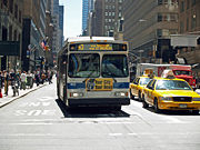
Madison and Fifth Avenues buses
Encyclopedia
New York City Transit Authority
The New York City Transit Authority is a public authority in the U.S. state of New York that operates public transportation in New York City...
operates several local bus routes on the one-way pair
One-way pair
A one-way pair, one-way couple, or just couplet is a pair of parallel, usually one-way streets that carry opposite directions of a signed route or major traffic flow, or sometimes opposite directions of a bus or streetcar route....
of Madison Avenue
Madison Avenue (Manhattan)
Madison Avenue is a north-south avenue in the borough of Manhattan in New York City, United States, that carries northbound one-way traffic. It runs from Madison Square to the Madison Avenue Bridge at 138th Street. In doing so, it passes through Midtown, the Upper East Side , Spanish Harlem, and...
(northbound) and Fifth Avenue
Fifth Avenue (Manhattan)
Fifth Avenue is a major thoroughfare in the center of the borough of Manhattan in New York City, New York, United States. The section of Fifth Avenue that crosses Midtown Manhattan, especially that between 49th Street and 60th Street, is lined with prestigious shops and is consistently ranked among...
(southbound) in Manhattan
Manhattan
Manhattan is the oldest and the most densely populated of the five boroughs of New York City. Located primarily on the island of Manhattan at the mouth of the Hudson River, the boundaries of the borough are identical to those of New York County, an original county of the state of New York...
, New York City, United States. The M1 Fifth and Madison Avenues, M2 Fifth and Madison Avenues/Powell Boulevard, M3 Fifth and Madison Avenues/St Nicholas Avenue, and M4 Fifth and Madison Avenues/Broadway run along the avenues from Midtown into Harlem, and several primarily east-west routes, including the Q32 Roosevelt/Fifth Avenues, use portions of them. Many express buses from the north or the south also use Fifth and Madison Avenues.
The routes are the successors to the New York and Harlem Railroad
New York and Harlem Railroad
The New York and Harlem Railroad was one of the first railroads in the United States, and possibly also the world's first street railway. Designed by John Stephenson, it was opened in stages between 1832 and 1852 between Lower Manhattan to and beyond Harlem...
's Fourth and Madison Avenues Line
Fourth and Madison Avenues Line
The Fourth and Madison Avenues Line is a public transit line in Manhattan, New York City, United States, running mostly along Park Avenue and Madison Avenue from Lower Manhattan to Harlem. Originally a streetcar line, it is now much of the M1 bus route, operated by the New York City Transit Authority...
, which began operations in 1832 as the first street railway in the world, and several lines of the Fifth Avenue Coach Company, a bus operator that started running on Fifth Avenue in 1886.
Description
The M1, M2, M3, and M4 all run between Midtown or Lower ManhattanLower Manhattan
Lower Manhattan is the southernmost part of the island of Manhattan, the main island and center of business and government of the City of New York...
and Upper Manhattan
Upper Manhattan
Upper Manhattan denotes the more northerly region of the New York City Borough of Manhattan. Its southern boundary may be defined anywhere between 59th Street and 155th Street. Between these two extremes lies the most common definitions of Upper Manhattan as Manhattan above 96th Street...
, while the Q32 runs from Midtown north along Fifth and Madison Avenues and east over the Queensboro Bridge
Queensboro Bridge
The Ed Koch Queensboro Bridge, also known as the 59th Street Bridge – because its Manhattan end is located between 59th and 60th Streets – or simply the Queensboro Bridge, is a cantilever bridge over the East River in New York City that was completed in 1909...
to Jackson Heights, Queens
Jackson Heights, Queens
Jackson Heights is a neighborhood in the Northwestern portion of the borough of Queens in New York, New York, United States. The neighborhood is part of Queens Community Board 3...
. The M1, M2, and M3 routes all turn around at Eighth Street
Eighth Street (Manhattan)
Eighth Street is a street in the New York City borough of Manhattan that runs from Sixth Avenue to Third Avenue, and Avenue B to Avenue D; it switches from west to east at Fifth Avenue. Between Third Avenue and Avenue A, the position in the grid that would be occupied by Eighth Street is known as...
. North of there, they use Fifth Avenue north of Eighth Street (southbound) and Park Avenue north of Union Square (northbound), switching to Madison Avenue at 25th Street (northbound). Weekend M1 service does not operate into Midtown, instead terminating at 106th Street.The M4 and Q32 begin at Penn Station, joining Madison Avenue at 32nd Street (northbound) and Fifth Avenue at 34th Street
34th Street (Manhattan)
34th Street is a major cross-town street in the New York City borough of Manhattan, connecting the Lincoln Tunnel and Queens-Midtown Tunnel. Like many of New York City's major crosstown streets, it has its own bus routes and four subway stops serving the trains at Eighth Avenue, the trains at...
(southbound). Thus, all five routes are on Fifth and Madison Avenues north of 34th Street.
The Q32 turns east on 59th Street
59th Street (Manhattan)
59th Street in the New York City borough of Manhattan runs east-west, from York Avenue to the West Side Highway, with a discontinuity between Ninth Avenue/Columbus Avenue and Eighth Avenue/Central Park West for the Time Warner Center. Although it is bi-directional for most of its length, the...
(eastbound) and 60th Street (westbound) to reach the Queensboro Bridge, On the other side, it heads east on Queens Boulevard
Queens Boulevard
Queens Boulevard is a major thoroughfare in the New York City boroughs of Manhattan and Queens connecting communities from Midtown Manhattan to Jamaica...
and Roosevelt Avenue
Roosevelt Avenue
Roosevelt Avenue is a main thoroughfare in the New York City borough of Queens. Roosevelt Avenue begins at 48th Street and Queens Boulevard in the neighborhood of Sunnyside...
to end at 81st and 82nd Streets and Northern Boulevard in Jackson Heights. The four other routes continue north on Fourth and Madison Avenues past Central Park. The M1 stays on those avenues to 135th Street, making several turns before turning around at Seventh Avenue
Seventh Avenue (Manhattan)
Seventh Avenue, known as Adam Clayton Powell Jr. Boulevard north of Central Park, is a thoroughfare on the West Side of the borough of Manhattan in New York City. It is southbound below Central Park and a two-way street north of the park....
and 146th and 147th Streets. The M2, M3, and M4 all turn west on 110th Street
110th Street (Manhattan)
110th Street is a street in the New York City borough of Manhattan. It is commonly known as the boundary between Harlem and Central Park, along which it is known as Central Park North. In the west, it is also known as Cathedral Parkway....
, turning north at various points. The M2 uses Seventh Avenue and Edgecombe Avenue, ending at Broadway and 168th Street. The M3 uses Manhattan Avenue
Manhattan Avenue
Manhattan Avenue is the name of two streets in New York City.-Brooklyn:Manhattan Avenue is a north-south thoroughfare in the Brooklyn neighborhoods of Greenpoint and Williamsburg. It is the major shopping street in Greenpoint while it is mostly residential in Williamsburg...
and St. Nicholas Avenue to Fort George, and the M4 uses Broadway and Fort Washington Avenue
Fort Washington Avenue (Manhattan)
Fort Washington Avenue is a major north-south street in the Washington Heights neighborhood of Manhattan. It runs from Fort Tryon Park to 159th Street, where it intersects with Broadway. It goes past Bennett Park, the highest natural point in Manhattan. Famous residents of Fort Washington Avenue...
to Fort Tryon Park
Fort Tryon Park
Fort Tryon Park is a public park located in the Washington Heights section of the borough of Manhattan in New York City, USA. It is situated on a 67 acre ridge in Upper Manhattan, with a commanding view of the Hudson River, the George Washington Bridge, the New Jersey Palisades and the Harlem River...
and the Cloisters
The Cloisters
The Cloisters is a museum located in Fort Tryon Park, New York City. The building, which is a branch of the Metropolitan Museum of Art, was reconstructed in the 1930s from the architectural elements of several European medieval abbeys...
. All buses connect with subway service at various points on their route.
The M2 runs as a limited-stop service, with no local service during the daytime. Other times, service runs local only. The M1 and M4 also have peak directional limited-stop services.
History
The Fifth Avenue Transportation CompanyFifth Avenue Transportation Company
The Fifth Avenue Transportation Company was a transportation company based in New York which was founded in 1885 and operated of horse-and-omninbus transit along Fifth Avenue, with a route running from 89th Street to Bleecker Street using horse-drawn omnibuses...
(later the Fifth Avenue Coach Company) began operating stage
Stagecoach
A stagecoach is a type of covered wagon for passengers and goods, strongly sprung and drawn by four horses, usually four-in-hand. Widely used before the introduction of railway transport, it made regular trips between stages or stations, which were places of rest provided for stagecoach travelers...
s on Fifth Avenue between 11th Street and 59th Street
59th Street (Manhattan)
59th Street in the New York City borough of Manhattan runs east-west, from York Avenue to the West Side Highway, with a discontinuity between Ninth Avenue/Columbus Avenue and Eighth Avenue/Central Park West for the Time Warner Center. Although it is bi-directional for most of its length, the...
on January 23, 1886. The company was formed because the wealthy residents of Fifth Avenue did not want a street railway. The route was later extended south to Washington Square Park and north to 89th Street
89th Street (Manhattan)
89th Street runs from Riverside Drive, overlooking the Hudson River, to the East River, through the New York City borough of Manhattan. The street is interrupted by Central Park...
, and in 1900 the company was authorized to extend north to 135th Street, and to operate on other streets including 110th Street
110th Street (Manhattan)
110th Street is a street in the New York City borough of Manhattan. It is commonly known as the boundary between Harlem and Central Park, along which it is known as Central Park North. In the west, it is also known as Cathedral Parkway....
and Riverside Drive
Riverside Drive (Manhattan)
Riverside Drive is a scenic north-south thoroughfare in the Manhattan borough of New York City. The boulevard runs on the west side of Manhattan, generally parallel to the Hudson River from 72nd Street to near the George Washington Bridge at 181st Street...
to 124th Street. More extensions, on 32nd Street from Fifth Avenue west to Seventh Avenue
Seventh Avenue (Manhattan)
Seventh Avenue, known as Adam Clayton Powell Jr. Boulevard north of Central Park, is a thoroughfare on the West Side of the borough of Manhattan in New York City. It is southbound below Central Park and a two-way street north of the park....
(Penn Station) and north from 110th Street on Seventh Avenue
Seventh Avenue (Manhattan)
Seventh Avenue, known as Adam Clayton Powell Jr. Boulevard north of Central Park, is a thoroughfare on the West Side of the borough of Manhattan in New York City. It is southbound below Central Park and a two-way street north of the park....
and Manhattan Avenue
Manhattan Avenue
Manhattan Avenue is the name of two streets in New York City.-Brooklyn:Manhattan Avenue is a north-south thoroughfare in the Brooklyn neighborhoods of Greenpoint and Williamsburg. It is the major shopping street in Greenpoint while it is mostly residential in Williamsburg...
/St. Nicholas Avenue to 155th Street
155th Street (Manhattan)
155th Street is a major crosstown street in the Harlem neighborhood, in the New York City borough of Manhattan. It is the northernmost of the 155 crosstown streets mapped out in the Commissioner's Plan of 1811 that established the numbered street grid in Manhattan.155th Street starts on the West...
, were soon authorized. After the company's horse cars were replaced with motor buses in July 1907, it began operating these extensions, and assigned them numbers in 1916 or 1917:
- Fifth Avenue to 135th Street
- Fifth and Seventh Avenues to Polo Grounds (155th Street and St. Nicholas Place)
- Fifth and St. Nicholas Avenues to Polo Grounds
- Fifth Avenue and Riverside Drive via 110th Street to 135th Street and Broadway
- Fifth Avenue and Riverside Drive via 57th Street to 135th Street and Broadway
- 72nd Street Crosstown via 57th Street
The Fifth Avenue Coach Company (FACCo) obtained a permit on July 1, 1925 and on July 9 began operating its 15 and 16 routes. The 15 began at Fifth Avenue and 25th Street at Madison Square Park, and traveled north on Fifth Avenue, east via 57th Street
57th Street (Manhattan)
57th Street is one of New York City's major east-west thoroughfares, which runs east-west in the Midtown section of the borough of Manhattan, from the New York City Department of Sanitation's dock on the Hudson River at the West Side Highway to a small park overlooking the East River built on a...
to the Queensboro Bridge
Queensboro Bridge
The Ed Koch Queensboro Bridge, also known as the 59th Street Bridge – because its Manhattan end is located between 59th and 60th Streets – or simply the Queensboro Bridge, is a cantilever bridge over the East River in New York City that was completed in 1909...
, and along Queens Boulevard
Queens Boulevard
Queens Boulevard is a major thoroughfare in the New York City boroughs of Manhattan and Queens connecting communities from Midtown Manhattan to Jamaica...
, Roosevelt Avenue
Roosevelt Avenue
Roosevelt Avenue is a main thoroughfare in the New York City borough of Queens. Roosevelt Avenue begins at 48th Street and Queens Boulevard in the neighborhood of Sunnyside...
, and 25th Street (now 82nd Street) to Northern Boulevard in Jackson Heights, Queens
Jackson Heights, Queens
Jackson Heights is a neighborhood in the Northwestern portion of the borough of Queens in New York, New York, United States. The neighborhood is part of Queens Community Board 3...
. The short 16 (Elmhurst Crosstown), later named Q89, began at Roosevelt Avenue and 82nd Street and used Baxter Avenue and Broadway to reach Queens Boulevard in Elmhurst
Elmhurst, Queens
Elmhurst is a neighborhood in the New York City borough of Queens. It is bounded by Roosevelt Avenue on the north; Corona to the northeast; Junction Boulevard on the east; Rego Park to the southeast; the Long Island Expressway on the south; Middle Village to the south and southwest; and Maspeth...
.
Even before the Fifth Avenue company began operating its coaches, the New York and Harlem Railroad
New York and Harlem Railroad
The New York and Harlem Railroad was one of the first railroads in the United States, and possibly also the world's first street railway. Designed by John Stephenson, it was opened in stages between 1832 and 1852 between Lower Manhattan to and beyond Harlem...
was operating its Fourth and Madison Avenues Line
Fourth and Madison Avenues Line
The Fourth and Madison Avenues Line is a public transit line in Manhattan, New York City, United States, running mostly along Park Avenue and Madison Avenue from Lower Manhattan to Harlem. Originally a streetcar line, it is now much of the M1 bus route, operated by the New York City Transit Authority...
of horse cars, later trolleys
Tram
A tram is a passenger rail vehicle which runs on tracks along public urban streets and also sometimes on separate rights of way. It may also run between cities and/or towns , and/or partially grade separated even in the cities...
, mainly on Fourth Avenue below and Madison Avenue
Madison Avenue (Manhattan)
Madison Avenue is a north-south avenue in the borough of Manhattan in New York City, United States, that carries northbound one-way traffic. It runs from Madison Square to the Madison Avenue Bridge at 138th Street. In doing so, it passes through Midtown, the Upper East Side , Spanish Harlem, and...
above 42nd Street
42nd Street (Manhattan)
42nd Street is a major crosstown street in the New York City borough of Manhattan, known for its theaters, especially near the intersection with Broadway at Times Square. It is also the name of the region of the theater district near that intersection...
(Grand Central Terminal
Grand Central Terminal
Grand Central Terminal —often incorrectly called Grand Central Station, or shortened to simply Grand Central—is a terminal station at 42nd Street and Park Avenue in Midtown Manhattan in New York City, United States...
). The Madison Avenue Coach Company, a New York Railways
New York Railways
New York State Railways was a grouping of several large city streetcar and electric interurban systems in upstate New York. It included the city transit systems in Rochester, Syracuse, Utica, Oneida and Rome, plus various interurban lines connecting those cities.The company was formed in 1909 when...
subsidiary, started operating replacement buses on February 1, 1935. Several changes were made to the route: instead of the Bowery, a shorter alignment via Centre Street
Centre Street (Manhattan)
Centre Street runs north-south in the New York City borough of Manhattan. Centre Street runs from Park Row and continues north to Delancey Street where it merges with Lafayette Street....
and Lafayette Street
Lafayette Street (Manhattan)
Lafayette Street is a major north-south street in New York City's Lower Manhattan, which runs roughly parallel to Broadway to the west. Originally, the part of the street below Houston Street was called Elm Place....
was used, and a variant stayed on Madison Avenue south to 26th Street and short-turned at Astor Place
Astor Place (Manhattan)
__notoc__Astor Place is a short two-block street in lower Manhattan, New York City, which runs from Broadway just below East 8th Street, through Lafayette Street, past Cooper Square and Fourth Avenue, and ends at Third Avenue and St. Marks Place. The name is also used for the neighborhood around...
. As part of the New York City Omnibus Corporation
New York City Omnibus Corporation
The New York City Omnibus Corporation was formed in 1926. It ran new bus services that replaced the New York Railways Corporation streetcars when they were dismantled in 1935/36. It purchased the Fifth Avenue Coach Company from The Omnibus Corporation in 1954 and renamed itself the 'Fifth Avenue...
system (NYCO; also a New York Railways subsidiary), these two routes were numbered 1 (via Park Avenue) and 2 (short-turn via Madison Avenue).
Extensions and combinations
On July 17, 1960, Lexington AvenueLexington Avenue (Manhattan)
Lexington Avenue, often colloquially abbreviated by New Yorkers as "Lex," is an avenue on the East Side of the borough of Manhattan in New York City that carries southbound one-way traffic from East 131st Street to Gramercy Park at East 21st Street...
and Third Avenue
Third Avenue (Manhattan)
Third Avenue is a north-south thoroughfare on the East Side of the New York City borough of Manhattan, running from Cooper Square north for over 120 blocks. Third Avenue continues into The Bronx across the Harlem River over the Third Avenue Bridge north of East 129th Street to East Fordham Road at...
became a one-way pair
One-way pair
A one-way pair, one-way couple, or just couplet is a pair of parallel, usually one-way streets that carry opposite directions of a signed route or major traffic flow, or sometimes opposite directions of a bus or streetcar route....
. The NYCO's 4, which had traveled along Lexington Avenue, 116th Street
116th Street (Manhattan)
116th Street runs from Riverside Drive, overlooking the Hudson River, to the East River, through the New York City borough of Manhattan. It traverses the neighborhoods of Morningside Heights, Harlem, and Spanish Harlem; the street is interrupted between Morningside Heights and Harlem by Morningside...
, and Lenox Avenue
Lenox Avenue (Manhattan)
Lenox Avenue / Malcolm X Boulevard is the primary north-south route through Harlem in the upper portion of the New York City borough of Manhattan. This two-way street runs from Farmers' Gate at Central Park North to 147th Street. It is also considered the heartbeat of Harlem by Langston Hughes in...
to northern Harlem, was discontinued. To cover this travel pattern, the 1 was extended west on 135th Street and north on Lenox Avenue, and the 2 was realigned to turn west on 116th Street and north on Lenox Avenue. The path of the 1 and 2 south of Union Square was changed on November 10, 1963 to use Broadway rather than Fourth Avenue and Lafayette Street, due to Lafayette Street becoming one-way
One-way traffic
One-way traffic is traffic that moves in a single direction. A one-way street is a street either facilitating only one-way traffic, or designed to direct vehicles to move in one direction.-General signs:...
northbound and Broadway becoming one-way southbound.
Fifth and Madison Avenues became one-way streets on January 14, 1966, and the four FACCo routes on Fifth Avenue past Central Park and the two NYCO routes on Madison Avenue were combined into four routes on both avenues. In particular, the following changes were made:
- The NYCO's 1 and FACCo's 1 were combined. The northbound route of the new 1 followed the old NYCO 1 along Park Avenue, 39th Street, Madison Avenue, 135th Street, and Lenox Avenue, and the southbound route used Lenox Avenue and 135th to join the old FACCo 1 at Fifth Avenue. Buses left the old FACCo route at 40th Street, heading south on the old NYCO route on Park Avenue and Broadway.
- The NYCO's 2 and FACCo's 2 (since extended to 168th Street via Edgecombe Avenue) were combined. Again, the southbound route generally followed the FACCo's 2, and the northbound route was the NYCO's 2. North of 110th Street, the combined route had two variants, watching the two divergent routes. One followed the FACCo's 2 along 110th Street and Seventh Avenue, while the other used 116th Street and Lenox Avenue to 147th Street (NYCO's 2), continuing along Seventh and Edgecombe Avenues to 168th Street.
- The FACCo's 3 (since extended to Fort George via St. Nicholas Avenue), 4 (since extended to Fort Tryon ParkFort Tryon ParkFort Tryon Park is a public park located in the Washington Heights section of the borough of Manhattan in New York City, USA. It is situated on a 67 acre ridge in Upper Manhattan, with a commanding view of the Hudson River, the George Washington Bridge, the New Jersey Palisades and the Harlem River...
via Fort Washington Avenue, and ending at Penn Station in the south), and 15 were essentially moved northbound from Fifth Avenue to Madison Avenue south of 110th Street. Where it made a difference, the NYCO's 2 was more closely followed.