

MacLehose Trail
Encyclopedia
Trail
A trail is a path with a rough beaten or dirt/stone surface used for travel. Trails may be for use only by walkers and in some places are the main access route to remote settlements...
that crosses much of the New Territories
New Territories
New Territories is one of the three main regions of Hong Kong, alongside Hong Kong Island and the Kowloon Peninsula. It makes up 86.2% of Hong Kong's territory. Historically, it is the region described in The Convention for the Extension of Hong Kong Territory...
, starting from Pak Tam Chung, Sai Kung, in the east to Tuen Mun
Tuen Mun
Tuen Mun is a town near the mouth of Tuen Mun River and Castle Peak Bay in the New Territories, Hong Kong. It was one of the earliest settlements in Hong Kong which can be dated back to the Neolithic period. In the more recent past, it was home to many Tanka fishermen who gathered at the Castle...
in the west in the territory of Hong Kong
Hong Kong
Hong Kong is one of two Special Administrative Regions of the People's Republic of China , the other being Macau. A city-state situated on China's south coast and enclosed by the Pearl River Delta and South China Sea, it is renowned for its expansive skyline and deep natural harbour...
. The whole trail is 100 kilometres long, marked by distance posts at 500m intervals along the path. It is named after Crawford Murray MacLehose, the longest serving governor of Hong Kong
Governor of Hong Kong
The Governor of Hong Kong was the head of the government of Hong Kong during British rule from 1843 to 1997. The governor's roles were defined in the Hong Kong Letters Patent and Royal Instructions...
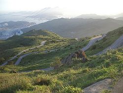
, who established the Country Parks and was himself an enthusiastic hiker. The trail passes through a variety of natural and beautiful scenery.
The New Territories
New Territories
New Territories is one of the three main regions of Hong Kong, alongside Hong Kong Island and the Kowloon Peninsula. It makes up 86.2% of Hong Kong's territory. Historically, it is the region described in The Convention for the Extension of Hong Kong Territory...
, through which the MacLehose Trail runs, covers the majority of the SAR's land area. Here is Hong Kong's most varied - and finest - countryside. The east coast, where the Trail begins, is deeply indented and wild. The central mountains, which the MacLehose Trail crosses, include many of Hong Kong's highest peaks. And the western part, where the Trail winds to its end, has impressive valley reservoirs
Reservoirs of Hong Kong
Reservoirs in Hong Kong are spread fairly evenly over the entire 1,104 km² of Hong Kong. There is plenty of space for small reservoirs in Hong Kong, as the hilly areas provide valleys suitable for water storage. However, the larger reservoirs, i.e. High Island Reservoir and Plover Cover Reservoir,...
.
Stages
The MacLehose Trail is divided into ten stages:| Stage | Route | Length (km) | Time (hr) | Difficulty |
|---|---|---|---|---|
| 1 | Pak Tam Chung Pak Tam Chung Pak Tam Chung is an area in the southern part of the Sai Kung Peninsula in the New Territories of Hong Kong. It is administratively under the Sai Kung District.... → Long Ke |
10.6 | 3.0 | |
| 2 | Long Ke → Pak Tam Au | 13.5 | 5.0 | |
| 3 | Pak Tam Au → Kei Ling Ha Kei Ling Ha Kei Ling Ha is an area on the Sai Kung Peninsula, in eastern New Territories of Hong Kong.Part of the Tai Po District. Kei Ling Ha is located at the coastal area near Sai Sha Road, at the junction of Ma On Shan Country Park and Sai Kung West Country Park.Kei Ling Ha is located in the innermost... |
10.2 | 4.0 | |
| 4 | Kei Ling Ha Kei Ling Ha Kei Ling Ha is an area on the Sai Kung Peninsula, in eastern New Territories of Hong Kong.Part of the Tai Po District. Kei Ling Ha is located at the coastal area near Sai Sha Road, at the junction of Ma On Shan Country Park and Sai Kung West Country Park.Kei Ling Ha is located in the innermost... → Tai Lo Shan |
12.7 | 5.0 | |
| 5 | Tai Lo Shan → Tai Po Road Tai Po Road Tai Po Road is the second longest road in Hong Kong . It spans from Sham Shui Po in Kowloon to Tai Po in the New Territories of Hong Kong. Initially, the road was named Frontier Road.... |
10.6 | 3.0 | |
| 6 | Tai Po Road Tai Po Road Tai Po Road is the second longest road in Hong Kong . It spans from Sham Shui Po in Kowloon to Tai Po in the New Territories of Hong Kong. Initially, the road was named Frontier Road.... → Shing Mun Shing Mun Shing Mun is an area between Tsuen Wan and Sha Tin in the New Territories of Hong Kong. It is formerly, as suggested by its Chinese characters, a gate between the two areas separated by a range of hills. The Shing Mun Valley carries water to Shing Mun River. Before the construction of Shing Mun... |
4.6 | 1.5 | |
| 7 | Shing Mun Shing Mun Shing Mun is an area between Tsuen Wan and Sha Tin in the New Territories of Hong Kong. It is formerly, as suggested by its Chinese characters, a gate between the two areas separated by a range of hills. The Shing Mun Valley carries water to Shing Mun River. Before the construction of Shing Mun... → Lead Mine Pass Lead Mine Pass Lead Mine Pass is a mountain pass in the New Territories, Hong Kong. It is near Grassy Hill and two walking trails, MacLehose Trail and Wilson Trail intersect at the pass. The pass lies to the north of Shing Mun Reservoir.-External links:*... |
6.2 | 2.5 | |
| 8 | Lead Mine Pass Lead Mine Pass Lead Mine Pass is a mountain pass in the New Territories, Hong Kong. It is near Grassy Hill and two walking trails, MacLehose Trail and Wilson Trail intersect at the pass. The pass lies to the north of Shing Mun Reservoir.-External links:*... → Route Twisk Route Twisk Route Twisk is a steep and tortuous dual-lane road in Hong Kong, linking Tsuen Wan and Pat Heung via Shek Kong. It joins Kam Tin Road and Lam Kam Road north in Kam Tin, and ends in the Tsuen Kam Interchange of Cheung Pei Shan Road, Texaco Road North, Wai Tsuen Road and Tai Ho Road North south in... |
9.7 | 4.0 | |
| 9 | Route Twisk Route Twisk Route Twisk is a steep and tortuous dual-lane road in Hong Kong, linking Tsuen Wan and Pat Heung via Shek Kong. It joins Kam Tin Road and Lam Kam Road north in Kam Tin, and ends in the Tsuen Kam Interchange of Cheung Pei Shan Road, Texaco Road North, Wai Tsuen Road and Tai Ho Road North south in... → Tin Fu Tsai |
6.3 | 2.5 | |
| 10 | Tin Fu Tsai → Tuen Mun Tuen Mun Tuen Mun is a town near the mouth of Tuen Mun River and Castle Peak Bay in the New Territories, Hong Kong. It was one of the earliest settlements in Hong Kong which can be dated back to the Neolithic period. In the more recent past, it was home to many Tanka fishermen who gathered at the Castle... |
15.6 | 5.0 |
Easy Walk
Fairly Difficult
Very Difficult
Trailwalker
OxfamOxfam
Oxfam is an international confederation of 15 organizations working in 98 countries worldwide to find lasting solutions to poverty and related injustice around the world. In all Oxfam’s actions, the ultimate goal is to enable people to exercise their rights and manage their own lives...
Trailwalker
Trailwalker
Trailwalker or Oxfam Trailwalker and the related Trailtrekker are endurance walking events run across the world by Oxfam, in which teams of 4 competitors must complete a course of in a set time limit - typically between 24 and 48 hours...
, a major fundraising event in Hong Kong, takes place annually in November on the MacLehose Trail and additional route. The Start Point is at Pak Tam Chung in Sai Kung and the Finish Point is at Po Leung Kuk Jockey Club Tai Tong Holiday Camp in Yuen Long.
See also
- List of long-distance footpaths in Hong Kong