
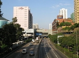
Tai Po Road
Encyclopedia

Hong Kong
Hong Kong is one of two Special Administrative Regions of the People's Republic of China , the other being Macau. A city-state situated on China's south coast and enclosed by the Pearl River Delta and South China Sea, it is renowned for its expansive skyline and deep natural harbour...
(after Castle Peak Road
Castle Peak Road
Castle Peak Road is the longest road in Hong Kong. It runs from Tai Po Road in Sham Shui Po, Kowloon to the very north of the New Territories, serving south, west and north New Territories, being one of the most distant roads in early Hong Kong.-Name:...
). It spans from Sham Shui Po
Sham Shui Po
Sham Shui Po, or Shamshuipo, is an area of Sham Shui Po District, Hong Kong, situated in the northwestern part of the Kowloon Peninsula, north of Tai Kok Tsui, east of Cheung Sha Wan and south of Shek Kip Mei. Sham Shui Po is known for its street market for electronic devices.-History:Sham Shui Po...
in Kowloon
Kowloon
Kowloon is an urban area in Hong Kong comprising the Kowloon Peninsula and New Kowloon. It is bordered by the Lei Yue Mun strait in the east, Mei Foo Sun Chuen and Stonecutter's Island in the west, Tate's Cairn and Lion Rock in the north, and Victoria Harbour in the south. It had a population of...
to Tai Po
Tai Po
Tai Po is an area in the New Territories of Hong Kong. It refers to the vicinity of the traditional market towns in the area presently known as Tai Po Old Market or Tai Po Kau Hui and the Tai Wo Town on the other side of the Lam Tsuen River, near the old Tai Po Market Station of the...
in the New Territories
New Territories
New Territories is one of the three main regions of Hong Kong, alongside Hong Kong Island and the Kowloon Peninsula. It makes up 86.2% of Hong Kong's territory. Historically, it is the region described in The Convention for the Extension of Hong Kong Territory...
of Hong Kong
Hong Kong
Hong Kong is one of two Special Administrative Regions of the People's Republic of China , the other being Macau. A city-state situated on China's south coast and enclosed by the Pearl River Delta and South China Sea, it is renowned for its expansive skyline and deep natural harbour...
. Initially, the road was named Frontier Road.
Before the construction of the Fanling Highway
Fanling Highway
Fanling Highway is a part of Route 9 in Hong Kong. It connects the new town of Tai Po and San Tin Highway, passing through Sheung Shui and Fanling on its way. The three lane expressway was constructed between 1983 and 1987....
, the road connected Fanling
Fanling
Fanling , also known as Fan Ling and Fan Leng, is an area in the New Territories of Hong Kong. Administratively, it is part of the North District...
and Sheung Shui
Sheung Shui
Sheung Shui is an area in New Territories, Hong Kong. Sheung Shui Town, a part of this area, is part of the Fanling-Sheung Shui New Town in the North District of Hong Kong. Fanling Town is to its southeast.-History:...
. It is one of the earliest major roads in the New Territories.
The road begins at Nathan Road near Sham Shui Po, runs through the valley between Golden Hill and Beacon Hill, and connects to Sha Tin
Sha Tin
Sha Tin, also spelled Shatin, is an area around the Shing Mun River in the New Territories of Hong Kong. Administratively, it is part of the Sha Tin District.-Geography:...
. It then continues northward along Sha Tin Hoi and Tai Po Hoi.
See also
- List of streets and roads in Hong Kong
- North Kowloon MagistracyNorth Kowloon MagistracyThe North Kowloon Magistracy is a historic building and former Magistrate's Court located at No. 292, Tai Po Road, Shek Kip Mei, Kowloon, Hong Kong....
, located at No. 292
External links
- Google Maps of Tai Po Road:
- http://maps.google.com/maps?f=d&hl=en&geocode=&saddr=%E5%A4%A7%E5%9F%94%E9%81%93+%4022.327200,+114.167080&daddr=%E5%A4%A7%E5%9F%94%E5%85%AC%E8%B7%AF%E3%80%80%EF%BC%8D%E3%80%80%E7%90%B5%E7%90%B6%E5%B1%B1%E6%AE%B5%2F%E5%A4%A7%E5%9F%94%E5%85%AC%E8%B7%AF-%E7%90%B5%E7%90%B6%E5%B1%B1%E6%AE%B5+%4022.348360,+114.152110+to:22.40845,114.210337+to:%E5%A4%A7%E5%9F%94%E5%85%AC%E8%B7%AF%E3%80%80%EF%BC%8D%E3%80%80%E5%85%83%E6%B4%B2%E4%BB%94%E6%AE%B5%2F%E5%A4%A7%E5%9F%94%E5%85%AC%E8%B7%AF-%E5%85%83%E6%B4%B2%E4%BB%94%E6%AE%B5+%4022.446650,+114.172000&mrcr=1,2&mrsp=2&sz=17&mra=dpe&sll=22.407111,114.209726&sspn=0.004067,0.007296&ie=UTF8&ll=22.386925,114.180725&spn=0.260307,0.466919&z=11&om=1All sections except Tai Wo (大窩段)]
- http://maps.google.com/maps?f=d&hl=en&geocode=&saddr=%E5%A4%A7%E5%9F%94%E5%85%AC%E8%B7%AF%E3%80%80%EF%BC%8D%E3%80%80%E5%A4%A7%E7%AA%A9%E6%AE%B5%2F%E5%A4%A7%E5%9F%94%E5%85%AC%E8%B7%AF-%E5%A4%A7%E7%AA%A9%E6%AE%B5+%4022.452300,+114.158730&daddr=22.460801,114.146866&mrcr=0&mrsp=1&sz=18&mra=dme&sll=22.460979,114.14752&sspn=0.002033,0.003648&ie=UTF8&ll=22.456885,114.15279&spn=0.016261,0.029182&z=15&om=1Tai Wo section (大窩段)]