
.gif)
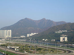
Ma On Shan (peak)
Encyclopedia
Tolo Harbour
Tolo Harbour , or Tai Po Hoi is a sheltered harbour in northeast New Territories of Hong Kong.-Geography:Tide Cove aka...
in the New Territories
New Territories
New Territories is one of the three main regions of Hong Kong, alongside Hong Kong Island and the Kowloon Peninsula. It makes up 86.2% of Hong Kong's territory. Historically, it is the region described in The Convention for the Extension of Hong Kong Territory...
of Hong Kong
Hong Kong
Hong Kong is one of two Special Administrative Regions of the People's Republic of China , the other being Macau. A city-state situated on China's south coast and enclosed by the Pearl River Delta and South China Sea, it is renowned for its expansive skyline and deep natural harbour...
. With a peak of 702 metres (2,303 ft), it stands among the ten highest mountains in Hong Kong. The mountain borders Sha Tin
Sha Tin District
Sha Tin District is one of the 18 districts of Hong Kong. One of the 9 districts located in the New Territories, it covers the areas of Sha Tin, Tai Wai, Ma On Shan, Fo Tan, Siu Lek Yuen and Ma Liu Shui . The district has the highest population...
and Tai Po
Tai Po District
Tai Po District is one of the 18 districts of Hong Kong. It covers the areas of Tai Po, Tai Po Kau, Ting Kok, Plover Cove and the northern part of Sai Kung Peninsula on both shores of Tolo Channel. It is located in the New Territories...
districts
Districts of Hong Kong
The Districts of Hong Kong are the 18 political areas by which Hong Kong is geographically divided. Each district has a district council, which was formerly known as a district board. The districts were established in the early 1980s, when Hong Kong was under British rule...
.
Iron ore was mined here in the past. An extensive network of tunnels is buried under the hill. The iron mine was abandoned after losing advantages over other less expensive sources.
Beneath the west face of the hill along Tolo Harbour
Tolo Harbour
Tolo Harbour , or Tai Po Hoi is a sheltered harbour in northeast New Territories of Hong Kong.-Geography:Tide Cove aka...
, a new town extension, Ma On Shan, of Sha Tin New Town
Sha Tin New Town
Sha Tin New Town is one of the new towns in Hong Kong. It is within the Sha Tin District, which covers the areas of Sha Tin, Tai Wai, Fo Tan, Tai Shui Hang, Ma On Shan, etc. With development started in the 1970s, it covers an area of 35.87 square kilometres . It presently has a population over...
is named after the hill. It ends north in Wu Kai Sha
Wu Kai Sha
Wu Kai Sha , formerly known as Wu Kwai Sha or U Kwai Sha , is a place at the shore of Tolo Harbour, northwest of Ma On Shan in the New Territories, Hong Kong. It is famous for a campsite, Wu Kai Sha Youth Village of YMCA. Originally there were only a few villages like Wu Kwai Sha Village. It is...
.
East of the hill is the group of villages named Shap Sze Heung
Shap Sze Heung
Shap Sze Heung is an area in Hong Kong, located in the northern part of Sai Kung Peninsula. Despite its proximity to the neighbouring areas administered by Sha Tin and Sai Kung districts, it is actually administered by Tai Po District.-Villages:...
and the harbour of Three Fathoms Cove
Three Fathoms Cove
Three Fathoms Cove or Kei Ling Ha Hoi is a cove in Tai Po District, Hong Kong. It is surrounded by Shap Sze Heung , Kei Ling Ha , Yung Shue O , Wong Tei Tung and Sham Chung . Most of its east shore constitutes part of the Sai Kung West Country Park.The cove's north is connected to Tolo Harbour...
.
See also
- List of mountains, peaks and hills in Hong Kong
- Ma On Shan (town) - new town development to the northern side of the peak