

Sha Tin New Town
Encyclopedia
New towns of Hong Kong
The area of Hong Kong is very mountainous and many places in the New Territories have limited access to roads. Hong Kong started developing new towns in the 1950s, to accommodate booming populations. In the early days the term "satellite towns" was used. The very first new towns included Tsuen Wan...
s in Hong Kong
Hong Kong
Hong Kong is one of two Special Administrative Regions of the People's Republic of China , the other being Macau. A city-state situated on China's south coast and enclosed by the Pearl River Delta and South China Sea, it is renowned for its expansive skyline and deep natural harbour...
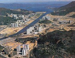
. It is within the Sha Tin District
Sha Tin District
Sha Tin District is one of the 18 districts of Hong Kong. One of the 9 districts located in the New Territories, it covers the areas of Sha Tin, Tai Wai, Ma On Shan, Fo Tan, Siu Lek Yuen and Ma Liu Shui . The district has the highest population...
, which covers the areas of Sha Tin
Sha Tin
Sha Tin, also spelled Shatin, is an area around the Shing Mun River in the New Territories of Hong Kong. Administratively, it is part of the Sha Tin District.-Geography:...
, Tai Wai
Tai Wai
Tai Wai is an area in the New Territories of Hong Kong, located between Sha Tin New Town and the Lion Rock. It is the largest part of the Sha Tin District....
, Fo Tan
Fo Tan
Fo Tan is a suburb of Sha Tin District, Hong Kong. It was developed as a light industrial area, but this activity has declined markedly in recent years. There are residential areas to the east, alongside the MTR line, and in the foothills to the west....
, Tai Shui Hang, Ma On Shan, etc. With development started in the 1970s, it covers an area of 35.87 square kilometres (total development area is about 20 km²). It presently has a population over 630,000. Its planned capacity when fully developed will be 735,000. Currently, in the town center houses a mall, creatively named, Sha Tin New Town Plaza. In the latest official reports, Ma On Shan New Town is distinct from Sha Tin New Town.