
.gif)
M-209 (Michigan highway)
Encyclopedia
M-209 was a state trunkline route
in the lower peninsula
of the US state of Michigan
. It was located in Leelanau County
in the Sleeping Bear Dunes National Lakeshore
. Until it was decommissioned
, it was Michigan's shortest state highway. M-209 started at M-109
and went 0.543 mile (0.87387162 km) or just 956 yards (874.2 m) to Glen Haven
. In 1996, M-209's designation was "abandoned", and the road was turned over to the jurisdiction of the Leelanau County Road Commission.
 M-209 was the short connector route from M-109 to the Glen Haven unit of the Sleeping Bear Dunes National Lakeshore west of Glen Arbor. The southern terminus of the highway was at the intersection with M-109 south of Glen Haven, a restored logging village on the shore of Lake Michigan
on the Leelanau Peninsula
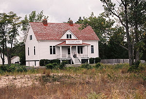
. The roadway ran north from this intersection where M-109 made a 90–degree corner through the south and east legs of a four-way intersection with M-209 and Dune Valley Road. M-209 ran past such attractions as the restored General Store and Blacksmith Shop. Also located in Glen Haven is the former Glen Haven Canning Co. building. This building was first used as a warehouse and later as a cannery for cherries in the 1920s. It has since been restored as the Cannery Boathouse housing historic wooden boats used in the Manitou Passage between Glen Haven, Glen Arbor and the Manitou Islands. The northern terminus of M-209 was located in front of the former U.S. Coast Guard Life Saving Station, now restored as a maritime museum. The museum is located at the intersection of Glen Haven Road and Sleeping Bear Dunes Road. At the time of decommissioning, M-209 was a two-lane, paved road.
Sleeping Bear Dunes National Lakeshore
is a United States National Lakeshore
located on the "little finger" of the lower peninsula of Michigan in Leelanau and Benzie
counties. The park covers a 35 miles (56 km) stretch of Lake Michigan's eastern coastline, as well as North
and South Manitou Island
s. The park was authorized on October 21, 1970.
control on June 5, 1996. It is now known only as Glen Haven Road. Since the transfer, M-212
in Cheboygan County
is now the shortest highway in the state.
Michigan Highway System
The Michigan State Trunkline Highway System is made up of all the highways designated as Interstates, U.S. Highways and State Highways in the US state of Michigan. The system is maintained by the Michigan Department of Transportation and comprises of trunklines in all 83 counties of Michigan on...
in the lower peninsula
Lower Peninsula of Michigan
The Lower Peninsula of Michigan is the southern of the two major landmasses of the U.S. state of Michigan. It is surrounded by water on all sides except its southern border, which it shares with Ohio and Indiana. Geographically, the Lower Peninsula has a recognizable shape that many people...
of the US state of Michigan
Michigan
Michigan is a U.S. state located in the Great Lakes Region of the United States of America. The name Michigan is the French form of the Ojibwa word mishigamaa, meaning "large water" or "large lake"....
. It was located in Leelanau County
Leelanau County, Michigan
-History:The county's name is said to be a Native American word meaning "delight of life", but it is a neologism made up by Indian agent and ethnographer Henry Schoolcraft, who sometimes gave the name "Leelinau" to Native American women in his tales. He created many faux Indian place names in...
in the Sleeping Bear Dunes National Lakeshore
Sleeping Bear Dunes National Lakeshore
Sleeping Bear Dunes National Lakeshore is a United States National Lakeshore located along the northwest coast of the Lower Peninsula of Michigan in Leelanau County and Benzie County....
. Until it was decommissioned
Decommissioned highway
A decommissioned highway is a highway that has been removed from service, shut down or has had its authorization as a federal or state highway removed. Decommissioning can include the complete or partial demolition or abandonment of an old highway structure because the old roadway has lost its...
, it was Michigan's shortest state highway. M-209 started at M-109
M-109 (Michigan highway)
M-109 is the designation of a state trunkline highway in the Lower Peninsula of the US state of Michigan that runs between Empire and Glen Arbor...
and went 0.543 mile (0.87387162 km) or just 956 yards (874.2 m) to Glen Haven
Glen Haven, Michigan
Glenn Haven is a restored logging village on the shore of Lake Michigan on the Leelanau Peninsula within the Sleeping Bear Dunes National Lakeshore. Attractions include the restored General Store and Blacksmith Shop. The unincorporated community is located in Glen Arbor Township.Also located in...
. In 1996, M-209's designation was "abandoned", and the road was turned over to the jurisdiction of the Leelanau County Road Commission.
Route description
Lake Michigan
Lake Michigan is one of the five Great Lakes of North America and the only one located entirely within the United States. It is the second largest of the Great Lakes by volume and the third largest by surface area, after Lake Superior and Lake Huron...
on the Leelanau Peninsula
Leelanau Peninsula
The Leelanau Peninsula is a peninsula of the U.S. state of Michigan that extends about from the Lower Peninsula of Michigan into Lake Michigan. Leelanau County encompasses the entire peninsula. It is often referred to as the "little finger" of the mitten-shaped lower peninsula.Sleeping Bear Dunes...
. The roadway ran north from this intersection where M-109 made a 90–degree corner through the south and east legs of a four-way intersection with M-209 and Dune Valley Road. M-209 ran past such attractions as the restored General Store and Blacksmith Shop. Also located in Glen Haven is the former Glen Haven Canning Co. building. This building was first used as a warehouse and later as a cannery for cherries in the 1920s. It has since been restored as the Cannery Boathouse housing historic wooden boats used in the Manitou Passage between Glen Haven, Glen Arbor and the Manitou Islands. The northern terminus of M-209 was located in front of the former U.S. Coast Guard Life Saving Station, now restored as a maritime museum. The museum is located at the intersection of Glen Haven Road and Sleeping Bear Dunes Road. At the time of decommissioning, M-209 was a two-lane, paved road.
Sleeping Bear Dunes National Lakeshore
Sleeping Bear Dunes National Lakeshore
Sleeping Bear Dunes National Lakeshore is a United States National Lakeshore located along the northwest coast of the Lower Peninsula of Michigan in Leelanau County and Benzie County....
is a United States National Lakeshore
United States National Lakeshore
The United States has ten protected areas known as national seashores and four known as national lakeshores, which are operated by the National Park Service, an agency of the Department of the Interior. National seashores and lakeshores must be established by an act of the United States Congress...
located on the "little finger" of the lower peninsula of Michigan in Leelanau and Benzie
Benzie County, Michigan
-Demographics:As of the 2000 census, there were 15,998 people, 6,500 households, and 4,595 families residing in the county. The population density was 50 people per square mile . There were 10,312 housing units at an average density of 32 per square mile...
counties. The park covers a 35 miles (56 km) stretch of Lake Michigan's eastern coastline, as well as North
North Manitou Island
North Manitou Island is located in Lake Michigan, approximately west-northwest of Leland, Michigan. It is nearly eight miles long and over four miles wide, with of shoreline. It has a land area of 57.876 km² and has no population...
and South Manitou Island
South Manitou Island
South Manitou Island is located in Lake Michigan, approximately west of Leland, Michigan. It is part of Leelanau County and the Sleeping Bear Dunes National Lakeshore. The uninhabited island is in land area and can be accessed by a ferry service from Leland...
s. The park was authorized on October 21, 1970.
History
From its inception in the 1920s, M-209 was Michigan's shortest highway. It connected the small community of Glen Haven to M-109 just south of the community. Glen Haven was founded as a settlement called Sleeping Bearville with a sawmill and an inn in 1857. By 1881, there were 11 buildings in the community. The lifesaving station was built in 1901 and moved to its present location in 1931 before closing in 1941. M-209 was first assumed as a state trunkline in the 1920s. It would later serve the national lakeshore when the park was created on October 21, 1970. The Park Service purchased all of the village by the mid-1970s. The highway was turned over to Leelanau CountyLeelanau County, Michigan
-History:The county's name is said to be a Native American word meaning "delight of life", but it is a neologism made up by Indian agent and ethnographer Henry Schoolcraft, who sometimes gave the name "Leelinau" to Native American women in his tales. He created many faux Indian place names in...
control on June 5, 1996. It is now known only as Glen Haven Road. Since the transfer, M-212
M-212 (Michigan highway)
M-212 is a state trunkline highway in the US state of Michigan. M-212 was designated in order to provide access from M-33 to both the small community of Aloha on the eastern shore of Mullett Lake, as well as to Aloha State Park, where the highway ends. M-212 is the shortest state highway in...
in Cheboygan County
Cheboygan County, Michigan
-Commercial Airline:There are no commercial airline airports in Cheboygan County but the nearest ones are Alpena County Regional Airport, Chippewa County International Airport , and Cherry Capital Airport...
is now the shortest highway in the state.