

United States National Lakeshore
Encyclopedia
The United States has ten protected area
s known as national seashores and four known as national lakeshores, which are operated by the National Park Service
, an agency of the Department of the Interior
. National seashores and lakeshores must be established by an act of the United States Congress
. National seashores and lakeshores are coastal areas federal
ly designated as being of natural and recreational significance as a preserved area. The first national seashore, Cape Hatteras
, was established in 1953, and Indiana Dune National Lakeshore was established in 1966. The newest national lakeshore is seashore is Canaveral
, established in 1975. All of the national lakeshores are on lakes Michigan
and Superior
, and nine of the ten national seashores are on the Atlantic Ocean
, including two on the Gulf of Mexico
.
National seashores are located in ten states and national lakeshores are in four other states. Florida
, North Carolina
, and Michigan
each have two. The largest national seashore or lakeshore is Gulf Islands
, at over 137000 acres (554.4 km²); the smallest is Indiana Dunes
, at 15000 acres (60.7 km²). The total areas protected by national seashores and lakeshores are approximately 595000 acres (2,407.9 km²) and 229000 acres (926.7 km²), respectively.
Protected area
Protected areas are locations which receive protection because of their recognised natural, ecological and/or cultural values. There are several kinds of protected areas, which vary by level of protection depending on the enabling laws of each country or the regulations of the international...
s known as national seashores and four known as national lakeshores, which are operated by the National Park Service
National Park Service
The National Park Service is the U.S. federal agency that manages all national parks, many national monuments, and other conservation and historical properties with various title designations...
, an agency of the Department of the Interior
United States Department of the Interior
The United States Department of the Interior is the United States federal executive department of the U.S. government responsible for the management and conservation of most federal land and natural resources, and the administration of programs relating to Native Americans, Alaska Natives, Native...
. National seashores and lakeshores must be established by an act of the United States Congress
United States Congress
The United States Congress is the bicameral legislature of the federal government of the United States, consisting of the Senate and the House of Representatives. The Congress meets in the United States Capitol in Washington, D.C....
. National seashores and lakeshores are coastal areas federal
Federal government of the United States
The federal government of the United States is the national government of the constitutional republic of fifty states that is the United States of America. The federal government comprises three distinct branches of government: a legislative, an executive and a judiciary. These branches and...
ly designated as being of natural and recreational significance as a preserved area. The first national seashore, Cape Hatteras
Cape Hatteras National Seashore
Cape Hatteras National Seashore preserves the portion of the Outer Banks of North Carolina from Bodie Island to Ocracoke Island, stretching over . Included within this section of barrier islands along N.C...
, was established in 1953, and Indiana Dune National Lakeshore was established in 1966. The newest national lakeshore is seashore is Canaveral
Canaveral National Seashore
The Canaveral National Seashore is a National Seashore located between New Smyrna Beach and Titusville, Florida, in Volusia County and Brevard County, United States. The park, located on a barrier island, is home to more than 1,000 plant species and 310 bird species. CANA occupies 58,000 acres ...
, established in 1975. All of the national lakeshores are on lakes Michigan
Lake Michigan
Lake Michigan is one of the five Great Lakes of North America and the only one located entirely within the United States. It is the second largest of the Great Lakes by volume and the third largest by surface area, after Lake Superior and Lake Huron...
and Superior
Lake Superior
Lake Superior is the largest of the five traditionally-demarcated Great Lakes of North America. It is bounded to the north by the Canadian province of Ontario and the U.S. state of Minnesota, and to the south by the U.S. states of Wisconsin and Michigan. It is the largest freshwater lake in the...
, and nine of the ten national seashores are on the Atlantic Ocean
Atlantic Ocean
The Atlantic Ocean is the second-largest of the world's oceanic divisions. With a total area of about , it covers approximately 20% of the Earth's surface and about 26% of its water surface area...
, including two on the Gulf of Mexico
Gulf of Mexico
The Gulf of Mexico is a partially landlocked ocean basin largely surrounded by the North American continent and the island of Cuba. It is bounded on the northeast, north and northwest by the Gulf Coast of the United States, on the southwest and south by Mexico, and on the southeast by Cuba. In...
.
National seashores are located in ten states and national lakeshores are in four other states. Florida
Florida
Florida is a state in the southeastern United States, located on the nation's Atlantic and Gulf coasts. It is bordered to the west by the Gulf of Mexico, to the north by Alabama and Georgia and to the east by the Atlantic Ocean. With a population of 18,801,310 as measured by the 2010 census, it...
, North Carolina
North Carolina
North Carolina is a state located in the southeastern United States. The state borders South Carolina and Georgia to the south, Tennessee to the west and Virginia to the north. North Carolina contains 100 counties. Its capital is Raleigh, and its largest city is Charlotte...
, and Michigan
Michigan
Michigan is a U.S. state located in the Great Lakes Region of the United States of America. The name Michigan is the French form of the Ojibwa word mishigamaa, meaning "large water" or "large lake"....
each have two. The largest national seashore or lakeshore is Gulf Islands
Gulf Islands National Seashore
Gulf Islands National Seashore offers recreation opportunities and preserves natural and historic resources along the Gulf of Mexico barrier islands of Florida and Mississippi. The protected regions include mainland areas and parts of 7 islands...
, at over 137000 acres (554.4 km²); the smallest is Indiana Dunes
Indiana Dunes National Lakeshore
Indiana Dunes National Lakeshore is a U.S. National Lakeshore located in northwest Indiana and managed by the National Park Service. It was authorized by Congress in 1966. The national lakeshore runs for nearly along the southern shore of Lake Michigan, from Gary, Indiana, on the west to Michigan...
, at 15000 acres (60.7 km²). The total areas protected by national seashores and lakeshores are approximately 595000 acres (2,407.9 km²) and 229000 acres (926.7 km²), respectively.
National Seashores
| Name | Photo | Location | Date Formed | Area | Description |
|---|---|---|---|---|---|
| Assateague Island Assateague Island National Seashore Assateague Island National Seashore is a unit of the National Park Service occupying much of Assateague Island along the Atlantic coast of Maryland and Virginia. It is a barrier island shaped by stormy seas and gentle winds. It lies adjacent to Assateague State Park and Chincoteague National... |
 |
Maryland Maryland Maryland is a U.S. state located in the Mid Atlantic region of the United States, bordering Virginia, West Virginia, and the District of Columbia to its south and west; Pennsylvania to its north; and Delaware to its east... , Virginia Virginia The Commonwealth of Virginia , is a U.S. state on the Atlantic Coast of the Southern United States. Virginia is nicknamed the "Old Dominion" and sometimes the "Mother of Presidents" after the eight U.S. presidents born there... 38.08°N 75.21°W |
39726.75 acres (160.8 km²) | As a barrier island Barrier island Barrier islands, a coastal landform and a type of barrier system, are relatively narrow strips of sand that parallel the mainland coast. They usually occur in chains, consisting of anything from a few islands to more than a dozen... , Assateague Island Assateague Island Assateague Island is a long barrier island located off the eastern coast of Maryland and Virginia. It is best known for its herds of feral horses, pristine beaches, and the Assateague Lighthouse. The island also contains numerous marshes, bays and coves, including Toms Cove... is continually shaped by wind and waves. It is known for its feral horses and is also home to deer, crabs, fox, and migrating snow geese. Main vegetation includes American beach grass Ammophila breviligulata Ammophila breviligulata is a species of grass that is native to eastern North America, where it grows on sand dunes along the Atlantic Ocean and Great Lakes coasts... , saltmarsh cordgrass Spartina alterniflora Spartina alterniflora is a perennial deciduous grass which is found in intertidal wetlands, especially estuarine salt marshes. It grows 1-1.5 m tall, and has smooth, hollow stems which bear leaves up to 20-60 cm long and 1.5 cm wide at their base, which are sharply tapered and bend down... and sea rocket. |
|
| Canaveral Canaveral National Seashore The Canaveral National Seashore is a National Seashore located between New Smyrna Beach and Titusville, Florida, in Volusia County and Brevard County, United States. The park, located on a barrier island, is home to more than 1,000 plant species and 310 bird species. CANA occupies 58,000 acres ... |
Florida Florida Florida is a state in the southeastern United States, located on the nation's Atlantic and Gulf coasts. It is bordered to the west by the Gulf of Mexico, to the north by Alabama and Georgia and to the east by the Atlantic Ocean. With a population of 18,801,310 as measured by the 2010 census, it... 28.77°N 80.78°W |
57661.69 acres (233.3 km²) | Adjacent to the Kennedy Space Center Kennedy Space Center The John F. Kennedy Space Center is the NASA installation that has been the launch site for every United States human space flight since 1968. Although such flights are currently on hiatus, KSC continues to manage and operate unmanned rocket launch facilities for America's civilian space program... , this barrier island has a variety of recreational activities including hiking, boating, and fishing. The Seminole Rest features an ancient Native American mound, and Eldora Statehouse shows historic life on the lagoon. Florida's longest undeloped Atlantic beach surrounds Mosquito Lagoon, which is home to dolphins, manatees, and sea turtles, along with a variety of sea grasses. |
||
| Cape Cod Cape Cod National Seashore The Cape Cod National Seashore , created on August 7, 1961 by President John F. Kennedy, encompasses on Cape Cod, Massachusetts. It includes ponds, woods and beachfront of the Atlantic coastal pine barrens ecoregion... |
Massachusetts Massachusetts The Commonwealth of Massachusetts is a state in the New England region of the northeastern United States of America. It is bordered by Rhode Island and Connecticut to the south, New York to the west, and Vermont and New Hampshire to the north; at its east lies the Atlantic Ocean. As of the 2010... 41.95°N 70.00°W |
43608.48 acres (176.5 km²) | Beyond its nearly 40 miles of beaches, this historic area has Marconi Station Marconi Station The Marconi Wireless Corporation operated numerous pioneering radio stations in Canada, Ireland, Newfoundland, the United States, the United Kingdom and a number of other locations around the world.-Australia:... , the Three Sisters Lighthouses, and the former North Truro Air Force Station North Truro Air Force Station North Truro Air Force Station is a closed United States Air Force General Surveillance Radar station. It is located east of North Truro, Massachusetts.... . Cranberry bogs, marshes, and hiking trails provide a look into the flora and fauna of Cape Cod Cape Cod Cape Cod, often referred to locally as simply the Cape, is a cape in the easternmost portion of the state of Massachusetts, in the Northeastern United States... . |
||
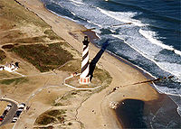
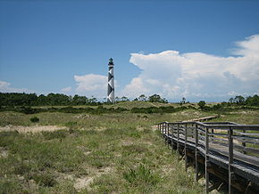
| Cape Hatteras Cape Hatteras National Seashore Cape Hatteras National Seashore preserves the portion of the Outer Banks of North Carolina from Bodie Island to Ocracoke Island, stretching over . Included within this section of barrier islands along N.C... |
 |
North Carolina North Carolina North Carolina is a state located in the southeastern United States. The state borders South Carolina and Georgia to the south, Tennessee to the west and Virginia to the north. North Carolina contains 100 counties. Its capital is Raleigh, and its largest city is Charlotte... 35.30°N 75.51°W |
30350.65 acres (122.8 km²) | Located in the Outer Banks Outer Banks The Outer Banks is a 200-mile long string of narrow barrier islands off the coast of North Carolina, beginning in the southeastern corner of Virginia Beach on the east coast of the United States.... , Cape Hatteras is known for its Bodie Island Bodie Island Light The current Bodie Island Lighthouse is the third that has stood in this vicinity of Bodie Island on the Outer Banks in North Carolina and was built in 1872. It stands tall and is located on the Roanoke Sound side of the first island that is part of the Cape Hatteras National Seashore. The... and Cape Hatteras Light Cape Hatteras Light Cape Hatteras Light is a lighthouse located on Hatteras Island in the Outer Banks of North Carolina near the community of Buxton, and is part of the Cape Hatteras National Seashore.... houses. Popular recreation activities include windsurfing, birdwatching, fishing, shell collecting, and kayaking. Constantly changing from ocean activity, this barrier island provides refuge for the endangered piping plover Piping Plover The Piping Plover is a small sand-colored, sparrow-sized shorebird that nests and feeds along coastal sand and gravel beaches in North America. The adult has yellow-orange legs, a black band across the forehead from eye to eye, and a black ring around the neck... , seabeach amaranth Amaranth Amaranthus, collectively known as amaranth, is a cosmopolitan genus of herbs. Approximately 60 species are recognized, with inflorescences and foliage ranging from purple and red to gold... , and sea turtles. |
|
| Cape Lookout Cape Lookout National Seashore Cape Lookout National Seashore preserves a 56-mile long section of the Southern Outer Banks, or Crystal Coast, of North Carolina, USA, running from Ocracoke Inlet on the northeast to Beaufort Inlet on the southeast. Three undeveloped barrier islands make up the seashore - North Core Banks, South... |
 |
North Carolina North Carolina North Carolina is a state located in the southeastern United States. The state borders South Carolina and Georgia to the south, Tennessee to the west and Virginia to the north. North Carolina contains 100 counties. Its capital is Raleigh, and its largest city is Charlotte... 34.61°N 76.54°W |
28243.36 acres (114.3 km²) | Cape Lookout National Seashore is made up of three islands of the Outer Banks Outer Banks The Outer Banks is a 200-mile long string of narrow barrier islands off the coast of North Carolina, beginning in the southeastern corner of Virginia Beach on the east coast of the United States.... . It is known for its wild horses and the Cape Lookout Lighthouse Cape Lookout Lighthouse The Cape Lookout Lighthouse is a 163-foot high lighthouse located on the Southern Outer Banks of North Carolina. It flashes every 15 seconds and is visible at least 12 miles out to sea and up to 19 miles. The Cape Lookout Light is one of the very few lighthouses that operate during the day. It... . Hiking, camping, fishing, and birdwatching are popular recreational activities. It is also home to two historic villages. |
|
| Cumberland Island Cumberland Island National Seashore Cumberland Island National Seashore preserves most of Cumberland Island in Camden County, Georgia, the largest of Georgia's Golden Isles. The seashore features beaches and dunes, marshes, and freshwater lakes... |
 |
Georgia Georgia (U.S. state) Georgia is a state located in the southeastern United States. It was established in 1732, the last of the original Thirteen Colonies. The state is named after King George II of Great Britain. Georgia was the fourth state to ratify the United States Constitution, on January 2, 1788... 30.83°N 81.45°W |
36415.13 acres (147.4 km²) | Cumberland Island Cumberland Island Cumberland Island is one of the Sea Islands. Cumberland is the largest in terms of continuously exposed land area of Georgia's barrier islands. It is located on the Atlantic Ocean off the coast of the U.S. state of Georgia and is part of Camden County... is the site of the Plum Orchard Plum Orchard Plum Orchard is an estate located in the middle of the western shore of Cumberland Island, Georgia. The estate and surrounding area are listed on the National Register of Historic Places.... estate, Thomas Carnegie's ruined Dungeness Dungeness (Cumberland Island, Georgia) Dungeness on Cumberland Island, Georgia, is a ruined mansion that is part of a historic district that was the home of several families significant in American history. James Oglethorpe first built on Cumberland Island in 1736, building a hunting lodge that he named Dungeness... mansion, and an African Baptist church. The museum on the mainland preserves Timucua Timucua The Timucua were a Native American people who lived in Northeast and North Central Florida and southeast Georgia. They were the largest indigenous group in that area and consisted of about 35 chiefdoms, many leading thousands of people. The various groups of Timucua spoke several dialects of the... Indian history, Nathaniel Green and Eli Whitney Eli Whitney Eli Whitney was an American inventor best known for inventing the cotton gin. This was one of the key inventions of the Industrial Revolution and shaped the economy of the Antebellum South... 's works, and War of 1812 War of 1812 The War of 1812 was a military conflict fought between the forces of the United States of America and those of the British Empire. The Americans declared war in 1812 for several reasons, including trade restrictions because of Britain's ongoing war with France, impressment of American merchant... battles. |
|
| Fire Island Fire Island National Seashore Fire Island National Seashore is a United States National Seashore that protects a section of Fire Island, an approximately long barrier island separated from Long Island by the Great South Bay.... |
New York New York New York is a state in the Northeastern region of the United States. It is the nation's third most populous state. New York is bordered by New Jersey and Pennsylvania to the south, and by Connecticut, Massachusetts and Vermont to the east... 40.70°N 72.98°W |
19579.47 acres (79.2 km²) | Fire Island, a barrier island south of Long Island Long Island Long Island is an island located in the southeast part of the U.S. state of New York, just east of Manhattan. Stretching northeast into the Atlantic Ocean, Long Island contains four counties, two of which are boroughs of New York City , and two of which are mainly suburban... , has the historic William Floyd House William Floyd House William Floyd House, also known as Nicholl Floyd House and Old Mastic House, was a home of William Floyd, a signer of the U.S. Declaration of Independence, in Mastic, New York. It was his home from 1734 until 1803. This home is distinct from Gen... and Fire Island Lighthouse Fire Island Lighthouse The Fire Island Light is a visible landmark on the Great South Bay, in southern Suffolk County, New York on the western end of Fire Island, a barrier island off the southern coast of Long Island... . The beaches and dunes are complemented by a sunken forest, wetlands, and seventeen communities. |
||
| Gulf Islands Gulf Islands National Seashore Gulf Islands National Seashore offers recreation opportunities and preserves natural and historic resources along the Gulf of Mexico barrier islands of Florida and Mississippi. The protected regions include mainland areas and parts of 7 islands... |
 |
Florida Florida Florida is a state in the southeastern United States, located on the nation's Atlantic and Gulf coasts. It is bordered to the west by the Gulf of Mexico, to the north by Alabama and Georgia and to the east by the Atlantic Ocean. With a population of 18,801,310 as measured by the 2010 census, it... , Mississippi Mississippi Mississippi is a U.S. state located in the Southern United States. Jackson is the state capital and largest city. The name of the state derives from the Mississippi River, which flows along its western boundary, whose name comes from the Ojibwe word misi-ziibi... 30.36°N 86.97°W |
137990.97 acres (558.4 km²) | Seven main islands have four historic forts built by the Spanish, British, and Americans that were used for defense in the Civil War. Apache Apache Apache is the collective term for several culturally related groups of Native Americans in the United States originally from the Southwest United States. These indigenous peoples of North America speak a Southern Athabaskan language, which is related linguistically to the languages of Athabaskan... Indians once lived here, including Geronimo Geronimo Geronimo was a prominent Native American leader of the Chiricahua Apache who fought against Mexico and the United States for their expansion into Apache tribal lands for several decades during the Apache Wars. Allegedly, "Geronimo" was the name given to him during a Mexican incident... . There are nature trails for wildlife viewing and long beaches for snorkeling, biking, and other activities. |
|
| Padre Island Padre Island National Seashore Padre Island National Seashore is a National Seashore located on Padre Island off the coast of South Texas. In contrast to South Padre Island , PINS is located on North Padre Island and consists of a long beach where nature is preserved... |
 |
Texas Texas Texas is the second largest U.S. state by both area and population, and the largest state by area in the contiguous United States.The name, based on the Caddo word "Tejas" meaning "friends" or "allies", was applied by the Spanish to the Caddo themselves and to the region of their settlement in... 27°N 97.38°W |
130434.27 acres (527.8 km²) | Padre Island Padre Island Padre Island is part of the U.S. state of Texas. The island is located on Texas' southern coast of the Gulf of Mexico and is famous for its white sandy beaches at the south end... , the world's longest undeveloped barrier island, is a nesting ground for the Kemp's ridley Kemp's Ridley Kemp's ridley sea turtle , or Atlantic ridley sea turtle is the rarest sea turtle and is critically endangered. It is one of two living species in the genus Lepidochelys Kemp's ridley sea turtle (Lepidochelys kempii), or Atlantic ridley sea turtle is the rarest sea turtle and is critically... sea turtle and a migratory site for Least Terns, Brown Pelican Brown Pelican The Brown Pelican is the smallest of the eight species of pelican, although it is a large bird in nearly every other regard. It is in length, weighs from and has a wingspan from .-Range and habits:... s, and Piping Plover Piping Plover The Piping Plover is a small sand-colored, sparrow-sized shorebird that nests and feeds along coastal sand and gravel beaches in North America. The adult has yellow-orange legs, a black band across the forehead from eye to eye, and a black ring around the neck... s. Malaquite Beach provides a variety of recreational activities, and Novillo Line Camp has the remains of a cattle ranch. The military used part of the island as a bombing range during WWII. |
|
| Point Reyes Point Reyes National Seashore Point Reyes National Seashore is a park preserve located on the Point Reyes Peninsula in Marin County, California, USA. As a national seashore, it is maintained by the US National Park Service as a nationally important nature preserve within which existing agricultural uses are allowed to continue... |
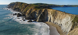 |
California California California is a state located on the West Coast of the United States. It is by far the most populous U.S. state, and the third-largest by land area... 38.00°N 123.00°W |
71067.78 acres (287.6 km²) | Historic locations on Point Reyes Peninsula include the Point Reyes Lighthouse and Lifeboat Station Point Reyes Lifeboat Station Point Reyes Lifeboat Station, also known as Point Reyes Lifeboat Rescue Station, was built in 1927 by the United States Lifesaving Service . It used rail launched 36 foot motorized lifeboats to aid ships foundering on Point Reyes. It was a replacement to another station that was built in 1888... and a recreated Coast Miwok Coast Miwok The Coast Miwok were the second largest group of Miwok Native American people. The Coast Miwok inhabited the general area of modern Marin County and southern Sonoma County in Northern California, from the Golden Gate north to Duncans Point and eastward to Sonoma Creek... village. Gray whale Gray Whale The gray whale, Eschrichtius robustus, is a baleen whale that migrates between feeding and breeding grounds yearly. It reaches a length of about , a weight of , and lives 50–70 years. The common name of the whale comes from the gray patches and white mottling on its dark skin. Gray whales were... s can be seen as they migrate near the seashore, and tule elk Tule Elk The tule elk is a subspecies of elk found only in California, ranging from the grasslands and marshlands of the Central Valley to the grassy hills on the coast. The subspecies name derives from the tule that it feeds off of, which grows in the marshlands... and elephant seal Elephant seal Elephant seals are large, oceangoing seals in the genus Mirounga. There are two species: the northern elephant seal and the southern elephant seal . Both were hunted to the brink of extinction by the end of the 19th century, but numbers have since recovered... s populate the wilderness area. |
National Lakeshores
| Name | Photo | Location | Date Formed | Area | Description |
|---|---|---|---|---|---|
| Apostle Islands Apostle Islands National Lakeshore The Apostle Islands National Lakeshore is a U.S. national lakeshore consisting of 21 islands and shoreline encompassing 69,372 acres on the northern tip of Wisconsin on the shore of Lake Superior.... |
Wisconsin Wisconsin Wisconsin is a U.S. state located in the north-central United States and is part of the Midwest. It is bordered by Minnesota to the west, Iowa to the southwest, Illinois to the south, Lake Michigan to the east, Michigan to the northeast, and Lake Superior to the north. Wisconsin's capital is... 46.97°N 90.66°W |
69371.89 acres (280.7 km²) | |||
| Indiana Dunes Indiana Dunes National Lakeshore Indiana Dunes National Lakeshore is a U.S. National Lakeshore located in northwest Indiana and managed by the National Park Service. It was authorized by Congress in 1966. The national lakeshore runs for nearly along the southern shore of Lake Michigan, from Gary, Indiana, on the west to Michigan... |
 |
Indiana Indiana Indiana is a US state, admitted to the United States as the 19th on December 11, 1816. It is located in the Midwestern United States and Great Lakes Region. With 6,483,802 residents, the state is ranked 15th in population and 16th in population density. Indiana is ranked 38th in land area and is... 41.65°N 87.12°W |
15067.38 acres (61 km²) | ||
| Pictured Rocks Pictured Rocks National Lakeshore Pictured Rocks National Lakeshore is a U.S. National Lakeshore on the shore of Lake Superior in the Upper Peninsula of Michigan, United States. It extends for 42 miles along the shore and covers... |
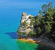 |
Michigan Michigan Michigan is a U.S. state located in the Great Lakes Region of the United States of America. The name Michigan is the French form of the Ojibwa word mishigamaa, meaning "large water" or "large lake".... 46.56°N 86.31°W |
73235.83 acres (296.4 km²) | ||
| Sleeping Bear Dunes Sleeping Bear Dunes National Lakeshore Sleeping Bear Dunes National Lakeshore is a United States National Lakeshore located along the northwest coast of the Lower Peninsula of Michigan in Leelanau County and Benzie County.... |
Michigan Michigan Michigan is a U.S. state located in the Great Lakes Region of the United States of America. The name Michigan is the French form of the Ojibwa word mishigamaa, meaning "large water" or "large lake".... 44.91°N 86.02°W |
71198.48 acres (288.1 km²) |
See also
- List of areas in the United States National Park System
- History of the National Park Service
- List of National Historic Landmarks of the United States
- List of National Monuments of the United States
External links
of the National Park ServiceNational Park Service
The National Park Service is the U.S. federal agency that manages all national parks, many national monuments, and other conservation and historical properties with various title designations...
- Find a Park by the NPS