
.gif)
Lost River (New Hampshire)
Encyclopedia
Stream
A stream is a body of water with a current, confined within a bed and stream banks. Depending on its locale or certain characteristics, a stream may be referred to as a branch, brook, beck, burn, creek, "crick", gill , kill, lick, rill, river, syke, bayou, rivulet, streamage, wash, run or...
located in the White Mountains
White Mountains (New Hampshire)
The White Mountains are a mountain range covering about a quarter of the state of New Hampshire and a small portion of western Maine in the United States. Part of the Appalachian Mountains, they are considered the most rugged mountains in New England...
of New Hampshire
New Hampshire
New Hampshire is a state in the New England region of the northeastern United States of America. The state was named after the southern English county of Hampshire. It is bordered by Massachusetts to the south, Vermont to the west, Maine and the Atlantic Ocean to the east, and the Canadian...
in the United States
United States
The United States of America is a federal constitutional republic comprising fifty states and a federal district...
. It is a tributary
Tributary
A tributary or affluent is a stream or river that flows into a main stem river or a lake. A tributary does not flow directly into a sea or ocean...
of the Pemigewasset River
Pemigewasset River
The Pemigewasset River , known locally as "The Pemi", is a river in the state of New Hampshire, the United States. It is in length and drains approximately...
, part of the Merrimack River
Merrimack River
The Merrimack River is a river in the northeastern United States. It rises at the confluence of the Pemigewasset and Winnipesaukee rivers in Franklin, New Hampshire, flows southward into Massachusetts, and then flows northeast until it empties into the Atlantic Ocean at Newburyport...
watershed
Drainage basin
A drainage basin is an extent or an area of land where surface water from rain and melting snow or ice converges to a single point, usually the exit of the basin, where the waters join another waterbody, such as a river, lake, reservoir, estuary, wetland, sea, or ocean...
.
The Lost River begins in Kinsman Notch
Kinsman Notch
Kinsman Notch is a mountain pass located in the White Mountains of New Hampshire, United States. It is the westernmost of the major notches through the White Mountains...
, one of the major passes
Mountain pass
A mountain pass is a route through a mountain range or over a ridge. If following the lowest possible route, a pass is locally the highest point on that route...
through the White Mountains. As it flows through the notch, it passes through Lost River Gorge
Lost River Reservation
The Lost River Reservation is a series of caves in the White Mountains in Woodstock, New Hampshire, United States. Located west of the village of North Woodstock on New Hampshire Route 112, Lost River Reservation is set in Kinsman Notch...
, an area where enormous boulders falling off the flanking walls of the notch at the close of the last Ice Age
Ice age
An ice age or, more precisely, glacial age, is a generic geological period of long-term reduction in the temperature of the Earth's surface and atmosphere, resulting in the presence or expansion of continental ice sheets, polar ice sheets and alpine glaciers...
have covered the river, creating a network of boulder caves. The gorge is owned by the Society for the Protection of New Hampshire Forests
Society for the Protection of New Hampshire Forests
The Society for the Protection of New Hampshire Forests is a private, non-profit land-conservation organization based in the U.S. state of New Hampshire. It purchases or is given easements or outright ownership of undeveloped land, as a way to keep it open, and also performs advocacy and education...
and is operated as a tourist attraction, with trails and ladders accessing many of the caves.
The river flows southeast from Kinsman Notch, turning northeast when joined by Jackman Brook. At this point, the river becomes known as Moosilauke Brook on USGS maps, the name referring to Mount Moosilauke, the 4810 feet (1,466.1 m) mountain which rises over the western wall of Kinsman Notch. The river flows through the granite gorge of Agassiz
Louis Agassiz
Jean Louis Rodolphe Agassiz was a Swiss paleontologist, glaciologist, geologist and a prominent innovator in the study of the Earth's natural history. He grew up in Switzerland and became a professor of natural history at University of Neuchâtel...
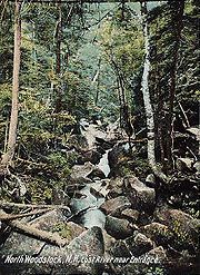
Basin and joins the Pemigewasset River in the village of North Woodstock
North Woodstock, New Hampshire
North Woodstock is a census-designated place in the town of Woodstock in Grafton County, New Hampshire. It had a population of 528 at the 2010 census....
.
New Hampshire Route 112
New Hampshire Route 112
New Hampshire Route 112 is a long east–west state highway in northern New Hampshire. The highway winds across the state, connecting Bath to Conway via the scenic and mountainous area of the White Mountain National Forest. Part of this highway, which runs through the White Mountains, is known as...
follows the Lost River/Moosilauke Brook for the stream's entire length.