
Lone Star, South Carolina
Encyclopedia
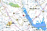
Lone Star is an unincorporated community
in Calhoun County
, South Carolina
, United States
. The community has the ZIP Code
of 29030 and lies at approximately 33.63 latitude
and -80.59 longitude
, with an elevation of 171 feet. It is part of the Columbia, South Carolina
Metropolitan Statistical Area
.
South Carolina Highway 33 runs between Lone Star and Orangeburg
.
Unincorporated area
In law, an unincorporated area is a region of land that is not a part of any municipality.To "incorporate" in this context means to form a municipal corporation, a city, town, or village with its own government. An unincorporated community is usually not subject to or taxed by a municipal government...
in Calhoun County
Calhoun County, South Carolina
Calhoun County is a county located in the U.S. state of South Carolina. In 2000, its population was 15,185; a 2005 Census Bureau estimate placed the population at 15,100. It is named for John C. Calhoun, the former U.S. Vice-President, Senator, Representative and cabinet member from South...
, South Carolina
South Carolina
South Carolina is a state in the Deep South of the United States that borders Georgia to the south, North Carolina to the north, and the Atlantic Ocean to the east. Originally part of the Province of Carolina, the Province of South Carolina was one of the 13 colonies that declared independence...
, United States
United States
The United States of America is a federal constitutional republic comprising fifty states and a federal district...
. The community has the ZIP Code
ZIP Code
ZIP codes are a system of postal codes used by the United States Postal Service since 1963. The term ZIP, an acronym for Zone Improvement Plan, is properly written in capital letters and was chosen to suggest that the mail travels more efficiently, and therefore more quickly, when senders use the...
of 29030 and lies at approximately 33.63 latitude
Latitude
In geography, the latitude of a location on the Earth is the angular distance of that location south or north of the Equator. The latitude is an angle, and is usually measured in degrees . The equator has a latitude of 0°, the North pole has a latitude of 90° north , and the South pole has a...
and -80.59 longitude
Longitude
Longitude is a geographic coordinate that specifies the east-west position of a point on the Earth's surface. It is an angular measurement, usually expressed in degrees, minutes and seconds, and denoted by the Greek letter lambda ....
, with an elevation of 171 feet. It is part of the Columbia, South Carolina
Columbia, South Carolina
Columbia is the state capital and largest city in the U.S. state of South Carolina. The population was 129,272 according to the 2010 census. Columbia is the county seat of Richland County, but a portion of the city extends into neighboring Lexington County. The city is the center of a metropolitan...
Metropolitan Statistical Area
Columbia, South Carolina metropolitan area
As defined by the U.S. Office of Management and Budget, and used by the U.S. Census Bureau for statistical purposes only, the Columbia Metropolitan Statistical Area, is an area consisting of six counties in central South Carolina, anchored by the city of Columbia. As of the 2000 census, the MSA had...
.
South Carolina Highway 33 runs between Lone Star and Orangeburg
Orangeburg, South Carolina
Orangeburg, also known as "The Garden City," is the principal city in and the county seat of Orangeburg County, South Carolina, United States. The city is also the fifth oldest city in the state of South Carolina. The city population was 12,765 at the 2000 census, within a Greater Orangeburg...
.