

Lolo Pass (Oregon)
Encyclopedia
Mountain pass
A mountain pass is a route through a mountain range or over a ridge. If following the lowest possible route, a pass is locally the highest point on that route...
6 miles (10 km) northwest of Mount Hood
Mount Hood
Mount Hood, called Wy'east by the Multnomah tribe, is a stratovolcano in the Cascade Volcanic Arc of northern Oregon. It was formed by a subduction zone and rests in the Pacific Northwest region of the United States...
and 10 miles (16.1 km) northeast of Zigzag, Oregon
Zigzag, Oregon
Zigzag is an unincorporated community in Clackamas County, Oregon, United States. It is located within the Mount Hood Corridor, between Rhododendron and Welches on U.S. Route 26...
, on the Clackamas
Clackamas County, Oregon
Clackamas County is a county located in the U.S. state of Oregon. The county was named after the Native Americans living in the area, the Clackamas Indians, who were part of the Chinookan people. As of 2010, the population was 375,992...
–Hood River
Hood River County, Oregon
-Demographics:As of the census of 2000, there were 20,411 people, 7,248 households, and 5,175 families residing in the county. The population density was 39 people per square mile . There were 7,818 housing units at an average density of 15 per square mile...
county line. It divides the Sandy River
Sandy River (Oregon)
The Sandy River is a tributary of the Columbia River in northwestern Oregon in the United States. Measured by a United States Geological Survey gauge downstream of the Sandy's confluence with the Bull Run River, from the mouth, the river's average discharge is . The maximum daily recorded flow...
watershed on the southwest from the Hood River watershed on the northeast.
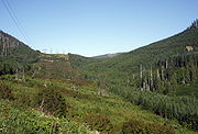
At 3415 feet (1,040.9 m), it provides a much lower crossing of the Cascade Range
Cascade Range
The Cascade Range is a major mountain range of western North America, extending from southern British Columbia through Washington and Oregon to Northern California. It includes both non-volcanic mountains, such as the North Cascades, and the notable volcanoes known as the High Cascades...
near Mount Hood
Mount Hood
Mount Hood, called Wy'east by the Multnomah tribe, is a stratovolcano in the Cascade Volcanic Arc of northern Oregon. It was formed by a subduction zone and rests in the Pacific Northwest region of the United States...
than the 4650 feet (1,417.3 m) Oregon Route 35 Bennett Pass on the southeast side. Access from the southwest side of the pass is paved all the way to the pass, where the road changes to gravel, heading down the northeast side of the pass.
The road through the pass was initially established by Native American
Native Americans in the United States
Native Americans in the United States are the indigenous peoples in North America within the boundaries of the present-day continental United States, parts of Alaska, and the island state of Hawaii. They are composed of numerous, distinct tribes, states, and ethnic groups, many of which survive as...
s, as a trading route connecting the Willamette Valley
Willamette Valley
The Willamette Valley is the most populated region in the state of Oregon of the United States. Located in the state's northwest, the region is surrounded by tall mountain ranges to the east, west and south and the valley's floor is broad, flat and fertile because of Ice Age conditions...
and sites at the eastern end of the Columbia River Gorge
Columbia River Gorge
The Columbia River Gorge is a canyon of the Columbia River in the Pacific Northwest of the United States. Up to deep, the canyon stretches for over as the river winds westward through the Cascade Range forming the boundary between the State of Washington to the north and Oregon to the south...
like Celilo Falls
Celilo Falls
Celilo Falls was a tribal fishing area on the Columbia River, just east of the Cascade Mountains, on what is today the border between the U.S. states of Oregon and Washington...
. In 1838, Daniel Lee (nephew of missionary Jason Lee
Jason Lee (missionary)
Jason Lee , an American missionary and pioneer, was born on a farm near Stanstead, Quebec. He was the first of the Oregon missionaries and helped establish the early foundation of a provisional government in the Oregon Country....
) drove livestock across the pass, while traveling east to establish a new Methodist mission
Methodist Mission
The Methodist Mission was founded in Oregon Country in 1834 by the Reverend Jason Lee. The mission was started to educate the Native Americans in the Willamette Valley and grew into an important center for politics and economics in the early settlement period of Oregon.-Foundation:In 1831, several...
at Wascopam. He was the first westerner
Western world
The Western world, also known as the West and the Occident , is a term referring to the countries of Western Europe , the countries of the Americas, as well all countries of Northern and Central Europe, Australia and New Zealand...
known to have used the trail. The trail was then used as one of the final legs of the Oregon Trail
Oregon Trail
The Oregon Trail is a historic east-west wagon route that connected the Missouri River to valleys in Oregon and locations in between.After 1840 steam-powered riverboats and steamboats traversing up and down the Ohio, Mississippi and Missouri rivers sped settlement and development in the flat...
; settlers arriving from The Dalles would often drive their livestock over the pass while their families floated down the river. The 1846 construction of the Barlow Road
Barlow Road
The Barlow Road is a historic road in what is now the U.S. state of Oregon. It was built in 1846 by Sam Barlow and Philip Foster, with authorization of the Provisional Legislature of Oregon, and served as the last overland segment of the Oregon Trail...
provided a less daunting alternate route around the south side of Mount Hood.
Lolo Pass is one of the milestones along the Pacific Crest Trail
Pacific Crest Trail
The Pacific Crest Trail is a long-distance mountain hiking and equestrian trail on the Western Seaboard of the United States. The southern terminus is at the California border with Mexico...
, though not a particularly low point for the region. By 5 miles (8 km) south of Lolo Pass, the Pacific Crest Trail drops to 2800 feet (853.4 m) and much lower to the north at the Columbia River. A small campsite is located along the trail just south of the forest service road.