

Little River County, Arkansas
Encyclopedia
Little River County is a county
located in the U.S. state
of Arkansas
. As of 2010, the population was 13,171. The county seat
is Ashdown
. Little River County is Arkansas's 59th county, formed from Sevier County on March 5, 1867, and named for the Little River
. The county is separated from all other surrounding counties in the state by water (a characteristic shared only with neighboring Miller County), with the Little River, Millwood Lake and the Red River
forming the boundaries of the county within the state.
Little River County is also one of several dry counties
within the state of Arkansas, prohibiting the sale of alcohol.
 As of the census
of 2000, there were 13,628 people, 5,465 households, and 3,912 families residing in the county. The population density
was 26 people per square mile (10/km²). There were 6,435 housing units at an average density of 12 per square mile (5/km²). The racial makeup of the county was 74.52% White
, 21.27% Black
or African American
, 1.45% Native American
, 0.20% Asian
, 0.03% Pacific Islander
, 0.86% from other races
, and 1.67% from two or more races. 1.72% of the population were Hispanic
or Latino
of any race.
There were 5,465 households out of which 31.40% had children under the age of 18 living with them, 55.60% were married couples
living together, 12.30% had a female householder with no husband present, and 28.40% were non-families. 26.30% of all households were made up of individuals and 12.00% had someone living alone who was 65 years of age or older. The average household size was 2.46 and the average family size was 2.95.
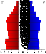
In the county the population was spread out with 25.20% under the age of 18, 8.40% from 18 to 24, 25.70% from 25 to 44, 25.60% from 45 to 64, and 15.10% who were 65 years of age or older. The median age was 38 years. For every 100 females there were 94.70 males. For every 100 females age 18 and over, there were 90.30 males.
The median income for a household in the county was $29,417, and the median income for a family was $36,207. Males had a median income of $32,489 versus $18,435 for females. The per capita income
for the county was $15,899. About 11.90% of families and 15.40% of the population were below the poverty line, including 18.80% of those under age 18 and 17.80% of those age 65 or over.
County (United States)
In the United States, a county is a geographic subdivision of a state , usually assigned some governmental authority. The term "county" is used in 48 of the 50 states; Louisiana is divided into parishes and Alaska into boroughs. Parishes and boroughs are called "county-equivalents" by the U.S...
located in the U.S. state
U.S. state
A U.S. state is any one of the 50 federated states of the United States of America that share sovereignty with the federal government. Because of this shared sovereignty, an American is a citizen both of the federal entity and of his or her state of domicile. Four states use the official title of...
of Arkansas
Arkansas
Arkansas is a state located in the southern region of the United States. Its name is an Algonquian name of the Quapaw Indians. Arkansas shares borders with six states , and its eastern border is largely defined by the Mississippi River...
. As of 2010, the population was 13,171. The county seat
County seat
A county seat is an administrative center, or seat of government, for a county or civil parish. The term is primarily used in the United States....
is Ashdown
Ashdown, Arkansas
Ashdown is a city in Little River County, Arkansas, United States. The population was 4,781 at the 2000 census. The city is the county seat of Little River County.-Geography:Ashdown is located at ....
. Little River County is Arkansas's 59th county, formed from Sevier County on March 5, 1867, and named for the Little River
Little River (Red River)
The Little River is a tributary of the Red River, about long, in southeastern Oklahoma and southwestern Arkansas in the United States. Via the Red, it is part of the watershed of the Mississippi River.-Course:...
. The county is separated from all other surrounding counties in the state by water (a characteristic shared only with neighboring Miller County), with the Little River, Millwood Lake and the Red River
Red River (Mississippi watershed)
The Red River, or sometimes the Red River of the South, is a major tributary of the Mississippi and Atchafalaya Rivers in the southern United States of America. The river gains its name from the red-bed country of its watershed. It is one of several rivers with that name...
forming the boundaries of the county within the state.
Little River County is also one of several dry counties
Dry county
A dry county is a county in the United States whose government forbids the sale of alcoholic beverages. Some prohibit off-premises sale, some prohibit on-premises sale, and some prohibit both. Hundreds of dry counties exist across the United States, almost all of them in the South...
within the state of Arkansas, prohibiting the sale of alcohol.
Geography
According to the 2000 census, the county has a total area of 564.87 square miles (1,463 km²), of which 531.73 square miles (1,377.2 km²) (or 94.13%) is land and 33.14 square miles (85.8 km²) (or 5.87%) is water.Major highways

 U.S. Highway 59/U.S. Highway 71
 Highway 32
 Highway 41
 Highway 108
Adjacent counties
- Sevier County (north)
- Howard CountyHoward County, ArkansasHoward County is a county located in the U.S. state of Arkansas. As of 2010, the population was 13,789. The county seat is Nashville. Howard County is Arkansas's 74th county, formed on April 17, 1873, and named for James Howard, a state senator...
(northeast) - Hempstead County (east)
- Miller County (southeast)
- Bowie CountyBowie County, TexasBowie County is a county located in the U.S. state of Texas. It is part of the Texarkana, Texas - Texarkana, Arkansas, Metropolitan Statistical Area. As of 2000, the population was 89,306. Its legal county seat is Boston, though its courthouse is located in New Boston...
, TexasTexasTexas is the second largest U.S. state by both area and population, and the largest state by area in the contiguous United States.The name, based on the Caddo word "Tejas" meaning "friends" or "allies", was applied by the Spanish to the Caddo themselves and to the region of their settlement in...
(south) - McCurtain CountyMcCurtain County, OklahomaMcCurtain County is a county located in the U.S. state of Oklahoma. As of 2010, the population was 33,151. Its county seat is Idabel.-Geography:...
, OklahomaOklahomaOklahoma is a state located in the South Central region of the United States of America. With an estimated 3,751,351 residents as of the 2010 census and a land area of 68,667 square miles , Oklahoma is the 28th most populous and 20th-largest state...
(west)
Demographics
Census
A census is the procedure of systematically acquiring and recording information about the members of a given population. It is a regularly occurring and official count of a particular population. The term is used mostly in connection with national population and housing censuses; other common...
of 2000, there were 13,628 people, 5,465 households, and 3,912 families residing in the county. The population density
Population density
Population density is a measurement of population per unit area or unit volume. It is frequently applied to living organisms, and particularly to humans...
was 26 people per square mile (10/km²). There were 6,435 housing units at an average density of 12 per square mile (5/km²). The racial makeup of the county was 74.52% White
Race (United States Census)
Race and ethnicity in the United States Census, as defined by the Federal Office of Management and Budget and the United States Census Bureau, are self-identification data items in which residents choose the race or races with which they most closely identify, and indicate whether or not they are...
, 21.27% Black
Race (United States Census)
Race and ethnicity in the United States Census, as defined by the Federal Office of Management and Budget and the United States Census Bureau, are self-identification data items in which residents choose the race or races with which they most closely identify, and indicate whether or not they are...
or African American
Race (United States Census)
Race and ethnicity in the United States Census, as defined by the Federal Office of Management and Budget and the United States Census Bureau, are self-identification data items in which residents choose the race or races with which they most closely identify, and indicate whether or not they are...
, 1.45% Native American
Race (United States Census)
Race and ethnicity in the United States Census, as defined by the Federal Office of Management and Budget and the United States Census Bureau, are self-identification data items in which residents choose the race or races with which they most closely identify, and indicate whether or not they are...
, 0.20% Asian
Race (United States Census)
Race and ethnicity in the United States Census, as defined by the Federal Office of Management and Budget and the United States Census Bureau, are self-identification data items in which residents choose the race or races with which they most closely identify, and indicate whether or not they are...
, 0.03% Pacific Islander
Race (United States Census)
Race and ethnicity in the United States Census, as defined by the Federal Office of Management and Budget and the United States Census Bureau, are self-identification data items in which residents choose the race or races with which they most closely identify, and indicate whether or not they are...
, 0.86% from other races
Race (United States Census)
Race and ethnicity in the United States Census, as defined by the Federal Office of Management and Budget and the United States Census Bureau, are self-identification data items in which residents choose the race or races with which they most closely identify, and indicate whether or not they are...
, and 1.67% from two or more races. 1.72% of the population were Hispanic
Race (United States Census)
Race and ethnicity in the United States Census, as defined by the Federal Office of Management and Budget and the United States Census Bureau, are self-identification data items in which residents choose the race or races with which they most closely identify, and indicate whether or not they are...
or Latino
Race (United States Census)
Race and ethnicity in the United States Census, as defined by the Federal Office of Management and Budget and the United States Census Bureau, are self-identification data items in which residents choose the race or races with which they most closely identify, and indicate whether or not they are...
of any race.
There were 5,465 households out of which 31.40% had children under the age of 18 living with them, 55.60% were married couples
Marriage
Marriage is a social union or legal contract between people that creates kinship. It is an institution in which interpersonal relationships, usually intimate and sexual, are acknowledged in a variety of ways, depending on the culture or subculture in which it is found...
living together, 12.30% had a female householder with no husband present, and 28.40% were non-families. 26.30% of all households were made up of individuals and 12.00% had someone living alone who was 65 years of age or older. The average household size was 2.46 and the average family size was 2.95.
In the county the population was spread out with 25.20% under the age of 18, 8.40% from 18 to 24, 25.70% from 25 to 44, 25.60% from 45 to 64, and 15.10% who were 65 years of age or older. The median age was 38 years. For every 100 females there were 94.70 males. For every 100 females age 18 and over, there were 90.30 males.
The median income for a household in the county was $29,417, and the median income for a family was $36,207. Males had a median income of $32,489 versus $18,435 for females. The per capita income
Per capita income
Per capita income or income per person is a measure of mean income within an economic aggregate, such as a country or city. It is calculated by taking a measure of all sources of income in the aggregate and dividing it by the total population...
for the county was $15,899. About 11.90% of families and 15.40% of the population were below the poverty line, including 18.80% of those under age 18 and 17.80% of those age 65 or over.
Cities and towns
|
Ogden, Arkansas Ogden is a town in Little River County, Arkansas, United States. The population was 214 at the 2000 census.-Geography:Ogden is located at .... Wilton, Arkansas Wilton is a town in Little River County, Arkansas, United States. The population was 439 at the 2000 census.-Geography:Wilton is located at .According to the United States Census Bureau, the town has a total area of , all land.-Demographics:... |
Winthrop, Arkansas Winthrop is a city in Little River County, Arkansas, United States. The population was 186 at the 2000 census. The city was also home of Winthrop Rockefeller's election campaigns.-Geography:Winthrop is located at .... |
Townships
- Arden
- Arkinda
- Burke
- Caney
- Cleveland (WiltonWilton, ArkansasWilton is a town in Little River County, Arkansas, United States. The population was 439 at the 2000 census.-Geography:Wilton is located at .According to the United States Census Bureau, the town has a total area of , all land.-Demographics:...
) - Franklin (CDP Yarborough LandingYarborough Landing, ArkansasYarborough Landing is a census-designated place in Little River County, Arkansas, United States. Its population was 487 as of the 2010 census....
) - Jackson (ForemanForeman, ArkansasForeman is a city in Little River County, Arkansas, United States. The population was 1,011 at the 2010 census.-Geography:Foreman is located at ....
) - Jeff Davis
- Jefferson (AshdownAshdown, ArkansasAshdown is a city in Little River County, Arkansas, United States. The population was 4,781 at the 2000 census. The city is the county seat of Little River County.-Geography:Ashdown is located at ....
) - Jewell
- Johnson (OgdenOgden, ArkansasOgden is a town in Little River County, Arkansas, United States. The population was 214 at the 2000 census.-Geography:Ogden is located at ....
) - Lick Creek
- Little River (WinthropWinthrop, ArkansasWinthrop is a city in Little River County, Arkansas, United States. The population was 186 at the 2000 census. The city was also home of Winthrop Rockefeller's election campaigns.-Geography:Winthrop is located at ....
) - Red River
- Richland
- Wallace