
.gif)
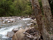
Little River (Ammonoosuc River)
Encyclopedia
Mile
A mile is a unit of length, most commonly 5,280 feet . The mile of 5,280 feet is sometimes called the statute mile or land mile to distinguish it from the nautical mile...
long (11.8 km
KM
KM, Km, or km may stand for:*Kilometre *Kernel methods*Kettle Moraine High School*Khmer language *Kuomintang , a centre-right political party in the Republic of China on Taiwan...
) river
River
A river is a natural watercourse, usually freshwater, flowing towards an ocean, a lake, a sea, or another river. In a few cases, a river simply flows into the ground or dries up completely before reaching another body of water. Small rivers may also be called by several other names, including...
in the White Mountains
White Mountains (New Hampshire)
The White Mountains are a mountain range covering about a quarter of the state of New Hampshire and a small portion of western Maine in the United States. Part of the Appalachian Mountains, they are considered the most rugged mountains in New England...
of New Hampshire
New Hampshire
New Hampshire is a state in the New England region of the northeastern United States of America. The state was named after the southern English county of Hampshire. It is bordered by Massachusetts to the south, Vermont to the west, Maine and the Atlantic Ocean to the east, and the Canadian...
in the United States
United States
The United States of America is a federal constitutional republic comprising fifty states and a federal district...
. It is a tributary of the Ammonoosuc River
Ammonoosuc River
The Ammonoosuc River is a river, 55 mi long, in northwestern New Hampshire in the United States. It is a tributary of the Connecticut River, which flows to Long Island Sound. "Ammonoosuc" is Abnaki for "small, narrow fishing place"....
and part of the Connecticut River
Connecticut River
The Connecticut River is the largest and longest river in New England, and also an American Heritage River. It flows roughly south, starting from the Fourth Connecticut Lake in New Hampshire. After flowing through the remaining Connecticut Lakes and Lake Francis, it defines the border between the...
watershed
Drainage basin
A drainage basin is an extent or an area of land where surface water from rain and melting snow or ice converges to a single point, usually the exit of the basin, where the waters join another waterbody, such as a river, lake, reservoir, estuary, wetland, sea, or ocean...
.
The Little River rises in the White Mountain National Forest
White Mountain National Forest
The White Mountain National Forest is a federally-managed forest contained within the White Mountains in the northeastern United States. It was established in 1918 as a result of the Weeks Act of 1911; federal acquisition of land had already begun in 1914. It has a total area of...
in a small glacial cirque
Cirque (landform)
thumb|250 px|Two cirques with semi-permanent snowpatches in [[Abisko National Park]], [[Sweden]].A cirque or corrie is an amphitheatre-like valley head, formed at the head of a valley glacier by erosion...
surrounded by Zealand Mountain to the east, Mount Guyot
Mount Guyot (New Hampshire)
Mount Guyot is a mountain located in Grafton County, New Hampshire. The mountain is named after Professor Arnold H. Guyot of Princeton University, and is part of the Twin Range of the White Mountains....
to the south, and South Twin Mountain
South Twin Mountain (New Hampshire)
South Twin Mountain is a mountain located in Grafton County, New Hampshire. The mountain is part of the Twin Range of the White Mountains. South Twin forms the high point of a north-south ridge, with North Twin Mountain lying approximately one mile to the north and Mount Guyot two miles to the...
to the west. The river flows north into the town of Bethlehem
Bethlehem, New Hampshire
Bethlehem is a hillside town in Grafton County, New Hampshire, United States. The population was 2,526 at the 2010 census. It is home to Cushman and Strawberry Hill state forests. The eastern half of the town is within the White Mountain National Forest...
, through a deep valley between North Twin Mountain
North Twin Mountain (New Hampshire)
North Twin Mountain is a mountain located in Grafton County, New Hampshire. The mountain forms the north end of the Twin Range of the White Mountains. North Twin overlooks the village of Twin Mountain, lying to the north of the mountain at the intersection of US Routes 3 and 302...
to the west and Mount Hale
Mount Hale (New Hampshire)
Mount Hale is a mountain located in Grafton County, New Hampshire. The mountain is named after Reverend Edward Everett Hale , and is part of the Twin Range of the White Mountains...
to the east. Eventually the river enters the town of Carroll
Carroll, New Hampshire
Carroll is a town in Coos County, New Hampshire, United States. The population was 763 at the 2010 census. The two largest villages are Twin Mountain and Bretton Woods. Carroll is an important access point for recreational areas in the White Mountains, including many 4,000-footers, the Zealand...
near the community of Twin Mountain
Twin Mountain, New Hampshire
Twin Mountain is a village within the town of Carroll in the White Mountains of New Hampshire. It is named for two prominent summits which rise to the south of the village, North Twin Mountain and South Twin Mountain ....
, passes under U.S. Route 3
U.S. Route 3
U.S. Route 3 is a north–south United States highway that runs from its southern terminus in Cambridge, Massachusetts through New Hampshire to its terminus near Third Connecticut Lake at the Canadian border, where the road continues north as Quebec Route 257.In New Hampshire parts of US 3 are...
, and ends at the Ammonoosuc River.
The Little River is a public water supply for the village of Twin Mountain. A portion of the river is paralleled by (and crossed three times by) the North Twin Trail, a hiking trail.