
List of windmills in Surrey
Encyclopedia
A list of all windmill
s and windmill sites which lie in the current ceremonial county
of Surrey
.
Windmill
A windmill is a machine which converts the energy of wind into rotational energy by means of vanes called sails or blades. Originally windmills were developed for milling grain for food production. In the course of history the windmill was adapted to many other industrial uses. An important...
s and windmill sites which lie in the current ceremonial county
Ceremonial counties of England
The ceremonial counties are areas of England to which are appointed a Lord Lieutenant, and are defined by the government as counties and areas for the purposes of the Lieutenancies Act 1997 with reference to the metropolitan and non-metropolitan counties of England and Lieutenancies Act 1997...
of Surrey
Surrey
Surrey is a county in the South East of England and is one of the Home Counties. The county borders Greater London, Kent, East Sussex, West Sussex, Hampshire and Berkshire. The historic county town is Guildford. Surrey County Council sits at Kingston upon Thames, although this has been part of...
.
A, B
| Location | Name of mill and grid reference |
Type | Maps | First mention or built |
Last mention or demise |
Photograph |
|---|---|---|---|---|---|---|
| Alfold Alfold Alfold is small village and civil parish on the Surrey/West Sussex border in England. The parish clerk is Mrs L.R. Enticknap.Originally sited perhaps for the glass making . Charcoal was extensively burnt in the parish for gunpowder works in Dunsfold, Cranleigh, and Sussex.Alfold is not mentioned in... |
Alfold Mill Laker’s Green Mill Tickner’s Heath Mill Robbin’s Mill Dunsfold Mill |
Smock Smock mill The smock mill is a type of windmill that consists of a sloping, horizontally weatherboarded tower, usually with six or eight sides. It is topped with a roof or cap that rotates to bring the sails into the wind... |
1871 | 1841 | Demolished 1913 | |
| Ash Ash, Surrey Ash is a village and civil parish in the borough of Guildford, Surrey, with a population of 17,549 according to the 2001 census. It is at the far west of the Guildford borough, and the urban development in the parish runs directly into Aldershot, which is on the western side of the River... |
Post | 1332 | 1332 | |||
| Banstead Banstead Banstead is a town in the borough of Reigate and Banstead in the county of Surrey, England, on the border with Greater London. It lies south of London, west of Croydon and of the county town of Kingston-Upon-Thames. Banstead is on the North Downs and is protected by the Metropolitan Green Belt;... |
Hundred Acres Mill | Post | 1816 | 1505 | Demolished c1877 | |
| Belmont Belmont, Sutton Belmont is a village in the London Borough of Sutton in southwest Greater London, England. It is located off the A217 road and near to Banstead Downs in Surrey. It is a suburban development situated 10.8 miles south-southwest of Charing Cross.... |
The Folly Mill | Smock | 1823 | 1823 | Demolished c1890 | |
| Birtley | Birtley Mill | 1834 | Demolished 1853 | |||
| Bletchingley Bletchingley Bletchingley is a village in Surrey, England. It is on the A25 road to the east of Redhill and to the west of Godstone.-History:The village lay within the Anglo-Saxon administrative division of Tandridge hundred.... |
Cox Hill Mill | Moved to Ifield, Sussex c1870 | ||||
| Buckland Buckland, Surrey Buckland is a village and civil parish in the Mole Valley district of Surrey, England. The village is situated between Dorking and Reigate. The civil parish of Buckland covers 515 hectares and is bordered by the North Downs escarpment in the north. The area contains a number of clay pits.Buckland... |
Buckland Windmill Buckland Windmill Buckland Windmill is a grade II listed smock mill at Buckland, Surrey, England which has been restored to working order. It is the only surviving wind saw mill in the United Kingdom.-History:... |
Smock | Windmill World | 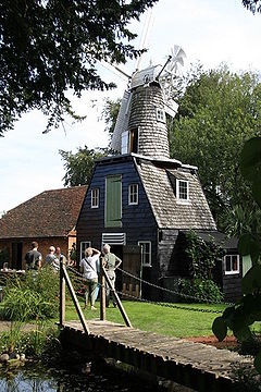 |
C
| Location | Name of mill and grid reference |
Type | Maps | First mention or built |
Last mention or demise |
Photograph |
|---|---|---|---|---|---|---|
| Capel | Clark’s Green Mill | Post | 1733 1749 1762 1777 1789 |
1649 | Demolished 1774 | |
| Capel | Shiremark Mill Shiremark Mill, Capel Shiremark Mill, also known as Kingsfold Mill or Capel Mill was a listed Smock mill at Capel, Surrey, England which was burnt down in 1972.-History:... |
Smock | 1774 | Burnt down 1970 Windmill World |
 |
|
| Carshalton Carshalton Carshalton is a suburban area of the London Borough of Sutton, England. It is located 10 miles south-southwest of Charing Cross, situated in the valley of the River Wandle, one of the sources of which is Carshalton Ponds in the centre of the village. The combined population of the five wards... |
1816 | 1816 | 1816 | |||
| Caterham Caterham Caterham is a town in the Tandridge District of Surrey, England. The town is geographically divided into two sections: Caterham on the Hill and Caterham Valley - the main town centre. The town lies close to the A22, a few miles south of Croydon, in a valley cut into the dip slope of the North Downs... |
Demolished before 1736 | |||||
| Caterham | Caterham Common mill | Post | 1696 | Standing in 1795, possibly demolished c1851. | ||
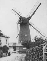
| Charlwood Charlwood Charlwood is a village and civil parish in the Mole Valley district of Surrey, England. It is immediately northwest of London Gatwick Airport in West Sussex, close west of Horley and north of Crawley. The historic county boundary between Surrey and Sussex ran to the south of Gatwick Airport... |
Stanhill Mill | Blown down 13 January 1703 | ||||
| Charlwood | Little Park Farm mill | Blown down 13 January 1703 | ||||
| Charlwood | Norwood Hill Mill | 1729 1750 |
1729 | 1750 | ||
| Charlwood | Charlwood Common Mill | Post | 1762 | 1762 | 1762 | |
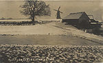
| Charlwood | Charlwood Common Mill | Smock | 1804 | Burnt down February 1901 | 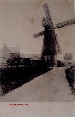 |
|
| Charlwood | Lowfield Heath Mill Lowfield Heath Windmill Lowfield Heath Windmill is a grade II listed post mill at Charlwood, Surrey, England which has been restored to working order.-History:Lowfield Heath Windmill was originally built at Lowfield Heath . Its origins are uncertain, a rumour that it was moved from Hookwood in the 1760s is not borne out... |
Post Mill | 1989 | Windmill World | 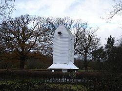 |
|
| Chelsham Chelsham Chelsham is a village in Surrey in the borough of Tandridge. It is within the civil parish of Chelsham and Farleigh.The village lay within the Anglo-Saxon administrative division of Tandridge hundred.... |
Chelsham mill | Post | 1762 1770 1823 |
1762 | Burnt down c1840 | |
| Chiddingfold Chiddingfold Chiddingfold is a village and civil parish in the heart of The Weald in the Waverley district of Surrey, England. It lies on the A283 between Milford and Petworth... |
1762 1789 |
1760 | 1796 | |||
| Chiddingfold | Hungry Corner Mill | Post | 1668 | Demolished c.1813 | ||
| Chiddingfold | Hungry Corner Mill | Smock | 1823 1871 |
1813 | Cap blown off c1874, demolished c1876 Windmill World |
|
| Chipstead | Mugswell Mill | 1790 | 1772 | 1790 | ||
| Chipstead | Mugswell Mill | Post | 1816 | Demolished c1912 Windmill World |
||
| Cobham Cobham, Surrey Cobham is a town in the Borough of Elmbridge in Surrey, England, about south-west of central London and north of Leatherhead. Elmbridge has been acclaimed by the Daily Mail as the best place to live in the UK, and Cobham is a prosperous part of the London commuter belt... |
Fairmile Mill | 1816 | c1805 | Demolished 1850s | ||
| Cranleigh Cranleigh Cranleigh is a large village, self-proclaimed the largest in England, and is situated 8 miles south east of Godalming in Surrey. It lies to the east of the A281 which links Guildford with Horsham; neighbouring villages include: Ewhurst, Alfold and Hascombe.... |
Windmill Field | |||||
| Cranleigh | Cranleigh Common Mill | Tower | 1753 | 1703 | Replaced by smock mill c1800 | |
| Cranleigh | Cranleigh Common Mill Killick’s Mill |
Smock | c1800 | Demolished February 1917 | 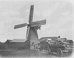 |
|
| Cranleigh | Cranley Mill | 1833 | Demolished 1853 |
D,E
| Location | Name of mill and grid reference |
Type | Maps | First mention or built |
Last mention or demise |
Photograph |
|---|---|---|---|---|---|---|
| Dorking Dorking Dorking is a historic market town at the foot of the North Downs approximately south of London, in Surrey, England.- History and development :... |
Popper Mill Pupper Mill |
1729 1749 |
1729 | 1749 | ||
| Epsom Wells Epsom Epsom is a town in the borough of Epsom and Ewell in Surrey, England. Small parts of Epsom are in the Borough of Reigate and Banstead. The town is located south-south-west of Charing Cross, within the Greater London Urban Area. The town lies on the chalk downland of Epsom Downs.-History:Epsom lies... |
early mill | C15th | C15th | |||
| Epsom Wells | Post | 1823 1871 |
1796 | Burnt down c1880 | ||
| Ewell Ewell Ewell is a village in the borough of Epsom and Ewell in Surrey, close to the southern boundary of Greater London. It is located 14 miles south-south-west of Charing Cross and forms part of the suburbia that surrounds Greater London. Despite its growing population it is still referred to as a... |
Tower | 1816 1853 |
1801 | Demolished c1900 | ||
| Ewhurst Ewhurst, Surrey Ewhurst is a small village in the English county of Surrey.Ewhurst is located between Cranleigh and Shere which is around five miles to the north. Ewhurst has many well-known legends as members of the village, such as Eric Clapton, who is known to play at the Church of England church in Ewhurst... |
Hurt Wood Mill | Post | 1733 1749 |
1648 | Standing in 1847, blown down c1854 | |
| Ewhurst | Hurt Wood Mill Hurt Wood Mill, Ewhurst Hurt Wood Mill is a grade II* listed tower mill at Ewhurst, Surrey, England which has been converted to residential use.-History:Hurt Wood Mill was built in the 1845, replacing a post mill that had been blown down. The post mill was standing in 1648. The mill worked by wind until c1885 and the ... |
Tower | 1871 | 1855 | Windmill World | 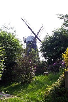 |
F, G, H
| Location | Name of mill and grid reference |
Type | Maps | First mention or built |
Last mention or demise |
Photograph |
|---|---|---|---|---|---|---|
| Fetcham Fetcham Fetcham is a village in Surrey, England. It is west of Leatherhead, on the other side of the River Mole and Mill Pond springs and the associated nature reserve.... |
Cheshire Mill | Tower | 1789 | 1777 | 1804 | |
| Frimley Frimley Frimley is a small English town situated 2 miles south of Camberley, in the extreme west of Surrey, adjacent to the border with Hampshire. It is about 31 miles west south-west of Central London. It is part of the Borough of Surrey Heath... |
early mill | 1537 | 1537 | |||
| Frimley | Frimley Green Mill Frimley Green Windmill Frimley Green Windmill is a Grade II listed tower mill at Frimley Green, Surrey, England which has been converted to residential use.-History:... |
Tower | 1816 | 1784 | Windmill World | |
| Godstone | Tilburstow Hill Mill | Post | 1762 1777 1790 1871 |
1760 | Collapsed 1805 | |
| Godstone | Godstone Green Mill | Post | 1816 1871 |
c1810 | Demolished late 1880s | |
| Haslemere Haslemere Haslemere is a town in Surrey, England, close to the border with both Hampshire and West Sussex. The major road between London and Portsmouth, the A3, lies to the west, and a branch of the River Wey to the south. Haslemere is approximately south-west of Guildford.Haslemere is surrounded by hills,... |
Grayswood Hill Mill Oliver’s Mill |
Smock | 1871 | 1785 | Demolished August 1886 | |
| Holmwood Holmwood Holmwood is a civil parish in Surrey, England. The parish has a population of 850.Holmwood forms part of Mole Valley Borough Council's area; the main settlements are North Holmwood and South Holmwood both of which are bypassed by the A24 road. The smaller settlement of Mid Holmwood is alongside the... |
Holmwood Mill | 1762 | ||||
| Holmwood | Holmwood Mill | Post | 1816 | 1775 | Demolished c1880 | |
| Hookwood | Hookwood Mill | Post | 1823 1866 |
c1820 | Demolished 1896 | |
| Horley Horley Horley is a town in Surrey, England, situated south of the twin towns of Reigate and Redhill, and north of Gatwick Airport and Crawley.With fast links by train to London from Horley railway station, it has grown popular with commuters in recent years... |
Horley mill | Post | 1762 1777 1789 1816 1871 |
1762 | Demolished c1900 | |
| Horne Horne, Surrey Horne is a village and civil parish in the District of Tandridge in Surrey, England. The parish includes the hamlet of Newchapel, and has a population of 805. The parish is located on the A22 road, east of Horley, west of Lingfield, south west of Oxted, and south of Kingston upon... |
Horne Mill | 1823 | 1823 | Standing in 1845, gone by 1851 | ||
| Horsell Horsell Horsell in Surrey is an ancient village nearby to the more modern 19th century Woking, probably best known because of its association with the story The War of the Worlds, written by H. G. Wells. It is the home of the book's narrator , and the landing site of the first Martian transport vessel... |
Saw mill | Post mill | 1890 | c1910 |
K, L
| Location | Name of mill and grid reference |
Type | Maps | First mention or built |
Last mention or demise |
Photograph |
|---|---|---|---|---|---|---|
| Kingston upon Thames Kingston upon Thames Kingston upon Thames is the principal settlement of the Royal Borough of Kingston upon Thames in southwest London. It was the ancient market town where Saxon kings were crowned and is now a suburb situated south west of Charing Cross. It is one of the major metropolitan centres identified in the... |
Kingston Mill | 1700 1733 |
1700 | 1733 | ||
| Leigh Leigh, Surrey Leigh is a village and civil parish in Surrey, between Reigate and Dorking.It is located in the Mole Valley district. The civil parish has a population of 856 and covers 1,382 hectares.... |
Shellwood Common Mill | 1729 1750 1762 1789 |
1729 | 1789, later burnt down, gone by 1795 | ||
| Leigh | Shellwood Common Mill | Post | 1816 1823 |
1795 | Standing in 1915, gone by 1925 | |
| Limpsfield Chart Limpsfield Limpsfield is a village and parish in the east of the county of Surrey, England near Oxted at the foot of the North Downs. It lies between the A25 to the south and the M25 motorway to the north, near the Clackett Lane service station... |
Post | 1816 | Demolished February 1925 | |||
| Long Ditton Long Ditton Long Ditton is a village in Surrey, England lying on the boundary with Greater London. Neighbouring settlements include Thames Ditton, Surbiton, Tolworth and Chessington.-History:... |
1762 | 1762 | 1762 |
M, N
| Location | Name of mill and grid reference |
Type | Maps | First mention or built |
Last mention or demise |
Photograph |
|---|---|---|---|---|---|---|
| Merstham Merstham Merstham is a village in the Reigate and Banstead borough of Surrey, England, in the London commuter belt. It is just north of Redhill, near the intersection of the M25 and M23 motorways, on the edge of the North Downs and on the North Downs Way.-History:... |
Post | 1789 1816 1823 1871 |
1786 | Demolished 7 October 1896 | ||
| Mitcham Mitcham Mitcham is a district in the south west area of London, in the London Borough of Merton. A suburban area, Mitcham is located on the border of Inner London and Outer London. It is both residentially and financially developed, well served by Transport for London, and home to Mitcham Town Centre,... |
Mitcham Common Mill | Post | 1806 | Demolished 1906 | ||
| Mitcham | Horizontal | |||||
| Nutfield Nutfield, Surrey Nutfield is a village and civil parish in the Tandridge district of Surrey. It has a population of 2,728The village lay within the Reigate hundred.... |
Post mill | 1296 | 1296 | |||
| Nutfield | Botterys Mill | Post | 1680 | Demolished December 1929 |
O, R
| Location | Name of mill and grid reference |
Type | Maps | First mention or built |
Last mention or demise |
Photograph |
|---|---|---|---|---|---|---|
| Ockley Ockley Ockley is a historic village in Surrey, built on Stane Street, a Roman Road stretching from Chichester to London. Situated between Dorking and Horsham, close to the Sussex/Surrey border, Ockley nestles in the shadows of Leith Hill, the highest point in South east England. Neighbouring villages... |
Emler Mill Almer’s Mill |
Smock | 1823 | 1803 | Collapsed 23 November 1944 Windmill World |
 |
| Outwood Outwood, Surrey Outwood is a village in the Surrey weald. It is home to the oldest working windmill in England. The village lies to the east of the M23 which runs between the M25 and London Gatwick Airport. A neighbouring village is Smallfield.... |
Outwood Mill Outwood Windmill Outwood Windmill is a Grade I listed post mill in Outwood, Surrey. Built in 1665 by Thomas Budgen, a miller from Nutfield in Surrey, it is Britain's oldest working windmill.... |
Post | 1665 | Windmill World |  |
|
| Outwood | Outwood High Mill | Smock | 1796 | Collapsed 25 November 1960 | ||
| Reigate Reigate Reigate is a historic market town in Surrey, England, at the foot of the North Downs, and in the London commuter belt. It is one of the main constituents of the Borough of Reigate and Banstead... |
Oatmill | 1800 | 1800 | |||
| Reigate | Blackborough Mill | 1700 1729 1733 |
1700 | 1733, replaced by later post mill on same site | ||
| Reigate | Blackborough Mill, Blackberry Mill, Ganders Hatch Mill |
Post | 1736 | Demolished 1938 | ||
| Reigate | Cockshot Hill Mill | 1628 | Collapsed by 1639 | |||
| Reigate | Cockshot Hill Mill | Post | 1729 | 1729 | Standing in 1826, gone by 1845 | |
| Reigate | Cockshot Hill Mill | Post | 1748 | Demolished c1893 | ||
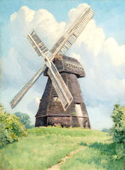
| Reigate | Reigate Heath Mill Reigate Heath Windmill Reigate Heath Windmill is a grade II* listed post mill at Reigate Heath, Surrey, England which has been restored and is used as a chapel. It is thought to be the only windmill in the world which is a consecrated church.-History:... |
Post | 1753 1762 |
1753 | Windmill World | 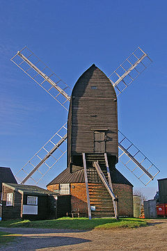 |
| Reigate | Trumpet’s Hill Mill | Smock | 1789 1816 1823 1871 |
Built 1760s | Demolished 4 October 1950 | 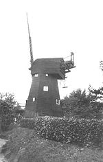 |
| Reigate | Wray Common Mill Wray Common Mill, Reigate Wray Common Mill is a grade II* listed tower mill at Reigate, Surrey, England which has been converted to residential use.-History:Wray Common Mill was built in 1824. The mill was worked by wind until 1895 when an accident resulted in a broken sail. The mill had a steam engine, later replaced by an... |
Tower | 1824 | Windmill World | 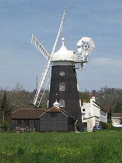 |
S
| Location | Name of mill and grid reference |
Type | Maps | First mention or built |
Last mention or demise |
Photograph |
|---|---|---|---|---|---|---|
| Shepperton Shepperton Shepperton is a town in the borough of Spelthorne, Surrey, England. To the south it is bounded by the river Thames at Desborough Island and is bisected by the M3 motorway... |
Upper Halliford | C14th | C14th | |||
| Shepperton | Halliford | 1382 | 1399 | |||
| Shepperton | Walton Bridge Approximately |
1597 | 1597 | |||
| South Beddington | Smock | 1835 | Burnt down 1852 | |||
| Sunbury on Thames | 1311 | 1311 | ||||
| Sunbury on Thames | 1591 | 1603 | ||||
| Sunbury on Thames | 1683 | Burnt down c1705 | ||||
| Sunbury on Thames | 1712 | 1722 | ||||
| Sunbury on Thames | Smock | 1819 | Demolished 1900s |
T, W
| Location | Name of mill and grid reference |
Type | Maps | First mention or built |
Last mention or demise |
Photograph |
|---|---|---|---|---|---|---|
| Tadworth Tadworth Tadworth is a large suburban village in Surrey, on the south-east slope of Epsom Downs. It forms part of the Borough of Reigate and Banstead. The census area Tadworth and Walton has a population of 7,016. Neighbouring settlements include Walton-on-the-Hill, Kingswood, Epsom, Burgh Heath, Banstead,... |
Post | 1295 | 1295 | |||
| Tadworth | Post | 1600 | 1775 | |||
| Tadworth | New Mill New Mill, Tadworth New Mill is a grade II listed post mill at Tadworth, Surrey, England which is on the Buildings at Risk Register.-History:The date that New Mill was built is not known, but is thought to have been in the mid eighteenth century. A windmill was recorded at Walton on the Hill in 1295, The earliest in... |
Post | 1780 | Windmill World | 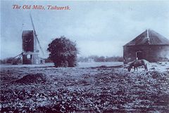 |
|
| Tadworth | Post | 1795 | Demolished 1890 | |||
| Walton-on-Thames Walton-on-Thames Walton-on-Thames is a town in the Elmbridge borough of Surrey in South East England. The town is located south west of Charing Cross and is between the towns of Weybridge and Molesey. It is situated on the River Thames between Sunbury Lock and Shepperton Lock.- History :The name "Walton" is... |
C18th or earlier |
|||||
| Walton-on-Thames | 1765 | 1765 | 1820 | |||
| Warlingham Warlingham Warlingham is a large village on the south-eastern boundary of London, England, just across the border in Tandridge district, east Surrey. Neighbouring villages include Sanderstead, Hamsey Green, Whyteleafe, Farleigh, Fickleshole, Tatsfield and Woldingham... |
Succombs Hill | Post | 1198 | 1325 | ||
| Warlingham | Ashby’s Mill | Smock | 1865 | Burnt down 24 April 1865 | ||
| Warlingham | Farleigh Mill | |||||
| West Horsley West Horsley West Horsley is a small village between Guildford and Leatherhead in Surrey, England. Neighbouring villages include East Horsley, Ockham, West Clandon and East Clandon. It lies on the A246, and south of the M25 and the A3. The Sheepleas Woods are located in the extreme south of the village, and... |
Windmill Hill Mill | Tower | 1729 1753 1762 1777 1790 |
1729 | Demolished 1866 | |
| Weybridge Weybridge Weybridge is a town in the Elmbridge district of Surrey in South East England. It is bounded to the north by the River Thames at the mouth of the River Wey, from which it gets its name... |
Conduit Hill | Tower | 1847 | 1847 | ||
| Windlesham Windlesham Windlesham is a village in the Surrey Heath district of Surrey in South East England. It is also the name of the parish that covers Bagshot and Lightwater, in addition to Windlesham... |
Post |
Locations formerly in Surrey
- For windmills in AddingtonAddington, LondonAddington is a district of south London, England, located in the London Borough of Croydon. It is situated south south-east of Charing Cross.-History:...
, Barnes, BatterseaBatterseaBattersea is an area of the London Borough of Wandsworth, England. It is an inner-city district of South London, situated on the south side of the River Thames, 2.9 miles south-west of Charing Cross. Battersea spans from Fairfield in the west to Queenstown in the east...
, BermondseyBermondseyBermondsey is an area in London on the south bank of the river Thames, and is part of the London Borough of Southwark. To the west lies Southwark, to the east Rotherhithe, and to the south, Walworth and Peckham.-Toponomy:...
, BrixtonBrixtonBrixton is a district in the London Borough of Lambeth in south London, England. It is south south-east of Charing Cross. The area is identified in the London Plan as one of 35 major centres in Greater London....
, CamberwellCamberwellCamberwell is a district of south London, England, and forms part of the London Borough of Southwark. It is a built-up inner city district located southeast of Charing Cross. To the west it has a boundary with the London Borough of Lambeth.-Toponymy:...
, CamerwellPeckhamPeckham is a district in south London, England, located in the London Borough of Southwark. It is situated south-east of Charing Cross. The area is identified in the London Plan as one of 35 major centres in Greater London...
, ClaphamClaphamClapham is a district in south London, England, within the London Borough of Lambeth.Clapham covers the postcodes of SW4 and parts of SW9, SW8 and SW12. Clapham Common is shared with the London Borough of Wandsworth, although Lambeth has responsibility for running the common as a whole. According...
, CoulsdonCoulsdonCoulsdon is a town on the southernmost boundary of the London Borough of Croydon. It is surrounded by the Metropolitan Green Belt of the Farthing Down, Coulsdon Common and Kenley Common...
, CroydonCroydonCroydon is a town in South London, England, located within the London Borough of Croydon to which it gives its name. It is situated south of Charing Cross...
, KewKewKew is a place in the London Borough of Richmond upon Thames in South West London. Kew is best known for being the location of the Royal Botanic Gardens, now a World Heritage Site, which includes Kew Palace...
, LambethLambethLambeth is a district of south London, England, and part of the London Borough of Lambeth. It is situated southeast of Charing Cross.-Toponymy:...
, NewingtonNewington, LondonNewington is a district of London, England, and part of the London Borough of Southwark. It was an ancient parish and the site of the early administration of the county of Surrey...
, NorwoodSouth NorwoodSouth Norwood is an urban town and in south London, England, in the London Borough of Croydon. It is a suburban development 7.8 miles south-east of Charing Cross. South Norwood is an electoral with a resident population in 2001 of just over 14,000...
, Richmond, RotherhitheRotherhitheRotherhithe is a residential district in inner southeast London, England and part of the London Borough of Southwark. It is located on a peninsula on the south bank of the Thames, facing Wapping and the Isle of Dogs on the north bank, and is a part of the Docklands area...
, ShirleyShirley, LondonShirley is a place in the London Borough of Croydon, England. It is a suburban development situated 10 miles south south-east of Charing Cross.-Description:...
, SouthwarkSouthwarkSouthwark is a district of south London, England, and the administrative headquarters of the London Borough of Southwark. Situated east of Charing Cross, it forms one of the oldest parts of London and fronts the River Thames to the north...
, StreathamStreathamStreatham is a district in Surrey, England, located in the London Borough of Lambeth. It is situated south of Charing Cross. The area is identified in the London Plan as one of 35 major centres in Greater London.-History:...
, SurbitonSurbitonSurbiton, a suburban area of London in the Royal Borough of Kingston upon Thames, is situated next to the River Thames, with a mixture of Art-Deco courts, more recent residential blocks and grand, spacious 19th century townhouses blending into a sea of semi-detached 20th century housing estates...
, WandsworthWandsworthWandsworth is a district of south London, England, in the London Borough of Wandsworth. It is situated southwest of Charing Cross. The area is identified in the London Plan as one of 35 major centres in Greater London.-Toponymy:...
and WimbledonWimbledon, LondonWimbledon is a district in the south west area of London, England, located south of Wandsworth, and east of Kingston upon Thames. It is situated within Greater London. It is home to the Wimbledon Tennis Championships and New Wimbledon Theatre, and contains Wimbledon Common, one of the largest areas...
see List of windmills in Greater London. - For windmills in Lowfield HeathLowfield HeathLowfield Heath is a former village within the boundaries of the Borough of Crawley, a local government district with Borough status in West Sussex, England. Situated on the main London to Brighton road approximately south of London and north of Crawley, it was gradually rendered uninhabitable by...
see List of windmills in West Sussex.
Maps
The maps quoted by date are:-- 1594 – John NordenJohn NordenJohn Norden was an English cartographer, chorographer and antiquary. He planned a series of county maps and accompanying county histories of England, the Speculum Britanniae...
- 1604 – Charles Whitewell
- 1610 - John SpeedJohn SpeedJohn Speed was an English historian and cartographer.-Life:He was born at Farndon, Cheshire, and went into his father's tailoring business where he worked until he was about 50...
- 1635 – Moses Glover
- 1658 - William FaithorneWilliam FaithorneWilliam Faithorne , often "the Elder", , English painter and engraver, was born in London and was apprenticed to William Peake....
- 1719 - Dr Harris
- 1729 – John Sennex
- 1733 – John Seller
- 1746 – John RocqueJohn RocqueJohn Rocque was a surveyor and cartographer.Rocque was born no later than 1709, since that was the year he moved to England with his parents, who were French Huguenot émigrés...
- 1750 - Bowen
- 1753 – Emanuel BowenEmanuel BowenEmanuel Bowen was an English map engraver, who worked for George II of England and Louis XV of France as a geographerHe published a 'Complete Atlas of Geography,' 1744-7; an 'English Atlas, with a new set of maps,' 1745; a 'Complete Atlas .....
- 1762 – John Rocque
- 1777 – Andrews and Dury
- 1789 – Lindley and Crosley
- 1800 – Laurie and Whittle
- 1816- Ordnance SurveyOrdnance SurveyOrdnance Survey , an executive agency and non-ministerial government department of the Government of the United Kingdom, is the national mapping agency for Great Britain, producing maps of Great Britain , and one of the world's largest producers of maps.The name reflects its creation together with...
- 1820 – Ordnance Survey
- 1823 - Bryant
- 1833 – Bryant and/or Greenwood
- 1850 – C Knight
- 1863 – Ordnance Survey
- 1871 - Ordnance Survey