
Outwood, Surrey
Encyclopedia
Outwood is a village
in the Surrey weald
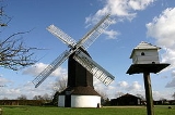
. It is home to the oldest working windmill in England
. The village lies to the east of the M23
which runs between the M25
and London Gatwick Airport
. A neighbouring village is Smallfield
.
Outwood has many walks ranging from short ones around the common to several miles of public National Trust
footpaths and bridleways. The paths take you through open common, woodland and fields. A large proportion of the countryside in and around Outwood is part of the Harewoods estate, which is owned and managed by the National Trust.
There are two main National Trust parking areas. One is opposite the main entrance to the windmill
and the other is on the track leading to the cricket
pitch on Outwood common, where there is a National Trust noticeboard showing a number of the footpaths. The National Trust holds guided walks at certain times of the year.
The paths take you through open common, woodland and fields, which are constantly changing through the seasons. A large proportion of the countryside in and around Outwood is part of the Harewoods estate, which is owned and managed by the National Trust.
There are two main National Trust parking areas. One is opposite the main entrance to the windmill and the other is on the track leading to the Cricket pitch on Outwood common, where there is a National Trust noticeboard showing a number of the footpaths.
The National Trust holds guided walks at certain times of the year. Please check the following link for details. http://www.nationaltrust.org.uk
1665 The Post Mill, still in working order, was built.
1834 The Baptist Chapel, no longer in use, was built.
1869 St John the Baptist Church was built.
1870 The creation of the ecclesiastical parish of St John the Baptist.
1876 The school was opened – now converted into apartments.
1887 Outwood Cricket Club was formed and is still active.
1891 The census of that year recorded about 586 residents in Outwood and 140 houses.
1930 Outwood Drama Society was formed, now defunct.
1936 The village hall was built, called the Lloyd Hall.
2000 Outwood Parish Council was created.
2001 Census recorded 569 People (309m, 260f), 224 households (Tandridge Census).
Village
A village is a clustered human settlement or community, larger than a hamlet with the population ranging from a few hundred to a few thousand , Though often located in rural areas, the term urban village is also applied to certain urban neighbourhoods, such as the West Village in Manhattan, New...
in the Surrey weald
Weald
The Weald is the name given to an area in South East England situated between the parallel chalk escarpments of the North and the South Downs. It should be regarded as three separate parts: the sandstone "High Weald" in the centre; the clay "Low Weald" periphery; and the Greensand Ridge which...
. It is home to the oldest working windmill in England
Outwood Windmill
Outwood Windmill is a Grade I listed post mill in Outwood, Surrey. Built in 1665 by Thomas Budgen, a miller from Nutfield in Surrey, it is Britain's oldest working windmill....
. The village lies to the east of the M23
M23 motorway
The M23 motorway is a motorway in England. The motorway runs from south of Hooley in Surrey, where it splits from the A23, to Pease Pottage, south of Crawley in West Sussex where it rejoins the A23. The northern end of the motorway starts at junction 7 on what is effectively a spur north from...
which runs between the M25
M25 motorway
The M25 motorway, or London Orbital, is a orbital motorway that almost encircles Greater London, England, in the United Kingdom. The motorway was first mooted early in the 20th century. A few sections, based on the now abandoned London Ringways plan, were constructed in the early 1970s and it ...
and London Gatwick Airport
London Gatwick Airport
Gatwick Airport is located 3.1 miles north of the centre of Crawley, West Sussex, and south of Central London. Previously known as London Gatwick,In 2010, the name changed from London Gatwick Airport to Gatwick Airport...
. A neighbouring village is Smallfield
Smallfield
Smallfield is a village located in Surrey, England. The village is part of the census area Burstow which has a population of 4,301.Smallfield lies to the east of the M23 which runs between the M25 and London Gatwick Airport...
.
Outwood has many walks ranging from short ones around the common to several miles of public National Trust
National Trust for Places of Historic Interest or Natural Beauty
The National Trust for Places of Historic Interest or Natural Beauty, usually known as the National Trust, is a conservation organisation in England, Wales and Northern Ireland...
footpaths and bridleways. The paths take you through open common, woodland and fields. A large proportion of the countryside in and around Outwood is part of the Harewoods estate, which is owned and managed by the National Trust.
There are two main National Trust parking areas. One is opposite the main entrance to the windmill
Windmill
A windmill is a machine which converts the energy of wind into rotational energy by means of vanes called sails or blades. Originally windmills were developed for milling grain for food production. In the course of history the windmill was adapted to many other industrial uses. An important...
and the other is on the track leading to the cricket
Cricket
Cricket is a bat-and-ball game played between two teams of 11 players on an oval-shaped field, at the centre of which is a rectangular 22-yard long pitch. One team bats, trying to score as many runs as possible while the other team bowls and fields, trying to dismiss the batsmen and thus limit the...
pitch on Outwood common, where there is a National Trust noticeboard showing a number of the footpaths. The National Trust holds guided walks at certain times of the year.
Walking in Outwood
Outwood Is a wonderful place to go walking, ranging from a short walk around the common to several miles of public, National Trust footpaths and bridleways.The paths take you through open common, woodland and fields, which are constantly changing through the seasons. A large proportion of the countryside in and around Outwood is part of the Harewoods estate, which is owned and managed by the National Trust.
There are two main National Trust parking areas. One is opposite the main entrance to the windmill and the other is on the track leading to the Cricket pitch on Outwood common, where there is a National Trust noticeboard showing a number of the footpaths.
The National Trust holds guided walks at certain times of the year. Please check the following link for details. http://www.nationaltrust.org.uk
Outwood’s history
1542 Earliest known reference to Outwood; the Court Roll refers to the restrictions concerning the felling of timber in Outwood.1665 The Post Mill, still in working order, was built.
1834 The Baptist Chapel, no longer in use, was built.
1869 St John the Baptist Church was built.
1870 The creation of the ecclesiastical parish of St John the Baptist.
1876 The school was opened – now converted into apartments.
1887 Outwood Cricket Club was formed and is still active.
1891 The census of that year recorded about 586 residents in Outwood and 140 houses.
1930 Outwood Drama Society was formed, now defunct.
1936 The village hall was built, called the Lloyd Hall.
2000 Outwood Parish Council was created.
2001 Census recorded 569 People (309m, 260f), 224 households (Tandridge Census).
External links
- http://www.outwood.info/
- http://www.outwood.org/
- http://www.outwoodmill.com/