
List of trails in New York
Encyclopedia
New York has a large network of multi-use paths, hiking trails, and other facilities. Many are short, local paths, but many are of statewide or regional significance.
 Before the railroad era, New York had an extensive network of canals. The towpath
s of several have been converted to multi-use paths. Some follow canals that are still in use, serving mostly recreational boating. Other towpath trails pass by the ruins of abandoned locks and other structures. A partnership of national, state, local and non-profit organizations is working to develop a continuous system of trails along the Erie, Oswego, Cayuga-Seneca, and Champlain canals. Among the organizations involved are Parks & Trails New York, the NYS Canal Corporation and the Erie Canalway National Heritage Corridor. When complete, the system will include 524 miles of trials.
Some of the completed sections include:
Other trails
Although many of the multi-use paths in New York are converted rail trails, there are some significant examples that were never railroads.- List of trails on Long Island, New York
- Trails in Ithaca, New YorkTrails in Ithaca, New York-Multiuse and commuter trails:Many of the major trails in Ithaca and the surrounding areas lie in abandoned railway beds. Ithaca was part of the first big railroad boom in the 1830s...
- Manhattan Waterfront GreenwayManhattan Waterfront GreenwayThe Manhattan Waterfront Greenway is a foreshoreway for walking or cycling, long, around the island of Manhattan. The largest portions are operated by the New York City Department of Parks. It is separated from motor traffic, and many sections also separate pedestrians from cyclists...
- Brooklyn-Queens GreenwayBrooklyn-Queens GreenwayThe Brooklyn-Queens Greenway is a bicycling and pedestrian path connecting parks and roads in the New York City boroughs of Brooklyn and Queens, connecting Coney Island in the south to Fort Totten in the north, on Long Island Sound...
- Blue Disc Trail (Harriman State Park)Blue Disc Trail (Harriman State Park)The Blue Disc Trail is a marked trail in Harriman State Park. The trail is long, connecting Johnsontown Road to the Ramapo-Dunderberg and Victory Trails. The blaze of the trail is a white blaze with a blue dot on it. The trail climbs two mountains, Almost Perpendicular & Pound Mountain, and passes...
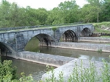
New York State Canalway Trail
Towpath
A towpath is a road or trail on the bank of a river, canal, or other inland waterway. The purpose of a towpath is to allow a land vehicle, beasts of burden, or a team of human pullers to tow a boat, often a barge...
s of several have been converted to multi-use paths. Some follow canals that are still in use, serving mostly recreational boating. Other towpath trails pass by the ruins of abandoned locks and other structures. A partnership of national, state, local and non-profit organizations is working to develop a continuous system of trails along the Erie, Oswego, Cayuga-Seneca, and Champlain canals. Among the organizations involved are Parks & Trails New York, the NYS Canal Corporation and the Erie Canalway National Heritage Corridor. When complete, the system will include 524 miles of trials.
Some of the completed sections include:
- Glens Falls Feeder Canal Trail, 9 miles long
- Old Champlain Canal Trail
- Old Erie Canal State Historic ParkOld Erie Canal State Historic ParkOld Erie Canal State Historic Park is a part of the New York State Park system. It is a linear park encompassing a 36-mile segment of the original Erie Canal's Long Level section, and extends eastward from Butternut Creek in the town of Dewitt, New York, east of Syracuse, to just outside of the...
trail, 30 miles long, from Dewitt to Rome, New YorkRome, New YorkRome is a city in Oneida County, New York, United States. It is located in north-central or "upstate" New York. The population was 44,797 at the 2010 census. It is in New York's 24th congressional district. In 1758, British forces began construction of Fort Stanwix at this strategic location, but... - Camillus Erie Canal ParkCamillus Erie Canal ParkCamillus Erie Canal Park is a town park in Camillus, New York that preserves a seven mile stretch of the Erie Canal. It includes the Nine Mile Creek Aqueduct, which is listed on the National Register of Historic Places...
trail - Mohawk Hudson Hike/Bike TrailMohawk Hudson Hike/Bike TrailThe Mohawk Hudson Hike/Bike Trail is a trail in Albany and Schenectady counties in New York's Capital District. It is also the easternmost segment of the New York State Canalway Trail....
, 40 miles long, from Fort Hunter to Albany, New YorkAlbany, New YorkAlbany is the capital city of the U.S. state of New York, the seat of Albany County, and the central city of New York's Capital District. Roughly north of New York City, Albany sits on the west bank of the Hudson River, about south of its confluence with the Mohawk River... - Erie Canal Heritage Trail, 70 miles long, from Lockport to Palmyra
Long distance hiking trails
- The Long PathLong PathThe Long Path is a long-distance hiking trail beginning at the George Washington Bridge in Fort Lee, New Jersey and currently ending at Altamont, New York, in the Albany area...
- The Appalachian TrailAppalachian TrailThe Appalachian National Scenic Trail, generally known as the Appalachian Trail or simply the AT, is a marked hiking trail in the eastern United States extending between Springer Mountain in Georgia and Mount Katahdin in Maine. It is approximately long...
- the Taconic Crest TrailTaconic Crest TrailThe Taconic Crest Trail is a hiking trail in the Taconic Mountains of the Berkshires. The trail extends from U.S. Route 20 in Hancock, Massachusetts, less than east of the New York border, north along the ridgecrest of the Taconic Range, first within Massachusetts, then weaving along the border...
- the Finger Lakes TrailFinger Lakes TrailThe Finger Lakes Trail System consists of a network of trails in New York. The trail system is administered by the , a non-profit, volunteer organization....
- the Northville-Placid TrailNorthville-Placid TrailThe Northville-Lake Placid Trail, also known as the NPT, is a lightly travelled foot trail that runs 133 mi through the Adirondack Park in northern New York State. It was laid out by the Adirondack Mountain Club in 1922 and 1923, and is now maintained by the New York State Department of...
Proposed trails
- The Albany County Rail Trail will use an old Delaware and Hudson RailwayDelaware and Hudson RailwayThe Delaware and Hudson Railway is a railroad that operates in the northeastern United States. Since 1991 it has been a subsidiary of the Canadian Pacific Railway, although CPR has assumed all operations and the D&H does not maintain any locomotives or rolling stock.It was formerly an important...
right-of-way from the Port of AlbanyPort of Albany-RensselaerThe Port of Albany–Rensselaer, widely known as the Port of Albany, is a port of entry in the United States with facilities on both sides of the Hudson River in Albany and Rensselaer, New York. Private and public port facilities have existed in both cities since the 17th century, with an increas in...
to Voorheesville, NY. This is part of the Albany and Susquehanna RailroadAlbany and Susquehanna RailroadThe Albany and Susquehanna Railroad was a railroad running from Albany to Binghamton, operating 1851 to 1870-History:Construction began on April 19, 1851 from Albany to Schoharie Junction, New York, a distance of 35 miles . This phase was completed in 1863...
line. It was originally called the Hudson-to-Helderberg Trail, since it was intended to extend as far as Delanson, NY, but the rail line is still in use west of Voorheesville. First proposed in 1995, the County of Albany and CP Rail finally signed the property purchase agreement in December, 2008. The trail is currently being designed, with construction expected during 2010.
- The Patroon Creek Trail is intended to run parallel to the Patroon CreekPatroon CreekPatroon Creek is a stream in Albany County, New York, United States and is a tributary of the Hudson River which flows south to New York Harbor and the Atlantic Ocean. The creek's source is Rensselaer Lake in the western section of the city of Albany and flows along the northern border of said city...
and Interstate 90Interstate 90Interstate 90 is the longest Interstate Highway in the United States at . It is the northernmost coast-to-coast interstate, and parallels US 20 for the most part. Its western terminus is in Seattle, at Edgar Martinez Drive S. near Safeco Field and CenturyLink Field, and its eastern terminus is in...
, connecting several regional and local parks, including the Erastus Corning Preserve, the Tivoli Lake Preserve, Six Mile WaterworksRensselaer LakeRensselaer Lake is an artificial lake in Albany, New York, United States named for Major-General Stephen Van Rensselaer, last patroon of Rensselaerswyck. The lake was Albany's first municipally-owned source of water. It is part of a park and the state's Albany Pine Bush Preserve...
Park, and the Pine Bush Preserve. An application for Transportation Enhancement Program funding for the section from Tivoli Lake to Six Mile Waterworks was submitted in June, 2008, but was not selected for this round of funding.
External links
- Canalway Hiking and Biking Trails http://www.nycanal.com/recreation/hikebikemain.html
- Capital District Regional Bike-Hike Map: http://www.cdtcmpo.org/regbkmap.htm
- 2004 Mohawk-Hudson Bike-Hike Trail Map: http://www.cdtcmpo.org/mhbkmap.htm
- Tech Valley Trails: A Greenways Concept Plan for the Capital Region, Capital District Transportation Committee, 2007, http://www.cdtcmpo.org/rtp2030/c-greenways.pdf (23 Mb)