
.gif)
Blue Disc Trail (Harriman State Park)
Encyclopedia
The Blue Disc Trail is a marked trail in Harriman State Park. The trail is 2.8 miles (4.5 km) long, connecting Johnsontown Road to the Ramapo-Dunderberg and Victory Trails. The blaze of the trail is a white blaze with a blue dot on it. The trail climbs two mountains, Almost Perpendicular & Pound Mountain, and passes two major rock formations, Elbow Brush and Claudius Smith Rock. The trail dates back to the 1920s with the Tuxedo Trail and the 1932 as the Red Disc Trail by Paul H. Schubert. The trail was official in 1943, when Alexander Jassup replaced the red markers with blue discs.
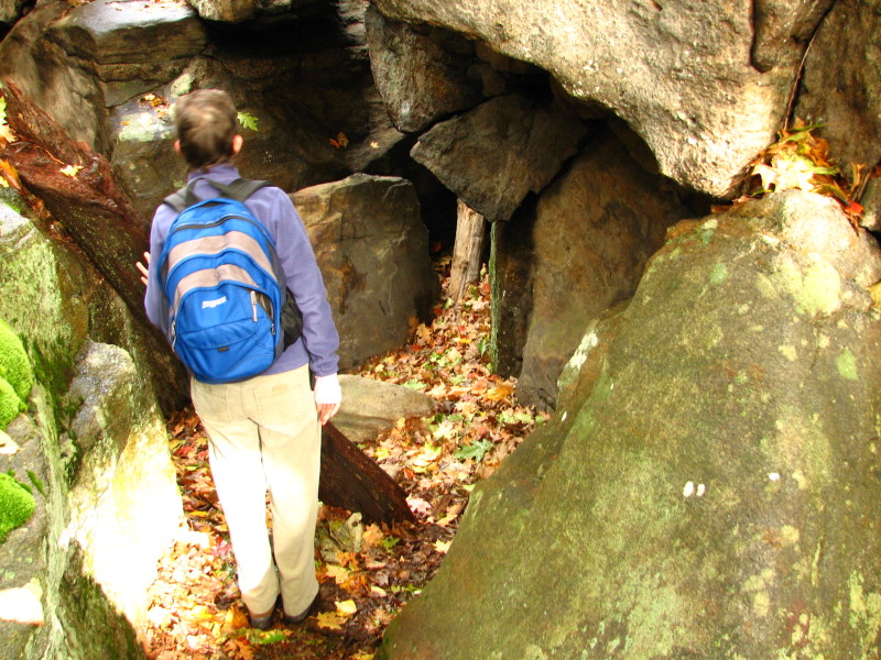
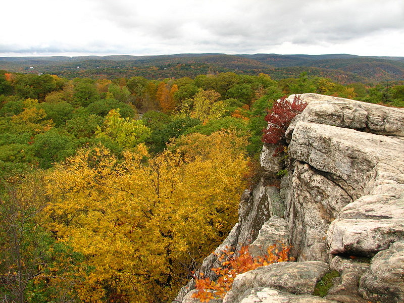
After meeting up with the gas line at milepost 1.35, the Blue Disc Trail continues on and ends crossing the same gas line again at milepost 1.5. The trail splits into two parts, one higher than the other, here and continue for .15 of a mile to Elbow Brush. Elbow Brush is a tight crevice made out of rocks. The trail continues on without any notable mentions until milepost 2, where it crosses the Tuxedo - Mt. Ivy Trail at the higher base of Claudius Smith Rock. Claudius Smith Rock is named after Claudius Smith, a convict who used the rock as a hideout from the law. He was hanged in Goshen in 1779. The next section of the Blue Disc Trail, continuing north, over the Big Pine Hill. The White Cross Trail, which starts 250 feet (76.2 m) away from the Blue Disc, is a safer route down the hill in the winter when the BD is icy. At the base of the hill, the Blue Disc Trail crosses a dam made of rocks and finally ends at Tri-Trail Corner, which is the meet of the Ramapo-Dunderberg Trail, Victory Trail and Blue Disc Trail. This point is 2.8 miles (4.5 km) away from the Johnsontown Road cul-de-sac.
. That route is now followed by the current-day Kakiat Trail and Blue Disc Trail. Hikers were brought to a mountain called Almost Perpendicular. From atop the mountain, the route followed a trail that reached Claudius Smith Rock with green cairns. Due to the green cairns, the trail was given the name Green Cairn Trail.
In Spring of 1932, a man named Paul H. Schubert (d. 1961) marked a trail with red discs that stretched from Sloatsburg, New York to Miss Julia Siedler's property on Johnsontown Road to Almost Perpendicular. Schubert had moved from Germany in 1891. A member of the NY-NJ Trail Conference, he had also blazed the Trail of Raccoon Hills. Almost Perpendicular and the land to the north were owned by the Tuxedo Park Association. At sporadic times, Miss Siedler and the TP Association closed their lands so that they wouldn't become public thoroughfares. In October 1943, the red metal disks on the Red Disc Trail and were replaced by blue ones supplied by Alexander Jassup.
The Blue Disc Trail used to start at the second corner of Johnsontown Road and Seven Lakes Drive, however it was moved to the cul-de-sac on Johnsontown Road, where parking exists.
Trail description
The Blue Disc Trail begins at a cul-de-sac on Johnsontown Road. The trail begins going up switchbacks to a pumping station for the Columbia Gas Transmission Corporation. The pipeline, which was created in 1949, crosses paths with the Blue Disc Trail later on the route. Beyond the pumping station, the Blue Disc Trail turns onto a woods road. However, before 1991, the Blue Disc Trail followed the gas line for another .15 of a mile to the Kakiat Trail After .3 of a mile on the woods road, the Blue Disc Trail joins up with the Kakiat Trail and soon splits again. The Blue Disc Trail continues for another .3 of a mile to the top of Almost Perpendicular, a name given by the Fresh Air Club in 1936. The trail continues on old, eroded road and crosses the gas line again at 1.35 miles (2.2 km).After meeting up with the gas line at milepost 1.35, the Blue Disc Trail continues on and ends crossing the same gas line again at milepost 1.5. The trail splits into two parts, one higher than the other, here and continue for .15 of a mile to Elbow Brush. Elbow Brush is a tight crevice made out of rocks. The trail continues on without any notable mentions until milepost 2, where it crosses the Tuxedo - Mt. Ivy Trail at the higher base of Claudius Smith Rock. Claudius Smith Rock is named after Claudius Smith, a convict who used the rock as a hideout from the law. He was hanged in Goshen in 1779. The next section of the Blue Disc Trail, continuing north, over the Big Pine Hill. The White Cross Trail, which starts 250 feet (76.2 m) away from the Blue Disc, is a safer route down the hill in the winter when the BD is icy. At the base of the hill, the Blue Disc Trail crosses a dam made of rocks and finally ends at Tri-Trail Corner, which is the meet of the Ramapo-Dunderberg Trail, Victory Trail and Blue Disc Trail. This point is 2.8 miles (4.5 km) away from the Johnsontown Road cul-de-sac.
History
In the early 20s and 30s, the Tuxedo Trail used to start from the town of Tuxedo and ended at Reeves Farm on Johnsontown RoadCounty Route 97 (Rockland County, New York)
County Route 97 is a long county highway in the western part of Rockland County, New York. CR 97 begins at the Sloatsburg village line, and ends at a dead end in Harriman State Park. CR 97 does not enter the village limits of any town in Rockland County, therefore it is designated in the Town of...
. That route is now followed by the current-day Kakiat Trail and Blue Disc Trail. Hikers were brought to a mountain called Almost Perpendicular. From atop the mountain, the route followed a trail that reached Claudius Smith Rock with green cairns. Due to the green cairns, the trail was given the name Green Cairn Trail.
In Spring of 1932, a man named Paul H. Schubert (d. 1961) marked a trail with red discs that stretched from Sloatsburg, New York to Miss Julia Siedler's property on Johnsontown Road to Almost Perpendicular. Schubert had moved from Germany in 1891. A member of the NY-NJ Trail Conference, he had also blazed the Trail of Raccoon Hills. Almost Perpendicular and the land to the north were owned by the Tuxedo Park Association. At sporadic times, Miss Siedler and the TP Association closed their lands so that they wouldn't become public thoroughfares. In October 1943, the red metal disks on the Red Disc Trail and were replaced by blue ones supplied by Alexander Jassup.
The Blue Disc Trail used to start at the second corner of Johnsontown Road and Seven Lakes Drive, however it was moved to the cul-de-sac on Johnsontown Road, where parking exists.
Major intersections
| Mile | Trail | Notes |
|---|---|---|
| 0.00 | Johnsontown Road (CR 97) | Southern terminus of the Blue Disc Trail. |
| 2.05 | Tuxedo-Mount Ivy Trail | Located at Claudius Smith Rock |
| 2.80 | Victory and Ramapo-Dunderberg Trails | Northern terminus of the Blue Disc Trail. |