

List of power stations in California
Encyclopedia

Power station
A power station is an industrial facility for the generation of electric energy....
s in California
California
California is a state located on the West Coast of the United States. It is by far the most populous U.S. state, and the third-largest by land area...
, sorted by type and name.
Nuclear power stations
| Plant | Location | Coords. | Notes |
|---|---|---|---|
| Diablo Canyon Power Plant Diablo Canyon Power Plant Diablo Canyon Power Plant is an electricity-generating nuclear power plant at Avila Beach in San Luis Obispo County, California. The plant has two Westinghouse-designed 4-loop pressurized-water nuclear reactors operated by Pacific Gas & Electric. The facility is located on about in Avila Beach,... |
San Luis Obispo County San Luis Obispo County, California San Luis Obispo County is a county located along the Pacific Ocean in the Central Coast of the U.S. state of California, between Los Angeles and the San Francisco Bay Area. As of the 2010 census its population was 269,637, up from 246,681 at the 2000 census... |
35°12′39.10"N 120°51′22.23"W | 2,240 MW |
| San Onofre Nuclear Generating Station San Onofre Nuclear Generating Station The San Onofre Nuclear Generating Station is a nuclear power plant located on the Pacific coast of California. The site is in the northwestern corner of San Diego County, south of San Clemente, and surrounded by the San Onofre State Park and next to the I-5 Highway.Unit 1 is no longer in service... |
San Diego County, California San Diego County, California San Diego County is a large county located in the southwestern corner of the US state of California. Hence, San Diego County is also located in the southwestern corner of the 48 contiguous United States. Its county seat and largest city is San Diego. Its population was about 2,813,835 in the 2000... |
33°22′8"N 117°33′18"W | 2,150 MW |
Gas-fired (or combined gas/coal)

| Plant | Location | Coords. | Notes |
|---|---|---|---|
| AES Alamitos LLC Gas Power Plant | Long Beach, California Long Beach, California Long Beach is a city situated in Los Angeles County in Southern California, on the Pacific coast of the United States. The city is the 36th-largest city in the nation and the seventh-largest in California. As of 2010, its population was 462,257... |
1,997 MW | |
| Gateway Generating Station | Antioch, California Antioch, California Antioch is a city in Contra Costa County, California. Located in the East Bay region of the San Francisco Bay Area along the San Joaquin-Sacramento River Delta, it is a suburb of San Francisco and Oakland. The city's population was 102,372 at the U.S... |
30 MWe | |
| Haynes Gas Power Plant | Long Beach, California Long Beach, California Long Beach is a city situated in Los Angeles County in Southern California, on the Pacific coast of the United States. The city is the 36th-largest city in the nation and the seventh-largest in California. As of 2010, its population was 462,257... |
1,581 MW | |
| Humboldt Bay Power Plant | Humboldt Bay, Calfironia | 105 MWe | |
| Moss Landing Power Plant Moss Landing Power Plant The Moss Landing Power Plant is a natural gas powered electricity generation plant located in Moss Landing, California, at the midpoint of Monterey Bay. The plant's large stacks are landmarks, visible throughout the Monterey Bay Area.-History:... |
Moss Landing, California Moss Landing, California Moss Landing is a census-designated place in Monterey County, California, United States. Moss Landing is located on the Pajaro Valley Consolidated Railroad north-northeast of Monterey, at an elevation of 10 feet . As of the 2010 census, the CDP population was 204, down from 300 at the 2000... |
36°48′17.54"N 121°46′55.19"W | 2,529 MW |
| Ormond Beach Gas Power Plant | Oxnard, California Oxnard, California Oxnard is the 113th largest city in the United States, 19th largest city in California and largest city in Ventura County, California, by way of population. It is located at the western edge of the fertile Oxnard Plain, and is an important agricultural center, with its distinction as the... |
1,516 MW | |
| Pittsburg Power Gas Power Plant | Pittsburg, California Pittsburg, California Pittsburg is a city located in eastern Contra Costa County, California, the outer portion of the East Bay region of the San Francisco Bay Area. The population was 63,264 at the 2010 census.... |
1,311 MW | |
| AES Redondo LLC Gas Power Plant | Redondo, California | 1,310 MW | |
| Huntington Beach Gas Power Plant | Huntington Beach, California Huntington Beach, California Huntington Beach is a seaside city in Orange County in Southern California. According to the 2010 census, the city population was 189,992; making it the largest beach city in Orange County in terms of population... |
888 MW |
Conventional
| Name | Location | Coordinates | Capacity |
|---|---|---|---|
| Shasta Dam Shasta Dam Shasta Dam is an arch dam across the Sacramento River in the northern part of the U.S. state of California, at the north end of the Sacramento Valley. The dam mainly serves long-term water storage and flood control in its reservoir, Shasta Lake, and also generates hydroelectric power... |
Redding Redding, California Redding is a city in far-Northern California. It is the county seat of Shasta County, California, USA. With a population of 89,861, according to the 2010 Census... |
40°43′07"N 122°25′08"W | 676 MW |
| Oroville Dam Oroville Dam Oroville Dam spans the Feather River about northeast of the city of Oroville, California. It forms Lake Oroville, which stores water for irrigation, flood control, municipal water supply and hydroelectricity generation in California's Sacramento Valley. The dam lies in the foothills of the Sierra... |
Oroville Oroville, California Oroville is the county seat of Butte County, California. The population was 15,506 at the 2010 census, up from 13,004 at the 2000 census... |
39°32′20"N 121°29′08"W | 645 MW |
| O'Shaughnessy Dam O'Shaughnessy Dam The O'Shaughnessy Dam is a curved gravity dam on the Tuolumne River in the Hetch Hetchy Valley of California's Sierra Nevada. The dam is located in Yosemite National Park, and creates the Hetch Hetchy Reservoir. It is named for former San Francisco chief engineer and the original chief engineer of... |
Yosemite National Park Yosemite National Park Yosemite National Park is a United States National Park spanning eastern portions of Tuolumne, Mariposa and Madera counties in east central California, United States. The park covers an area of and reaches across the western slopes of the Sierra Nevada mountain chain... |
37°56′51"N 119°47′17"W | 500 MW |
| New Bullards Bar Dam New Bullards Bar Dam New Bullards Bar Dam is a dam in California on the North Yuba River and forms the New Bullards Bar Reservoir, which has a capacity of . It is located near the town of Dobbins in Yuba County. The dam is operated by the Yuba County Water Agency for irrigation, drinking water and hydroelectric power... |
Dobbins Dobbins, California Dobbins is a census-designated place in Yuba County, California. It lies northeast of Marysville, at an elevation of 1742 feet, in the foothills of the western Sierra Nevada Mountain Range off of Highway 20 and Marysville Road. Dobbins is north of Oregon House and south of Bullards Bar Dam... |
39°23′36"N 121°08′35"W | 315 MW |
| New Melones Dam New Melones Dam New Melones Dam is an earth and rock filled dam across the Stanislaus River creating New Melones Lake. Situated between Calaveras and Tuolumne County, California in the Sierra Nevada foothills near Jamestown, the dam was completed in 1979 replacing the old Melones Dam.-Background:The dam was... |
Jamestown Jamestown, California Jamestown is a census-designated place in Tuolumne County, California, United States. The population was 3,433 at the 2010 census, up from 3,017 at the 2000 census.A scene from the movie Hidalgo was filmed in Jamestown... |
37°56′57"N 120°31′27"W | 300 MW |
| New Don Pedro Dam New Don Pedro Dam New Don Pedro Dam is built across the Tuolumne River and creates Lake Don Pedro in the foothills of the Sierra Nevada mountain range in the U.S. state of California. The New Don Pedro Dam takes its name from Don Pedros Bar which was named after Pierre "Don Pedro" Sainsevain... |
La Grange La Grange, California La Grange is a small unincorporated community in rural Stanislaus County, California, United States. Its altitude is 249 feet. As of 2008 it has a population of 345. , and it is located at .-History:... |
37°42′03"N 120°25′15"W | 203 MW |
| Folsom Dam Folsom Dam Folsom Dam is a concrete gravity dam on the American River in Northern California, about northeast of Sacramento. Folsom Dam is high concrete and long, flanked by earthen wing dams... |
El Dorado Hills El Dorado Hills, California El Dorado Hills is an unincorporated census-designated place located in El Dorado County, California, east of the state capital of Sacramento. The population was 42,108 at the 2010 census, up from 18,016 at the 2000 census... |
38°42′28"N 121°09′23"W | 199 MW |
| Mammoth Pool Dam | Sierra National Forest Sierra National Forest Sierra National Forest is a U.S. National Forest located on the western slope of central Sierra Nevada in the state of California. The forest is known for its mountain scenery and natural resources. Forest headquarters are located in Clovis, California... |
37°21′15"N 119°18′32"W | 190 MW |
| Spring Creek Powerplant* | Keswick Keswick, California Keswick is a census-designated place in Shasta County, California. Keswick sits at an elevation of . The 2010 United States census reported Keswick's population was 451.-Geography:... |
40°37′42"N 122°28′04"W | 180 MW |
| Pine Flat Dam Pine Flat Dam Pine Flat Dam is on the Kings River in the San Joaquin Valley, near Piedra in Fresno County, California, and forms Pine Flat Lake. It is a concrete gravity dam. The dam is owned and operated by the U.S. Army Corps of Engineers. Construction of the dam began in 1949 and was completed in 1954... |
Piedra Piedra, California Piedra is an unincorporated community in Fresno County, California. It is located on the south bank of the Kings River east of Fresno, at an elevation of 538 feet .... |
36°49′57"N 119°19′33"W | 165 MW |
| Judge Francis Carr Powerhouse* | Whiskeytown Whiskeytown, California Whiskeytown is an unincorporated community in Shasta County, California, United States. The ZIP Code is 96095. The community is inside area code 530. Although once a bustling mining town, there are very few people living in Whiskeytown as of today. The entire town of Whiskeytown was flooded to make... |
40°38′49"N 122°37′37"W | 154 MW |
| Trinity Dam Trinity Dam Trinity Dam is an earth dam on the Trinity River that forms Trinity Lake near Weaverville, California. Trinity Lake was previously called Clair Engle Lake. The earthfill dam was built by the U.S. Bureau of Reclamation. Construction was completed in 1962. Trinity Lake has a capacity of , making it... |
Weaverville Weaverville, California Weaverville is a census-designated place and the county seat of Trinity County, California. The population was 3,600 at the 2010 census, up from 3,554 at the 2000 census.-History:Founded in 1850, Weaverville is a historic California Gold Rush town... |
40°47′58"N 122°45′46"W | 140 MW |
| Parker Dam Parker Dam Parker Dam is a concrete arch-gravity dam that crosses the Colorado River downstream of Hoover Dam. Built between 1934 and 1938 by the Bureau of Reclamation, it is high, of which are below the riverbed, making it "the deepest dam in the world". The dam's primary functions are to create a... |
Bluewater Bluewater, California Bluewater is a census-designated place in San Bernardino County, California, United States. The population was 172 at the 2010 census, down from 265 at the 2000 census.-Geography:Bluewater is located at .... |
34°17′47"N 114°08′21"W | 120 MW |
| Keswick Dam Keswick Dam Keswick Dam is a concrete gravity dam on the Sacramento River about northwest of Redding, California. Part of the Bureau of Reclamation's Central Valley Project, the dam is high and impounds the Keswick Reservoir, which has a capacity of . Its power station has three turbines with a generating... |
Redding Redding, California Redding is a city in far-Northern California. It is the county seat of Shasta County, California, USA. With a population of 89,861, according to the 2010 Census... |
40°36′43"N 122°26′45"W | 117 MW |
| New Exchequer Dam New Exchequer Dam New Exchequer Dam is an earthfill dam on the Merced River in central California. It is mainly used by the Merced Irrigation District to provide irrigation water to several hundred square miles of the San Joaquin Valley surrounding the line of the Merced River.The dam was built to increase the... |
Merced Falls Merced Falls, California Merced Falls is an unincorporated community in Merced County, California. It is located on the north bank of the Merced River east of Snelling, at an elevation of 348 feet .A post office operated at Merced Falls from 1856 to 1957... |
37°39′32"N 120°15′14"W | 94.5 MW |
*Located along aqueduct or tunnel
Pumped-storage
| Name | Location | Coordinates | Capacity |
|---|---|---|---|
| Castaic Power Plant Castaic Power Plant Castaic Power Plant is a seven unit pumped-storage hydroelectric plant, operated by LADWP, which provides peak load power from the falling water on the West Branch of the California State Aqueduct... |
Angeles National Forest Angeles National Forest The Angeles National Forest of the U.S. National Forest Service is located in the San Gabriel Mountains of Los Angeles County, southern California. It was established on July 1, 1908, incorporating the first San Bernardino National Forest and parts of the former Santa Barbara and San Gabriel... |
34°35′15"N 118°39′24"W | 1,247 MW |
| Helms Power Plant | Fresno County Fresno County, California Fresno County is a county located in the Central Valley of the U.S. state of California, south of Stockton and north of Bakersfield. As of the 2010 census, it is the tenth most populous county in California with a population of 930,450, and the sixth largest in size with an area of . The county... |
37°02′21"N 118°57′49"W | 1,212 MW |
| San Luis Dam San Luis Dam San Luis Dam is a dam that creates San Luis Reservoir, which serves as an off-stream reservoir for the California State Water Project and the Central Valley Project. It is also known as the B.F. Sisk Dam, after Bernie Sisk. The earth-fill gravity embankment dam is 305 feet tall and was completed... |
Los Banos Los Banos, California Los Banos is a city in Merced County, California, near the junction of State Route 152 and Interstate 5. Los Banos is located southwest of Merced, at an elevation of 118 feet . The population was 35,972 at the 2010 census, up from 25,869 at the 2000 census... |
37°04′07"N 121°04′48"W | 424 MW |
Wind Power
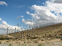
| Name | Location | Coordinates | Capacity |
|---|---|---|---|
| Alta Wind Energy Center Alta Wind Energy Center The Alta Wind Energy Center is a wind farm located in Tehachapi Pass of the Tehachapi Mountains, in Kern County, California. As of 2011, it is the largest wind farm in California, with a combined installed capacity of 720 MW. The project, which is being developed near Tehachapi Pass Wind Farm... * |
Kern County Kern County, California Spreading across the southern end of the California Central Valley, Kern County is the fifth-largest county by population in California. Its economy is heavily linked to agriculture and to petroleum extraction, and there is a strong aviation and space presence. Politically, it has generally... |
35°00′00"N 118°18′00"W | 800 MW |
| Tehachapi Pass Wind Farm Tehachapi Pass Wind Farm Wind development in the Tehachapi Pass began in the early 1980s. The area hosts a multitude of wind farms, comprising one of California's largest wind resource areas. The pass is undergoing much repowering activity... |
Tehachapi Mountains Tehachapi Mountains The Tehachapi Mountains , regionally also called The Tehachapis, are a mountain range in the Transverse Ranges system of California in the Western United States... |
35°06′08"N 118°16′58"W | 705 MW |
| San Gorgonio Pass Wind Farm San Gorgonio Pass Wind Farm The San Gorgonio Pass Wind Farm is a wind farm located on the eastern slope of the San Gorgonio Pass in Riverside County, just east of White Water, California, United States. Developed beginning in the 1980s, it is one of three major wind farms in California, along with those at Altamont and the... |
White Water White Water, California Whitewater is a census-designated place in Riverside County, California. It is directly off Interstate 10 halfway between North Palm Springs and Cabazon on the way from Palm Springs to Los Angeles. It is known as the site of the San Gorgonio Pass Wind Farm. The ZIP Code is 92282, and the... |
33°54′54"N 116°35′18"W | 615 MW |
| Altamont Pass Wind Farm Altamont Pass Wind Farm The Altamont Pass Wind Farm is located in the Altamont Pass of the Diablo Range in Central California. It is one of the earliest wind farms in the United States. The wind farm is composed of 4930 relatively small wind turbines of various types, making it at one time the largest farm in the world in... |
Livermore Livermore, California Livermore is a city in Alameda County. The population as of 2010 was 80,968. Livermore is located on the eastern edge of California's San Francisco Bay Area.... |
37°43′57"N 121°39′09"W | 576 MW |
| Shiloh Wind Power Plant Shiloh Wind Power Plant The Shiloh Wind Power Plant is a wind farm located in the Montezuma Hills of Solano County, California, USA, very near to Bird's Landing. It has a nameplate capacity of 300 megawatts of power and was built in two stages.- Shiloh I :... |
Bird's Landing | 38°07′00"N 121°50′30"W | 300 MW |
*Under construction
Photovoltaic
List of current solar photovoltaic power stations in California.| Station | Location | Coordinates | Capacity (MW) | Status | Notes |
|---|---|---|---|---|---|
| Topaz Solar Farm Topaz Solar Farm Topaz Solar Farm is a proposed 550 megawatt solar photovoltaic power plant, to be built by First Solar, Inc. in the Carrizo Plain, northwest of California Valley at a cost of over $1 billion... |
35°23′N 120°4′W | 550 | Under construction | ||
| California Valley Solar Ranch California Valley Solar Ranch The California Valley Solar Ranch is a 250 megawatt solar photovoltaic power plant, which is being built by SunPower in the Carrizo Plain, northeast of California Valley. Construction on the project began in September 2011, with approximately 350 jobs expected to be created in San Luis... |
Carrizo Plain Carrizo Plain The Carrizo Plain is a large enclosed plain, approximately 50 miles long and up to 15 miles across, in southeastern San Luis Obispo County, California, about 100 miles northwest of Los Angeles, California... |
35°20′N 119°55′W | 250 | Under construction | |
| AV Solar Ranch One | Mojave Desert Mojave Desert The Mojave Desert occupies a significant portion of southeastern California and smaller parts of central California, southern Nevada, southwestern Utah and northwestern Arizona, in the United States... |
230 | Under construction |
Thermal
List of current solar thermal power stations in California.| Station | Location | Coordinates | Capacity (MW) | Status | Notes |
|---|---|---|---|---|---|
| Solar Energy Generating Systems Solar Energy Generating Systems Solar Energy Generating Systems is the largest solar energy generating facility in the world. It consists of nine solar power plants in California's Mojave Desert, where insolation is among the best available in the United States... |
Mojave Desert Mojave Desert The Mojave Desert occupies a significant portion of southeastern California and smaller parts of central California, southern Nevada, southwestern Utah and northwestern Arizona, in the United States... |
35°01′54"N 117°20′53"W | 354 | Operational | |
| Kimberlina Solar Thermal Energy Plant Kimberlina Solar Thermal Energy Plant The 5 megawatt Kimberlina Solar Thermal Energy Plant in Bakersfield, California is the first commercial solar thermal power plant to be built by AREVA Solar, formerly Ausra. The Kimberlina renewable energy solar boiler uses Compact Linear Fresnel Reflector technology to generate superheated steam... |
Bakersfield, California Bakersfield, California Bakersfield is a city near the southern end of the San Joaquin Valley in Kern County, California. It is roughly equidistant between Fresno and Los Angeles, to the north and south respectively.... |
5 | Operational | ||
| Sierra SunTower Sierra SunTower Sierra SunTower is a 5 MW commercial concentrating solar power plant built and operated by eSolar. The plant is located in Lancaster, California and is the only CSP tower facility operating in North America.- Project overview :... |
Lancaster, California Lancaster, California Lancaster is a charter city in northern Los Angeles County, in the high desert, near the Kern County line. Lancaster currently ranks as the 30th largest city in California, and the 148th largest city in the United States. Lancaster is the principal city within the Antelope Valley... |
34°46′0.0"N 118°8′0.0"W | 5 | Operational |