

List of menhirs
Encyclopedia
Megalith
A megalith is a large stone that has been used to construct a structure or monument, either alone or together with other stones. Megalithic describes structures made of such large stones, utilizing an interlocking system without the use of mortar or cement.The word 'megalith' comes from the Ancient...
s.
Bulgaria
- Ovcharovo, Haskovo ProvinceOvcharovo, Haskovo ProvinceOvcharovo, Haskovo Province is a village in the municipality of Harmanli, in Haskovo Province, in southern Bulgaria....
in SakarSakarSakar is a mountain in southeastern Bulgaria, between the rivers Maritsa, Tundzha, Sokolitsa and Sazliyka and close to the borders with Greece and Turkey. The mountain's highest peak is Vishegrad at 856 m.... - Pobit Kamak, Pazardzhik Province in the Rhodopes
Czech Republic
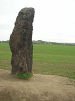
- Dolní Chabry
- Drahomyšl
- Družec
- Horoměřice
- Jemníky
- Kersko
- KlobukyKlobukyKlobuky is a village in Central Bohemian Region of the Czech Republic. It is located in an agricultural landscape about 10 km northwest of Slaný or 39 km northwest of Prague and has a population of 1,030...
, Central BohemiaBohemiaBohemia is a historical region in central Europe, occupying the western two-thirds of the traditional Czech Lands. It is located in the contemporary Czech Republic with its capital in Prague...
, some 25 km NW of Prague - GPS: N50°18'4.49", E13°59'4.23". Known as Kamenný pastýř (Stone shepherd), it is the tallest of Czech menhirs, over 3 m (10 ft) tall. - Klůček
- Ledce
- Louny (Selibice)
- Libenice
- Orasice
- Slaný
- Slavětín
- Tuchlovice
- Vinařice
- Žatec (Březno)
France
- Carnac stonesCarnac stonesThe Carnac stones are an exceptionally dense collection of megalithic sites around the French village of Carnac, in Brittany, consisting of alignments, dolmens, tumuli and single menhirs. The more than 3,000 prehistoric standing stones were hewn from local rock and erected by the pre-Celtic people...
, BrittanyBrittanyBrittany is a cultural and administrative region in the north-west of France. Previously a kingdom and then a duchy, Brittany was united to the Kingdom of France in 1532 as a province. Brittany has also been referred to as Less, Lesser or Little Britain... - FilitosaFilitosaFilitosa is a megalithic site in southern Corsica, France. The period of occupation spans from the end of the Neolithic era and the beginning of the Bronze Age, until around the Roman times in Corsica.-Location:...
, CorsicaCorsicaCorsica is an island in the Mediterranean Sea. It is located west of Italy, southeast of the French mainland, and north of the island of Sardinia.... - Saint-Sulpice-de-FaleyrensSaint-Sulpice-de-FaleyrensSaint-Sulpice-de-Faleyrens is a commune in the Gironde department in Aquitaine in southwestern France.It is one of eight municipalities forming the jurisdiction of Saint-Emilion, which is a UNESCO World Heritage of Humanity for its historic vineyard landscape that has survived intact and in...
, GirondeGirondeFor the Revolutionary party, see Girondists.Gironde is a common name for the Gironde estuary, where the mouths of the Garonne and Dordogne rivers merge, and for a department in the Aquitaine region situated in southwest France.-History:... - Cham des Bondons, LozèreLozèreLozère , is a department in southeast France near the Massif Central, named after Mont Lozère.- History :Lozère is one of the original 83 departments created during the French Revolution on March 4, 1790...
- Peyre Quillade stones, AriegeAriègeAriège is a department in southwestern France named after the Ariège River.- History :Ariège is one of the original 83 departments created during the French Revolution on 4 March 1790. It was created from the counties of Foix and Couserans....
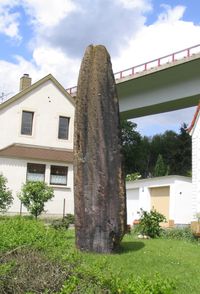
Germany
- Gollenstein, Blieskastel (6.6 m high)
- Spellenstein, St. Ingbert (5 m high)
- Mittelbrunn, Rhineland-Palz
Ireland
- ArdgroomArdgroomArdgroom is a village on the Beara peninsula in County Cork, Ireland. Its name refers to two gravelly hills deposited by a glacier, Dromárd and Drombeg. It lies to the northwest of Glenbeg Lough, overlooking the Kenmare River estuary. It sits between the coast and the Slieve Miskish Mountains. The...
- BeenalaghtBeenalaghtBeenalaght is an alignment of six standing stones located on a flat pasture in Reanthesure, 0.5km west of the village of Bweeng, County Cork, Ireland. It is 13.6km south-west of Mallow, on a hill to the west of the Mallow-Coachford Road...
- BohonaghBohonaghBohonagh is a recumbent stone circle located 2.4 km east of Rosscarbery, County Cork, Ireland. The circle is thought to date from the Bronze Age. A boulder burial is sited nearby .-Features:...
- DrombegDrombeg stone circleDrombeg stone circle , is a Recumbent stone circle located east of Glandore, County Cork, Ireland. Drombeg is one of the most visited megalithic sites in Ireland...
- EightercuaEightercuaEightercua is a four-stone alignment Megalithic tomb, located 1.5 km south-south-east of Waterville, County Kerry, Ireland. The tallest stone reaches 9 feet in height, and the alignment streaches for twenty five feet in an east-west direction...
- Glantane eastGlantane eastGlantane East is a megalithic complex situated from Millstreet, County Cork, Ireland. It is set in the Keel River valley on the north-west upper slopes of Musherabeg mountain, in the townland of Glantane...
- KnocknakillaKnocknakillaKnocknakilla megalithic complex lies between Macroom and Millstreet, in County Cork, Ireland. It is set in blanket peatland on the north-west upper slopes of Musherabeg mountain, and is said to be 3500 years old...
- ReaskReaskReask is a ruined early Monastic site located 1 km east of Baile an Fheirtéaraigh, County Kerry, Ireland. Although nothing remains of the buildings but low walls and a cross-slab standing stone which sits in the middle of the compound, this site gives a very good idea of the layout of a...
Italy
- Menhirs Valley - ozieriOzieriOzieri is a town and comune of approximatively 11,000 inhabitants in the province of Sassari, northern Sardinia , in the Logudoro historical region...
, SardiniaSardiniaSardinia is the second-largest island in the Mediterranean Sea . It is an autonomous region of Italy, and the nearest land masses are the French island of Corsica, the Italian Peninsula, Sicily, Tunisia and the Spanish Balearic Islands.The name Sardinia is from the pre-Roman noun *sard[],... - GoniGoniGoni is a town and comune in the province of Cagliari, Sardinia, Italy...
- SardiniaSardiniaSardinia is the second-largest island in the Mediterranean Sea . It is an autonomous region of Italy, and the nearest land masses are the French island of Corsica, the Italian Peninsula, Sicily, Tunisia and the Spanish Balearic Islands.The name Sardinia is from the pre-Roman noun *sard[],... - LugnaccoLugnaccoLugnacco is a comune in the Province of Turin in the Italian region Piedmont, located about 45 km north of Turin. As of 31 December 2004, it had a population of 378 and an area of 4.8 km²....
North West Italy.
Malta
- Kercem - Gozo Dawwara standing stone.
- KirkopKirkopĦal Kirkop is a small village in the south of Malta. It is found near the Malta International Airport and this settlement has a rich history, that of even Punic times. The parish church is dedicated to St. Leonard. Apart from the feast of St. Leonard, a secondary big feast of St. Joseph is...
- Qala - Gozo
- Wied Ghomar - Rabat
- XemxijaXemxijaXemxija is a resort area on the west side of St. Paul's Bay, Malta.Xemxija is the gateway to the sandy beaches of Golden Bay to the west, and to Mellieha Bay to the north. Xemxija is a quiet resort, surrounded by Maltese countryside and some of the most fertile valleys in Malta. There is also a...