

List of islands of the Philippines
Encyclopedia
Island
An island or isle is any piece of sub-continental land that is surrounded by water. Very small islands such as emergent land features on atolls can be called islets, cays or keys. An island in a river or lake may be called an eyot , or holm...
s of the Philippines
Philippines
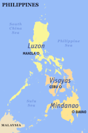
The Philippines , officially known as the Republic of the Philippines , is a country in Southeast Asia in the western Pacific Ocean. To its north across the Luzon Strait lies Taiwan. West across the South China Sea sits Vietnam...
. There are 7,107 islands, of which about 4,000 are inhabited. They are clustered into the island groups of Luzon
Luzon
Luzon is the largest island in the Philippines. It is located in the northernmost region of the archipelago, and is also the name for one of the three primary island groups in the country centered on the Island of Luzon...
, Visayas
Visayas
The Visayas or Visayan Islands and locally known as Kabisay-an gid, is one of the three principal geographical divisions of the Philippines, along with Mindanao and Luzon. It consists of several islands, primarily surrounding the Visayan Sea, although the Visayas are considered the northeast...
, and Mindanao
Mindanao
Mindanao is the second largest and easternmost island in the Philippines. It is also the name of one of the three island groups in the country, which consists of the island of Mindanao and smaller surrounding islands. The other two are Luzon and the Visayas. The island of Mindanao is called The...
.
Luzon
-
- Aguta Island
- Alabat IslandAlabat IslandAlabat Island is an island of the Philippine archipelago, in the Quezon Province of the CALABARZON region, situated just off the East coast of Southern Luzon...
- Alava Island
- Albaguan Island
- Albay gulf Island
- Ambil Island
- Anawangin
- Babuyan IslandsBabuyan IslandsThe Babuyan Islands form an archipelago located in the Luzon Strait north of Luzon island in the Philippines. It is separated from Luzon by the Babuyan Channel and from the Batanes Islands to its north by the Balintang Channel....
- Bagambangan Island
- Bagatao Island
- Balabac IslandBalabac IslandBalabac Island is the southern-most island of the Palawan province in the Philippines, only about north from Sabah, Malaysia, across the Balabac Strait.Administratively, the island forms the main part of Balabac Municipality and is divided into 14 barangays:...
- Balesin Island
- Balintang Island
- Bancalan Island
- Banton IslandBanton IslandBanton Island is an island in the province of Romblon in the Philippines. It has one municipality named Banton.It is the most northerly island of the province; the surface is rugged except in the southeast; the soil is sterile and few crops are raised; the chief industry is the mining of gypsum....
- Barangonan Island
- Barit Island
- Batan IslandBatan IslandBatan island is the main island of the Batanes Province in the Philippines, part of the Batanes Islands group and the Luzon Volcanic Arc. It is home to the provincial capital Basco. The island is known chiefly for Mount Iraya....
- Batanes Islands
- Batas Island
- Beni Island
- Binalabag Island
- Binatican Island
- Bisucay Island
- Bay Bay
- Boayan Island
- Boliungan(Luzon) Island
- Bugsuk IslandBugsuk Island- History :Eight crewmembers of the USS Flier reached Bugsuk Island after their submarine struck a mine on Aug. 13, 1944 while on surface patrol during World War II. The survivors, who had been on deck and in the conning tower when the explosion occurred, swam 18 hours to reach an atoll near Bugsuk...
- Burias IslandBurias IslandBurias Island is one of the three major islands of Masbate Province in the Philippines. The other two major Islands are Ticao Island and Masbate Island. The Island has two municipalities, Claveria and San Pascual....
- Busuanga IslandBusuanga IslandBusuanga Island is the largest island in the Calamian Group in the province of Palawan in the Philippines. Busuanga Island is, in fact, the second largest island in the province after Palawan island itself. The island is located halfway between the islands of Mindoro and Palawan with the South...
- Butauanan Island
- Caban Island
- Cabarruyan Island
- Cabra Island
- Cabuli Island
- Cacnipa Island
- Cadaraman Island
- Cadlao Island
- Calabadian Island
- Calabugdong Island
- Calamian GroupCalamian GroupThe Calamian is a group of islands in the Philippine province of Palawan. It includes:* Busuanga Island* Coron Island* Culion Island* Calauit Island* several minor islands....
- Calayan IslandCalayan, CagayanCalayan is a 3rd class municipality in the province of Cagayan, Philippines. According to the latest census, it has a population of 16,233 people in 2,654 households....
- Calibang IslandCalibang IslandCalibang Island located west of Linapacan in the Province of northern Palawan is a Tagbanwa Tribal Sanctuary consisting of less than a thousand native inhabitance....
- Calintaan Island
- Camiguin Island
- Canabungan Island
- Capones Island
- Carlota IslandCarlota IslandCarlota Island is an inhabited island in the province of Romblon in the Philippines. It is part of barangay Nasunogan in the municipality of Banton. In the 1918 census, the island together with its sister island Isabel Island constituted one single barrio named "Isla de los Hermanos" with 23...
- Carnasa Island
- Casian Island
- Catalat Island
- CatanduanesCatanduanesCatanduanes is an island province of the Philippines located in the Bicol Region in Luzon. Its capital is Virac and the province lies to the east of Camarines Sur across Maqueda Channel. As of 2007, the population of the province is 232,757 people.-Etymology:"Isla de Cobos" was Catanduanes' first...
- Cauayan Island
- Chindonan Island
- Coron IslandCoron IslandCoron Island is the third largest island in the Calamian Group of Islands in northern Palawan in the Philippines. The island is part of the larger municipality of the same name. It is about southwest of Manila, is known for several Japanese shipwrecks World War II vintage. The island is part of...
- Corregidor Island
- Culion Island
- Cuyo Island
- Dalahican Island
- Dalupiri Island (Babuyan Islands)
- Darocotan Island
- Dequey IslandDequeyDequey is one of the Batanes Islands, in the province of Batanes, in Luzon Strait, the Philippines. The island is a very small and a rather low piece of land, lying nearly 1/2 mile westward of the northwest point of Ivuhos Island...
- Destacado Island
- Diadekey Island
- Dicabaito Island
- Dimipac Island
- Diogo IslandDiogo IslandDiogo Island is an uninhabited volcanic island in the province of Batanes, the northernmost province in the Philippines. Also known as Dinem Island in the native language, Diogo is a lone rock rising out of the sea, with steep cliffs on every side, and dangerous currents make landing there...
- Ditarem Island
- Dumaran Island
- El Fraile Island
- Flat IslandFlat IslandFlat Island or Ngan Chau is an island of between Heung Leung Kok and Ocean Point in the north shore of Sai Kung Peninsula of Hong Kong.It is at the mouth of in Hoi Ha Wan and the boundary of Hoi Ha Wan Marine Park ....
- Fuga IslandFuga IslandFuga Island is an island in the municipality of Aparri, Cagayan, with an area of 100 km². Together with its nearshore western neighbor islets Barit and Mabag it constitutes one of 42 barangays of the city of Aparri. It is located in the northernmost part of the Philippines as part of the...
- Gabung Island
- Galoc Island
- Guintinua IslandGuintinua IslandGuintinua Island is one of the two major islands in the Calaguas Group of Islands in Vinzons, Camarines Norte, Philippines. Barangay Banocboc, Vinzons, Camarines Norte is located on the island...
- Guntao Island
- Hermana mayor Island
- Hermana menor Island
- Hundred Islands
- Ibuhos Island
- Icadambanauan Island
- Igbon IslandIgbon IslandIgbon Island, or just Igbon, is part of the Visayas island chain, Iloilo Province, Philippines. Throughout the 20th century and in the early 21st century the Moranos, Basas and Villarias have been the chief families of Igbon....
- Iloc Island
- Imuruan Island
- Inampulugan Island
- Inatula Island
- Itbayat IslandItbayat IslandItbayat is one of the Batanes Islands of the Philippines. Together with some other islands it forms the municipality of Itbayat in Batanes Province....
- Itu Aba Island
- Ivuhos Island
- Jomalig IslandJomalig, QuezonJomalig is a 6th class municipality in the province of Quezon, Philippines. According to the 2007 census, it has a population of 6,111..-Barangays:Jomalig is politically subdivided into 5 barangays.*Bukal*Casuguran*Gango*Talisoy *Apad-History:...
- Kalayaan Group of Islands or Spratly Islands (claimed by Malaysia,Taiwan,China,Indonesia,Brunai and Vietnam)
- Kalongkooan Island
- Lagen Island
- Lalutaya Island
- Lamud Island
- Latuan Island
- Linapacan Island
- Looc bay Island
- Lubang IslandLubang IslandLubang Island is the largest island in the Lubang Group of Islands, an archipelago which lies to the northwest of the northern end of Mindoro in the Philippines. The Lubang Islands are about southwest of Manila. There are seven islands in the group, The island is divided into two municipalities. ...
- Lumbucan Island
- LuzonLuzonLuzon is the largest island in the Philippines. It is located in the northernmost region of the archipelago, and is also the name for one of the three primary island groups in the country centered on the Island of Luzon...
- Mabaag Island
- Mabudis Island
- Macaranao Island
- Maculabo IslandMaculabo IslandMaculabo Island is an island which belongs to the Calaguas group of islands in Camarines Norte province. Although part of the Calaguas group, the island is under the jurisdiction of the municipality of Paracale, Camarines Norte. The island serves as a major stop-over going to Tinaga Island where...
- Malanao Island
- Manamoc Island
- Mantangule Secam Island
- Maricaban Island
- MarinduqueMarinduqueIn 1945, combined American and Philippine Commonwealth troops attacked from the Japanese Troops liberated to the Battle of Marinduque in the Second World War.-Archaeology:...
- Masbate IslandMasbate IslandMasbate is one of the three major islands of Masbate Province in the Philippines. The other two major Islands are Ticao Island and Burias Island. It is the world's 155th largest island according to area and the world's 59th largest island according to population.Masbate Related Website...
- Matabao Island
- Matarbis Island
- Matinloc Island
- Mauban Island
- Mavudis IslandMavudis IslandMavudis Island is the northernmost of the Batanes Islands and the northernmost island in the Philippines. It is part of the province of Batanes...
- Maytiguid Island
- Mindoro Island
- Namyit IslandNamyit IslandNamyit Island or Nam Yet Island is one of the islands of Spratly Islands in South China Sea. With an area of 5.3 hectares, it is the twelfth largest Spratly island and the fifth largest among the Vietnamese-occupied Spratly islands. It is covered with small trees, bushes and grass, has a fringing...
- Nanshan IslandNanshan IslandNanshan Island is the eighth largest island of Spratly Islands and the fourth largest among Philippine-occupied Spratly islands. It has an area of 7.93 hectares. It is located 98.0 miles east of Pag-asa . This island is administered by the Philippines as part of Kalayaan,...
- Naranjo Island
- Oco Island
- Orchid IslandOrchid IslandOrchid Island is a 45-km² volcanic island off the southeastern coast of Taiwan island and separated from the Batanes of the Philippines by the Bashi Channel of the Luzon Strait. It is governed as Lanyu Township of Taitung County...
(Administered by Republic of China,{Taiwan}claimed by the PhilippinesTerritories claimed by the PhilippinesThe Republic of the Philippines had claimed many lands throughout its history. These include the Spratly Islands, Sabah, Scarborough Shoal, Benham Plateau, Palmas or Miangas Island, the Sangir Islands, Orchid Island, Marianas Islands and Caroline Islands....
) - Palasan Island
- Palaui IslandPalaui IslandPalaui Island is one of the islands in the Philippines, located off the northeastern extremity of Luzon Island, the largest island in the country.-Geography:...
- Palawan Group
- Palawan IslandPalawan IslandPalawan Island is the largest island of the Palawan Province, Philippines. The northern coast of the island is along the South China Sea, while the southern coast forms part of the northern limit of the Sulu Sea. This island is very undeveloped and traditional...
- Paly Island
- Pamalican Island
- Pandanan Island
- Panuitan Island
- Patnanongan IslandPatnanongan IslandPatnanongan Island is one of the Polillo Islands in Quezon province, Philippines. It has an area of 92 km2....
- Polillo IslandPolillo IslandPolillo is an island in the Northeastern region of the Philippine archipelago. It is separated from the island of Luzon by the Polillo Strait.The island itself is subdivided across three municipalities. The municipality of Polillo takes up the Southern part of the island...
- Polillo Islands
- Potipot Island
- Pucoy Island
- Ramos IslandRamos IslandRamos Island is an island in the Solomon Islands; it is located in Isabel Province....
- Rapu-rapu IslandRapu-rapu IslandRapu-rapu Island is an island in the Philippines where the municipality of Rapu-rapu, Albay is located. It is situated in the Lagonoy Gulf.It is one of the two islands comprising the whole municipality. The other island is Batan Island....
- Rasa Island
- Refugio Island
- Romblon IslandRomblon IslandRomblon is one of the three major islands of the Romblon Province in the Philippines; the other two are Sibuyan Island and Tablas Island. The island is part of the seat of government for the Romblon province, also named Romblon municipality....
- Sabtang IslandSabtang IslandSabtang is an inactive volcanic island, one of the Batanes Islands of the Philippines. Together with some other islands it forms the municipality of Sabtang in Batanes Province.-External links:*...
- San Andres Island
- Santiago Island
- Siayan IslandSiayan IslandSiayan is one of the Batanes Islands of the Philippines. Also known as Ditarem Island in the native language, the island is about 1/2 mile to 3/4 miles in diameter and lies about 5 miles north-northeastward of Itbayat Island. The closest island is Mabudis Island which is about 1 miles...
- Sibale Island
- Sibuyan IslandSibuyan IslandSibuyan is a crescent-shaped island of Romblon Province, Philippines. It has an area of 445 km². The island has two prominent peaks, Mount Guiting-Guiting with a height of 2,058 m and Mount Nailog with a height of 789 m...
- Sin Cowe IslandSin Cowe IslandSin Cowe Island or Sinh Ton Island is an island in the Spratly Islands in the South China Sea. With an area of 8 hectares, it is the seventh largest Spratly island and the third largest among Vietnamese-occupied Spratly islands. It has fringing reef which is above water at low tide...
- Soguicay Island
- Spratly IslandsSpratly IslandsThe Spratly Islands are a group of more than 750 reefs, islets, atolls, cays and islands in the South China Sea. The archipelago lies off the coasts of the Philippines and Malaysia , about one third of the way from there to southern Vietnam. They comprise less than four square kilometers of land...
- Stanlake Island
- Tablas IslandTablas IslandTablas is the largest of the islands that comprise the province of Romblon in the Philippines.Odiongan, on the west central coast of the island, is a major port and the largest municipality of Romblon in terms of population...
- Tagalinog Island
- Tambon Island
- Tampel Island
- Tandubas Island
- Tapiutan Island
- Thitu IslandThitu IslandThitu Island , having an area of 37.2 hectares is the second largest Spratly Island and the largest of all Philippine-occupied Spratly Islands. It lies about west of Puerto Princesa City...
- Ticao IslandTicao IslandTicao Island is one of the three major islands of Masbate Province in the Philippines. The other two major Islands are Masbate Island and Burias Island ....
- Tinaga IslandTinaga IslandTinaga Island is an island located in Vinzons, Camarines Norte, Philippines. It is one of the two major islands in the Calaguas Group of Islands, about eight kilometers long. Tinaga island is famous for its long white sand beach called "Mahabang Buhangin", which literally means "long beach"...
- Tingtingong Island
- Tubbataha ReefTubbataha ReefTubbataha Reef is an atoll coral reef located in the Sulu Sea of the Philippines. It is a marine sanctuary protected as Tubbataha Reef National Marine Park...
- Tulutan Island
- Verde IslandVerde IslandThis article refers to an island, for the body of water see Verde Island Passage.Verde Island is situated along the bodies of Verde Island Passage between the islands of Luzon and Mindoro, Philippines. It was on 1988 when a small village was created through the effort of an European project using...
- Volcano Island
- West Nalaut IslandWest Nalaut IslandWest Nalaut Island is an island in northern Palawan, in the Philippines. It is the westernmost of the Calamian Islands, and can form a guide to shipping entering the Coron West Passage. It is approximately 16 km off the western coast of Busuanga Island, which is approximately a 40 minute...
- West York IslandWest York IslandWest York Island or Likas Island , having an area of 18.6 hectares, is the third largest island of the Spratly Islands chain in South China Sea. It is the second largest island among Philippine-occupied Spratly islands. It is wide at its widest part; and in length...
Visayas
-
- Abad Island
- Almagro Island
- Ambulong Island
- Andis Island
- Apo IslandApo IslandApo Island is a volcanic island covering 12 hectares in land area, 7 kilometers off the southeastern tip of Negros Island and 30 kilometers south of the Negros Oriental capital of Dumaguete City in the Philippines....
- Baasan Island
- Balicasag Island
- Banacon Island
- Banbanon Island
- Bantayan IslandBantayan IslandBantayan Island is in the Visayan Sea, Philippines, located just west off the northern tip of Cebu Island. The island, politically a part of the Province of Cebu, is about wide by long, with a total population of 120,101, as of the 2000 census. It is also the main and largest island of the...
- Batbatan Island
- Batquis Island
- Biliran IslandBiliran IslandBiliran is a volcanic island in the central Philippines. It is one of the active volcanoes in the Philippines.*Classification: Active*Current Summit Activities: Solfataric*Province: Biliran Region VIII*Nearby Cities/Towns:...
- Binuluangan Island
- Bohol IslandBohol IslandBohol Island is the main island of Bohol Province in the Visayas. It lies southeast from Cebu Island across Cebu Strait and southwest from Leyte Island, separated by the Camotes Sea and Canigao Channel...
- BoracayBoracayBoracay is an island of the Philippines located approximately south of Manila and 2 km off the northwest tip of Panay Island in the Western Visayas region of the Philippines. Boracay Island and its beaches have received awards numerous times. Boracay was awarded in the "Travelers' Choice...
- Buad Island
- Bulalacao Island
- Bulusan Island
- Cabilao Island
- Cabilo Island
- Cabulauan Island
- Cagayan Island
- Calagnaan Island
- Calagnaan Island
- Calicoan IslandCalicoan IslandCalicoan Island is a Philippine island, and is part of the town of Guiuan, in the province of Eastern Samar. It lies east of Leyte Gulf, off the southeast point of Samar.The island can be reached from Tacloban City by a two-hour bus ride.-External links:*...
- Camandag Island
- Camotes Island
- Canigao Island
- Capiñahan Island
- Capul Island
- Carabao IslandCarabao IslandCarabao Island can refer to two islands in the Philippines:* Carabao Island, the former name of San Jose, the southernmost island in the province of Romblon* Carabao Island, an island in the province of Cavite...
- Cebu IslandCebu IslandCebu is an island of the Philippines. It is the main island of Cebu Province at the center of the Visayan Islands, south of Manila.It lies to the east of Negros Island; to the east is Leyte and to the southeast is Bohol Island. It is flanked on both sides by the Cebu Strait and Tañon Strait...
- Cobrador Island
- Cordova Island
- Crocodile Island
- Dalupiri Island (Northern Samar)San Antonio, Northern SamarSan Antonio is a 5th class municipality in the province of Northern Samar, Philippines. According to the 2007 census, it has a population of 8,151 people.-History:San Antonio was established in 1904...
- Doong Island
- Dalutan Island
- Ginuruan Island
- GuimarasGuimarasGuimaras is an island province of the Philippines located in the Western Visayas region. Among the smallest provinces, its capital is Jordan. The island is located in the Panay Gulf, between the islands of Panay and Negros...
- Guiwanon Island
- Gunauayan Island
- Handayan Island
- Higatangan Island
- Homonhon IslandHomonhon IslandHomonhon Island is an island in the province of Eastern Samar, Philippines, on the east side of Leyte Gulf. It is about 20 km long.-History:...
- Hurao Hurao Island
- Iloilo Island
- InampuluganInampuluganInampulugan is an island in the Philippines. It is part of Guimaras Province. The mountainous island is forested with hardwood, bamboo and coconut and dotted with centuries-old mangroves around its coast. It has beach coves, a cave, a mini zoo, a giant turtle sanctuary, a man-made seawater lake, a...
- Jao Island
- Jinamoc Island
- Jintotolo Island
- Karikiki Island
- Kaybani IslandKaybani IslandKaybani Island is an island located off the coast of the town of Dolores, Eastern Samar in the Visayas, Philippines facing the Pacific Ocean. It is the twin island of Tubabao Island....
- Lakawon Island
- Lapinin Island
- Laurel Island
- Leyte IslandLeyte IslandLeyte is an island in the Visayas group of the Philippines.The island measures about 180 km north-south and about 65 km at its widest point. In the north it nearly joins Samar, separated by the San Juanico Strait, which becomes as narrow as 2 km in some places...
- Lipayran Island
- Lugbon Island
- Macolayo Island
- Mactan IslandMactan IslandMactan is an island located a few kilometres from Cebu Island in the Philippines. The island is part of Cebu Province and it is divided into Lapu-Lapu City and the municipality of Cordova...
- Mahanay Island
- Malangabang IslandConcepcion, IloiloThe Municipality of Concepcion is a 4th class, coastal municipality in the province of Iloilo, Philippines. As of 2007, it had a population of 36,881.-Geography:...
- Malapascua
- Malogar Island
- Malucaboc Island
- Manicani Island
- Mararison Island
- Maripipi Island
- Marubay Island
- Minanut Island
- Moalboal Island
- Molocamboc Island
- Nabunot Island
- Naburot
- Nadulao Island
- Nagarao
- Napayauan Island
- Negros Island
- Nogas IslandNogas IslandNogas Island is a 24-hectare government naval reservation island with a lighthouse. It is 3 miles from the shoreline of Anini-y town proper and can be accessed by sailboat or motorboat within 20 minutes.-External links:*...
- North GiganteCarles, IloiloCarles is a 2nd class municipality in the province of Iloilo, Philippines. According to the 2007 census, it has a population of 57,673 people. It is famous in Panay island for its rich fishing grounds.-Barangays:...
- Olango Island
- Olutaya Island
- Pacijan IslandPacijan IslandPacijan Island is one of the islands of the province of Cebu, in the Philippines. Also known as Pajican Island, it is one of the four islands in the Camotes island group of Cebu - along with Poro Island, Ponson Island, and Tulang Island...
- Palapag Island
- Pamilacan Island
- Pan de Azucar Island
- Panalsagun Island
- Panaon IslandPanaon IslandPanaon Island,Panaon Island is a small island in the Philippines, in the province of Southern Leyte. It lies south of Leyte, separated from Dinagat to the east, and Mindanao to the southeast by Surigao Strait. The Mindanao Sea lies to the southwest....
- Panay IslandPanay IslandPanay is an island in the Philippines located in the western part of the Visayas. Politically, it is divided into five provinces: Aklan, Antique, Capiz, and Iloilo, all in the Western Visayas Region. It is located southeast of the island of Mindoro and northwest of Negros, separated by the...
- Pangangan Island
- Panglao IslandPanglao IslandPanglao is an island in the Philippines located in the Central Visayas, with an area of 80.5 sq. kilometers. Politically, it is divided into two municipalities: Dauis and Panglao, part of Bohol Province...
- Pitogo Island
- Ponson IslandPonson IslandPonson Island is an island located in the province of Cebu, located east of Cebu Island and west of Leyte Island.Pilar, Cebu is the island's sole municipality....
- Poro IslandPoro IslandPoro Island is an island located in the province of Cebu, located east of Cebu Island and west of Leyte Island.Two municipalities, Poro and Tudela, are located on Poro....
- Puntod Island
- Putic Island
- Quiniluban Island
- Remove Island
- Romblon IslandRomblon IslandRomblon is one of the three major islands of the Romblon Province in the Philippines; the other two are Sibuyan Island and Tablas Island. The island is part of the seat of government for the Romblon province, also named Romblon municipality....
- Samar
- Sambawan Island
- Shoe IslandShoe IslandShoe Island is an uninhabited island within the Canadian Arctic Archipelago in the Kitikmeot Region, Nunavut. It is located in Bathurst Inlet. Other islands in the vicinity include Algak Island, Kanuyak Island, Iglorua Island, Ekalulia Island, and Rideout Island....
- Sicogon Island
- South GiganteCarles, IloiloCarles is a 2nd class municipality in the province of Iloilo, Philippines. According to the 2007 census, it has a population of 57,673 people. It is famous in Panay island for its rich fishing grounds.-Barangays:...
- Tingkasan Island
Mindanao
-
- Antocon Island
- Arangasa Island
- Balanguingui Island
- Balut Island
- Banaran Island
- Bangalao Island
- Basbas Island
- BasilanBasilanThe Province of Basilan is an island province of the Philippines within the Autonomous Region in Muslim Mindanao . Basilan is the largest and northernmost of the major islands of the Sulu Archipelago and is located just off the southern coast of Zamboanga Peninsula...
- Baturapac Island
- Bilatan Island
- Bintoulan Island
- Bitinan Island
- Boliungan(Mindanao) Island
- Bongao Island
- Bongo Island
- Bubuan Island
- Bucas Grande IslandBucas Grande IslandBucas Grande is an island in the Mindanao region, Philippines. Its area is 128 km²....
- Bucutua Island
- Bulan IslandBulan IslandBulan Island or Bulang is the island located 2.5 km Southwest of Batam Island, 100 km2., in Sijori Growth Triangle, Riau Islands Province, Indonesia.- References :...
- Cabucan Island
- Cacatan Island
- Calupag Island
- Cambingaan Island
- CamiguinCamiguinCamiguin is an island province of the Philippines located in the Bohol Sea, about off the northern coast of Misamis Oriental in Mindanao. It is the second-smallest province both in population and land area after Batanes...
- Cap (Pangutaran) Island
- Capual Island
- Cruz Island
- Cunilan Island
- Dammai Island
- Datubato Island
- Deatoboato Island
- Dinagat IslandDinagat Island' is a province in the Philippines, located on the south side of Leyte Gulf. Leyte is to its west, across Surigao Strait, and Mindanao is to its south...
- Doc Can Island
- Gingoog Island
- Great Santa Cruz IslandGreat Santa Cruz IslandGreat Santa Cruz Island is south of downtown Zamboanga City, on the Basilan Strait....
- Gujangan Island
- Hanigad Island
- Hegad Island
- Hinatuan 1 Island
- Hinatuan 2 Island
- Jolo IslandJolo IslandJolo is a volcanic island in the southwest Philippines. It is located in the Sulu Archipelago, between Borneo and Mindanao, and has a population of approximately 300,000 people....
- Kabungan Island
- Kagayan de Sulu Island
- Kang Tipayan Dakula Island
- Kang Tipayan Diki Island
- Kulassein Island
- Lahatlahat Island
- Lajanosa
- Laminusa Island
- Languyan Island
- Lapac Island
- Laparan Island
- Lapinig Island
- Latuan Island
- Limasawa Island
- Linawan Island
- Lingig Island
- Little Santa Cruz IslandLittle Santa Cruz IslandLittle Santa Cruz Island is located 3.5 km south of downtown Zamboanga City, on the Basilan Strait....
- Lugus Island
- Malanipa IslandMalanipa IslandManalipa Island is one of the 28 offshore islands of the City of Zamboanga in southern Philippines. Located about east of the southern tip of the island is Little Manalipa Island ....
- Mamanoc Island
- Mapun
- Manangut Island
- Maniacolat Island
- Mantabuan Island
- Mantigue IslandMantigue IslandMantigue Island is a small island located about off the coast of volcanic island province of Camiguin province in the Philippines. Also known as Magsaysay Island, it is about 4 hectares of greenery fringed with a gleaming white beach of powdery coral sand. A fishing village is located in the...
- Manuk Manka Island
- Marongas Island
- Masapalid Island
- Mawes Island
- Middle Bucas Island
- MindanaoMindanaoMindanao is the second largest and easternmost island in the Philippines. It is also the name of one of the three island groups in the country, which consists of the island of Mindanao and smaller surrounding islands. The other two are Luzon and the Visayas. The island of Mindanao is called The...
- Minis Island
- Nonoc Island
- North ubian Island
- Omapoy Island
- Panducan Island
- Pangasinan Island
- Pantocunan Island
- Paquia Island
- Parangan Island
- Parol Island
- Pasegan Gulmba Island
- Pata Island
- Patian Island
- Miangas (Administered by Indonesia, but claimed by the PhilippinesTerritories claimed by the PhilippinesThe Republic of the Philippines had claimed many lands throughout its history. These include the Spratly Islands, Sabah, Scarborough Shoal, Benham Plateau, Palmas or Miangas Island, the Sangir Islands, Orchid Island, Marianas Islands and Caroline Islands....
) - Poneas Island
- Rock Island
- Sabah,North Borneo (Administered by Malaysia,but claimed by the PhilippinesTerritories claimed by the PhilippinesThe Republic of the Philippines had claimed many lands throughout its history. These include the Spratly Islands, Sabah, Scarborough Shoal, Benham Plateau, Palmas or Miangas Island, the Sangir Islands, Orchid Island, Marianas Islands and Caroline Islands....
) - Sacol Island
- Samal Island
- Sanga Sanga Island
- Sarangani Island
- Siargao IslandSiargao Islandis a tear-drop shaped island in the Philippine Sea situated 800 kilometers southeast of Manila in the province of Surigao del Norte. It has a land area of approximately 437 square kilometers. The east coast is relatively straight with one deep inlet, Port Pilar. The coastline is marked by a...
- Siasi Island
- Sibanac Island
- Sibutu IslandSibutu IslandSibutu Island is an island in the Sulu Archipelago in Tawi-Tawi province, Philippines. Its area is 109 km²....
- Simisa Island
- Simunul Island
- Singaan Island
- Sitankai Island
- South Ubian Island
- Sugbai Island
- Sulade Island
- Sulu Island
- Sulu ArchipelagoSulu ArchipelagoThe Sulu Archipelago is a chain of islands in the southwestern Philippines. This archipelago is considered to be part of the Moroland by the local rebel independence movement. This island group forms the northern limit of the Celebes Sea....
- Suluan IslandSuluan IslandSuluan Island is a small island in the Philippines, in the province of Eastern Samar. It lies east of Leyte Gulf, near Homonhon Island and Calicoan Island....
- Sumisip Island
- Tabawan Island
- Tagao Island
- Talikud Island
- Taluc Island
- Tandubatu Island
- Tapaan Island
- Tapul Island
- Tara Island
- Tatalan Island
- Tawi-TawiTawi-TawiTawi-Tawi is an island province of the Philippines located in the Autonomous Region in Muslim Mindanao . The capital of Tawi-Tawi is Bongao. The province is the southernmost of the country sharing sea borders with the Malaysian State of Sabah and the Indonesian East Kalimantan province. To the...
- Teomabal Island
- Tictauan Island
- Timbungan Island
- Tona Island
- Tongquil Island
- Topaan Island
- Tubigan Island
- Tumbaagan Island
- Turtle IslandsTurtle Islands, Tawi-TawiTurtle Islands, also known as Turtle Isles, is a 5th class municipality composed of a remote group of seven islands in the province of Tawi-Tawi in the Southern Philippines.-Location:...
- Unib Island
- Usada Island
- White Island (Camiguin)White Island (Philippines)White Island is an uninhabited white sandbar located about off the northern shore of Mambajao in the volcanic island of Camiguin in the Philippines. The island is generally horseshoe shaped, although the tides constantly resize and reshape its exact form...
- Zamboanga Island
See also
- List of islands
- Island groups of the PhilippinesIsland groups of the PhilippinesThe Philippines is divided into three island groups of Luzon, Visayas and Mindanao. Luzon and Mindanao are named after their main islands of the same names, while the Visayas is an archipelago.- Divisions :...