

List of bridges on the National Register of Historic Places in West Virginia
Encyclopedia
This is a list of bridge
s and tunnel
s on the National Register of Historic Places
in the U.S. state
of West Virginia
.
Bridge
A bridge is a structure built to span physical obstacles such as a body of water, valley, or road, for the purpose of providing passage over the obstacle...
s and tunnel
Tunnel
A tunnel is an underground passageway, completely enclosed except for openings for egress, commonly at each end.A tunnel may be for foot or vehicular road traffic, for rail traffic, or for a canal. Some tunnels are aqueducts to supply water for consumption or for hydroelectric stations or are sewers...
s on the National Register of Historic Places
National Register of Historic Places
The National Register of Historic Places is the United States government's official list of districts, sites, buildings, structures, and objects deemed worthy of preservation...
in the U.S. state
U.S. state
A U.S. state is any one of the 50 federated states of the United States of America that share sovereignty with the federal government. Because of this shared sovereignty, an American is a citizen both of the federal entity and of his or her state of domicile. Four states use the official title of...
of West Virginia
West Virginia
West Virginia is a state in the Appalachian and Southeastern regions of the United States, bordered by Virginia to the southeast, Kentucky to the southwest, Ohio to the northwest, Pennsylvania to the northeast and Maryland to the east...
.
| Name | Image | Built | Listed | Location | County | Type |
|---|---|---|---|---|---|---|
| Alderson Bridge Alderson Bridge The Alderson Bridge, also known as Alderson Memorial Bridge, is a historic concrete arch bridge in Alderson, West Virginia. It crosses the Greenbrier River, which separates Greenbrier and Monroe counties. The bridge once carried Monroe Street but is now closed to traffic... |
1914 | 1991-12-04 | Alderson Alderson, West Virginia Alderson, a town in the US State of West Virginia, is split geographically by the Greenbrier River, with portions in both Greenbrier and Monroe Counties. Although split physically by the river, the town functions as one entity, including that of town government... 37°43′29"N 80°38′36"W |
Greenbrier Greenbrier County, West Virginia As of the census of 2000, there were 34,453 people, 14,571 households, and 9,922 families residing in the county. The population density was 34 people per square mile . There were 17,644 housing units at an average density of 17 per square mile... , Monroe Monroe County, West Virginia As of the census of 2000, there were 14,583 people, 5,447 households, and 3,883 families residing in the county. The population density was 31 people per square mile . There were 7,267 housing units at an average density of 15 per square mile... |
Concrete arch bridge | |
| B & O Railroad Potomac River Crossing B & O Railroad Potomac River Crossing The Baltimore and Ohio Railroad Crossings at the Potomac River are a set of railroad bridges that span the Potomac River between Maryland Heights, Maryland and Harpers Ferry, West Virginia in the United States. Two bridges comprise the current crossing... |
 |
1894, 1931 | 1978-02-14 | Harpers Ferry, West Virginia Harpers Ferry, West Virginia Harpers Ferry is a historic town in Jefferson County, West Virginia, United States. In many books the town is called "Harper's Ferry" with an apostrophe.... 39°19′27"N 77°43′43"W |
Jefferson Jefferson County, West Virginia Jefferson County is a county located in the U.S. state of West Virginia. As of 2010, the population was 53,498. Its county seat is Charles Town... |
|
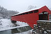
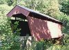
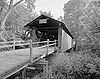
| Barrackville Covered Bridge Barrackville Covered Bridge The Barrackville Covered Bridge spans in a single span across Buffalo Creek near Barrackville, West Virginia. Built by in 1853 by local bridge builder Lemuel Chenoweth, the structure is a modified arched Burr truss, with siding added twenty years after the bridge's construction.It was listed on... |
 |
1853 | 1973-03-30 | Barrackville Barrackville, West Virginia Barrackville is a town in Marion County, West Virginia, United States. The population was 1,288 at the 2000 census. Barrackville was founded in 1767 by William "Indian Billy" Ice and named in honor of an early settler, John Barrack... 39°30′21"N 80°10′5"W |
Marion Marion County, West Virginia | style="float:right;"|As of the census of 2000, there were 56,598 people, 23,652 households, and 15,515 families residing in the county. The population density was 183 people per square mile . There were 26,660 housing units at an average density of 86 per square mile... |
Covered Covered bridge A covered bridge is a bridge with enclosed sides and a roof, often accommodating only a single lane of traffic. Most covered bridges are wooden; some newer ones are concrete or metal with glass sides... Burr truss |
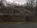
| Bridgeport Lamp Chimney Company Bowstring Concrete Arch Bridge Bridgeport Lamp Chimney Company Bowstring Concrete Arch Bridge The Bridgeport Lamp Chimney Company Bowstring Concrete Arch Bridge is located between Mechanic St. and Baltimore and Ohio Railroad tracks in Bridgeport, West Virginia The bridge was constructed in 1924, designed by Frank McEnteer... |
 |
1924 | 1997-01-27 | Bridgeport Bridgeport, West Virginia Bridgeport is a city in Harrison County, West Virginia, United States. The population was 7,306 at the 2000 census.The town of Bridgeport had its beginning in pre-Revolutionary War times. In 1764, John Simpson entered the area and gave his name to Simpson Creek. Bridgeport was chartered in 1816.... 39°17′3"N 80°15′22"W |
Harrison Harrison County, West Virginia As of the census of 2000, there were 68,652 people, 27,867 households, and 19,088 families residing in the county. The population density was 165 people per square mile . There were 31,112 housing units at an average density of 75 per square mile... |
Concrete Arch Bridge |
| Burnsville Bridge Burnsville Bridge Burnsville Bridge is a historic Pratt-Through Truss bridge located at Burnsville, Braxton County, West Virginia. It was built in 1893, by the Variety Iron Works Company or Cleveland, Ohio and crosses the Little Kanawha River. It consists of two Truss spans and one girder span. The three spans are... |
1893 | 1995-03-17 | Burnsville Burnsville, West Virginia Burnsville is a town in Braxton County, West Virginia, United States, at the confluence of the Little Kanawha River and Saltlick Creek. The population was 481 at the 2000 census... 38°51′19"N 80°39′25"W |
Braxton | Pratt-Through Truss | |
| Carrollton Covered Bridge Carrollton Covered Bridge The Carrollton Covered Bridge, in Barbour County, West Virginia, USA, is the second longest and third oldest surviving covered bridge in the state. The wooden bridge spans the Buckhannon River near Carrollton and was built in 1856. It underwent repairs in 1978 and was added to the National Register... |
 |
1856 | 1981-06-04 | Carrollton Carrollton, West Virginia Carrollton is an unincorporated community in Barbour County in the U.S. state of West Virginia. Carrollton is known for its Carrollton Covered Bridge over the Buckhannon River, listed on the National Register of Historic Places.... 39°5′24"N 80°5′12"W |
Barbour Barbour County, West Virginia As of the census of 2000, there are 15,557 people, 6,123 households, and 4,365 families residing in the county. The population density is 46 people per square mile . There are 7,348 housing units at an average density of 22 per square mile... |
Covered Covered bridge A covered bridge is a bridge with enclosed sides and a roof, often accommodating only a single lane of traffic. Most covered bridges are wooden; some newer ones are concrete or metal with glass sides... Burr Arch |
| Center Point Covered Bridge Center Point Covered Bridge The Center Point Covered Bridge is a historic covered bridge near Center Point, Doddridge County, West Virginia, USA.It was commissioned by the County Court and was built between 1888 and 1890. It spans Pike's Fork of McElroy Creek. The masons were T.C. Ancell and E. Underwood . The carpenters... |
1983-08-29 | Center Point Center Point, West Virginia Center Point is an unincorporated community in northeastern Doddridge County, West Virginia, United States. It lies along Route 23 northeast of the town of West Union, the county seat of Doddridge County. Its elevation is 791 feet... 39°23′22"N 80°38′4"W |
Doddridge Doddridge County, West Virginia As of the census of 2000, there were 7,403 people, 2,845 households, and 2,102 families residing in the county. The population density was 23 people per square mile . There were 3,661 housing units at an average density of 11 per square mile... |
Covered bridge | ||
| Dents Run Covered Bridge Dents Run Covered Bridge Dents Run Covered Bridge is a historic covered bridge located near Laurel Point, Monongalia County, West Virginia. It was built in 1889, and spans Dents Run. The bridge is of Kingpost truss construction and measures 12 feet, 10 inches wide and 40 feet long... |
1889 | 1981-06-04 | Laurel Point 39°37′26"N 80°2′24"W |
Monongalia Monongalia County, West Virginia As of the census of 2000, there were 81,866 people, 33,446 households, and 18,495 families residing in the county. The population density was 227 people per square mile . There were 36,695 housing units at an average density of 102 per square mile... |
Covered Covered bridge A covered bridge is a bridge with enclosed sides and a roof, often accommodating only a single lane of traffic. Most covered bridges are wooden; some newer ones are concrete or metal with glass sides... Kingpost Truss |
|
| Duck Run Cable Suspension Bridge Duck Run Cable Suspension Bridge Duck Run Cable Suspension Bridge, also known as Trubada Swinging Bridge, is a historic cable suspension bridge bridge that spans the Little Kanawha River at Trubada, Gilmer County, West Virginia. The bridge was built in 1922. The bridge is 351 feet, 7 inches, with a main span of 209 feet,... |
1922 | 1997-07-09 | Trubada 38°55′38"N 80°47′28"W |
Gilmer Gilmer County, West Virginia As of the census of 2000, there were 7,160 people, 2,768 households, and 1,862 families residing in the county. The population density was 21 people per square mile . There were 3,621 housing units at an average density of 11 per square mile... |
cable suspension bridge | |
| Elm Grove Stone Arch Bridge Elm Grove Stone Arch Bridge The Elm Grove Stone Arch Bridge, also known as the Monument Place Bridge, is the oldest extant bridge, built in 1817, in the U.S. state of West Virginia. The bridge carries U.S. Route 40 over Little Wheeling Creek in Elm Grove... |
1817 | 1981-08-21 | Wheeling Wheeling, West Virginia Wheeling is a city in Ohio and Marshall counties in the U.S. state of West Virginia; it is the county seat of Ohio County. Wheeling is the principal city of the Wheeling Metropolitan Statistical Area... 40°2′37"N 80°39′32"W |
Ohio Ohio County, West Virginia As of the census of 2000, there were 47,427 people, 19,733 households, and 12,155 families residing in the county. The population density was 447 people per square mile . There were 22,166 housing units at an average density of 209 per square mile... |
Stone Arch | |
| Fish Creek Covered Bridge Fish Creek Covered Bridge The Fish Creek Covered Bridge was built circa 1881 near Hundred, West Virginia. The kingpost truss bridge spans only . It is the last remaining covered bridge in Wetzel County and one of two remaining single kingpost truss bridges in West Virginia. The bridge has been structurally reinforced with... |
 |
1981-06-04 | Hundred Hundred, West Virginia Hundred is a town in Wetzel County, West Virginia, United States. The population was 344 at the 2000 census. It was named for Henry Church and his wife, the first settlers who lived to be 109 and 106. Hundred is the only place in the United States with this name.Hundred is so named because Henry... 39°40′20"N 80°27′9"W |
Wetzel Wetzel County, West Virginia As of the census of 2000, there were 17,693 people, 7,164 households, and 5,079 families residing in the county. The population density was 49 people per square mile . There were 8,313 housing units at an average density of 23 per square mile... |
Covered Covered bridge A covered bridge is a bridge with enclosed sides and a roof, often accommodating only a single lane of traffic. Most covered bridges are wooden; some newer ones are concrete or metal with glass sides... King Post truss |
|
| Fletcher Covered Bridge Fletcher Covered Bridge The Fletcher Covered Bridge is a Multiple King Post covered bridge located near Marshville in Harrison County, West Virginia. The bridge crosses Tenmile Creek is West Virginia bridge number 48-17-03. Stones for the abutments were quarried at the top of a hill near the bridge site... |
 |
1891 | 1981-06-04 | Maken 39°18′20"N 80°28′49"W |
Harrison Harrison County, West Virginia As of the census of 2000, there were 68,652 people, 27,867 households, and 19,088 families residing in the county. The population density was 165 people per square mile . There were 31,112 housing units at an average density of 75 per square mile... |
Covered Covered bridge A covered bridge is a bridge with enclosed sides and a roof, often accommodating only a single lane of traffic. Most covered bridges are wooden; some newer ones are concrete or metal with glass sides... Kingpost Truss |
| Glenville Truss Bridge Glenville Truss Bridge Glenville Truss Bridge is a historic Pratt Through Truss bridge that spans the Little Kanawha River at Glenville, Gilmer County, West Virginia. The bridge was built in 1885. The bridge is 240 feet, 6 inches, long and the main through truss span is 147 feet. It was designed and/or built by... |
1885 | 1998-12-04 | Glenville Glenville, West Virginia Glenville is a town in and the county seat of Gilmer County, West Virginia, United States, along the Little Kanawha River. The population was 1,544 at the 2000 census. It is the home of Glenville State College.-History:... 38°55′58"N 80°50′20"W |
Gilmer Gilmer County, West Virginia As of the census of 2000, there were 7,160 people, 2,768 households, and 1,862 families residing in the county. The population density was 21 people per square mile . There were 3,621 housing units at an average density of 11 per square mile... |
Pratt Through Truss | |
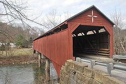
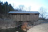
| Herns Mill Covered Bridge Herns Mill Covered Bridge Herns Mill Covered Bridge is a historic covered bridge near Lewisburg, Greenbrier County, West Virginia. It was built in 1884, and is a Queen post truss bridge measuring 10 feet, 6 inches wide and 53 feet, 8 inches long. It has red board-and-batten siding and a galvanized sheet metal... |
 |
1884 | 1981-06-04 | Lewisburg Lewisburg, West Virginia Lewisburg is a city in Greenbrier County, West Virginia, United States. The population was 3,830 at the 2010 census. It is the county seat of Greenbrier County.-Geography:Lewisburg is located at .... 37°49′57"N 80°30′18"W |
Greenbrier Greenbrier County, West Virginia As of the census of 2000, there were 34,453 people, 14,571 households, and 9,922 families residing in the county. The population density was 34 people per square mile . There were 17,644 housing units at an average density of 17 per square mile... |
Covered Covered bridge A covered bridge is a bridge with enclosed sides and a roof, often accommodating only a single lane of traffic. Most covered bridges are wooden; some newer ones are concrete or metal with glass sides... Queen Post Truss |
| High Level Bridge Robert H. Mollohan-Jefferson Street Bridge The Robert H. Mollohan-Jefferson Street Bridge, also known as the Million Dollar Bridge, or the High Level Bridge is located in Fairmont, Marion County, West Virginia. It was dedicated on May 30, 1921. This bridge connects east and west Fairmont, and crosses the Monongahela River. After falling... |
1921 | 1991-12-04 | Fairmont Fairmont, West Virginia Fairmont is a city in Marion County, West Virginia, United States. Nicknamed "The Friendly City". The population was 18,704 at the 2010 census... 39°28′57"N 80°8′27"W |
Marion Marion County, West Virginia | style="float:right;"|As of the census of 2000, there were 56,598 people, 23,652 households, and 15,515 families residing in the county. The population density was 183 people per square mile . There were 26,660 housing units at an average density of 86 per square mile... |
||
| Hokes Mill Covered Bridge Hokes Mill Covered Bridge Hokes Mill Covered Bridge is a historic covered bridge at Ronceverte, Greenbrier County, West Virginia. It was built between 1897 and 1899, and measures 12 feet wide and 81.6 feet long. It has red board-and-batten siding and a standing seam metal roof... |
 |
1981-06-04 | Lewisburg Lewisburg, West Virginia Lewisburg is a city in Greenbrier County, West Virginia, United States. The population was 3,830 at the 2010 census. It is the county seat of Greenbrier County.-Geography:Lewisburg is located at .... 37°41′50"N 80°31′30"W |
Greenbrier Greenbrier County, West Virginia As of the census of 2000, there were 34,453 people, 14,571 households, and 9,922 families residing in the county. The population density was 34 people per square mile . There were 17,644 housing units at an average density of 17 per square mile... |
Covered Covered bridge A covered bridge is a bridge with enclosed sides and a roof, often accommodating only a single lane of traffic. Most covered bridges are wooden; some newer ones are concrete or metal with glass sides... Long Truss |
|
| Indian Creek Covered Bridge Indian Creek Covered Bridge The Indian Creek Covered Bridge is a historic covered bridge near US 219, about 4 miles away from Salt Sulphur Springs, in Monroe County, West Virginia, U.S.A.. It is owned by the Monroe County Historical Society, and was originally built in 1898 by Ray and Oscar Weikel... |
 |
1975-04-01 | Salt Sulphur Springs Salt Sulphur Springs, West Virginia Salt Sulphur Springs is an unincorporated community in Monroe County, West Virginia, United States. Salt Sulphur Springs is located on U.S. Route 219 southwest of Union.... 37°32′50"N 80°34′22"W |
Monroe Monroe County, West Virginia As of the census of 2000, there were 14,583 people, 5,447 households, and 3,883 families residing in the county. The population density was 31 people per square mile . There were 7,267 housing units at an average density of 15 per square mile... |
Covered Covered bridge A covered bridge is a bridge with enclosed sides and a roof, often accommodating only a single lane of traffic. Most covered bridges are wooden; some newer ones are concrete or metal with glass sides... Howe Truss |
|
| Laurel Creek Covered Bridge Laurel Creek Covered Bridge Laurel Creek Covered Bridge is a historic covered bridge located near Lillydale, Monroe County, West Virginia. It was built in 1910, and measures 34 feet, 6 inches long and 13 feet, 2 1/2 inches wide. It has wood siding painted red and a galvanized metal roof... |
 |
1910, 1911 | 1981-06-04 | Lillydale 37°33′40"N 80°37′36"W |
Monroe Monroe County, West Virginia As of the census of 2000, there were 14,583 people, 5,447 households, and 3,883 families residing in the county. The population density was 31 people per square mile . There were 7,267 housing units at an average density of 15 per square mile... |
Covered Covered bridge A covered bridge is a bridge with enclosed sides and a roof, often accommodating only a single lane of traffic. Most covered bridges are wooden; some newer ones are concrete or metal with glass sides... |
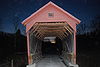
| Locust Creek Covered Bridge | 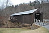 |
1870 | 1981-06-04 | Hillsboro Hillsboro, West Virginia Hillsboro is a town in Pocahontas County, West Virginia, United States. The population was 243 at the 2000 census.- History :Hillsboro was named for pioneer John Hill, from North Carolina, who built a log cabin near what is now Lobelia... 38°4′46"N 80°15′1"W |
Pocahontas Pocahontas County, West Virginia As of the census of 2000, there were 9,131 people, 835 households, and 527 families residing in the county. The population density was 10 people per square mile . There were 7,594 housing units at an average density of 8 per square mile... |
Covered Covered bridge A covered bridge is a bridge with enclosed sides and a roof, often accommodating only a single lane of traffic. Most covered bridges are wooden; some newer ones are concrete or metal with glass sides... Warren Truss |
| Mud River Covered Bridge Mud River Covered Bridge Mud River Covered Bridge is a historic covered bridge over the Mud River at Milton, Cabell County, West Virginia. It was built about 1875, and is a single-span, modified Howe truss structure. It measures approximately 112 feet in length and 14 feet in width... |
 |
1975-06-10 | Milton Milton, West Virginia Milton is a town in Cabell County, West Virginia, United States. The population was 2,206 at the 2000 census.Milton is a part of the Huntington-Ashland, WV-KY-OH Metropolitan Statistical Area . As of the 2000 census, the MSA had a population of 288,649... 38°25′51"N 82°8′22"W |
Cabell Cabell County, West Virginia As of the census of 2000, there were 96,784 people, 41,180 households, and 25,490 families residing in the county. The population density was 344 people per square mile . There were 45,615 housing units at an average density of 162 per square mile... |
Covered Covered bridge A covered bridge is a bridge with enclosed sides and a roof, often accommodating only a single lane of traffic. Most covered bridges are wooden; some newer ones are concrete or metal with glass sides... Modified Howe truss |
|
| Parks's Gap Bridge | 1892 | 1994-11-04 | Martinsburg Martinsburg, West Virginia Martinsburg is a city in the Eastern Panhandle region of West Virginia, United States. The city's population was 14,972 at the 2000 census; according to a 2009 Census Bureau estimate, Martinsburg's population was 17,117, making it the largest city in the Eastern Panhandle and the eighth largest... 39°30′45"N 78°2′11"W |
Berkeley Berkeley County, West Virginia Berkeley County is a county located in the Eastern Panhandle region of the U.S. state of West Virginia. As of 2010, the population is 104,169, making it the second-most populous county in West Virginia, behind Kanawha... |
Modified Howe Truss | |
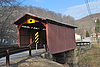
| Philippi Covered Bridge Philippi Covered Bridge The Philippi Covered Bridge, on the Tygart River, is the main local landmark and historical icon of Philippi, West Virginia, USA.The celebrated bridge was commissioned by the General Assembly of Virginia and constructed in 1852 by Lemuel Chenoweth, a well-known Appalachian bridge builder, to... |
 |
1852 | 1972-09-14 | Philippi Philippi, West Virginia Philippi is a city in — and the county seat of — Barbour County, West Virginia, USA. The population was 2,870 at the 2000 census. In 1861, the city was the site of the Battle of Philippi, known as "The Philippi Races"... 39°9′11"N 80°2′37"W |
Barbour Barbour County, West Virginia As of the census of 2000, there are 15,557 people, 6,123 households, and 4,365 families residing in the county. The population density is 46 people per square mile . There are 7,348 housing units at an average density of 22 per square mile... |
Covered Covered bridge A covered bridge is a bridge with enclosed sides and a roof, often accommodating only a single lane of traffic. Most covered bridges are wooden; some newer ones are concrete or metal with glass sides... |
| Rotary Park Bridge Rotary Park Bridge Rotary Park Bridge is a historic arch bridge located in Rotary Park at Huntington, Cabell County, West Virginia. It was built in 1929-1930, and is constructed of native rock-faced, square-cut ashlar in a rustic style. It measures approximately 175 feet long and 30 feet wide.It was listed on the... |
1929, 1930 | 2002-12-12 | Huntington Huntington, West Virginia Huntington is a city in Cabell and Wayne counties in the U.S. state of West Virginia, along the Ohio River. Most of the city is in Cabell County, for which it is the county seat. A small portion of the city, mainly the neighborhood of Westmoreland, is in Wayne County. Its population was 49,138 at... 38°25′7"N 82°23′39"W |
Cabell Cabell County, West Virginia As of the census of 2000, there were 96,784 people, 41,180 households, and 25,490 families residing in the county. The population density was 344 people per square mile . There were 45,615 housing units at an average density of 162 per square mile... |
Rustic | |
| Sarvis Fork Covered Bridge Sarvis Fork Covered Bridge Sarvis Fork Covered Bridge, also known as Sandyville Covered Bridge, is a historic covered bridge located near Sandyville, Jackson County, West Virginia. It was built in 1889-1890 for $64.00 by R. B. Cunningham and G.W. Staats, originally spanning John Carnahan's Fork, a branch of Mill Creek... |
1889, 1890 | 1981-06-04 | Sandyville Sandyville, West Virginia Sandyville is an unincorporated community in north central Jackson County, West Virginia, United States. It lies close to the left fork of Sandy Creek, nestled in the hills between Ravenswood and Ripley. It has a population of 1,721 and an average household income of $41,122.... 38°55′17"N 81°38′41"W |
Jackson | Covered Covered bridge A covered bridge is a bridge with enclosed sides and a roof, often accommodating only a single lane of traffic. Most covered bridges are wooden; some newer ones are concrete or metal with glass sides... Long Truss |
|
| Simpson Creek Covered Bridge Simpson Creek Covered Bridge Simpson Creek Covered Bridge is located in Bridgeport, West Virginia, crossing Simpson Creek off Meadowbrook Road near the entrance to the Meadowbrook Mall. The , multiple-kingpost truss bridge was built in 1881 by Asa Hugill. The current location of the bridge is not the original location... |
 |
1881 | 1981-06-04 | Bridgeport Bridgeport, West Virginia Bridgeport is a city in Harrison County, West Virginia, United States. The population was 7,306 at the 2000 census.The town of Bridgeport had its beginning in pre-Revolutionary War times. In 1764, John Simpson entered the area and gave his name to Simpson Creek. Bridgeport was chartered in 1816.... 39°18′31"N 80°16′47"W |
Harrison Harrison County, West Virginia As of the census of 2000, there were 68,652 people, 27,867 households, and 19,088 families residing in the county. The population density was 165 people per square mile . There were 31,112 housing units at an average density of 75 per square mile... |
Covered Covered bridge A covered bridge is a bridge with enclosed sides and a roof, often accommodating only a single lane of traffic. Most covered bridges are wooden; some newer ones are concrete or metal with glass sides... Multiple Kingpost |
| Sixth Street Railroad Bridge Sixth Street Railroad Bridge Sixth Street Railroad Bridge is a historic railroad bridge spanning the Ohio River at Parkersburg, Wood County, West Virginia and extending into Washington County, Ohio. It was built between 1869 and 1871, and used 50,000 yards of stone for the 53 piers. When built, it was the longest bridge of... |
1869, 1871, 1914 | 1982-12-10 | Parkersburg Parkersburg, West Virginia As of the census of 2000, there were 33,099 people, 14,467 households, and 8,767 families residing in the city. In 2006 the U.S. Census Bureau estimated that Parkersburg's population had decreased 4.4% to 31,755. The population density was 2,800.5 people per square mile . There were 16,100 housing... 39°16′2"N 81°33′32"W |
Wood Wood County, West Virginia As of the census of 2000, there were 87,986 people, 36,275 households, and 24,884 families residing in the county. The population density was 240 people per square mile . There were 39,785 housing units at an average density of 108 per square mile... |
||
| Staats Mill Covered Bridge Staats Mill Covered Bridge Staats Mill Covered Bridge, also known as Tug Fork Covered Bridge, is a historic wooden covered bridge near Ripley in Jackson County, West Virginia, United States. Built in 1887, the Staats Mill Covered Bridge originally crossed the Tug Fork of Big Mill Creek and was named for Enoch Staat's... |
 |
1887 | 1979-05-29 | Staats Mill 38°44′34"N 81°37′34"W |
Jackson | Covered Covered bridge A covered bridge is a bridge with enclosed sides and a roof, often accommodating only a single lane of traffic. Most covered bridges are wooden; some newer ones are concrete or metal with glass sides... Long truss |
| Stouts Mill Bridge Stouts Mill Bridge The Stouts Mill Bridge is a historic camel-back through truss bridge that brings Duskcamp Rd. over Little Kanawha River in Stouts Mill, Gilmer County, West Virginia. The bridge was built in 1897. It was designed and/or built by the Canton Bridge Company.... |
1897 | 1998-12-04 | Stouts Mill 38°53′47"N 80°43′54"W |
Gilmer Gilmer County, West Virginia As of the census of 2000, there were 7,160 people, 2,768 households, and 1,862 families residing in the county. The population density was 21 people per square mile . There were 3,621 housing units at an average density of 11 per square mile... |
camel-back through truss | |
| Van Metre Ford Stone Bridge Van Metre Ford Stone Bridge Van Metre Ford Stone Bridge is a historic stone arch bridge located near Martinsburg, Berkeley County, West Virginia. It was built in 1832, and is a three span bridge crossing Opequon Creek. It is 132 feet long and constructed of ashlar limestone... |
1832 | 1977-08-22 | Martinsburg Martinsburg, West Virginia Martinsburg is a city in the Eastern Panhandle region of West Virginia, United States. The city's population was 14,972 at the 2000 census; according to a 2009 Census Bureau estimate, Martinsburg's population was 17,117, making it the largest city in the Eastern Panhandle and the eighth largest... 39°26′42"N 77°55′40"W |
Berkeley Berkeley County, West Virginia Berkeley County is a county located in the Eastern Panhandle region of the U.S. state of West Virginia. As of 2010, the population is 104,169, making it the second-most populous county in West Virginia, behind Kanawha... |
Stone Arch | |
| Walkersville Covered Bridge Walkersville Covered Bridge Walkersville Covered Bridge is a historic covered bridge near Walkersville, Lewis County, West Virginia. It was built in 1903, and is a Queen post truss bridge measuring 12 feet, 1 1/2 inches wide and 39 feet, 4 inches long. It has red board-and-batten siding and a standing seam metal roof... |
1903 | 1981-06-04 | Walkersville Walkersville, West Virginia Walkersville is an unincorporated community in Lewis County, West Virginia, United States. Walkersville is south of Weston. Walkersville has a post office with ZIP code 26447.... 38°51′30"N 80°27′39"W |
Lewis Lewis County, West Virginia As of the census of 2000, there were 16,919 people, 6,946 households, and 4,806 families residing in the county. The population density was 44 people per square mile . There were 7,944 housing units at an average density of 21 per square mile... |
Covered Covered bridge A covered bridge is a bridge with enclosed sides and a roof, often accommodating only a single lane of traffic. Most covered bridges are wooden; some newer ones are concrete or metal with glass sides... Queenpost Truss |
|
| Wheeling Suspension Bridge Wheeling Suspension Bridge The Wheeling Suspension Bridge is a suspension bridge spanning the main channel of the Ohio River at Wheeling, West Virginia. It was the largest suspension bridge in the world from 1849 until the Queenston-Lewiston Bridge was opened in 1851. It was designed by Charles Ellet Jr., who also worked... |
1849 | 1970-01-26 | Wheeling Wheeling, West Virginia Wheeling is a city in Ohio and Marshall counties in the U.S. state of West Virginia; it is the county seat of Ohio County. Wheeling is the principal city of the Wheeling Metropolitan Statistical Area... 40°4′13"N 80°43′38"W |
Ohio Ohio County, West Virginia As of the census of 2000, there were 47,427 people, 19,733 households, and 12,155 families residing in the county. The population density was 447 people per square mile . There were 22,166 housing units at an average density of 209 per square mile... |
Suspension;Howe truss |