
List of bridges on the National Register of Historic Places in Vermont
Encyclopedia
This is a list of bridge
s and tunnel
s on the National Register of Historic Places
in the U.S. state
of Vermont
.
Bridge
A bridge is a structure built to span physical obstacles such as a body of water, valley, or road, for the purpose of providing passage over the obstacle...
s and tunnel
Tunnel
A tunnel is an underground passageway, completely enclosed except for openings for egress, commonly at each end.A tunnel may be for foot or vehicular road traffic, for rail traffic, or for a canal. Some tunnels are aqueducts to supply water for consumption or for hydroelectric stations or are sewers...
s on the National Register of Historic Places
National Register of Historic Places
The National Register of Historic Places is the United States government's official list of districts, sites, buildings, structures, and objects deemed worthy of preservation...
in the U.S. state
U.S. state
A U.S. state is any one of the 50 federated states of the United States of America that share sovereignty with the federal government. Because of this shared sovereignty, an American is a citizen both of the federal entity and of his or her state of domicile. Four states use the official title of...
of Vermont
Vermont
Vermont is a state in the New England region of the northeastern United States of America. The state ranks 43rd in land area, , and 45th in total area. Its population according to the 2010 census, 630,337, is the second smallest in the country, larger only than Wyoming. It is the only New England...
.
| Name | Image | Built | Listed | Location | County | Type |
|---|---|---|---|---|---|---|
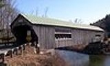
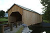
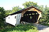
| Arlington Green Covered Bridge Arlington Green Covered Bridge The Arlington Green Covered Bridge is a covered bridge located off Vermont Route 313 in Arlington, Vermont.The bridge crosses Batten Kill.The bridge was built in 1852 and is listed on the National Register of Historic Places.-Recent History:... |
1852 | 1973-08-28 | Arlington 43°6′16"N 73°13′14"W |
Bennington | Town lattice truss | |
| Bartonsville Covered Bridge Bartonsville Covered Bridge The Bartonsville Covered Bridge was a wooden covered bridge in the village of Bartonsville, in Rockingham, Vermont, United States. Built in 1870 by Sanford Granger, the bridge was a lattice truss style with a 151 foot span across the Williams River... (destroyed) |
 |
1871 | 1973-07-02 | Rockingham Rockingham, Vermont Rockingham is a town in Windham County, Vermont, United States, along the Connecticut River. The population was 5,309 at the 2000 census. Rockingham includes the incorporated villages of Bellows Falls and Saxtons River, as well as a large rural area west of Interstate 91.Rockingham has no formal... 43°13′27"N 72°32′12"W |
Windham Windham County, Vermont Windham County is a county located in the U.S. state of Vermont. As of 2010, the population was 44,513. Its shire town is Newfane.-Geography:According to the U.S... |
Town lattice trusses, destroyed in 2011 by flash flooding from Hurricane Irene. |
| Bedell Covered Bridge Bedell Covered Bridge The Bedell Bridge was a Burr truss covered bridge that spanned the Connecticut River between Newbury, Vermont and Haverhill, New Hampshire. Until its most recent destruction in 1979, it was the second longest covered bridge in the United States.- History :... (destroyed) |
 |
1866 | 1975-05-28 | Newbury Newbury, Vermont Newbury could be either of the following places in the U.S. state of Vermont:*Newbury , Vermont*Newbury , Vermont... 44°2′53"N 72°4′20"W |
Orange | Burr arch truss |
| Bennington Falls Covered Bridge | 1889 | 1973-08-28 | Bennington 42°54′46"N 73°14′3"W |
Bennington | Town lattice truss | |
| Best's Covered Bridge | 1973-07-02 | Windsor Windsor, Vermont Windsor is a town in Windsor County, Vermont, United States. The population was 3,756 at the 2000 census.-History:One of the New Hampshire grants, Windsor was chartered as a town on July 6, 1761 by Colonial Governor Benning Wentworth. It was first settled in August 1764 by Captain Steele Smith and... 43°27′19"N 72°30′58"W |
Windsor | |||
| Bloomfield-Nulhegan River Route 102 Bridge | 1937 | 1991-11-14 | Bloomfield Bloomfield, Vermont Bloomfield is a town in Essex County, Vermont, United States. The population was 261 as of the 2000 census. It is part of the Berlin, NH–VT Micropolitan Statistical Area... 44°45′10"N 71°38′48"W |
Essex Essex County, Vermont Essex County is the county located in the northeastern part of the U.S. state of Vermont. As of 2010, the population was 6,306, making it the least-populous county in both Vermont and New England... |
Pratt through truss | |
| Bowers Covered Bridge | 1973-08-28 | Windsor Windsor, Vermont Windsor is a town in Windsor County, Vermont, United States. The population was 3,756 at the 2000 census.-History:One of the New Hampshire grants, Windsor was chartered as a town on July 6, 1761 by Colonial Governor Benning Wentworth. It was first settled in August 1764 by Captain Steele Smith and... 43°27′42"N 72°29′29"W |
Windsor | |||
| Bradley Covered Bridge | 1878 | 1977-06-13 | Lyndon Lyndon, Vermont Lyndon is a town in Caledonia County, Vermont, United States. The population was 5,448 at the 2000 census. Lyndon is the home of Lyndon State College. The town contains one incorporated village, Lyndonville and three unincorporated villages: Lyndon, Lyndon Center, and East Lyndon.Lyndon is the... 44°32′31"N 72°0′38"W |
Caledonia Caledonia County, Vermont Caledonia County is a county located in the U.S. state of Vermont. As of 2010, the population was 31,227. Its shire town is St. Johnsbury.The county was given the Latin name for Scotland, in honor of the many settlers who claimed ancestry there.... |
queenpost truss | |
| Braley Covered Bridge Braley Covered Bridge The Braley Covered Bridge, also called the Johnson Covered Bridge and Upper Blaisdell Covered Bridge, is a wooden covered bridge that crosses the Second Branch of the White River in Randolph, Vermont on Braley Covered Bridge Road. It was listed on the National Register of Historic Places in... |
1974-06-13 | Randolph Randolph, Vermont Randolph is a town in Orange County, Vermont, United States. The population was 4,853 at the 2000 census, making Randolph the largest town in Orange County. The town is a commercial center for many of the smaller, rural farming communities that surround it.... 43°55′42"N 72°33′26"W |
Orange | multiple Kingpost truss | ||
| Bridge 12 | 1929 | 2007-12-20 | Enosburg Enosburg, Vermont Enosburgh is a town in Franklin County, Vermont, United States. The population was 2,788 at the 2000 census. Enosburgh includes the village Enosburg Falls and the locations Bordoville, East Enosburgh, North Enosburgh, Samsonville, West Enosburgh, and Enosburgh Center. Enosburgh was named for Roger... 44°55′11"N 72°45′26"W |
Franklin Franklin County, Vermont Franklin County is a county located in the U.S. state of Vermont. It is part of the Burlington-South Burlington, VT Metropolitan Statistical Area. As of 2010, the population was 47,746. Its shire town is the City of St. Albans.-Geography:... |
Parker through truss | |
| Bridge 15 | 1928 | 2008-8-19 | Sharon Sharon, Vermont Sharon is a town in Windsor County, Vermont, United States. It had a population of 1,411 at the 2000 census. The town is home to The Sharon Academy.-History:... |
Windsor | Parker through truss | |
| Bridge 19 | 1928 | 2007-09-28 | Brookline Brookline, Vermont Brookline is a town in Windham County, Vermont, United States. The population was 467 at the 2000 census.-Geography:According to the United States Census Bureau, the town has a total area of 12.9 square miles , all land... 42°59′50"N 72°38′16"W |
Windham Windham County, Vermont Windham County is a county located in the U.S. state of Vermont. As of 2010, the population was 44,513. Its shire town is Newfane.-Geography:According to the U.S... |
Camelback through truss | |
| Bridge 22 | 2010-11-30 | Bradford Bradford, Vermont Bradford is a town in Orange County, Vermont, United States. The population was 2,619 at the 2000 census.-History:The first settler was John Hosmer in 1765... |
Orange | |||
| Bridge 26 | 1908 | 2006-06-07 | Weybridge Weybridge, Vermont Weybridge is a town in Addison County, Vermont, United States. The population was 824 at the 2000 census.-Geography:According to the United States Census Bureau, the town has a total area of 17.6 square miles , of which 17.0 square miles is land and 0.6 square mile is... 44°4′23"N 73°11′39"W |
Addison Addison County, Vermont Addison County is a county located in the U.S. state of Vermont. In 2010, the population was 36,821. Its shire town is Middlebury.-Geography:... |
Riveted lattice truss | |
| Bridge 31 | 1928 | 2006-08-09 | Waterbury Waterbury, Vermont Waterbury is a town in Washington County in central Vermont, in the United States. It is also the name of a village within that town. The population was 4,915 at the 2000 census.-Economy:-Industry:... 44°20′21"N 72°45′51"W |
Washington Washington County, Vermont Washington County is a county located in the U.S. state of Vermont. As of 2010, the population was 59,534; Vermont's third-most populous county after Chittenden County and Rutland County. Its shire town is Montpelier, the state capital. The center of population of Vermont is located in Washington... |
Parker through truss | |
| Bridge 4 | 2009-11-5 | Poultney Poultney, Vermont Poultney is a village in Rutland County of the U.S. state of Vermont. The village is entirely within the town of Poultney. The population was 1,612 at the 2010 census... |
Rutland | |||
| Bridge 6 | 1928 | 2007-12-20 | Johnson 44°38′3"N 72°41′5"W |
Lamoille | Pratt through truss | |
| Bridge 9 | 1928 | 2007-12-20 | Sheldon Sheldon, Vermont Sheldon is a town in Franklin County, Vermont, United States. The population was 1,990 at the 2000 census. It contains the unincorporated village of Sheldon Springs.-Geography:... 44°54′42"N 72°58′22"W |
Franklin Franklin County, Vermont Franklin County is a county located in the U.S. state of Vermont. It is part of the Burlington-South Burlington, VT Metropolitan Statistical Area. As of 2010, the population was 47,746. Its shire town is the City of St. Albans.-Geography:... |
Parker through truss | |
| Bridge No. 27 | 1918 | 2006-01-11 | Berlin Berlin, Vermont Berlin is a town in Washington County, Vermont, United States. The population was 2,864 at the 2000 census. Being the town between Barre, Vermont and Montpelier, Vermont, the two largest cities in the region, much of the commercial business of the region can be found in Berlin, including parts of... 44°11′22"N 72°38′27"W |
Washington Washington County, Vermont Washington County is a county located in the U.S. state of Vermont. As of 2010, the population was 59,534; Vermont's third-most populous county after Chittenden County and Rutland County. Its shire town is Montpelier, the state capital. The center of population of Vermont is located in Washington... |
Warren pony truss | |
| Bridgewater Corners Bridge | 1928 | 1992-10-29 | Bridgewater Bridgewater, Vermont Bridgewater is a town in Windsor County, Vermont, United States. The population was 980 at the 2000 census. Bridgewater contains the hamlets of Bridgewater Village, Bridgewater Corners, West Bridgewater, and Bridgewater Center... 43°35′12"N 72°39′25"W |
Windsor | Pratt Through Truss Bridge | |
| Brown Covered Bridge Brown Covered Bridge The Brown Covered Bridge is a wooden covered bridge in Shrewsbury, Vermont. Built in 1880 by Nichols Powers, famed Vermont Bridgewright, also builder of Blenheim Bridge, recently lost to flooding in the aftermath of Tropical Storm Irene. Clarendon was the hometown of Mr... |
 |
1880 | 1974-01-21 | Shrewsbury Shrewsbury, Vermont Shrewsbury is a town in Rutland County, Vermont, United States. The town was named for the Earl of Shrewsbury. The population was 1,056 at the 2010 census.Shrewsbury is the home of former U.S. Senator Jim Jeffords... 43°33′58"N 72°55′10"W |
Rutland | Town lattice truss |
| Burrington Covered Bridge | 1974-06-13 | Lyndon Lyndon, Vermont Lyndon is a town in Caledonia County, Vermont, United States. The population was 5,448 at the 2000 census. Lyndon is the home of Lyndon State College. The town contains one incorporated village, Lyndonville and three unincorporated villages: Lyndon, Lyndon Center, and East Lyndon.Lyndon is the... 44°33′13"N 71°58′12"W |
Caledonia Caledonia County, Vermont Caledonia County is a county located in the U.S. state of Vermont. As of 2010, the population was 31,227. Its shire town is St. Johnsbury.The county was given the Latin name for Scotland, in honor of the many settlers who claimed ancestry there.... |
queenpost truss | ||
| Cedar Swamp Covered Bridge Cedar Swamp Covered Bridge Cedar Swamp Covered Bridge is a historic wooden covered bridge in West Salisbury, Vermont.It was built in 1864 and added to the National Register of Historic Places in 1974.... |
1864, 1865 | 1974-09-10 | West Salisbury 43°55′6"N 73°10′28"W |
Addison Addison County, Vermont Addison County is a county located in the U.S. state of Vermont. In 2010, the population was 36,821. Its shire town is Middlebury.-Geography:... |
Town lattice truss | |
| Centre Covered Bridge | 1872, 1873 | 1974-06-20 | Lyndon Lyndon, Vermont Lyndon is a town in Caledonia County, Vermont, United States. The population was 5,448 at the 2000 census. Lyndon is the home of Lyndon State College. The town contains one incorporated village, Lyndonville and three unincorporated villages: Lyndon, Lyndon Center, and East Lyndon.Lyndon is the... 44°32′36"N 72°0′6"W |
Caledonia Caledonia County, Vermont Caledonia County is a county located in the U.S. state of Vermont. As of 2010, the population was 31,227. Its shire town is St. Johnsbury.The county was given the Latin name for Scotland, in honor of the many settlers who claimed ancestry there.... |
Paddleford truss | |
| Chamberlin Mill Covered Bridge Chamberlin Mill Covered Bridge The Chamberlin Mill Covered Bridge, also called Chamberlin Covered Bridge or Whitcomb Covered Bridge, is a covered bridge that crosses the South Wheelock Branch of the Passumpsic River in Lyndon, Vermont.... |
1881 | 1974-07-30 | Lyndon Lyndon, Vermont Lyndon is a town in Caledonia County, Vermont, United States. The population was 5,448 at the 2000 census. Lyndon is the home of Lyndon State College. The town contains one incorporated village, Lyndonville and three unincorporated villages: Lyndon, Lyndon Center, and East Lyndon.Lyndon is the... 44°30′59"N 72°1′0"W |
Caledonia Caledonia County, Vermont Caledonia County is a county located in the U.S. state of Vermont. As of 2010, the population was 31,227. Its shire town is St. Johnsbury.The county was given the Latin name for Scotland, in honor of the many settlers who claimed ancestry there.... |
queenpost truss | |
| Cilley Covered Bridge | 1883 | 1974-09-10 | Tunbridge Tunbridge, Vermont Tunbridge is a town in Orange County, Vermont, United States. As of the 2000 census, the town population was 1,309. The town consists of three village centers, all situated on Vermont Route 110 in the valley of the first branch of the White River... 43°52′59"N 72°30′17"W |
Orange | multiple Kingpost truss | |
| Coburn Covered Bridge | 1851 | 1974-10-09 | East Montpelier East Montpelier, Vermont East Montpelier is a town in Washington County, Vermont, United States. The population was 2,578 at the 2000 census.-Geography:According to the United States Census Bureau, the town has a total area of 32.1 square miles , of which 32.0 square miles is land and 0.1 square mile is... 44°16′51"N 72°27′18"W |
Washington Washington County, Vermont Washington County is a county located in the U.S. state of Vermont. As of 2010, the population was 59,534; Vermont's third-most populous county after Chittenden County and Rutland County. Its shire town is Montpelier, the state capital. The center of population of Vermont is located in Washington... |
queenpost truss | |
| Colburn Bridge | 1899 | 1990-10-11 | Pittsford Pittsford, Vermont Pittsford is a town in Rutland County, Vermont, United States. The town was named for William Pitt. As of the 2010 census, the town population was 2,991. Pittsford was first settled as a frontier town in 1769, about north of Bennington... 43°42′25"N 73°1′17"W |
Rutland | Masonry arch bridge | |
| Cold River Bridge | 1928 | 1991-11-14 | Clarendon Clarendon, Vermont Clarendon is a town in Rutland County, Vermont, United States. The population was 2,571 at the 2010 census. Clarendon spans U.S. Route 7 and is split by the highway, the Cold River and Mill River, Otter Creek, and the Green Mountains into the villages of Clarendon, West Clarendon, East Clarendon,... 43°34′12"N 72°57′59"W |
Rutland | Parker through truss | |
| Columbia Covered Bridge | 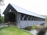 |
1912 | 1976-12-12 | Lemington 44°51′12"N 71°33′5"W |
Essex Essex County, Vermont Essex County is the county located in the northeastern part of the U.S. state of Vermont. As of 2010, the population was 6,306, making it the least-populous county in both Vermont and New England... |
Howe truss |
| Comstock Covered Bridge Comstock Covered Bridge (Montgomery, Vermont) The Comstock Covered Bridge is a wooden covered bridge that crosses the Trout River in Montgomery, Vermont on Comstock Bridge Road. It was listed on the National Register of Historic Places in 1974.... |
1883 | 1974-11-19 | Montgomery Montgomery, Vermont Montgomery is a town in Franklin County, Vermont, United States. The population, according to 2010 census United States Census Bureau is 1,201. In 1963, part of Averys Gore in Franklin County became part of Montgomery, with the other section becoming part of Belvidere.-Geography:According to the... 44°53′59"N 72°38′39"W |
Franklin Franklin County, Vermont Franklin County is a county located in the U.S. state of Vermont. It is part of the Burlington-South Burlington, VT Metropolitan Statistical Area. As of 2010, the population was 47,746. Its shire town is the City of St. Albans.-Geography:... |
Town lattice truss | |
| Cooley Covered Bridge | 1849 | 1974-01-24 | Pittsford Pittsford, Vermont Pittsford is a town in Rutland County, Vermont, United States. The town was named for William Pitt. As of the 2010 census, the town population was 2,991. Pittsford was first settled as a frontier town in 1769, about north of Bennington... 43°41′24"N 73°1′45"W |
Rutland | Town lattice truss | |
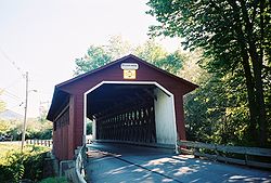
| Cornish-Windsor Covered Bridge Cornish-Windsor Covered Bridge The Cornish–Windsor Covered Bridge is a covered bridge that spans the Connecticut River between Cornish, New Hampshire and Windsor, Vermont. It was the longest covered bridge still standing in the United States until the Smolen–Gulf Bridge opened in Ohio in 2008.While the Old Blenheim Bridge had... |
 |
1866 | 1976-11-21 | Windsor Windsor, Vermont Windsor is a town in Windsor County, Vermont, United States. The population was 3,756 at the 2000 census.-History:One of the New Hampshire grants, Windsor was chartered as a town on July 6, 1761 by Colonial Governor Benning Wentworth. It was first settled in August 1764 by Captain Steele Smith and... 43°28′26"N 72°23′1"W |
Windsor | Town lattice truss |
| Creamery Covered Bridge | 1879 | 1973-08-28 | Brattleboro Brattleboro, Vermont Brattleboro, originally Brattleborough, is a town in Windham County, Vermont, United States, located in the southeast corner of the state, along the state line with New Hampshire. The population was 12,046 at the 2010 census... 42°50′58"N 72°35′12"W |
Windham Windham County, Vermont Windham County is a county located in the U.S. state of Vermont. As of 2010, the population was 44,513. Its shire town is Newfane.-Geography:According to the U.S... |
Town lattice truss | |
| Dean Covered Bridge | 1974-09-10 | Brandon 43°46′43"N 73°5′51"W |
Rutland | Town lattice truss | ||
| Depot Covered Bridge | 1974-01-21 | Pittsford Pittsford, Vermont Pittsford is a town in Rutland County, Vermont, United States. The town was named for William Pitt. As of the 2010 census, the town population was 2,991. Pittsford was first settled as a frontier town in 1769, about north of Bennington... 43°42′34"N 73°2′36"W |
Rutland | Town lattice truss | ||
| Douglas & Jarvis Patent Parabolic Truss Iron Bridge | 1887 | 1974-03-21 | Highgate Falls 44°56′3"N 73°2′53"W |
Franklin Franklin County, Vermont Franklin County is a county located in the U.S. state of Vermont. It is part of the Burlington-South Burlington, VT Metropolitan Statistical Area. As of 2010, the population was 47,746. Its shire town is the City of St. Albans.-Geography:... |
Parabolic Truss Iron | |
| East Fairfield Covered Bridge East Fairfield Covered Bridge The East Fairfield Covered Bridge is a covered bridge that crosses Black Creek off State Route 108 in Fairfield, Vermont. It was listed on the National Register of Historic Places in 1974.The bridge is of Queen post truss design by an unknown builder.... |
 |
1974-11-19 | East Fairfield 44°47′8"N 72°51′49"W |
Franklin Franklin County, Vermont Franklin County is a county located in the U.S. state of Vermont. It is part of the Burlington-South Burlington, VT Metropolitan Statistical Area. As of 2010, the population was 47,746. Its shire town is the City of St. Albans.-Geography:... |
queenpost truss | |
| East Putney Brook Stone Arch Bridge | 1902 | 1976-12-12 | East Putney 42°59′9"N 72°28′9"W |
Windham Windham County, Vermont Windham County is a county located in the U.S. state of Vermont. As of 2010, the population was 44,513. Its shire town is Newfane.-Geography:According to the U.S... |
Masonry arch | |
| East Shoreham Covered Railroad Bridge | 1897 | 1974-06-13 | Shoreham Shoreham, Vermont Shoreham is a town in Addison County, Vermont, United States. The population was 1,222 at the 2000 census.-Geography:According to the United States Census Bureau, the town has a total area of 46.3 square miles , of which 43.5 square miles is land and 2.8 square miles is... 43°51′33"N 73°15′22"W |
Addison Addison County, Vermont Addison County is a county located in the U.S. state of Vermont. In 2010, the population was 36,821. Its shire town is Middlebury.-Geography:... |
||
| Fairfax Covered Bridge Maple Street Covered Bridge The Maple Street Covered Bridge, also called the Lower Covered Bridge, is a covered bridge that crosses Mill Brook off State Route 104 in Fairfax, Vermont. It was listed on the National Register of Historic Places in 1974.... |
 |
1974-11-05 | Fairfax Fairfax, Vermont Fairfax is a town in Franklin County, Vermont, United States. The population was 3,765 at the 2000 census.-Geography:According to the United States Census Bureau, the town has a total area of 40.5 square miles , of which, 40.2 square miles of it is land and 0.3 square miles of it ... 44°39′49"N 73°0′39"W |
Franklin Franklin County, Vermont Franklin County is a county located in the U.S. state of Vermont. It is part of the Burlington-South Burlington, VT Metropolitan Statistical Area. As of 2010, the population was 47,746. Its shire town is the City of St. Albans.-Geography:... |
Town lattice trusses | |
| Fisher Covered Railroad Bridge | 1908 | 1974-10-01 | Wolcott Wolcott, Vermont Wolcott is a town in Lamoille County, Vermont, United States. The town was named for General Oliver Wolcott, a signer of the Declaration of Independence... 44°31′56"N 72°25′43"W |
Lamoille | Louvered Mointor Type | |
| Flint Covered Bridge | 1845 | 1974-09-10 | Tunbridge Tunbridge, Vermont Tunbridge is a town in Orange County, Vermont, United States. As of the 2000 census, the town population was 1,309. The town consists of three village centers, all situated on Vermont Route 110 in the valley of the first branch of the White River... 43°56′56"N 72°27′31"W |
Orange | queenpost truss | |
| Follett Stone Arch Bridge Historic District | 1976-12-12 | Townshend Townshend, Vermont Townshend is a town in Windham County, Vermont, United States. The town was named for the Townshend family, powerful figures in British politics... |
Windham Windham County, Vermont Windham County is a county located in the U.S. state of Vermont. As of 2010, the population was 44,513. Its shire town is Newfane.-Geography:According to the U.S... |
|||
| Foundry Bridge | 1889 | 2007-07-11 | Tunbridge Tunbridge, Vermont Tunbridge is a town in Orange County, Vermont, United States. As of the 2000 census, the town population was 1,309. The town consists of three village centers, all situated on Vermont Route 110 in the valley of the first branch of the White River... 43°54′52"N 72°28′37"W |
Orange | Warren pony truss | |
| Fuller Covered Bridge Fuller Covered Bridge The Fuller Covered Bridge, also known as the Blackfalls Covered Bridge is a wooden covered bridge that crosses Black Falls Brook in Montgomery, Vermont on Fuller Bridge Road... |
1890 | 1974-12-23 | Montgomery Montgomery, Vermont Montgomery is a town in Franklin County, Vermont, United States. The population, according to 2010 census United States Census Bureau is 1,201. In 1963, part of Averys Gore in Franklin County became part of Montgomery, with the other section becoming part of Belvidere.-Geography:According to the... 44°54′13"N 72°38′23"W |
Franklin Franklin County, Vermont Franklin County is a county located in the U.S. state of Vermont. It is part of the Burlington-South Burlington, VT Metropolitan Statistical Area. As of 2010, the population was 47,746. Its shire town is the City of St. Albans.-Geography:... |
Town lattice trusses | |
| Gates Farm Covered Bridge Gates Farm Covered Bridge The Gates Farm Covered Bridge is a covered bridge that crosses the Seymour River off State Route 15 in Cambridge, Vermont. It was listed on the National Register of Historic Places in 1974.The bridge is of Burr arch design, built by George W. Holmes.... |
 |
1897 | 1974-11-19 | Cambridge Cambridge, Vermont Cambridge is a town in Lamoille County, Vermont, United States. The population was 3,186 at the 2000 U.S. Census. Cambridge includes the village of Jeffersonville.-History:... 44°38′44"N 72°52′23"W |
Lamoille | Timber Burr arch truss |
| Gifford Covered Bridge Gifford Covered Bridge The Gifford Covered Bridge, also called the C.K. Smith Covered Bridge, is a wooden covered bridge that crosses the Second Branch of the White River in Randolph, Vermont on Hyde Road. It was listed on the National Register of Historic Places in 1974.... |
1974-07-30 | East Randolph 43°55′0"N 72°33′25"W |
Orange | multiple Kingpost truss | ||
| Gilead Brook Bridge | 1928 | 1990-10-11 | Bethel Bethel, Vermont Bethel is a town in Windsor County, Vermont, United States. The population was 1,968 at the 2000 census. The town includes the locations of Bethel-Gilead, East Bethel, Lilliesville, Lympus , and West Bethel... 43°52′25"N 72°38′52"W |
Windsor | Warren deck truss bridge | |
| Gold Brook Covered Bridge Gold Brook Covered Bridge Gold Brook Covered Bridge, also known as Stowe Hollow Bridge or Emily's Bridge, is a small wooden covered bridge in the town of Stowe, Lamoille County, Vermont, running Covered Bridge Road over Gold Brook... |
1974-10-01 | Stowe Stowe, Vermont Stowe is a town in Lamoille County, Vermont, United States. The population was 4,339 at the 2000 census. Tourism is a significant industry.-Geography:... 44°26′25"N 72°40′49"W |
Lamoille | timber Howe truss | ||
| Gorham Covered Bridge | 1841 | 1974-02-12 | Proctor Proctor, Vermont -Notable people:* Bernard Joseph Flanagan, bishop* F. Ray Keyser, governor of Vermont* Frank Charles Partridge, senator* Fletcher Dutton Proctor, governor of Vermont* Mortimer Robinson Proctor, governor of Vermont... 43°40′48"N 73°2′17"W |
Rutland | Town lattice truss | |
| Gould's Mill Bridge | 1929 | 2006-02-01 | Springfield Springfield, Vermont Springfield is a town in Windsor County, Vermont, United States. The population was 9,373 at the 2010 census.-History:One of the New Hampshire grants, the township was chartered on August 20, 1761 by Governor Benning Wentworth and awarded to Gideon Lyman and 61 others... 43°16′22"N 72°27′16"W |
Windsor | Baltimore through truss | |
| Great Eddy Covered Bridge Great Eddy Covered Bridge The Great Eddy Covered Bridge, also called the Big Eddy Covered Bridge or Waitsfield Covered Bridge, is a wooden covered bridge that crosses the Mad River in Waitsfield, Vermont on Bridge Street. It was listed on the National Register of Historic Places in 1974.The bridge is of burr arch truss... |
1833 | 1974-09-06 | Waitsfield Waitsfield, Vermont Waitsfield is a town in Washington County, Vermont, United States. The population was 1,659 at the 2000 census. It was created by Vermont charter on February 25, 1782... 44°11′22"N 72°49′26"W |
Washington Washington County, Vermont Washington County is a county located in the U.S. state of Vermont. As of 2010, the population was 59,534; Vermont's third-most populous county after Chittenden County and Rutland County. Its shire town is Montpelier, the state capital. The center of population of Vermont is located in Washington... |
Burr truss | |
| Green River Covered Bridge | 1973-08-28 | Guilford Guilford, Vermont Guilford is a town in Windham County, Vermont, United States. The town was named for Francis North, 1st Earl of Guilford. The population was 2,046 at the 2000 census.- Geography :... 42°46′31"N 72°40′4"W |
Windham Windham County, Vermont Windham County is a county located in the U.S. state of Vermont. As of 2010, the population was 44,513. Its shire town is Newfane.-Geography:According to the U.S... |
Town lattice truss | ||
| Greenbanks Hollow Covered Bridge | 1974-06-13 | Danville Danville, Vermont Danville is a town in Caledonia County, Vermont, United States. It was named for the 18th-century French cartographer Jean-Baptiste Bourguignon d'Anville... 44°22′38"N 72°7′20"W |
Caledonia Caledonia County, Vermont Caledonia County is a county located in the U.S. state of Vermont. As of 2010, the population was 31,227. Its shire town is St. Johnsbury.The county was given the Latin name for Scotland, in honor of the many settlers who claimed ancestry there.... |
queenpost truss | ||
| Grist Mill Covered Bridge Grist Mill Covered Bridge The Grist Mill Covered Bridge also known as the Scott Covered Bridge and Bryant Covered Bridge is a covered bridge that crosses the Brewster River off State Route 108 in Cambridge, Vermont. The bridge has historically also been called Canyon Covered Bridge... |
 |
1974-06-13 | Cambridge Cambridge, Vermont Cambridge is a town in Lamoille County, Vermont, United States. The population was 3,186 at the 2000 U.S. Census. Cambridge includes the village of Jeffersonville.-History:... 44°38′11"N 72°49′32"W |
Lamoille | Timber Burr arch truss | |
| Hall Covered Bridge | 1867 | 1973-08-28 | Bellows Falls Bellows Falls, Vermont Bellows Falls is an incorporated village located in the town of Rockingham in Windham County, Vermont, United States. The population was 3,165 at the 2000 census... 43°8′12"N 72°29′16"W |
Windham Windham County, Vermont Windham County is a county located in the U.S. state of Vermont. As of 2010, the population was 44,513. Its shire town is Newfane.-Geography:According to the U.S... |
Town lattice truss | |
| Halpin Covered Bridge Halpin Covered Bridge The Halpin Covered Bridge, also called the High Covered Bridge, is a wooden covered bridge that crosses the Muddy Branch of the New Haven River in Middlebury, Vermont on Halpin Covered Bridge Road. It was listed on the National Register of Historic Places in 1974.The bridge is of Town lattice design... |
1974-09-10 | Middlebury 44°3′0"N 73°8′28"W |
Addison Addison County, Vermont Addison County is a county located in the U.S. state of Vermont. In 2010, the population was 36,821. Its shire town is Middlebury.-Geography:... |
Town Lattice Truss | ||
| Hammond Covered Bridge Hammond Covered Bridge Hammond Covered Bridge is a town lattice covered bridge spanning Otter Creek in Pittsford, Vermont. It was built in 1842 and added to the National Register of Historic Places on January 21, 1974. The bridge is closed to vehicle traffic and is bypassed by Kendall Hill Road.... |
1842 | 1974-01-21 | Pittsford Pittsford, Vermont Pittsford is a town in Rutland County, Vermont, United States. The town was named for William Pitt. As of the 2010 census, the town population was 2,991. Pittsford was first settled as a frontier town in 1769, about north of Bennington... 43°43′14"N 73°3′14"W |
Rutland | Town lattice truss | |
| Hectorville Covered Bridge | 1974-11-20 | Montgomery Montgomery, Vermont Montgomery is a town in Franklin County, Vermont, United States. The population, according to 2010 census United States Census Bureau is 1,201. In 1963, part of Averys Gore in Franklin County became part of Montgomery, with the other section becoming part of Belvidere.-Geography:According to the... 44°51′13"N 72°36′50"W |
Franklin Franklin County, Vermont Franklin County is a county located in the U.S. state of Vermont. It is part of the Burlington-South Burlington, VT Metropolitan Statistical Area. As of 2010, the population was 47,746. Its shire town is the City of St. Albans.-Geography:... |
Town lattice truss Disassembled and stored awaiting restoration |
||
| Henry Covered Bridge |  |
1973-08-28 | Bennington 42°54′45"N 73°15′18"W |
Bennington | Town lattice truss | |
| Holmes Creek Covered Bridge Holmes Creek Covered Bridge The Holmes Creek Covered Bridge, also called the Lakeshore Covered Bridge, is a wooden covered bridge that crosses Holmes Creek in Charlotte, Vermont on Lake Road. It was listed on the National Register of Historic Places in 1974.... |
ca 1870 | 1974-09-06 | Charlotte Charlotte, Vermont Charlotte is a town in Chittenden County, Vermont, United States. The town was named for Sofia Charlotte of Mecklenburg-Strelitz, youngest daughter of Duke Charles Louis Frederick of Mecklenburg-Strelitz.The population was 3,569 at the 2000 census.... 44°19′59"N 73°17′40"W |
Chittenden Chittenden County, Vermont Chittenden County is a county located in the U.S. state of Vermont. As of 2010, the population was 156,545. Its shire town is Burlington. Chittenden is the most populous county in the state, with more than twice as many residents as Vermont's second-most populous county, Rutland.Chittenden County... |
king post with tied arch | |
| Hopkins Covered Bridge Hopkins Covered Bridge The Hopkins Covered Bridge is a wooden covered bridge that crosses the Trout River in Enosburg, Vermont on Hopkins Bridge Road. It was listed on the National Register of Historic Places in 1974.... |
1875 | 1974-11-20 | Enosburg Enosburg, Vermont Enosburgh is a town in Franklin County, Vermont, United States. The population was 2,788 at the 2000 census. Enosburgh includes the village Enosburg Falls and the locations Bordoville, East Enosburgh, North Enosburgh, Samsonville, West Enosburgh, and Enosburgh Center. Enosburgh was named for Roger... 44°55′15"N 72°40′23"W |
Franklin Franklin County, Vermont Franklin County is a county located in the U.S. state of Vermont. It is part of the Burlington-South Burlington, VT Metropolitan Statistical Area. As of 2010, the population was 47,746. Its shire town is the City of St. Albans.-Geography:... |
Town lattice truss | |
| Howe Covered Bridge | 1879 | 1974-09-10 | Tunbridge Tunbridge, Vermont Tunbridge is a town in Orange County, Vermont, United States. As of the 2000 census, the town population was 1,309. The town consists of three village centers, all situated on Vermont Route 110 in the valley of the first branch of the White River... 43°51′53"N 72°29′58"W |
Orange | multiple Kingpost truss | |
| Hutchins Covered Bridge Hutchins Covered Bridge The Hutchins Covered Bridge is a wooden covered bridge that crosses the South Branch of the Trout River in Montgomery, Vermont on Hutchins Bridge Road... |
1883 | 1974-12-30 | Montgomery Montgomery, Vermont Montgomery is a town in Franklin County, Vermont, United States. The population, according to 2010 census United States Census Bureau is 1,201. In 1963, part of Averys Gore in Franklin County became part of Montgomery, with the other section becoming part of Belvidere.-Geography:According to the... 44°51′30"N 72°36′45"W |
Franklin Franklin County, Vermont Franklin County is a county located in the U.S. state of Vermont. It is part of the Burlington-South Burlington, VT Metropolitan Statistical Area. As of 2010, the population was 47,746. Its shire town is the City of St. Albans.-Geography:... |
Town lattice trusses | |
| Iron Bridge at Howard Hill Road | 1890 | 1982-09-09 | Cavendish Cavendish, Vermont Cavendish is a town in Windsor County, Vermont, United States. The town was named after William Cavendish, Duke of Devonshire. The population was 1,470 at the 2000 census... 43°24′16"N 72°34′32"W |
Windsor | Pratt through truss | |
| Jaynes Covered Bridge | 1974-10-01 | Waterville Waterville, Vermont Waterville is a town in Lamoille County, Vermont, United States. The population was 697 at the 2000 census.-Geography:According to the United States Census Bureau, the town has a total area of 16.4 square miles , of which 16.4 square miles is land and 0.06% is water.-Demographics:As... 44°42′43"N 72°45′23"W |
Lamoille | |||
| Jeffersonville Bridge | 1931 | 1991-11-14 | Cambridge Cambridge, Vermont Cambridge is a town in Lamoille County, Vermont, United States. The population was 3,186 at the 2000 U.S. Census. Cambridge includes the village of Jeffersonville.-History:... 44°38′57"N 72°49′51"W |
Lamoille | Parker through truss | |
| Kendron Brook Bridge | 1992-08-27 | Woodstock 43°34′53"N 72°30′55"W |
Windsor | Masonry arch bridge | ||
| Kidder Covered Bridge | 1973-07-02 | Grafton Grafton, Vermont Grafton is a town in Windham County, Vermont, United States. The population was 649 at the 2000 census.-History:The town was founded as Thomlinson, but renaming rights were auctioned in 1791. The high bidder, who reportedly offered "five dollars and a jug of rum," changed the name to Grafton after... 43°10′8"N 72°36′21"W |
Windham Windham County, Vermont Windham County is a county located in the U.S. state of Vermont. As of 2010, the population was 44,513. Its shire town is Newfane.-Geography:According to the U.S... |
Queenpost through truss | ||
| Kingsbury Covered Bridge Kingsbury Covered Bridge The Gifford Covered Bridge, also called the Hyde Covered Bridge, is a wooden covered bridge that crosses the Second Branch of the White River in Randolph, Vermont on Kingsbury Road. It was listed on the National Register of Historic Places in 1974.... |
1904 | 1974-07-30 | East Randolph 43°52′52"N 72°34′56"W |
Orange | multiple Kingpost truss | |
| Kingsley Covered Bridge Kingsley Covered Bridge The Kingsley Covered Bridge is a wooden covered bridge in Clarendon, Vermont. Built in 1836 by Timothy K. Horton, the bridge is a town lattice style with a 120 foot span across the Mill River... |
 |
1974-02-12 | Clarendon Clarendon, Vermont Clarendon is a town in Rutland County, Vermont, United States. The population was 2,571 at the 2010 census. Clarendon spans U.S. Route 7 and is split by the highway, the Cold River and Mill River, Otter Creek, and the Green Mountains into the villages of Clarendon, West Clarendon, East Clarendon,... 43°31′25"N 72°56′30"W |
Rutland | Town lattice truss | |
| Lamoille River Route 15-A Bridge | 1928 | 1991-11-14 | Morristown Morristown, Vermont Morristown is a town in Lamoille County, Vermont, United States. The population was 5,139 at the 2000 census.-Geography:According to the United States Census Bureau, the town has a total area of 51.6 square miles , of which 51.3 square miles is land and 0.3 square mile is... 44°33′51"N 72°34′1"W |
Lamoille | Pratt through truss | |
| Larkin Covered Bridge | 1902 | 1974-07-30 | Tunbridge Tunbridge, Vermont Tunbridge is a town in Orange County, Vermont, United States. As of the 2000 census, the town population was 1,309. The town consists of three village centers, all situated on Vermont Route 110 in the valley of the first branch of the White River... 43°55′22"N 72°27′56"W |
Orange | multiple kingpost truss | |
| Lincoln Covered Bridge | 1877 | 1973-08-28 | Woodstock 43°36′2"N 72°34′10"W |
Windsor | Pratt truss system | |
| Longley Covered Bridge Longley Covered Bridge The Longley Covered Bridge, also known as the Harnois Covered Bridge is a wooden covered bridge that crosses the Trout River in Montgomery, Vermont on Longley Road... |
1863 | 1974-12-30 | Montgomery Montgomery, Vermont Montgomery is a town in Franklin County, Vermont, United States. The population, according to 2010 census United States Census Bureau is 1,201. In 1963, part of Averys Gore in Franklin County became part of Montgomery, with the other section becoming part of Belvidere.-Geography:According to the... 44°54′25"N 72°39′21"W |
Franklin Franklin County, Vermont Franklin County is a county located in the U.S. state of Vermont. It is part of the Burlington-South Burlington, VT Metropolitan Statistical Area. As of 2010, the population was 47,746. Its shire town is the City of St. Albans.-Geography:... |
Town lattice trusses | |
| Lower Cox Brook Covered Bridge Lower Cox Brook Covered Bridge The Lower Cox Brook Covered Bridge is a wooden covered bridge that crosses Cox Brook in Northfield, Vermont on Cox Brook Road. It was listed on the National Register of Historic Places in 1974.The bridge is of Queen post truss design... |
1872 | 1974-10-15 | Northfield Northfield, Vermont Northfield is a town in Washington County, Vermont, United States. It lies in a valley within the Green Mountains, and has been the home of Norwich University since 1866. The town contains the village of Northfield, where over half of its population lives. The population was 6,207 at the 2010... 44°10′21"N 72°39′12"W |
Washington Washington County, Vermont Washington County is a county located in the U.S. state of Vermont. As of 2010, the population was 59,534; Vermont's third-most populous county after Chittenden County and Rutland County. Its shire town is Montpelier, the state capital. The center of population of Vermont is located in Washington... |
queenpost truss | |
| Marble Bridge | 1915 | 1991-11-14 | Proctor Proctor, Vermont -Notable people:* Bernard Joseph Flanagan, bishop* F. Ray Keyser, governor of Vermont* Frank Charles Partridge, senator* Fletcher Dutton Proctor, governor of Vermont* Mortimer Robinson Proctor, governor of Vermont... 43°39′40"N 73°2′2"W |
Rutland | Reinforced concrete bridge | |
| Martin Covered Bridge | 1890 | 1974-10-09 | Marshfield 44°17′7"N 72°24′48"W |
Washington Washington County, Vermont Washington County is a county located in the U.S. state of Vermont. As of 2010, the population was 59,534; Vermont's third-most populous county after Chittenden County and Rutland County. Its shire town is Montpelier, the state capital. The center of population of Vermont is located in Washington... |
Single span queenpost truss | |
| Martin's Mill Covered Bridge | 1973-08-28 | Hartland Hartland, Vermont Hartland is a town in Windsor County, Vermont, United States. The population was 3,223 at the 2000 census.-Geography:According to the United States Census Bureau, the town has a total area of 45.2 square miles , of which 45.0 square miles is land and 0.2 square mile is water... 43°31′56"N 72°23′47"W |
Windsor | Town lattice truss | ||
| Medburyville Bridge | 1990-11-08 | Wilmington Wilmington, Vermont Wilmington is a town in Windham County, Vermont, United States. The population was 2,225 at the 2000 census.-History:The town was chartered in 1751 by Benning Wentworth, colonial governor of New Hampshire. It was named in honor of Spencer Compton, 1st Earl of Wilmington... 42°52′16"N 72°55′12"W |
Windham Windham County, Vermont Windham County is a county located in the U.S. state of Vermont. As of 2010, the population was 44,513. Its shire town is Newfane.-Geography:According to the U.S... |
Warren through truss | ||
| Middlebury Gorge Concrete Arch Bridge | 1924 | 1991-11-14 | Middlebury 43°58′12"N 73°5′11"W |
Addison Addison County, Vermont Addison County is a county located in the U.S. state of Vermont. In 2010, the population was 36,821. Its shire town is Middlebury.-Geography:... |
Concrete arch bridge | |
| Middlesex-Winooski River Bridge | 1928 | 1991-11-14 | Middlesex Middlesex, Vermont Middlesex is a town in Washington County, Vermont, United States. The population was 1,729 at the 2000 census.-Geography:According to the United States Census Bureau, the town has a total area of 39.9 square miles , of which, 39.7 square miles of it is land and 0.2 square miles of... 44°18′22"N 72°41′48"W |
Washington Washington County, Vermont Washington County is a county located in the U.S. state of Vermont. As of 2010, the population was 59,534; Vermont's third-most populous county after Chittenden County and Rutland County. Its shire town is Montpelier, the state capital. The center of population of Vermont is located in Washington... |
Pratt through truss bridge | |
| Mill Covered Bridge Mill Covered Bridge (Belvidere, Vermont) The Mill Covered Bridge is a wooden covered bridge that crosses the Lamoille River in Belvidere, Vermont on Back Road. It was listed on the National Register of Historic Places in 1974.The bridge is of Queen post design built by Lewis Robinson.... |
1890 | 1974-11-19 | Belvidere Belvidere, Vermont Belvidere is a town in Lamoille County, Vermont, United States. The population was 294 at the 2000 census. Belvidere contains the locations Belvidere Center, Belvidere Corners and Belvidere Junction... 44°29′31"N 72°44′29"W |
Lamoille | Queenpost truss | |
| Mill Covered Bridge | 1883 | 1974-07-30 | Tunbridge Tunbridge, Vermont Tunbridge is a town in Orange County, Vermont, United States. As of the 2000 census, the town population was 1,309. The town consists of three village centers, all situated on Vermont Route 110 in the valley of the first branch of the White River... 43°53′29"N 72°29′31"W |
Orange | multiple Kingpost truss | |
| Missisquoi River Bridge | 1929 | 1990-10-11 | Richford Richford, Vermont Richford is a town in Franklin County, Vermont, United States. The population was 2,321 at the 2000 census.Richford is the birthplace of R.G. LeTourneau, American industrialist who founded LeTourneau University in Longview, Texas.-Geography:... 45°0′49"N 72°35′16"W |
Franklin Franklin County, Vermont Franklin County is a county located in the U.S. state of Vermont. It is part of the Burlington-South Burlington, VT Metropolitan Statistical Area. As of 2010, the population was 47,746. Its shire town is the City of St. Albans.-Geography:... |
Parker through truss bridge | |
| Montgomery Covered Bridge Montgomery Covered Bridge The Montgomery Covered Bridge, also known as the Lower Covered Bridge is a wooden covered bridge that crosses the North Branch of the Lamoille River in Waterville, Vermont on Montgomery Road. It was listed on the National Register of Historic Places in 1974.The bridge is of Queen post design built... |
1974-10-18 | Waterville Waterville, Vermont Waterville is a town in Lamoille County, Vermont, United States. The population was 697 at the 2000 census.-Geography:According to the United States Census Bureau, the town has a total area of 16.4 square miles , of which 16.4 square miles is land and 0.06% is water.-Demographics:As... 44°42′20"N 72°45′39"W |
Lamoille | |||
| Morgan Covered Bridge Morgan Covered Bridge The Morgan Covered Bridge, also known as the Upper Covered Bridge is a wooden covered bridge that crosses the Lamoille River in Belvidere, Vermont on Morgan Bridge Road... |
1887 | 1974-11-19 | Belvidere Belvidere, Vermont Belvidere is a town in Lamoille County, Vermont, United States. The population was 294 at the 2000 census. Belvidere contains the locations Belvidere Center, Belvidere Corners and Belvidere Junction... 44°44′36"N 72°43′37"W |
Lamoille | ||
| Mount Orne Covered Bridge Mount Orne Covered Bridge The Mount Orne Bridge is a wooden Howe truss bridge over the Connecticut River located between Lancaster, New Hampshire and Lunenburg, Vermont.- History :... |
 |
1911 | 1976-12-12 | Lunenburg 44°27′38"N 71°39′12"W |
Essex Essex County, Vermont Essex County is the county located in the northeastern part of the U.S. state of Vermont. As of 2010, the population was 6,306, making it the least-populous county in both Vermont and New England... |
Howe truss |
| Moxley Covered Bridge | 1886, 1887 | 1974-09-10 | Chelsea Chelsea, Vermont -External links:*... 43°57′25"N 72°27′49"W |
Orange | ||
| Northfield Falls Covered Bridge Northfield Falls Covered Bridge The Northfield Falls Covered Bridge, also called the Station Covered Bridge, is a wooden covered bridge that crosses the Dog River in Northfield, Vermont on Cox Brook Road... |
1872 | 1974-08-13 | Northfield Northfield, Vermont Northfield is a town in Washington County, Vermont, United States. It lies in a valley within the Green Mountains, and has been the home of Norwich University since 1866. The town contains the village of Northfield, where over half of its population lives. The population was 6,207 at the 2010... 44°10′20"N 72°39′18"W |
Washington Washington County, Vermont Washington County is a county located in the U.S. state of Vermont. As of 2010, the population was 59,534; Vermont's third-most populous county after Chittenden County and Rutland County. Its shire town is Montpelier, the state capital. The center of population of Vermont is located in Washington... |
Town lattice truss | |
| Old Schoolhouse Bridge | 1971-03-31 | Lyndon Lyndon, Vermont Lyndon is a town in Caledonia County, Vermont, United States. The population was 5,448 at the 2000 census. Lyndon is the home of Lyndon State College. The town contains one incorporated village, Lyndonville and three unincorporated villages: Lyndon, Lyndon Center, and East Lyndon.Lyndon is the... 44°30′57"N 72°0′38"W |
Caledonia Caledonia County, Vermont Caledonia County is a county located in the U.S. state of Vermont. As of 2010, the population was 31,227. Its shire town is St. Johnsbury.The county was given the Latin name for Scotland, in honor of the many settlers who claimed ancestry there.... |
|||
| Orne Covered Bridge | 1974-11-20 | Coventry Coventry, Vermont Coventry is a town in Orleans County, Vermont, United States. The population was 1,014 at the 2000 census.-Local government:A waste system company paid the town about $800,000 in "tipping fees" in 2009. This allows the town property tax rate to be zero... 44°51′38"N 72°16′28"W |
Orleans Orleans County, Vermont Orleans County is one of the four northernmost counties in the U.S. state of Vermont. It borders Canada. In 2010, the population was 27,231. Its county seat is Newport. As in the rest of New England, few governmental powers have been granted to the county... |
Paddleford truss | ||
| Ottauquechee River Bridge | 1990-10-11 | Hartland Hartland, Vermont Hartland is a town in Windsor County, Vermont, United States. The population was 3,223 at the 2000 census.-Geography:According to the United States Census Bureau, the town has a total area of 45.2 square miles , of which 45.0 square miles is land and 0.2 square mile is water... 43°36′9"N 72°21′17"W |
Windsor | Warren deck truss bridge | ||
| Pine Brook Covered Bridge Pine Brook Covered Bridge The Pine Brook Covered Bridge, also called the Wilder Covered Bridge, is a wooden covered bridge that crosses Pine Brook in Waitsfield, Vermont on North Road. It was listed on the National Register of Historic Places in 1974.... |
1855 | 1974-06-13 | Waitsfield Waitsfield, Vermont Waitsfield is a town in Washington County, Vermont, United States. The population was 1,659 at the 2000 census. It was created by Vermont charter on February 25, 1782... 44°12′21"N 72°47′32"W |
Washington Washington County, Vermont Washington County is a county located in the U.S. state of Vermont. As of 2010, the population was 59,534; Vermont's third-most populous county after Chittenden County and Rutland County. Its shire town is Montpelier, the state capital. The center of population of Vermont is located in Washington... |
Kingpost truss | |
| Poland Covered Bridge Poland Covered Bridge The Poland Covered Bridge, also known as the Junction Covered Bridge or the Cambridge Junction Covered BridgeAs stated on the sign affixed to the bridge, and State of Vermont Historical marker is a covered bridge that crosses the Lamoille River off State Route 15 in Cambridge, Vermont... |
 |
1887 | 1974-10-09 | Cambridge Cambridge, Vermont Cambridge is a town in Lamoille County, Vermont, United States. The population was 3,186 at the 2000 U.S. Census. Cambridge includes the village of Jeffersonville.-History:... 44°39′4"N 72°48′54"W |
Lamoille | Timber Burr truss |
| Power House Covered Bridge Power House Covered Bridge The Power House Covered Bridge, also known as the School Street Covered Bridge is a covered bridge that crosses the Gihon River off State Route 100C in Johnson, Vermont. It was listed on the National Register of Historic Places in 1974... |
 |
1870 | 1974-10-09 | Johnson 44°37′51"N 72°41′5"W |
Lamoille | |
| Pulp Mill Covered Bridge Pulp Mill Covered Bridge The Pulp Mill Covered Bridge, also called the Paper Mill Covered Bridge, is a wooden covered bridge that crosses Otter Creek between Middlebury, Vermont and Weybridge, Vermont on Seymour Street. It was listed on the National Register of Historic Places in 1974.The bridge is of Burr arch design... |
1974-09-10 | Middlebury 44°1′29"N 73°10′41"W |
Addison Addison County, Vermont Addison County is a county located in the U.S. state of Vermont. In 2010, the population was 36,821. Its shire town is Middlebury.-Geography:... |
Burr arch truss | ||
| Quechee Gorge Bridge | 1911, 1933 | 1990-10-11 | Hartford Hartford, Vermont Hartford is a town in Windsor County in the U.S. state of Vermont. It is located on the New Hampshire border, at the intersection of Interstates 89 and 91. It is the site of the confluence of the White River and the Connecticut River; the Ottauquechee River also flows through the town... 43°38′16"N 72°24′32"W |
Windsor | Metal deck truss bridge | |
| Quinlan's Covered Bridge Quinlan's Covered Bridge Quinlan's Covered Bridge, also called the Lower Covered Bridge, and Sherman Covered Bridge is a wooden covered bridge that crosses Lewis Creek in Charlotte, Vermont on Monkton Road. It was listed on the National Register of Historic Places in 1974.... |
1849 | 1974-09-10 | East Charlotte 44°16′35"N 73°11′4"W |
Chittenden Chittenden County, Vermont Chittenden County is a county located in the U.S. state of Vermont. As of 2010, the population was 156,545. Its shire town is Burlington. Chittenden is the most populous county in the state, with more than twice as many residents as Vermont's second-most populous county, Rutland.Chittenden County... |
Burr arch truss | |
| Red Covered Bridge | 1896 | 1974-10-16 | Morristown Morristown, Vermont Morristown is a town in Lamoille County, Vermont, United States. The population was 5,139 at the 2000 census.-Geography:According to the United States Census Bureau, the town has a total area of 51.6 square miles , of which 51.3 square miles is land and 0.3 square mile is... 44°31′7"N 72°40′40"W |
Lamoille | queenpost truss | |
| Rice Farm Road Bridge | 1892 | 1995-11-07 | Dummerston Dummerston, Vermont Dummerston is a town in Windham County, Vermont, United States. The population was 1,915 at the 2000 census. Dummerston is home to the longest covered bridge still in use inside the state borders of Vermont.-History:... 42°54′58"N 72°36′48"W |
Windham Windham County, Vermont Windham County is a county located in the U.S. state of Vermont. As of 2010, the population was 44,513. Its shire town is Newfane.-Geography:According to the U.S... |
Warren Through Truss Bridge | |
| River Road Covered Bridge | 1974-11-19 | North Troy North Troy, Vermont North Troy is a village in Troy, Orleans County, Vermont, United States. The population was 593 at the 2000 census.-History:There were Winter Carnivals from 1940 to 1942. In 1942, 4,000 people attended... 44°57′21"N 72°23′39"W |
Orleans Orleans County, Vermont Orleans County is one of the four northernmost counties in the U.S. state of Vermont. It borders Canada. In 2010, the population was 27,231. Its county seat is Newport. As in the rest of New England, few governmental powers have been granted to the county... |
Town Lattice Truss | ||
| Sacketts Brook Stone Arch Bridge | 1906 | 1976-12-12 | Putney Putney, Vermont Putney is a town in Windham County, Vermont, United States. The population was 2,634 at the 2000 census.On December 26, 1753 Col.Josiah Willard led a proprietors' petition for a Putney charter which was issued by Governor Benning Wentworth of the New Hampshire Grants under King George II of England... 42°58′29"N 72°31′5"W |
Windham Windham County, Vermont Windham County is a county located in the U.S. state of Vermont. As of 2010, the population was 44,513. Its shire town is Newfane.-Geography:According to the U.S... |
||
| Sanderson Covered Bridge | 1974-06-13 | Brandon 43°47′22"N 73°6′45"W |
Rutland | Town Lattice Truss | ||
| Scott Covered Bridge | 1870 | 1973-08-28 | Townshend Townshend, Vermont Townshend is a town in Windham County, Vermont, United States. The town was named for the Townshend family, powerful figures in British politics... 43°2′53"N 72°41′50"W |
Windham Windham County, Vermont Windham County is a county located in the U.S. state of Vermont. As of 2010, the population was 44,513. Its shire town is Newfane.-Geography:According to the U.S... |
Town lattice truss | |
| Scribner Covered Bridge Scribner Covered Bridge The Scribner Covered Bridge, also known as the Mudgett Covered Bridge is a covered bridge that crosses the Gihon River off State Route 100C in Johnson, Vermont. It was listed on the National Register of Historic Places in 1974.... |
 |
1974-10-01 | Johnson 44°38′20"N 72°38′57"W |
Lamoille | Queenpost Truss | |
| Sequin Covered Bridge Sequin Covered Bridge The Sequin Covered Bridge, also called the Upper Covered Bridge, is a wooden covered bridge that crosses Lewis Creek in Charlotte, Vermont on Roscoe Road. It was listed on the National Register of Historic Places in 1974.... |
1974-09-06 | Charlotte Charlotte, Vermont Charlotte is a town in Chittenden County, Vermont, United States. The town was named for Sofia Charlotte of Mecklenburg-Strelitz, youngest daughter of Duke Charles Louis Frederick of Mecklenburg-Strelitz.The population was 3,569 at the 2000 census.... 44°17′20"N 73°9′3"W |
Chittenden Chittenden County, Vermont Chittenden County is a county located in the U.S. state of Vermont. As of 2010, the population was 156,545. Its shire town is Burlington. Chittenden is the most populous county in the state, with more than twice as many residents as Vermont's second-most populous county, Rutland.Chittenden County... |
Burr arch truss | ||
| Silk Covered Bridge Silk Covered Bridge The Silk Covered Bridge is located northwest of Bennington, Vermont. It was added to the National Register of Historic Places in 1973.-Recent history:... |
 |
1973-08-28 | Bennington 42°54′34"N 73°13′33"W |
Bennington | Town lattice truss | |
| Simpsonville Stone Arch Bridge | 1977-04-11 | Townshend Townshend, Vermont Townshend is a town in Windham County, Vermont, United States. The town was named for the Townshend family, powerful figures in British politics... 43°4′13"N 72°39′19"W |
Windham Windham County, Vermont Windham County is a county located in the U.S. state of Vermont. As of 2010, the population was 44,513. Its shire town is Newfane.-Geography:According to the U.S... |
|||
| Slaughter House Covered Bridge Slaughter House Covered Bridge The Slaughter House Covered Bridge, also called the Slaughterhouse Covered Bridge, is a wooden covered bridge that crosses the Dog River in Northfield, Vermont on Slaughter House Road... |
1872 | 1974-06-13 | Northfield Northfield, Vermont Northfield is a town in Washington County, Vermont, United States. It lies in a valley within the Green Mountains, and has been the home of Norwich University since 1866. The town contains the village of Northfield, where over half of its population lives. The population was 6,207 at the 2010... 44°10′7"N 72°39′17"W |
Washington Washington County, Vermont Washington County is a county located in the U.S. state of Vermont. As of 2010, the population was 59,534; Vermont's third-most populous county after Chittenden County and Rutland County. Its shire town is Montpelier, the state capital. The center of population of Vermont is located in Washington... |
queenpost truss | |
| South Newfane Bridge | 1939 | 1992-09-08 | Newfane Newfane, Vermont Newfane is the shire town of Windham County, Vermont, United States. The population was 1,680 at the 2000 census. The town includes the villages of Newfane and Williamsville.-History:... 42°56′16"N 72°42′18"W |
Windham Windham County, Vermont Windham County is a county located in the U.S. state of Vermont. As of 2010, the population was 44,513. Its shire town is Newfane.-Geography:According to the U.S... |
Pratt through-truss bridge | |
| Spaulding Bridge | 1905 | 2006-01-11 | Cavendish Cavendish, Vermont Cavendish is a town in Windsor County, Vermont, United States. The town was named after William Cavendish, Duke of Devonshire. The population was 1,470 at the 2000 census... 43°22′57"N 72°36′31"W |
Windsor | Parker pony truss | |
| Stockbridge Four Corners Bridge | 1929 | 1991-11-14 | Stockbridge Stockbridge, Vermont Stockbridge is a town in Windsor County, Vermont, United States. The population was 674 at the 2000 census.Stockbridge was one of thirteen Vermont towns isolated by flooding caused by Hurricane Irene in 2011.-Geography:... 43°46′56"N 72°45′30"W |
Windsor | Pratt through truss | |
| Stony Brook Covered Bridge Stony Brook Covered Bridge The Stony Brook Covered Bridge, also called the Moseley Covered Bridge, is a wooden covered bridge that crosses Stony Brook in Northfield, Vermont on Stony Brook Road... |
1899 | 1974-11-20 | Northfield Northfield, Vermont Northfield is a town in Washington County, Vermont, United States. It lies in a valley within the Green Mountains, and has been the home of Norwich University since 1866. The town contains the village of Northfield, where over half of its population lives. The population was 6,207 at the 2010... 44°7′16"N 72°41′25"W |
Washington Washington County, Vermont Washington County is a county located in the U.S. state of Vermont. As of 2010, the population was 59,534; Vermont's third-most populous county after Chittenden County and Rutland County. Its shire town is Montpelier, the state capital. The center of population of Vermont is located in Washington... |
Kingpost truss | |
| Swanton Covered Railroad Bridge | 1898 | 1973-06-18 | Swanton 44°55′00"N 73°07′41"W |
Franklin Franklin County, Vermont Franklin County is a county located in the U.S. state of Vermont. It is part of the Burlington-South Burlington, VT Metropolitan Statistical Area. As of 2010, the population was 47,746. Its shire town is the City of St. Albans.-Geography:... |
Town-Pratt dbl lattice truss Destroyed by arson 1987 |
|
| Taftsville Covered Bridge | 1836 | 1973-08-28 | Woodstock 43°38′23"N 72°28′5"W |
Windsor | Queenpost through truss | |
| Thetford Center Covered Bridge | 1974-09-17 | Thetford Thetford, Vermont Thetford is a town in Orange County, Vermont, United States in the Connecticut River Valley. The population was 2,617 at the 2000 census. Villages within the town include East Thetford, North Thetford, Thetford Hill, Thetford Center, Rices Mills and Post Mills. The town office is in Thetford... 43°49′55"N 72°15′12"W |
Orange | Haupt patent truss | ||
| Union Village Covered Bridge | 1974-09-17 | Thetford Thetford, Vermont Thetford is a town in Orange County, Vermont, United States in the Connecticut River Valley. The population was 2,617 at the 2000 census. Villages within the town include East Thetford, North Thetford, Thetford Hill, Thetford Center, Rices Mills and Post Mills. The town office is in Thetford... 43°47′19"N 72°15′17"W |
Orange | multiple Kingpost truss | ||
| Upper Cox Brook Covered Bridge Upper Cox Brook Covered Bridge The Upper Cox Brook Covered Bridge is a wooden covered bridge that crosses Cox Brook in Northfield, Vermont on Cox Brook Road. It was listed on the National Register of Historic Places in 1974.The bridge is of Queen post truss design... |
1872 | 1974-10-01 | Northfield Northfield, Vermont Northfield is a town in Washington County, Vermont, United States. It lies in a valley within the Green Mountains, and has been the home of Norwich University since 1866. The town contains the village of Northfield, where over half of its population lives. The population was 6,207 at the 2010... 44°10′25"N 72°39′20"W |
Washington Washington County, Vermont Washington County is a county located in the U.S. state of Vermont. As of 2010, the population was 59,534; Vermont's third-most populous county after Chittenden County and Rutland County. Its shire town is Montpelier, the state capital. The center of population of Vermont is located in Washington... |
queenpost truss | |
| Upper Falls Covered Bridge | 1973-08-28 | Perkinsville Perkinsville, Vermont Perkinsville is a village located in the town of Weathersfield, Windsor County, Vermont. The population was 142 at the 2000 census.-Geography:... 43°23′55"N 72°31′21"W |
Windsor | Town lattice truss | ||
| Village Covered Bridge Church Street Covered Bridge The Church Street Covered Bridge, also called the Village Covered Bridge, is a wooden covered bridge that crosses the North Branch of the Lamoille River in Waterville, Vermont off State Route 109 in Waterville, Vermont... |
 |
1974-12-16 | Waterville Waterville, Vermont Waterville is a town in Lamoille County, Vermont, United States. The population was 697 at the 2000 census.-Geography:According to the United States Census Bureau, the town has a total area of 16.4 square miles , of which 16.4 square miles is land and 0.06% is water.-Demographics:As... 44°41′24"N 72°46′16"W |
Lamoille | ||
| Warren Covered Bridge Warren Covered Bridge The Warren Covered Bridge is a wooden covered bridge that crosses the Mad River in Warren, Vermont on Covered Bridge Road. It was listed on the National Register of Historic Places in 1974.... |
1879, 1880 | 1974-08-07 | Warren Warren, Vermont Warren is a town in Washington County, Vermont, United States. The population was 1,681 at the 2000 census. The center of population of Vermont is located in Warren. It is set between the two ranges of the Green Mountains, with approximately 25% of the town under Green Mountain National Forest... 44°6′40"N 72°51′26"W |
Washington Washington County, Vermont Washington County is a county located in the U.S. state of Vermont. As of 2010, the population was 59,534; Vermont's third-most populous county after Chittenden County and Rutland County. Its shire town is Montpelier, the state capital. The center of population of Vermont is located in Washington... |
queenpost truss | |
| Waterman Covered Bridge (non-existent... collapsed 1982) | 1868 | 1974-06-13 | Johnson 44°36′33"N 72°41′4"W |
Lamoille | Queenpost trusses | |
| West Dummerston Covered Bridge West Dummerston Covered Bridge West Dummerston Covered Bridge is a historic wooden bridge on Dummerston Center Road and VT 30, over the West River in Dummerston, Vermont.It was built in 1872 and added to the National Register of Historic Places in 1973.-Recent History:... |
 |
1872 | 1973-05-08 | Dummerston Dummerston, Vermont Dummerston is a town in Windham County, Vermont, United States. The population was 1,915 at the 2000 census. Dummerston is home to the longest covered bridge still in use inside the state borders of Vermont.-History:... 42°56′12"N 72°36′49"W |
Windham Windham County, Vermont Windham County is a county located in the U.S. state of Vermont. As of 2010, the population was 44,513. Its shire town is Newfane.-Geography:According to the U.S... |
Town lattice truss |
| West Hartford Bridge | 1929 | 1992-10-29 | Hartford Hartford, Vermont Hartford is a town in Windsor County in the U.S. state of Vermont. It is located on the New Hampshire border, at the intersection of Interstates 89 and 91. It is the site of the confluence of the White River and the Connecticut River; the Ottauquechee River also flows through the town... 43°42′44"N 72°25′6"W |
Windsor | Parker Through Truss | |
| West Hill Covered Bridge West Hill Covered Bridge The West Hill Covered Bridge, also known as the Crystal Springs Covered Bridge is a wooden covered bridge that crosses West Hill Brook in Montgomery, Vermont on Creamery Bridge Road. It was listed on the National Register of Historic Places in 1974.... |
1860, 1890 | 1974-12-31 | Montgomery Montgomery, Vermont Montgomery is a town in Franklin County, Vermont, United States. The population, according to 2010 census United States Census Bureau is 1,201. In 1963, part of Averys Gore in Franklin County became part of Montgomery, with the other section becoming part of Belvidere.-Geography:According to the... 44°52′3"N 72°38′53"W |
Franklin Franklin County, Vermont Franklin County is a county located in the U.S. state of Vermont. It is part of the Burlington-South Burlington, VT Metropolitan Statistical Area. As of 2010, the population was 47,746. Its shire town is the City of St. Albans.-Geography:... |
Town lattice | |
| West Milton Bridge | 1902 | 1992-09-08 | Milton Milton, Vermont Milton is a town in Chittenden County, Vermont, United States. The population was 10,352 at the 2010 census. According to local legend, the town was named for the English poet John Milton, but the name most likely originated from William FitzWilliam, 4th Earl FitzWilliam, who held the title... 44°37′56"N 73°10′18"W |
Chittenden Chittenden County, Vermont Chittenden County is a county located in the U.S. state of Vermont. As of 2010, the population was 156,545. Its shire town is Burlington. Chittenden is the most populous county in the state, with more than twice as many residents as Vermont's second-most populous county, Rutland.Chittenden County... |
Double-span through truss Removed. Moved to site of former Swanton Covered Railroad Bridge. |
|
| West Townshend Stone Arch Bridge | 1977-04-18 | West Townshend 43°5′3"N 72°42′36"W |
Windham Windham County, Vermont Windham County is a county located in the U.S. state of Vermont. As of 2010, the population was 44,513. Its shire town is Newfane.-Geography:According to the U.S... |
|||
| West Woodstock Bridge | 1900 | 1992-08-27 | West Woodstock 43°36′51"N 72°32′36"W |
Windsor | Pennsylvania through truss | |
| Willard Covered Bridge | 1973-08-28 | Hartland Hartland, Vermont Hartland is a town in Windsor County, Vermont, United States. The population was 3,223 at the 2000 census.-Geography:According to the United States Census Bureau, the town has a total area of 45.2 square miles , of which 45.0 square miles is land and 0.2 square mile is water... 43°35′37"N 72°21′1"W |
Windsor | Town lattice truss | ||
| Williams River Route 5 Bridge | 1929 | 1991-11-14 | Rockingham Rockingham, Vermont Rockingham is a town in Windham County, Vermont, United States, along the Connecticut River. The population was 5,309 at the 2000 census. Rockingham includes the incorporated villages of Bellows Falls and Saxtons River, as well as a large rural area west of Interstate 91.Rockingham has no formal... 43°10′57"N 72°27′36"W |
Windham Windham County, Vermont Windham County is a county located in the U.S. state of Vermont. As of 2010, the population was 44,513. Its shire town is Newfane.-Geography:According to the U.S... |
Warren deck truss bridge | |
| Williamsville Covered Bridge | 1973-08-14 | Newfane Newfane, Vermont Newfane is the shire town of Windham County, Vermont, United States. The population was 1,680 at the 2000 census. The town includes the villages of Newfane and Williamsville.-History:... 42°56′34"N 72°41′17"W |
Windham Windham County, Vermont Windham County is a county located in the U.S. state of Vermont. As of 2010, the population was 44,513. Its shire town is Newfane.-Geography:According to the U.S... |
Town lattice truss | ||
| Winooski River Bridge | 1929 | 1990-05-30 | Richmond Richmond, Vermont Richmond is a town in Chittenden County, Vermont, United States. The 2000 census revealed a population of 4,090.Local students attend Mount Mansfield Union High School, Camel's Hump Middle School, And Richmond Elementary School. Mount Mansfield Union High is in the neighboring town of Jericho... 44°25′24"N 73°1′1"W |
Chittenden Chittenden County, Vermont Chittenden County is a county located in the U.S. state of Vermont. As of 2010, the population was 156,545. Its shire town is Burlington. Chittenden is the most populous county in the state, with more than twice as many residents as Vermont's second-most populous county, Rutland.Chittenden County... |
Pennsylvania through truss | |
| Woodstock Warren Through Truss Bridge | 1992-08-18 | Woodstock 43°36′1"N 72°35′22"W |
Windsor | Warren through truss | ||
| Worrall Covered Bridge Worrall Covered Bridge The Worrall Covered Bridge is a wooden covered bridge in Rockingham, Vermont, United States. Built in 1868 by Sanford Granger, the bridge is a lattice style with an 87 foot span across the Williams River... |
 |
1870 | 1973-07-16 | Rockingham Rockingham, Vermont Rockingham is a town in Windham County, Vermont, United States, along the Connecticut River. The population was 5,309 at the 2000 census. Rockingham includes the incorporated villages of Bellows Falls and Saxtons River, as well as a large rural area west of Interstate 91.Rockingham has no formal... 43°12′42"N 72°32′9"W |
Windham Windham County, Vermont Windham County is a county located in the U.S. state of Vermont. As of 2010, the population was 44,513. Its shire town is Newfane.-Geography:According to the U.S... |
Town lattice truss |