

List of bridges on the National Register of Historic Places in New Hampshire
Encyclopedia
This is a list of bridge
s and tunnel
s on the National Register of Historic Places
in the U.S. state
of New Hampshire
.
Bridge
A bridge is a structure built to span physical obstacles such as a body of water, valley, or road, for the purpose of providing passage over the obstacle...
s and tunnel
Tunnel
A tunnel is an underground passageway, completely enclosed except for openings for egress, commonly at each end.A tunnel may be for foot or vehicular road traffic, for rail traffic, or for a canal. Some tunnels are aqueducts to supply water for consumption or for hydroelectric stations or are sewers...
s on the National Register of Historic Places
National Register of Historic Places
The National Register of Historic Places is the United States government's official list of districts, sites, buildings, structures, and objects deemed worthy of preservation...
in the U.S. state
U.S. state
A U.S. state is any one of the 50 federated states of the United States of America that share sovereignty with the federal government. Because of this shared sovereignty, an American is a citizen both of the federal entity and of his or her state of domicile. Four states use the official title of...
of New Hampshire
New Hampshire
New Hampshire is a state in the New England region of the northeastern United States of America. The state was named after the southern English county of Hampshire. It is bordered by Massachusetts to the south, Vermont to the west, Maine and the Atlantic Ocean to the east, and the Canadian...
.
| Name | Image | Built | Listed | Location | County | Type |
|---|---|---|---|---|---|---|
| Ashuelot Covered Bridge Ashuelot Covered Bridge Ashuelot Covered Bridge is a historic wooden covered bridge over the Ashuelot River on Bolton Road, just south of its intersection with NH 119 in Ashuelot, New Hampshire.It was built in 1864 and added to the National Register of Historic Places in 1981.... |
1981-02-20 | Ashuelot Ashuelot, New Hampshire Ashuelot is an unincorporated village in the town of Winchester near the southwestern corner of New Hampshire. The village is named after the Ashuelot River, which flows through it.... 42°46′35"N 72°25′26"W |
Cheshire Cheshire County, New Hampshire -Demographics:As of the census of 2000, there were 73,825 people, 28,299 households, and 18,790 families residing in the county. The population density was 104 people per square mile . There were 31,876 housing units at an average density of 45 per square mile... |
Town lattice truss | ||
| Bath Covered Bridge Bath Covered Bridge Bath Covered Bridge is a historic covered bridge over the Ammonoosuc River off US 302 and NH 10 in Bath, New Hampshire.The Burr truss bridge was built in 1832 and added to the National Register of Historic Places in 1976.... |
1832 | 1976-09-01 | Bath Bath, New Hampshire Bath is a town in Grafton County, New Hampshire, United States. The population was 1,077 at the 2010 census. Now a tourist destination and bedroom community for Littleton, the town is noted for its historic architecture, including the Brick Store and three covered bridges... 44°10′1"N 71°58′3"W |
Grafton Grafton County, New Hampshire Grafton County is a county located in the U.S. state of New Hampshire. As of the 2010 census, the population was 89,118. Its county seat is North Haverhill, which is a village within the town of Haverhill. Until 1972, the county courthouse and other offices were located in downtown Woodsville, a... |
Burr truss | |
| Bedell Covered Bridge Bedell Covered Bridge The Bedell Bridge was a Burr truss covered bridge that spanned the Connecticut River between Newbury, Vermont and Haverhill, New Hampshire. Until its most recent destruction in 1979, it was the second longest covered bridge in the United States.- History :... |
 |
1866 | 1975-05-28 | Haverhill Haverhill, New Hampshire Haverhill is a town in Grafton County, New Hampshire, United States. The population was 4,697 at the 2010 census. Haverhill includes the villages of Woodsville, Pike, and North Haverhill, the historic town center at Haverhill Corner, and the district of Mountain Lakes... 44°2′53"N 72°4′20"W |
Grafton Grafton County, New Hampshire Grafton County is a county located in the U.S. state of New Hampshire. As of the 2010 census, the population was 89,118. Its county seat is North Haverhill, which is a village within the town of Haverhill. Until 1972, the county courthouse and other offices were located in downtown Woodsville, a... |
Burr arch truss |
| Bement Covered Bridge Bement Covered Bridge Bement Covered Bridge is a historic wooden covered bridge on Center Road over the Warner River in Bradford, New Hampshire.It was built in 1854 and added to the National Register of Historic Places in 1976.-External links:... |
1854 | 1976-11-21 | Bradford Bradford, New Hampshire Bradford is a town in Merrimack County, New Hampshire, United States. The population was 1,650 at the 2010 census. The main village of the town, where 356 people resided at the 2010 census, is defined as the Bradford census-designated place , and is located west of the junction of New Hampshire... 43°15′51"N 71°57′13"W |
Merrimack Merrimack County, New Hampshire -Demographics:As of the census of 2000, there were 136,225 people, 51,843 households, and 35,460 families residing in the county. The population density was 146 people per square mile . There were 56,244 housing units at an average density of 60 per square mile... |
||
| Blow-Me-Down Covered Bridge Blow-Me-Down Covered Bridge Blow-Me-Down Covered Bridge is a historic wooden covered bridge on the Blow-me-down Brook in the town of Cornish, near Plainfield, New Hampshire.It was built in 1877 and added to the National Register of Historic Places in 1978.-External links:... |
1877 | 1978-05-19 | Plainfield Plainfield, New Hampshire Plainfield is a town in Sullivan County, New Hampshire, United States. As of the 2010 census, the town had a total population of 2,364. The town is home to the Helen Woodruff Smith Bird Sanctuary and Annie Duncan State Forest.... 43°31′2"N 72°22′28"W |
Sullivan Sullivan County, New Hampshire -Demographics:As of the census of 2000, there were 40,458 people, 16,530 households, and 11,174 families residing in the county. The population density was 29/; . There were 20,158 housing units at an average density of 38 per square mile... |
Kingpost Truss | |
| Bog Bridge | 1887 | 1989-03-16 | Andover Andover, New Hampshire Andover is a town in Merrimack County, New Hampshire, United States. The population was 2,371 at the 2010 census. Andover includes the villages of Cilleyville, Potter Place, and East Andover, in addition to the town center... 43°25′49"N 71°52′11"W |
Merrimack Merrimack County, New Hampshire -Demographics:As of the census of 2000, there were 136,225 people, 51,843 households, and 35,460 families residing in the county. The population density was 146 people per square mile . There were 56,244 housing units at an average density of 60 per square mile... |
Town through truss | |
| Carleton Bridge Carleton Bridge Carleton Bridge is a historic wooden covered bridge over the South Branch Ashuelot River in East Swanzey, New Hampshire.It was added to the National Register of Historic Places in 1975.-External links:*, NH Division of Historical Resources... |
1975-06-10 | East Swanzey East Swanzey, New Hampshire East Swanzey is an unincorporated village in the town of Swanzey in Cheshire County, New Hampshire.The village is located in the eastern portion of Swanzey, along the South Branch Ashuelot River, between New Hampshire Route 32 to the west and New Hampshire Route 12 to the northeast.East Swanzey has... 42°51′14"N 72°16′28"W |
Cheshire Cheshire County, New Hampshire -Demographics:As of the census of 2000, there were 73,825 people, 28,299 households, and 18,790 families residing in the county. The population density was 104 people per square mile . There were 31,876 housing units at an average density of 45 per square mile... |
Queenpost Truss | ||
| Cold River Bridge Cold River Bridge (Langdon, New Hampshire) Cold River Bridge, also known as McDermott Bridge, is a historic wooden covered bridge over the Cold River in Langdon, New Hampshire.It was built in 1869 and added to the National Register of Historic Places in 1973.-External links:... |
1869 | 1973-05-17 | Langdon Langdon, New Hampshire Langdon is a town in Sullivan County, New Hampshire, United States. The population was 688 at the 2010 census.-History:First settled in 1773 by Seth Walker, Langdon was incorporated on January 11, 1787, when it was named after Governor John Langdon. The town is home to the Prentiss Bridge, the... 43°10′13"N 72°20′46"W |
Sullivan Sullivan County, New Hampshire -Demographics:As of the census of 2000, there were 40,458 people, 16,530 households, and 11,174 families residing in the county. The population density was 29/; . There were 20,158 housing units at an average density of 38 per square mile... |
Town lattice truss | |
| Columbia Covered Bridge | 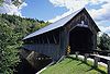 |
1912 | 1976-12-12 | Columbia Columbia, New Hampshire Columbia is a town in Coos County, New Hampshire, United States. The population was 757 at the 2010 census. It is part of the Berlin, NH–VT micropolitan statistical area.-History:... 44°51′12"N 71°33′5"W |
Coos Coos County, New Hampshire -National protected areas:*Umbagog National Wildlife Refuge *Silvio O. Conte National Fish and Wildlife Refuge *White Mountain National Forest -Demographics:... |
Howe truss |
| Coombs Covered Bridge Coombs Covered Bridge Coombs Covered Bridge is a wooden covered bridge over the Ashuelot River in Winchester, New Hampshire.It was built in 1837 and added to the National Register of Historic Places in 1976.-External links:*, NH Division of Historical Resources... |
1837 | 1976-11-21 | Winchester Winchester, New Hampshire Winchester is a town in Cheshire County, New Hampshire, United States. The population was 4,341 at the 2010 census. The primary settlement in the town, where 1,733 people resided at the 2010 census, is defined by the U.S. Census Bureau as the Winchester census-designated place... 42°50′17"N 72°21′43"W |
Cheshire Cheshire County, New Hampshire -Demographics:As of the census of 2000, there were 73,825 people, 28,299 households, and 18,790 families residing in the county. The population density was 104 people per square mile . There were 31,876 housing units at an average density of 45 per square mile... |
Town truss | |
| Cornish-Windsor Covered Bridge Cornish-Windsor Covered Bridge The Cornish–Windsor Covered Bridge is a covered bridge that spans the Connecticut River between Cornish, New Hampshire and Windsor, Vermont. It was the longest covered bridge still standing in the United States until the Smolen–Gulf Bridge opened in Ohio in 2008.While the Old Blenheim Bridge had... |
 |
1866 | 1976-11-21 | Cornish Cornish, New Hampshire Cornish is a town in Sullivan County, New Hampshire, United States. The population was 1,640 at the 2010 census. Cornish has three covered bridges. Each August, it is home to the Cornish Fair.-History:... 43°28′26"N 72°23′1"W |
Sullivan Sullivan County, New Hampshire -Demographics:As of the census of 2000, there were 40,458 people, 16,530 households, and 11,174 families residing in the county. The population density was 29/; . There were 20,158 housing units at an average density of 38 per square mile... |
Town lattice truss |
| County Farm Bridge County Farm Bridge (Wilton, New Hampshire) County Farm Bridge is a historic bridge in Wilton, New Hampshire.The bridge was built in 1885 and added to the National Register of Historic Places in 1981.... |
1885 | 1981-05-14 | Wilton Wilton, New Hampshire - Demographics :As of the census of 2000, there were 3,743 people, 1,410 households, and 1,023 families living in the town. The population density was 145.3 people per square mile . There were 1,451 housing units at an average density of 56.3 per square mile... 42°51′25"N 71°49′3"W |
Hillsborough Hillsborough County, New Hampshire -Demographics:As of the census of 2000, there were 380,841 people, 144,455 households, and 98,807 families residing in the county. The population density was 435 people per square mile . There were 149,961 housing units at an average density of 171 per square mile... |
||
| County Farm Bridge County Farm Bridge (Dover, New Hampshire) County Farm Bridge is a historic bridge over the Cocheco River in Dover, New Hampshire.The bridge was built in 1875 and added to the National Register of Historic Places in 1975. The bridge burned down prior to 1990, but its abutments can still be viewed from a nature trail behind the county jail.... |
1975-05-21 | Dover Dover, New Hampshire Dover is a city in Strafford County, New Hampshire, in the United States of America. The population was 29,987 at the 2010 census, the largest in the New Hampshire Seacoast region... 43°13′14"N 70°56′38"W |
Strafford Strafford County, New Hampshire -Demographics:As of the census of 2000, there were 112,233 people, 42,581 households, and 27,762 families residing in the county. The population density was 304 people per square mile . There were 45,539 housing units at an average density of 124 per square mile... |
Howe Truss | ||
| Dalton Covered Bridge Dalton Covered Bridge The Dalton Covered Bridge, also called the Dalton Bridge, is a historic covered bridge over the Warner River on Joppa Road in Warner, New Hampshire.... |
1853 | 1976-11-21 | Warner Warner, New Hampshire Warner is a town in Merrimack County, New Hampshire, United States. The population was 2,833 at the 2010 census. The town is home to The College of Saint Mary Magdalen, Rollins State Park and Mount Kearsarge State Forest.... 43°16′36"N 71°48′43"W |
Merrimack Merrimack County, New Hampshire -Demographics:As of the census of 2000, there were 136,225 people, 51,843 households, and 35,460 families residing in the county. The population density was 146 people per square mile . There were 56,244 housing units at an average density of 60 per square mile... |
panel truss | |
| Dingleton Hill Covered Bridge | 1882, 1883 | 1978-11-08 | Cornish Mills 43°27′51"N 72°22′9"W |
Sullivan Sullivan County, New Hampshire -Demographics:As of the census of 2000, there were 40,458 people, 16,530 households, and 11,174 families residing in the county. The population density was 29/; . There were 20,158 housing units at an average density of 38 per square mile... |
Kingpost Truss | |
| Durgin Bridge | 1869 | 1983-09-22 | Sandwich Sandwich, New Hampshire Sandwich is a town in Carroll County, New Hampshire, United States. The population was 1,326 at the 2010 census. Sandwich includes the villages of Center Sandwich and North Sandwich... 43°51′21"N 71°21′53"W |
Carroll Carroll County, New Hampshire -Demographics:As of the census of 2000, there were 43,666 people, 18,351 households, and 12,313 families residing in the county. The population density was 18/km² . There were 34,750 housing units at an average density of 14/km²... |
Paddleford truss | |
| Gilsum Stone Arch Bridge | 1863 | 1989-08-31 | Gilsum Gilsum, New Hampshire Gilsum is a town in Cheshire County, New Hampshire, United States. The population was 813 at the 2010 census. Home to the Bear's Den Natural Area, Gilsum includes Gilsum Lower Village.-History:... 43°2′20"N 72°16′14"W |
Cheshire Cheshire County, New Hampshire -Demographics:As of the census of 2000, there were 73,825 people, 28,299 households, and 18,790 families residing in the county. The population density was 104 people per square mile . There were 31,876 housing units at an average density of 45 per square mile... |
Dry Masonry Arch Bridge | |
| Goffstown Covered Railroad Bridge | 1901 | 1975-06-18 | Goffstown Goffstown, New Hampshire Goffstown is a town in Hillsborough County, New Hampshire, United States. The population was 17,651 at the 2010 census. The compact center of town, where 3,196 people resided at the 2010 census, is defined by the U.S. Census Bureau as the Goffstown census-designated place and is located at the... 43°1′4"N 71°35′58"W |
Hillsborough Hillsborough County, New Hampshire -Demographics:As of the census of 2000, there were 380,841 people, 144,455 households, and 98,807 families residing in the county. The population density was 435 people per square mile . There were 149,961 housing units at an average density of 171 per square mile... |
Town-Pratt truss | |
| Great Hollow Road Stone Arch Bridge Great Hollow Road Stone Arch Bridge Great Hollow Road Stone Arch Bridge is a historic bridge on Great Hollow Road, over Mink Brook, approximately 100 feet north of the junction with Smith Lane in Hanover, New Hampshire.... |
1914 | 1997-05-12 | Hanover Hanover, New Hampshire Hanover is a town along the Connecticut River in Grafton County, New Hampshire, United States. The population was 11,260 at the 2010 census. CNN and Money magazine rated Hanover the sixth best place to live in America in 2011, and the second best in 2007.... 43°41′13"N 72°14′0"W |
Grafton Grafton County, New Hampshire Grafton County is a county located in the U.S. state of New Hampshire. As of the 2010 census, the population was 89,118. Its county seat is North Haverhill, which is a village within the town of Haverhill. Until 1972, the county courthouse and other offices were located in downtown Woodsville, a... |
||
| Hancock-Greenfield Bridge Hancock-Greenfield Bridge The Hancock-Greenfield Bridge is a historic covered bridge over the Contoocook River near Hancock, New Hampshire. The New Hampshire Department of Transportation covered bridge database refers to it as County Bridge.... |
1937 | 1981-05-05 | Hancock Hancock, New Hampshire Hancock is a town in Hillsborough County, New Hampshire, United States. The population was 1,654 at the 2010 census. Hancock is home to the Welch Family Farm Forest.... 42°57′25"N 71°56′8"W |
Hillsborough Hillsborough County, New Hampshire -Demographics:As of the census of 2000, there were 380,841 people, 144,455 households, and 98,807 families residing in the county. The population density was 435 people per square mile . There were 149,961 housing units at an average density of 171 per square mile... |
Teco-Pratt timber truss | |
| Haverhill-Bath Covered Bridge Haverhill-Bath Covered Bridge Haverhill-Bath Covered Bridge is a historic covered bridge over the Ammonoosuc River in Woodsville, New Hampshire. Formerly used by New Hampshire Route 135, the bridge was idled in 1999. Restored in 2004, it is now open to foot traffic only.... |
1829 | 1977-04-18 | Woodsville Woodsville, New Hampshire Woodsville is a census-designated place in the town of Haverhill in Grafton County, New Hampshire, U.S., along the Connecticut River at the mouth of the Ammonoosuc River. The population was 1,126 at the 2010 census... 44°9′16"N 72°2′12"W |
Grafton Grafton County, New Hampshire Grafton County is a county located in the U.S. state of New Hampshire. As of the 2010 census, the population was 89,118. Its county seat is North Haverhill, which is a village within the town of Haverhill. Until 1972, the county courthouse and other offices were located in downtown Woodsville, a... |
Town lattice truss | |
| Hillsborough Railroad Bridge | 1903 | 1975-06-10 | Hillsborough Hillsborough, New Hampshire Hillsborough, frequently spelled Hillsboro, is a town in Hillsborough County, New Hampshire, United States. The population was 6,011 at the 2010 census... 43°6′48"N 71°53′44"W |
Hillsborough Hillsborough County, New Hampshire -Demographics:As of the census of 2000, there were 380,841 people, 144,455 households, and 98,807 families residing in the county. The population density was 435 people per square mile . There were 149,961 housing units at an average density of 171 per square mile... |
Town lattice truss | |
| Hopkinton Railroad Covered Bridge | 1849, 1889, 1936 | 1980-01-11 | Contoocook Contoocook, New Hampshire Contoocook is a village and census-designated place within the town of Hopkinton in Merrimack County, New Hampshire, United States. The population was 1,444 at the 2010 census.-History:... 43°13′23"N 71°42′51"W |
Merrimack Merrimack County, New Hampshire -Demographics:As of the census of 2000, there were 136,225 people, 51,843 households, and 35,460 families residing in the county. The population density was 146 people per square mile . There were 56,244 housing units at an average density of 60 per square mile... |
Town Pratt truss; Crosses Contoocook River Contoocook River The Contoocook River is a river in New Hampshire. It flows from Pool Pond and Contoocook Lake on the Jaffrey/Rindge border to Penacook , where it empties into the Merrimack River. It is one of only a few rivers in New Hampshire that flow in a predominantly northward direction... |
|
| Keniston Bridge | 1882 | 1989-03-16 | Andover Andover, New Hampshire Andover is a town in Merrimack County, New Hampshire, United States. The population was 2,371 at the 2010 census. Andover includes the villages of Cilleyville, Potter Place, and East Andover, in addition to the town center... 43°26′6"N 71°50′12"W |
Merrimack Merrimack County, New Hampshire -Demographics:As of the census of 2000, there were 136,225 people, 51,843 households, and 35,460 families residing in the county. The population density was 146 people per square mile . There were 56,244 housing units at an average density of 60 per square mile... |
Town through truss | |
| Kenyon Bridge | 1882 | 1978-05-22 | Cornish City 43°28′0"N 72°21′3"W |
Sullivan Sullivan County, New Hampshire -Demographics:As of the census of 2000, there were 40,458 people, 16,530 households, and 11,174 families residing in the county. The population density was 29/; . There were 20,158 housing units at an average density of 38 per square mile... |
Multiple Kingpost Truss | |
| Meadow Bridge Meadow Bridge (Shelburne, New Hampshire) Meadow Bridge is a historic bridge across the Androscoggin River located on a spur of North Road in Shelburne, New Hampshire.It was built in 1897 and added to the National Register of Historic Places in 2003.... |
1897 | 2003-12-10 | Shelburne Shelburne, New Hampshire Shelburne is a town in Coos County, New Hampshire, United States. The population was 372 at the 2010 census. It is located in the White Mountains, and part of the White Mountain National Forest is in the south. Shelburne is home to Leadmine State Forest... 44°24′5"N 71°3′49"W |
Coos Coos County, New Hampshire -National protected areas:*Umbagog National Wildlife Refuge *Silvio O. Conte National Fish and Wildlife Refuge *White Mountain National Forest -Demographics:... |
Multiple Steel Truss | |
| Meriden Bridge | 1980-08-27 | Meriden Meriden, New Hampshire Meriden is a village in the eastern part of the town of Plainfield in Sullivan County, New Hampshire, United States. Meriden is home to Kimball Union Academy, a private boarding school.... 43°33′12"N 72°16′0"W |
Sullivan Sullivan County, New Hampshire -Demographics:As of the census of 2000, there were 40,458 people, 16,530 households, and 11,174 families residing in the county. The population density was 29/; . There were 20,158 housing units at an average density of 38 per square mile... |
Multiple Kingpost Truss | ||
| Morey Memorial Bridge | 1937 | 1997-12-08 | Orford Orford, New Hampshire Orford is a town in Grafton County, New Hampshire, United States. The population was 1,237 at the 2010 census. The Appalachian Trail crosses in the east.-History:... 43°54′25"N 72°08′22"W |
Grafton Grafton County, New Hampshire Grafton County is a county located in the U.S. state of New Hampshire. As of the 2010 census, the population was 89,118. Its county seat is North Haverhill, which is a village within the town of Haverhill. Until 1972, the county courthouse and other offices were located in downtown Woodsville, a... |
Arch bridge Arch bridge An arch bridge is a bridge with abutments at each end shaped as a curved arch. Arch bridges work by transferring the weight of the bridge and its loads partially into a horizontal thrust restrained by the abutments at either side... |
|
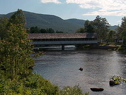
| Mount Orne Covered Bridge Mount Orne Covered Bridge The Mount Orne Bridge is a wooden Howe truss bridge over the Connecticut River located between Lancaster, New Hampshire and Lunenburg, Vermont.- History :... |
 |
1911 | 1976-12-12 | Lancaster Lancaster, New Hampshire Lancaster is a town in Coos County, New Hampshire, USA, on the Connecticut River named after Lancaster, England. As of the 2010 census, the town population was 3,507, the second largest in the county after Berlin. It is the county seat of Coos County and gateway to the Great North Woods Region... 44°27′38"N 71°39′12"W |
Coos Coos County, New Hampshire -National protected areas:*Umbagog National Wildlife Refuge *Silvio O. Conte National Fish and Wildlife Refuge *White Mountain National Forest -Demographics:... |
Howe truss |
| Pier Bridge | 1907 | 1975-06-10 | Newport Newport, New Hampshire Newport is a town in and the county seat of Sullivan County, New Hampshire, United States. It is west-northwest of Concord. The population was 6,507 at the 2010 census. A covered bridge is in the northwest... 43°21′43"N 72°14′31"W |
Sullivan Sullivan County, New Hampshire -Demographics:As of the census of 2000, there were 40,458 people, 16,530 households, and 11,174 families residing in the county. The population density was 29/; . There were 20,158 housing units at an average density of 38 per square mile... |
Town lattice truss | |
| Piermont Bridge | 1928 | 2001-06-06 | Piermont Piermont, New Hampshire Piermont is a town in Grafton County, New Hampshire, United States. The population was 790 at the 2010 census. It is home to several summer camps.-History:... 43°58′40"N 72°6′45"W |
Grafton Grafton County, New Hampshire Grafton County is a county located in the U.S. state of New Hampshire. As of the 2010 census, the population was 89,118. Its county seat is North Haverhill, which is a village within the town of Haverhill. Until 1972, the county courthouse and other offices were located in downtown Woodsville, a... |
Pennsylvania through truss | |
| Pineground Bridge | 1887 | 2004-03-10 | Chichester Chichester, New Hampshire Chichester is a town in Merrimack County, New Hampshire, United States. The population was 2,523 at the 2010 census.-History:Chichester was granted in 1727, named for Thomas Pelham-Holles, 1st Duke of Newcastle-upon-Tyne, Earl of Chichester, and England's Secretary of State for the Southern... 43°15′26"N 71°22′12"W |
Merrimack Merrimack County, New Hampshire -Demographics:As of the census of 2000, there were 136,225 people, 51,843 households, and 35,460 families residing in the county. The population density was 146 people per square mile . There were 56,244 housing units at an average density of 60 per square mile... |
Lenticular Through Truss | |
| Prentiss Bridge | 1973-05-24 | Langdon Langdon, New Hampshire Langdon is a town in Sullivan County, New Hampshire, United States. The population was 688 at the 2010 census.-History:First settled in 1773 by Seth Walker, Langdon was incorporated on January 11, 1787, when it was named after Governor John Langdon. The town is home to the Prentiss Bridge, the... 43°9′11"N 72°23′38"W |
Sullivan Sullivan County, New Hampshire -Demographics:As of the census of 2000, there were 40,458 people, 16,530 households, and 11,174 families residing in the county. The population density was 29/; . There were 20,158 housing units at an average density of 38 per square mile... |
Town lattice truss | ||
| Rowell's Covered Bridge | 1852, 1853 | 1976-11-21 | West Hopkinton 43°11′30"N 71°45′40"W |
Merrimack Merrimack County, New Hampshire -Demographics:As of the census of 2000, there were 136,225 people, 51,843 households, and 35,460 families residing in the county. The population density was 146 people per square mile . There were 56,244 housing units at an average density of 60 per square mile... |
Long patent truss;Burr arch | |
| Samuel Morey Memorial Bridge | 1936, 1938 | 1997-12-08 | Orford Orford, New Hampshire Orford is a town in Grafton County, New Hampshire, United States. The population was 1,237 at the 2010 census. The Appalachian Trail crosses in the east.-History:... 43°54′25"N 72°8′23"W |
Grafton Grafton County, New Hampshire Grafton County is a county located in the U.S. state of New Hampshire. As of the 2010 census, the population was 89,118. Its county seat is North Haverhill, which is a village within the town of Haverhill. Until 1972, the county courthouse and other offices were located in downtown Woodsville, a... |
Steel Arch | |
| Sawyers Crossing Covered Bridge Sawyers Crossing Covered Bridge Sawyers Crossing Covered Bridge is a wooden covered bridge over the Ashuelot River in Swanzey, New Hampshire.It was built in 1859 and added to the National Register of Historic Places in 1978.-External links:*, NH Division of Historical Resources... |
1859 | 1978-11-14 | Swanzey Swanzey, New Hampshire Swanzey is a town in Cheshire County, New Hampshire, United States. The population was 7,230 at the 2010 census. In addition to the town center, Swanzey includes the villages of East Swanzey, West Swanzey, North Swanzey, and Westport.-History:... 42°53′8"N 72°17′0"W |
Cheshire Cheshire County, New Hampshire -Demographics:As of the census of 2000, there were 73,825 people, 28,299 households, and 18,790 families residing in the county. The population density was 104 people per square mile . There were 31,876 housing units at an average density of 45 per square mile... |
Town truss | |
| Slate Covered Bridge Slate Covered Bridge Slate Covered Bridge is a historic wooden covered bridge over the Ashuelot River off NH 10 in Westport, New Hampshire.It was built in 1862 and added to the National Register of Historic Places in 1978.-External links:*, NH Division of Historical Resources... |
1862 | 1978-11-14 | Westport 42°50′51"N 72°20′29"W |
Cheshire Cheshire County, New Hampshire -Demographics:As of the census of 2000, there were 73,825 people, 28,299 households, and 18,790 families residing in the county. The population density was 104 people per square mile . There were 31,876 housing units at an average density of 45 per square mile... |
Town lattice truss | |
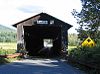
| Stark Covered Bridge Stark Covered Bridge Stark Covered Bridge is a historic wooden covered bridge over the Upper Ammonoosuc River in Stark, New Hampshire.It was built in 1857 and added to the National Register of Historic Places in 1980.-External links:*, NH Division of Historical Resources... |
 |
1980-12-01 | Groveton Groveton, New Hampshire Groveton is a census-designated place in the town of Northumberland in Coos County, New Hampshire, United States. The population was 1,118 at the 2010 census. It is located at the intersection of U.S... 44°36′3"N 71°24′30"W |
Coos Coos County, New Hampshire -National protected areas:*Umbagog National Wildlife Refuge *Silvio O. Conte National Fish and Wildlife Refuge *White Mountain National Forest -Demographics:... |
Paddleford truss | |
| Stone Arch Underpass | 1848 | 1985-09-12 | Lebanon Lebanon, New Hampshire As of the census of 2000, there were 12,568 people, 5,500 households, and 3,178 families residing in the city. The population density was 311.4 people per square mile . There were 5,707 housing units at an average density of 141.4 per square mile... 43°38′3"N 72°18′21"W |
Grafton Grafton County, New Hampshire Grafton County is a county located in the U.S. state of New Hampshire. As of the 2010 census, the population was 89,118. Its county seat is North Haverhill, which is a village within the town of Haverhill. Until 1972, the county courthouse and other offices were located in downtown Woodsville, a... |
||
| Sulphite Railroad Bridge | 1897 | 1975-06-11 | Franklin Franklin, New Hampshire The median income for a household in the city was $34,613, and the median income for a family was $41,698. Males had a median income of $32,318 versus $25,062 for females. The per capita income for the city was $17,155... 43°26′43"N 71°38′10"W |
Merrimack Merrimack County, New Hampshire -Demographics:As of the census of 2000, there were 136,225 people, 51,843 households, and 35,460 families residing in the county. The population density was 146 people per square mile . There were 56,244 housing units at an average density of 60 per square mile... |
Pratt truss | |
| Swiftwater Covered Bridge Swiftwater Covered Bridge Swiftwater Covered Bridge is a historic bridge over the Wild Ammonoosuc River in Bath, New Hampshire.The Paddleford truss bridge was built in 1849 and added to the National Register of Historic Places in 1976.... |
1849 | 1976-11-21 | Bath Bath, New Hampshire Bath is a town in Grafton County, New Hampshire, United States. The population was 1,077 at the 2010 census. Now a tourist destination and bedroom community for Littleton, the town is noted for its historic architecture, including the Brick Store and three covered bridges... 44°8′3"N 71°57′5"W |
Grafton Grafton County, New Hampshire Grafton County is a county located in the U.S. state of New Hampshire. As of the 2010 census, the population was 89,118. Its county seat is North Haverhill, which is a village within the town of Haverhill. Until 1972, the county courthouse and other offices were located in downtown Woodsville, a... |
Paddleford truss | |
| Tilton Island Park Bridge | 1858, 1881 | 1980-03-21 | Tilton Tilton, New Hampshire Tilton is a town located on the Winnipesaukee River in Belknap County, New Hampshire, United States. The population was 3,567 at the 2010 census. It includes the village of Lochmere. Tilton is home to the Tilton School, a private preparatory school.-History:... 43°26′32"N 71°35′13"W |
Belknap Belknap County, New Hampshire -Demographics:As of the census of 2000, there were 56,325 people, 22,459 households, and 15,496 families residing in the county. The population density was 140 people per square mile . There were 32,121 housing units at an average density of 80 per square mile... |
Truesdell Truss | |
| Waterloo Covered Bridge | 1859, 1860 | 1976-11-21 | Waterloo 43°17′16"N 71°51′27"W |
Merrimack Merrimack County, New Hampshire -Demographics:As of the census of 2000, there were 136,225 people, 51,843 households, and 35,460 families residing in the county. The population density was 146 people per square mile . There were 56,244 housing units at an average density of 60 per square mile... |
Town lattice truss | |
| West Swanzey Covered Bridge West Swanzey Covered Bridge West Swanzey Covered Bridge is a historic wooden covered bridge on Main Street over the Ashuelot River in West Swanzey, New Hampshire.... |
1832 | 1980-02-29 | West Swanzey West Swanzey, New Hampshire West Swanzey is a census-designated place in the town of Swanzey within Cheshire County, New Hampshire, United States. The population was 1,308 at the 2010 census.-Geography:West Swanzey is located at .... 42°52′18"N 72°19′42"W |
Cheshire Cheshire County, New Hampshire -Demographics:As of the census of 2000, there were 73,825 people, 28,299 households, and 18,790 families residing in the county. The population density was 104 people per square mile . There were 31,876 housing units at an average density of 45 per square mile... |
Town truss | |
| Whittier Bridge Whittier Bridge Whittier Bridge is a historic wooden covered bridge on Old NH 25 in Ossipee, New Hampshire. It was built in 1870 and added to the National Register of Historic Places in 1984.-External links:*, NH Division of Historical Resources... |
1984-03-15 | Ossipee Ossipee, New Hampshire Ossipee is a town in Carroll County, New Hampshire, United States. The population was 4,345 at the 2010 census. It is the county seat of Carroll County... 43°49′13"N 71°11′59"W |
Carroll Carroll County, New Hampshire -Demographics:As of the census of 2000, there were 43,666 people, 18,351 households, and 12,313 families residing in the county. The population density was 18/km² . There were 34,750 housing units at an average density of 14/km²... |
Paddleford Truss | ||
| Wright's Bridge | 1906 | 1975-06-10 | Newport Newport, New Hampshire Newport is a town in and the county seat of Sullivan County, New Hampshire, United States. It is west-northwest of Concord. The population was 6,507 at the 2010 census. A covered bridge is in the northwest... 43°21′33"N 72°15′34"W |
Sullivan Sullivan County, New Hampshire -Demographics:As of the census of 2000, there were 40,458 people, 16,530 households, and 11,174 families residing in the county. The population density was 29/; . There were 20,158 housing units at an average density of 38 per square mile... |
Town-Lattice Truss | |
| Corbin Covered Bridge | removed 1993-09-02 |
Newport Newport, New Hampshire Newport is a town in and the county seat of Sullivan County, New Hampshire, United States. It is west-northwest of Concord. The population was 6,507 at the 2010 census. A covered bridge is in the northwest... |
Sullivan Sullivan County, New Hampshire -Demographics:As of the census of 2000, there were 40,458 people, 16,530 households, and 11,174 families residing in the county. The population density was 29/; . There were 20,158 housing units at an average density of 38 per square mile... |
Town lattice truss |