

List of bridges on the National Register of Historic Places in Nebraska
Encyclopedia
This is a list of bridge
s and tunnel
s on the National Register of Historic Places
in the U.S. state
of Nebraska
.
Bridge
A bridge is a structure built to span physical obstacles such as a body of water, valley, or road, for the purpose of providing passage over the obstacle...
s and tunnel
Tunnel
A tunnel is an underground passageway, completely enclosed except for openings for egress, commonly at each end.A tunnel may be for foot or vehicular road traffic, for rail traffic, or for a canal. Some tunnels are aqueducts to supply water for consumption or for hydroelectric stations or are sewers...
s on the National Register of Historic Places
National Register of Historic Places
The National Register of Historic Places is the United States government's official list of districts, sites, buildings, structures, and objects deemed worthy of preservation...
in the U.S. state
U.S. state
A U.S. state is any one of the 50 federated states of the United States of America that share sovereignty with the federal government. Because of this shared sovereignty, an American is a citizen both of the federal entity and of his or her state of domicile. Four states use the official title of...
of Nebraska
Nebraska
Nebraska is a state on the Great Plains of the Midwestern United States. The state's capital is Lincoln and its largest city is Omaha, on the Missouri River....
.
| Name | Image | Built | Listed | Location | County | Type |
|---|---|---|---|---|---|---|
| Adamson Bridge | 1916 | 1992-06-29 | Valentine Valentine, Nebraska -Demographics:As of the census of 2000, there were 2,820 people, 1,209 households, and 733 families residing in the city. The population density was 1,401.1 people per square mile . There were 1,373 housing units at an average density of 682.2 per square mile... 42°48′26"N 100°40′20"W |
Cherry Cherry County, Nebraska Cherry County is unusual in being split between two time zones, Mountain Time and Central Time. The lines between the two runs roughly north to south along the eastern third of the county. Cherry County is also the location of the Valentine National Wildlife Refuge, the Fort Niobrara National... |
Timber stringer trestle | |
| Ashland Bridge (Ashland, Nebraska) Ashland Bridge (Ashland, Nebraska) The Ashland Bridge in Ashland, Nebraska is a pony truss bridge that was built in 1936. It was listed on the National Register of Historic Places in 1992.... |
1936 | 1992-06-29 | Ashland Ashland, Nebraska Ashland is a city in Saunders County, Nebraska, United States. The population was 2,262 at the 2000 census.- History :Ashland is located at the site of a low-water limestone ledge along the bottom of Salt Creek, an otherwise mud-bottomed stream that was a formidable obstacle for wagon trains on the... 41°2′4"N 96°22′1"W |
Saunders Saunders County, Nebraska -History:Saunders County was established by an 1856 act of the Nebraska Territorial Legislature; its boundaries were redefined in 1858. The county was originally named after John C... |
Warren pony truss | |
| Beal Slough Bridge | 1937 | 1992-06-29 | Lincoln Lincoln, Nebraska The City of Lincoln is the capital and the second-most populous city of the US state of Nebraska. Lincoln is also the county seat of Lancaster County and the home of the University of Nebraska. Lincoln's 2010 Census population was 258,379.... 40°46′13"N 96°42′46"W |
Lancaster Lancaster County, Nebraska -Demographics:As of the census of 2000, there were 250,291 people, 99,187 households, and 60,702 families residing in the county. The population density was 298 people per square mile . There were 104,217 housing units at an average density of 124 per square mile... |
Concrete rigid frame bridge | |
| Bell Bridge | 1903 | 1992-06-29 | Valentine Valentine, Nebraska -Demographics:As of the census of 2000, there were 2,820 people, 1,209 households, and 733 families residing in the city. The population density was 1,401.1 people per square mile . There were 1,373 housing units at an average density of 682.2 per square mile... 42°53′42"N 100°19′20"W |
Cherry Cherry County, Nebraska Cherry County is unusual in being split between two time zones, Mountain Time and Central Time. The lines between the two runs roughly north to south along the eastern third of the county. Cherry County is also the location of the Valentine National Wildlife Refuge, the Fort Niobrara National... |
Pratt through truss | |
| Berry State Aid Bridge | 1920, 1921 | 1992-06-29 | Valentine Valentine, Nebraska -Demographics:As of the census of 2000, there were 2,820 people, 1,209 households, and 733 families residing in the city. The population density was 1,401.1 people per square mile . There were 1,373 housing units at an average density of 682.2 per square mile... 42°54′7"N 100°21′44"W |
Cherry Cherry County, Nebraska Cherry County is unusual in being split between two time zones, Mountain Time and Central Time. The lines between the two runs roughly north to south along the eastern third of the county. Cherry County is also the location of the Valentine National Wildlife Refuge, the Fort Niobrara National... |
Pratt through truss | |
| Big Blue River Bridge (Surprise, Nebraska) | 1897, 1898 | 1992-06-29 | Surprise Surprise, Nebraska Surprise is a village in Butler County, Nebraska, United States. The population was 44 at the 2000 census.-Geography:Surprise is located at .... 41°6′3"N 97°17′28"W |
Butler Butler County, Nebraska -Demographics:As of the census of 2000, there were 8,767 people, 3,426 households, and 2,350 families residing in the county. The population density was 15 people per square mile . There were 3,901 housing units at an average density of 7 per square mile... |
Pin-connected Pratt truss | |
| Big Blue River Bridge (Grafton, Nebraska) | 1918 | 1992-06-29 | Grafton Grafton, Nebraska Grafton is a village in Fillmore County, Nebraska, United States. The population was 126 at the 2010 census.-Geography:Grafton is located at .... 40°41′47"N 97°43′44"W |
Fillmore Fillmore County, Nebraska -Hunting:Fillmore is popular with hunters of pheasant, deer, Canada goose and other popular game animals.-Organizations:Fillmore County is home to a nonprofit organization which promotes education and the development of habitat for butterflies in Nebraska.... |
Concrete spandrel arch | |
| Big Indian Creek Bridge | 1903 | 1992-06-29 | Wymore Wymore, Nebraska Wymore is a city in Gage County, Nebraska, United States. The population was 1,656 at the 2000 census. Wymore was founded on April 7, 1881 on land donated by Sam Wymore as a railroad town... 40°5′13"N 96°43′22"W |
Gage Gage County, Nebraska -History:Gage County was formed with land taken from the Oto in an 1854 treaty. It was named after the minister William D. Gage.-Demographics:As of the census of 2000, there were 22,993 people, 9,316 households, and 6,204 families residing in the county. The population density was 27 people per... |
Warren pony truss | |
| Big Papillion Creek Bridge | 1992-06-29 | La Vista La Vista, Nebraska La Vista is a city in Sarpy County, Nebraska, United States. The population was 15,758 at the 2010 census. The city was incorporated in 1960 and is the newest city in the state. La Vista is a suburb of Omaha, Nebraska and is one of the fastest growing cities in the state. La Vista is part of the... 41°10′27"N 96°6′1"W |
Sarpy Sarpy County, Nebraska -Demographics:As of the census of 2000, there were 122,595 people, 43,426 households, and 33,220 families residing in the county. The population density was 510 people per square mile . There were 44,981 housing units at an average density of 187 per square mile... |
Tied arch pony truss | ||
| Bloody Run Bridge | 1898 | 1992-06-29 | Virginia Virginia, Nebraska Virginia is a village in Gage County, Nebraska, United States. The population was 67 at the 2000 census.-Geography:Virginia is located at .... 40°12′39"N 96°33′29"W |
Gage Gage County, Nebraska -History:Gage County was formed with land taken from the Oto in an 1854 treaty. It was named after the minister William D. Gage.-Demographics:As of the census of 2000, there were 22,993 people, 9,316 households, and 6,204 families residing in the county. The population density was 27 people per... |
Warren pony truss | |
| Borman Bridge | 1916 | 1992-06-29 | Valentine Valentine, Nebraska -Demographics:As of the census of 2000, there were 2,820 people, 1,209 households, and 733 families residing in the city. The population density was 1,401.1 people per square mile . There were 1,373 housing units at an average density of 682.2 per square mile... 42°51′7"N 100°31′15"W |
Cherry Cherry County, Nebraska Cherry County is unusual in being split between two time zones, Mountain Time and Central Time. The lines between the two runs roughly north to south along the eastern third of the county. Cherry County is also the location of the Valentine National Wildlife Refuge, the Fort Niobrara National... |
Pratt through truss | |
| Brewer Bridge | 1899, 1921 | 1992-06-29 | Valentine Valentine, Nebraska -Demographics:As of the census of 2000, there were 2,820 people, 1,209 households, and 733 families residing in the city. The population density was 1,401.1 people per square mile . There were 1,373 housing units at an average density of 682.2 per square mile... 42°52′34"N 100°15′58"W |
Cherry Cherry County, Nebraska Cherry County is unusual in being split between two time zones, Mountain Time and Central Time. The lines between the two runs roughly north to south along the eastern third of the county. Cherry County is also the location of the Valentine National Wildlife Refuge, the Fort Niobrara National... |
Pratt through truss | |
| Bridge | 1912 | 1992-06-29 | Nebraska City Nebraska City, Nebraska Nebraska City is a city in Otoe County, Nebraska, United States. The population was 7,228 at the 2000 census. It is the county seat of Otoe County... 40°39′39"N 95°52′41"W |
Otoe Otoe County, Nebraska -History:Otoe County was formed in 1854. It was named after the Otoe Indian tribe.-Demographics:As of the census of 2000, there were 15,396 people, 6,060 households, and 4,229 families residing in the county. The population density was 25 people per square mile . There were 6,567 housing units... |
Concrete spandrel arch | |
| Bridge | 1876 | 1992-06-29 | Lorton Lorton, Nebraska Lorton is a village in Otoe County, Nebraska, United States. The population was 39 at the 2000 census.-Geography:Lorton is located at .According to the United States Census Bureau, the village has a total area of , all of it land.... 40°34′1"N 96°5′26"W |
Otoe Otoe County, Nebraska -History:Otoe County was formed in 1854. It was named after the Otoe Indian tribe.-Demographics:As of the census of 2000, there were 15,396 people, 6,060 households, and 4,229 families residing in the county. The population density was 25 people per square mile . There were 6,567 housing units... |
Bowstring pony arch-truss | |
| Bridge | 1911 | 1992-06-29 | Royal Royal, Nebraska Royal is a village in Antelope County, Nebraska, United States. The population was 75 at the 2000 census.-Geography:Royal is located at .According to the United States Census Bureau, the village has a total area of , all of it land.... 42°24′50"N 98°4′2"W |
Antelope Antelope County, Nebraska Antelope County is a county located in the U.S. state of Nebraska, and was formed in 1871. As of 2010, the population estimate was 6,685. Its county seat is Neligh... |
Kingpost pony truss | |
| Bridge | 1992-06-29 | Louisville Louisville, Nebraska Louisville is a city in Cass County, Nebraska, United States. The population was 1,046 at the 2000 census.-Geography:Louisville is located at .... 40°58′22"N 96°4′55"W |
Cass Cass County, Nebraska -Other Geographical notes:Due to its proximity to Cass County, Iowa, and because both of those counties receive most of their broadcasts from Omaha, Nebraska, references to 'Cass County' must be frequently disambiguated, or result in confusion.-Demographics:... |
Warren truss leg bedstead | ||
| Bridge | 1898 | 1992-06-29 | Wymore Wymore, Nebraska Wymore is a city in Gage County, Nebraska, United States. The population was 1,656 at the 2000 census. Wymore was founded on April 7, 1881 on land donated by Sam Wymore as a railroad town... 40°9′6"N 96°47′3"W |
Gage Gage County, Nebraska -History:Gage County was formed with land taken from the Oto in an 1854 treaty. It was named after the minister William D. Gage.-Demographics:As of the census of 2000, there were 22,993 people, 9,316 households, and 6,204 families residing in the county. The population density was 27 people per... |
Warren pony truss | |
| Bridge | 1908 | 1992-06-29 | Stratton Stratton, Nebraska Stratton is a village in Hitchcock County, Nebraska, United States. The population was 396 at the 2000 census.-Geography:Stratton is located at .... 40°9′7"N 101°11′29"W |
Hitchcock Hitchcock County, Nebraska -History:Hitchcock County was formed in 1873. It was named after the US Senator Phineas Warren Hitchcock.-Demographics:As of the census of 2000, there were 3,111 people, 1,287 households, and 899 families residing in the county. The population density was 4 people per square mile . There were... |
Reinforced concrete slab | |
| Brownson Viaduct | 1942 | 1992-06-29 | Brownson 41°11′22"N 103°7′17"W |
Cheyenne Cheyenne County, Nebraska -History:Cheyenne County was formed in 1871. It was named after the Cheyenne Native American tribe.-Demographics:As of the census of 2000, of 2000, there were 9,830 people, 4,071 households, and 2,686 families residing in the county. The population density was 8 people per square mile . There... |
Timber stringer trestle | |
| Brownville Bridge |  |
1939 | 1993-06-17 | Brownville Brownville, Nebraska Brownville is a village in Nemaha County, Nebraska, United States. The population was 146 at the 2000 census.- History :Established in 1854 and incorporated in 1856, Brownville was the largest town in the Nebraska Territory, with a population of 1,309 by 1880. Bordering slave-holding Missouri, the... 40°23′57"N 95°39′6"W |
Nemaha Nemaha County, Nebraska -Demographics:As of the census of 2000, there were 7,576 people, 3,047 households, and 1,980 families residing in the county. The population density was 18 people per square mile . There were 3,439 housing units at an average density of 8 per square mile... |
|
| Bryan Bridge | 1932 | 1988-06-23 | Valentine Valentine, Nebraska -Demographics:As of the census of 2000, there were 2,820 people, 1,209 households, and 733 families residing in the city. The population density was 1,401.1 people per square mile . There were 1,373 housing units at an average density of 682.2 per square mile... 42°49′56"N 100°31′41"W |
Cherry Cherry County, Nebraska Cherry County is unusual in being split between two time zones, Mountain Time and Central Time. The lines between the two runs roughly north to south along the eastern third of the county. Cherry County is also the location of the Valentine National Wildlife Refuge, the Fort Niobrara National... |
Pin-connected arch bridge | |
| Burwell Bridge | 1940, 1941 | 1992-06-29 | Burwell Burwell, Nebraska Burwell is a city in Garfield County, Nebraska, United States. The population was 1,130 at the 2000 census. It is the county seat of Garfield County.-History:Burwell is host to 'Nebraska's Big Rodeo,' an annual event usually held the last weekend of July... 41°46′4"N 99°7′31"W |
Garfield Garfield County, Nebraska -Demographics:As of the census of 2000, there were 1,902 people, 813 households, and 529 families residing in the county. The population density was 3 people per square mile . There were 1,021 housing units at an average density of 2 per square mile... |
Steel stringer bridge | |
| Cambridge State Aid Bridge | 1914 | 1992-06-29 | Cambridge Cambridge, Nebraska Cambridge is a city in Furnas County, Nebraska, United States. The population was 1,041 at the 2000 census.-Geography:According to the United States Census Bureau, Cambridge has a total area of , all of it land.-Demographics:... 40°16′25"N 100°9′56"W |
Furnas Furnas County, Nebraska -Demographics:As of the census of 2000, there were 5,324 people, 2,278 households, and 1,489 families residing in the county. The population density was 7 people per square mile . There were 2,730 housing units at an average density of 4 per square mile... |
Spandrel arch bridge | |
| Camp Clarke Bridge Site | 1875, 1880 | 1974-11-08 | Bridgeport Bridgeport, Nebraska Bridgeport is a city in Morrill County, Nebraska, United States. The population was 1,594 at the 2000 census. It is the county seat of Morrill County.-Geography:Bridgeport is located at .... |
Morrill Morrill County, Nebraska -History:Morrill County was formed in 1908 "carved out of Cheyenne County". It was named after Charles Henry Morrill, a president of the Lincoln Land Company.-Demographics:... |
||
| Carns State Aid Bridge | 1912, 1913 | 1992-06-29 | Bassett Bassett, Nebraska Bassett is a city in Rock County, Nebraska, United States. The population was 743 at the 2000 census. It is the county seat of Rock County.-Geography:Bassett is located at .... 42°44′1"N 99°28′52"W |
Rock Rock County, Nebraska -National protected areas:* John and Louise Seier National Wildlife Refuge* Niobrara National Scenic River -Demographics:As of the census of 2000, there were 1,756 people, 763 households, and 501 families residing in the county. The population density was 2 people per square mile . There were 935... |
Parker & Pratt through truss | |
| Cincinnati Bridge | 1879, 1880 | 1992-06-29 | Du Bois Du Bois, Nebraska Du Bois is a village in the southeast corner of Pawnee County, Nebraska, United States. The population was 166 at the 2000 census.-Geography:Du Bois is located at .... 40°0′47"N 96°2′40"W |
Pawnee Pawnee County, Nebraska -Demographics:As of the census of 2000, there were 3,087 people, 1,339 households, and 850 families residing in the county. The population density was 7 people per square mile . There were 1,587 housing units at an average density of 4 per square mile... |
Bowstring through arch truss | |
| Clear Creek Bridge | 1891, 1928 | 1992-06-29 | Bellwood Bellwood, Nebraska Bellwood is a village in Butler County, Nebraska, United States. The population was 446 at the 2000 census.-Geography:Bellwood is located at .... 41°23′3"N 97°20′6"W |
Butler Butler County, Nebraska -Demographics:As of the census of 2000, there were 8,767 people, 3,426 households, and 2,350 families residing in the county. The population density was 15 people per square mile . There were 3,901 housing units at an average density of 7 per square mile... |
Warren through truss | |
| Colclesser Bridge | 1888, 1933, 1934 | 1992-06-29 | Rushville Rushville, Nebraska Rushville is a city in Sheridan County, Nebraska, United States. The population was 890 at the 2010 census. It is the county seat of Sheridan County.-Geography:Rushville is located at .... 42°33′3"N 102°29′9"W |
Sheridan Sheridan County, Nebraska -History:Sheridan County was formed in 1885. It was named after General Philip H. Sheridan.-Demographics:As of the census of 2000, there were 6,198 people, 2,549 households, and 1,728 families residing in the county. The population density was 2 people per square mile . There were 3,013 housing... |
Baltimore through truss | |
| Columbus Loup River Bridge | 1932, 1933 | 1992-06-29 | Columbus Columbus, Nebraska Columbus is a city in east central Nebraska, United States. Its population was 22,111 at the 2010 census. It is the county seat of Platte County.-Pre-settlement history:... 41°25′1"N 97°22′4"W |
Platte Platte County, Nebraska -Demographics:As of the census of 2000, there were 31,662 people, 12,076 households, and 8,465 families residing in the county. The population density was 47 people per square mile . There were 12,916 housing units at an average density of 19 per square mile... |
Parker through truss | |
| Deering Bridge | 1916 | 1992-06-29 | Sutton Sutton, Nebraska Sutton is a city in Clay County, Nebraska, United States. The population was 1,447 at the 2000 census. It is part of the Hastings, Nebraska Micropolitan Statistical Area.-Geography:Sutton is located at .... 40°38′26"N 97°49′27"W |
Clay Clay County, Nebraska -Demographics:As of the census of 2000, there were 7,039 people, 2,756 households, and 1,981 families residing in the county. The population density was 12 people per square mile . There were 3,066 housing units at an average density of 5 per square mile... Fillmore Fillmore County, Nebraska -Hunting:Fillmore is popular with hunters of pheasant, deer, Canada goose and other popular game animals.-Organizations:Fillmore County is home to a nonprofit organization which promotes education and the development of habitat for butterflies in Nebraska.... |
Concrete spandrel arch | |
| DeWitt Flour Mills and King Iron Bridge | 1978-12-27 | DeWitt | Gage Gage County, Nebraska -History:Gage County was formed with land taken from the Oto in an 1854 treaty. It was named after the minister William D. Gage.-Demographics:As of the census of 2000, there were 22,993 people, 9,316 households, and 6,204 families residing in the county. The population density was 27 people per... |
Pratt Through Truss | ||
| Elkhorn River Bridge | 1883, 1929 | 1992-06-29 | Clearwater Clearwater, Nebraska Clearwater is a village in Antelope County, Nebraska, United States. The population was 384 at the 2000 census.-Geography:Clearwater is located at .... 42°9′36"N 98°7′33"W |
Antelope Antelope County, Nebraska Antelope County is a county located in the U.S. state of Nebraska, and was formed in 1871. As of 2010, the population estimate was 6,685. Its county seat is Neligh... |
Bowstring through arch-truss | |
| Franklin Bridge Franklin Bridge (Nebraska) Franklin Bridge is a bridge listed on the National Register of Historic Places in Franklin County, Nebraska. The road bridge was built over the Republican River in 1932 and features Warren pony trusses. In 1935, a flood swept away one truss and one approach span.... |
1932, 1935 | 1992-06-29 | Franklin Franklin, Nebraska Franklin is a city in Franklin County, Nebraska, United States. The population was 1,026 at the 2000 census. It is the county seat of Franklin County.-Geography:Franklin is located at .... 40°4′33"N 98°57′8"W |
Franklin Franklin County, Nebraska -Demographics:As of the census of 2000, there were 3,574 people, 1,485 households, and 1,021 families residing in the county. The population density was 6 people per square mile . There were 1,746 housing units at an average density of 3 per square mile... |
Warren pony truss | |
| Gross State Aid Bridge | 1918 | 1992-06-29 | Verdigre Verdigre, Nebraska Verdigre is a village in Knox County, Nebraska, United States. The population was 519 at the 2000 census.-Geography:Verdigre is located at .... 42°39′16"N 98°2′34"W |
Knox Knox County, Nebraska -History:The Lewis and Clark Expedition passed through the area on 4 September 1804.The US Treaty with the Ponca tribe was signed at White Paint Creek on 9 June 1825.Knox County was formed in 1854. It was named after Major General Henry Knox.-Demographics:... |
Parker through truss | |
| Henry State Aid Bridges | 1919 | 1992-06-29 | Henry Henry, Nebraska Henry is a village in Scotts Bluff County, Nebraska, United States. It is part of the Scottsbluff, Nebraska Micropolitan Statistical Area. The population was 162 at the 2000 census.-Geography:Henry is located at .... 41°59′50"N 104°2′50"W |
Scotts Bluff Scotts Bluff County, Nebraska -National protected area:* North Platte National Wildlife Refuge* Scotts Bluff National Monument-Demographics:As of the census of 2000, there were 36,951 people, 14,887 households, and 10,167 families residing in the county. The population density was 50 people per square mile . There were 16,119... |
Concrete spandrel arch | |
| Hoyt Street Bridge | 1992-06-29 | Beatrice Beatrice, Nebraska Beatrice is a city in and the county seat of Gage County, Nebraska.Beatrice is located south of Lincoln on the Big Blue River. It is surrounded by agricultural country. The population was 12,459 at the 2010 census.-History:... 40°16′39"N 96°46′40"W |
Gage Gage County, Nebraska -History:Gage County was formed with land taken from the Oto in an 1854 treaty. It was named after the minister William D. Gage.-Demographics:As of the census of 2000, there were 22,993 people, 9,316 households, and 6,204 families residing in the county. The population density was 27 people per... |
Bowstring through arch-truss | ||
| Interstate Canal Bridge | 1992-06-29 | Scottsbluff Scottsbluff, Nebraska Scottsbluff is a city in Scotts Bluff County, Nebraska, United States. The population was 15,039 at the 2010 census. Scottsbluff is the largest city in the Nebraska Panhandle, and the 13th largest city in Nebraska.... 41°59′50"N 103°38′18"W |
Scotts Bluff Scotts Bluff County, Nebraska -National protected area:* North Platte National Wildlife Refuge* Scotts Bluff National Monument-Demographics:As of the census of 2000, there were 36,951 people, 14,887 households, and 10,167 families residing in the county. The population density was 50 people per square mile . There were 16,119... |
Pratt pony truss | ||
| Keim Stone Arch Bridge | 1916 | 1992-06-29 | Tecumseh Tecumseh, Nebraska Tecumseh is a city in and the county seat of Johnson County, Nebraska, United States. The population was 1,716 at the 2000 census.-Geography:Tecumseh is located at .... 40°23′32"N 96°7′22"W |
Johnson Johnson County, Nebraska -History:Johnson County was formed in 1855. It was named after Vice President Richard M. Johnson.-Demographics:As of the census of 2000, there were 4,488 people, 1,887 households, and 1,254 families residing in the county. The population density was 12 people per square mile . There were 2,116... |
Limestone arch | |
| Kilgore Bridge | 1915 | 1992-06-29 | Kearney Kearney, Nebraska Kearney is a city in and the county seat of Buffalo County, Nebraska, United States. The population was 30,787 at the 2010 census. It is home to the University of Nebraska-Kearney.... 40°41′2"N 98°57′3"W |
Buffalo Buffalo County, Nebraska -Demographics:As of the census of 2000, there were 42,259 people, 15,930 households, and 10,227 families residing in the county. The population density was 44 people per square mile . There were 16,830 housing units at an average density of 17 per square mile... |
Pratt pony truss | |
| Lewellen State Aid Bridge | 1926, 1927 | 1992-06-29 | Lewellen Lewellen, Nebraska Lewellen is a village in Garden County, Nebraska, United States. The population was 282 at the 2000 census.-Geography:Lewellen is located at .According to the United States Census Bureau, the village has a total area of , all land.... 41°19′3"N 102°8′34"W |
Garden Garden County, Nebraska -History:Garden County was formed in 1909 by popular vote. Voters in the general election of November 2, 1909, approved making the northern part of Deuel County into its own county... |
Pratt pony truss | |
| Lewis Bridge | 1922 | 1992-06-29 | Springview Springview, Nebraska Springview is a village in, and the county seat of, Keya Paha County, Nebraska. The population was 244 at the 2000 census.-Geography:Springview is located at .... 42°59′53"N 99°38′8"W |
Keya Paha Keya Paha County, Nebraska -Demographics:As of the census of 2000, there were 983 people, 409 households, and 292 families residing in the county. The population density was 1 people per square mile . There were 548 housing units at an average density of 1 per square mile . The racial makeup of the county was 99.39%... |
Pratt pony truss | |
| Lisco State Aid Bridge Lisco State Aid Bridge The Lisco State Aid Bridge is located on a county road over the North Platte River south of Lisco, Nebraska. Completed in 1928, the bridge today "is distinguished as an important crossing of the Platte River and one of the last two intact multiple-span state aid truss bridges" in... |
1927, 1928 | 1992-06-29 | Lisco 41°29′22"N 102°37′30"W |
Garden Garden County, Nebraska -History:Garden County was formed in 1909 by popular vote. Voters in the general election of November 2, 1909, approved making the northern part of Deuel County into its own county... |
Pratt pony truss | |
| Little Nemaha River Bridge (Syracuse, Nebraska) | 1901 | 1992-06-29 | Syracuse Syracuse, Nebraska Syracuse is a city in Otoe County, Nebraska, United States. The population was 1,762 at the 2000 census.-Geography:Syracuse is located at .According to the United States Census Bureau, the city has a total area of , all of it land.... 40°40′0"N 96°14′9"W |
Otoe Otoe County, Nebraska -History:Otoe County was formed in 1854. It was named after the Otoe Indian tribe.-Demographics:As of the census of 2000, there were 15,396 people, 6,060 households, and 4,229 families residing in the county. The population density was 25 people per square mile . There were 6,567 housing units... |
Pratt pony truss | |
| Little Nemaha River Bridge (Dunbar, Nebraska) | 1874 | 1992-06-29 | Dunbar Dunbar, Nebraska Dunbar is a village in Otoe County, Nebraska, United States. The population was 237 at the 2000 census.-Geography:Dunbar is located at .According to the United States Census Bureau, the village has a total area of , all of it land.... 40°40′57"N 96°2′42"W |
Otoe Otoe County, Nebraska -History:Otoe County was formed in 1854. It was named after the Otoe Indian tribe.-Demographics:As of the census of 2000, there were 15,396 people, 6,060 households, and 4,229 families residing in the county. The population density was 25 people per square mile . There were 6,567 housing units... |
Bowstring pony arch-truss | |
| Loosveldt Bridge | 1888, 1933, 1934 | 1992-06-29 | Rushville Rushville, Nebraska Rushville is a city in Sheridan County, Nebraska, United States. The population was 890 at the 2010 census. It is the county seat of Sheridan County.-Geography:Rushville is located at .... 42°34′53"N 102°23′2"W |
Sheridan Sheridan County, Nebraska -History:Sheridan County was formed in 1885. It was named after General Philip H. Sheridan.-Demographics:As of the census of 2000, there were 6,198 people, 2,549 households, and 1,728 families residing in the county. The population density was 2 people per square mile . There were 3,013 housing... |
Baltimore through truss | |
| Main Street Bridge | 1915, 1920 | 1992-06-29 | Elkhorn Elkhorn, Nebraska Elkhorn was a city in Douglas County, Nebraska, United States and is a present-day neighborhood on the western edge of Omaha. The population was 6,062 at the 2000 census and was estimated by the Census Bureau at 8,192 in 2005... 41°16′54"N 96°14′14"W |
Douglas Douglas County, Nebraska -Demographics:As of the census of 2000, there were 463,585 people, 182,194 households, and 115,146 families residing in the county. The population density was 1,401 people per square mile . There were 192,672 housing units at an average density of 582 per square mile... |
Steel stringer bridge | |
| Meridian Bridge | 1924 | 1993-06-17 | South Yankton 42°51′35"N 97°23′37"W |
Cedar Cedar County, Nebraska -History:Cedar County was formed in 1855. It was named for the great number of cedars that grow there.-Demographics:As of the census of 2000, there were 9,615 people, 3,623 households, and 2,565 families residing in the county. The population density was 13 people per square mile . There were... |
Prat vertical-lift truss | |
| Mission Creek Bridge | 1898 | 1992-06-29 | Barneston Barneston, Nebraska Barneston is a village in Gage County, Nebraska, United States. The population was 122 at the 2000 census. The present-day town of Barneston was settled at the site of one of the largest Oto villages in the 19th century. The agency and a trading post were located there... 40°0′15"N 96°27′48"W |
Gage Gage County, Nebraska -History:Gage County was formed with land taken from the Oto in an 1854 treaty. It was named after the minister William D. Gage.-Demographics:As of the census of 2000, there were 22,993 people, 9,316 households, and 6,204 families residing in the county. The population density was 27 people per... |
Warren pony truss | |
| Neligh Mill Bridge | 1910 | 1992-06-29 | Neligh Neligh, Nebraska Neligh is a city in Antelope County, Nebraska, United States. The population was 1,651 at the 2000 census. It is the county seat of Antelope County. The city's name is pronounced .-History:... 42°7′32"N 98°1′51"W |
Antelope Antelope County, Nebraska Antelope County is a county located in the U.S. state of Nebraska, and was formed in 1871. As of 2010, the population estimate was 6,685. Its county seat is Neligh... |
Pratt through truss | |
| Nine Bridges Bridge | 1913 | 1992-06-29 | Doniphan Doniphan, Nebraska Doniphan is a village in Hall County, Nebraska, United States. The population was 763 at the 2000 census. It is part of the Grand Island, Nebraska Micropolitan Statistical Area. The town of Doniphan was platted by local pioneer William J. Burger in 1879 as a midway point between Hastings and Grand... 40°49′40"N 98°22′47"W |
Hall Hall County, Nebraska -History:Hall County was formed in 1858. It was named after Augustus Hall, an early judge of this territory.- Demographics :As of the census of 2000, there were 53,534 people, 20,356 households, and 14,086 families residing in the county. The population density was 98 people per square mile... |
Pratt half-hip pony truss | |
| Niobrara River Bridge | 1929 | 1992-11-12 | Niobrara Niobrara, Nebraska Niobrara is a village in Knox County, Nebraska, United States. The population was 370 at the 2010 census.-Geography:Niobrara is located at .... 42°45′53"N 98°2′39"W |
Knox Knox County, Nebraska -History:The Lewis and Clark Expedition passed through the area on 4 September 1804.The US Treaty with the Ponca tribe was signed at White Paint Creek on 9 June 1825.Knox County was formed in 1854. It was named after Major General Henry Knox.-Demographics:... |
Warren through truss | |
| North Loup Bridge | 1912 | 1992-06-29 | North Loup North Loup, Nebraska North Loup is a village in Valley County, Nebraska, United States. The population was 339 at the 2000 census.-History:In 1871, a party of Seventh Day Baptists from Wisconsin explored Valley County for settlement sites. In May 1872, they established a community near what is now North Loup... 41°30′38"N 98°45′4"W |
Valley Valley County, Nebraska -Demographics:As of the census of 2000, there were 4,647 people, 1,965 households, and 1,298 families residing in the county. The population density was 8 people per square mile . There were 2,273 housing units at an average density of 4 per square mile... |
Pratt through truss | |
| North Omaha Creek Bridge | 1992-06-29 | Winnebago Winnebago, Nebraska Winnebago is a village in Thurston County, Nebraska, United States. The population was 768 at the 2000 census.-Geography:Winnebago is located at... 42°11′38"N 96°31′50"W |
Thurston Thurston County, Nebraska -History:Varying cultures of indigenous peoples lived along the rivers for thousands of years before European encounter.Thurston County was organized by European Americans in 1889 from land that had been divided between Dakota and Burt counties since the dissolution of Blackbird County in 1879. It... |
Pin-connected Pratt truss | ||
| Olive Branch Bridge | 1897 | 1992-06-29 | Sprague Sprague, Nebraska Sprague is a village in Lancaster County, Nebraska, United States. It is part of the Lincoln, Nebraska Metropolitan Statistical Area. The population was 146 at the 2000 census.-Geography:Sprague is located at .... 40°36′37"N 96°46′27"W |
Lancaster Lancaster County, Nebraska -Demographics:As of the census of 2000, there were 250,291 people, 99,187 households, and 60,702 families residing in the county. The population density was 298 people per square mile . There were 104,217 housing units at an average density of 124 per square mile... |
Warren truss leg bedstead | |
| Plattsmouth Bridge Plattsmouth Bridge . At the time it was the only bridge that was still open crossing the river for more than 100 miles from Omaha to St. Joseph, Missouri]]The Plattsmouth Bridge is a truss bridge over the Missouri River connecting Cass County, Nebraska and Mills County, Iowa via U.S. Route 34... |
 |
1929 | 1993-04-15 | Plattsmouth Plattsmouth, Nebraska Plattsmouth is a city in and the county seat of Cass County, Nebraska, United States, which was founded in 1855. The population was 6,887 at the 2000 census.-History:... 41°0′2"N 95°51′58"W |
Cass Cass County, Nebraska -Other Geographical notes:Due to its proximity to Cass County, Iowa, and because both of those counties receive most of their broadcasts from Omaha, Nebraska, references to 'Cass County' must be frequently disambiguated, or result in confusion.-Demographics:... |
Cantlevered through truss |
| Ponca Creek Bridge | 1904 | 1992-06-29 | Lynch Lynch, Nebraska Lynch is a village in Boyd County, Nebraska, United States. The population was 269 at the 2000 census. Lynch is located in northern Nebraska, between the Missouri and Niobrara Rivers.-Geography:Lynch is located at .... 42°49′27"N 98°24′24"W |
Boyd Boyd County, Nebraska Boyd County is a county located in the U.S. state of Nebraska. As of 2010, the population is 2,099. Its county seat is Butte.In the Nebraska license plate system, Boyd County is represented by the prefix 63 .-Geography:According to the U.S... |
Pratt half-hip pony truss | |
| Prairie Dog Creek Bridge | 1913 | 1992-06-29 | Orleans Orleans, Nebraska Orleans is a village in Harlan County, Nebraska, United States. The population was 425 at the 2000 census.-Geography:Orleans is located at .... 40°0′16"N 99°28′48"W |
Harlan Harlan County, Nebraska -History:Prior to 1870, the portion of the Republican valley that now includes Harlan County was a prized hunting ground for the Native Americans; and the threat of attack deterred white settlement in the area... |
Camelback pony truss | |
| Rattlesnake Creek Bridge | 1903 | 1992-06-29 | Bancroft Bancroft, Nebraska Bancroft is a village in Cuming County, Nebraska, United States. The population was 520 at the 2000 census.John Neihardt, who later became Nebraska's poet laureate, lived in Bancroft for twenty years and wrote many of his works there. His study is preserved at the John G... 42°2′39"N 96°36′48"W |
Cuming Cuming County, Nebraska -History:Cuming County was formed in 1855. It was named after Thomas B. Cuming, an early governor of this territory.-Demographics:As of the census of 2000, there were 10,203 people, 3,945 households, and 2,757 families residing in the county. The population density was 18 people per square mile... |
Pratt half-hip pony truss | |
| Red Cloud Bridge | 1935 | 1992-06-29 | Red Cloud Red Cloud, Nebraska Red Cloud is a city in and the county seat of Webster County, Nebraska, United States. The population was 1,131 at the 2000 census.-History:The region of present-day Red Cloud was intermittently occupied and used as hunting grounds by the Pawnees until 1833. In that year, a treaty was signed in... 40°3′46"N 98°31′7"W |
Webster Webster County, Nebraska -History:Webster County was formed in 1871. It was named after the statesman Daniel Webster.-Demographics:As of the census of 2000, there were 4,061 people, 1,708 households, and 1,118 families residing in the county. The population density was 7 people per square mile . There were 1,972 housing... |
Warren pony/through truss | |
| Republican River Bridge | 1911 | 1992-06-29 | Riverton Riverton, Nebraska Riverton is a village in Franklin County, Nebraska, United States. The population was 145 at the 2000 census.-Geography:Riverton is located at .... 40°4′10"N 98°44′38"W |
Franklin Franklin County, Nebraska -Demographics:As of the census of 2000, there were 3,574 people, 1,485 households, and 1,021 families residing in the county. The population density was 6 people per square mile . There were 1,746 housing units at an average density of 3 per square mile... |
Pratt through truss | |
| Roscoe State Aid Bridge | 1934, 1935 | 1992-06-29 | Roscoe Roscoe, Nebraska Roscoe is an unincorporated community in Keith County, Nebraska, United States. Its altitude is 3,173 feet .... 41°7′33"N 101°34′35"W |
Keith Keith County, Nebraska -History:Keith County was formed in 1873. It was named after Morrill C. Keith, the grandfather of Governor Keith Neville.-Demographics:As of the census of 2000, there were 8,875 people, 3,707 households, and 2,535 families residing in the county. The population density was 8 people per square mile... |
Steel cantilevered stringer | |
| Rulo Bridge |  |
1938, 1939 | 1993-01-04 | Rulo Rulo, Nebraska -History:The 'Leary' excavation is the main 'Oneota'- reference to the Missouri River. The Oneota were a 'Mississippi' equal culture that flourished from 1000 to 1650 AD. Oneota are the ancestors of Siouane-speaking tribes. The site is located near present Rulo. Around 1640, the area around the... 40°3′14"N 95°25′14"W |
Richardson Richardson County, Nebraska -Demographics:As of the census of 2000, there were 9,531 people, 3,993 households, and 2,567 families residing in the county. The population density was 17 people per square mile . There were 4,560 housing units at an average density of 8 per square mile... |
Pennsylvania through truss |
| Saddle Creek Underpass Saddle Creek Underpass The Saddle Creek Underpass is located in the Midtown area of Omaha, Nebraska. Built to accommodate Dodge Street traversing over Saddle Creek Road, the underpass was constructed in 1934 by the Works Progress Administration... |
1934 | 1992-06-29 | Omaha Omaha, Nebraska Omaha is the largest city in the state of Nebraska, United States, and is the county seat of Douglas County. It is located in the Midwestern United States on the Missouri River, about 20 miles north of the mouth of the Platte River... 41°15′35"N 95°58′49"W |
Douglas Douglas County, Nebraska -Demographics:As of the census of 2000, there were 463,585 people, 182,194 households, and 115,146 families residing in the county. The population density was 1,401 people per square mile . There were 192,672 housing units at an average density of 582 per square mile... |
Concrete rigid frame bridge | |
| Sappa Creek Bridge | 1916 | 1992-06-29 | Stamford Stamford, Nebraska Stamford is a village in Harlan County, Nebraska, United States. The population was 202 at the 2000 census.-History:Stamford, named after Stamford, Connecticut, was laid out by the Lincoln Land Company in 1887, becoming incorporated as a village in 1907. The first town board members were Frank... 40°7′53"N 99°33′17"W |
Harlan Harlan County, Nebraska -History:Prior to 1870, the portion of the Republican valley that now includes Harlan County was a prized hunting ground for the Native Americans; and the threat of attack deterred white settlement in the area... |
Pratt pony truss | |
| Sargent Bridge | 1908 | 1992-06-29 | Sargent Sargent, Nebraska Sargent is a city in Custer County, Nebraska, United States. The population was 649 at the 2000 census. The name was chosen by an early postal official to honor close friends.- History :The community was laid out in 1883.... 41°37′38"N 99°22′18"W |
Custer Custer County, Nebraska -History:Custer County was formed in 1877. It was named after General George Armstrong Custer, who was killed at the Battle of Little Bighorn.-Demographics:... |
Pratt through truss | |
| South Omaha Bridge | 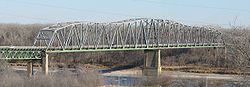 |
1933–1935 | 1992-06-29 | Omaha Omaha, Nebraska Omaha is the largest city in the state of Nebraska, United States, and is the county seat of Douglas County. It is located in the Midwestern United States on the Missouri River, about 20 miles north of the mouth of the Platte River... 41°12′47"N 95°55′57"W |
Douglas Douglas County, Nebraska -Demographics:As of the census of 2000, there were 463,585 people, 182,194 households, and 115,146 families residing in the county. The population density was 1,401 people per square mile . There were 192,672 housing units at an average density of 582 per square mile... |
Warren through truss |
| Stewart Bridge | 1915 | 1992-06-29 | Oak Oak, Nebraska Oak is a village in Nuckolls County, Nebraska, United States. The population was 60 at the 2000 census.-Geography:Oak is located at .According to the United States Census Bureau, the village has a total area of , all of it land.... 40°21′2"N 97°52′38"W |
Nuckolls Nuckolls County, Nebraska Nuckolls County is a county located in the U.S. state of Nebraska. As of the 2010 census, the county population was 4,500. Its county seat is Nelson.... |
Concrete spandrel arch | |
| Sutherland State Aid Bridge | 1914, 1915 | 1992-06-29 | Sutherland Sutherland, Nebraska Sutherland is a village in Lincoln County, Nebraska, United States. It is part of the North Platte, Nebraska Micropolitan Statistical Area. The population was 1,129 at the 2000 census.-Geography:Sutherland is located at .... 41°12′41"N 100°59′51"W |
Lincoln Lincoln County, Nebraska -Demographics:As of the census of 2000, there were 34,632 people, 14,076 households, and 9,444 families residing in the county. The population density was 14 people per square mile . There are 15,438 housing units in Lincoln.... |
Concrete spandrel arch | |
| Sweetwater Mill Bridge | 1909 | 1992-06-29 | Sweetwater Sweetwater, Nebraska Sweetwater is an unincorporated community in Beaver Township, Buffalo County, Nebraska, United States. It lies along Nebraska Highway 2, half way between Ravenna and Hazard. It is a part of the Kearney, Nebraska Micropolitan Statistical Area. Sweetwater is located on Mud Creek, a tributary of... 41°2′27"N 99°0′27"W |
Buffalo Buffalo County, Nebraska -Demographics:As of the census of 2000, there were 42,259 people, 15,930 households, and 10,227 families residing in the county. The population density was 44 people per square mile . There were 16,830 housing units at an average density of 17 per square mile... |
Pratt pony truss | |
| Tekamah City Bridge | 1934 | 1992-06-29 | Tekamah Tekamah, Nebraska Tekamah is a city in Burt County, Nebraska, United States. The population was 1,736 at the 2010 census. It is the county seat of Burt County.-History:... 41°46′36"N 96°13′15"W |
Burt Burt County, Nebraska -History:Burt County was formed in 1854. It was named after Francis Burt, the first governor of Nebraska Territory.-Demographics:As of the census of 2000, there were 7,791 people, 3,155 households, and 2,240 families residing in the county. The population density was 16 people per square mile . ... |
Concrete rigid frame bridge | |
| Turkey Creek Bridge | 1899 | 1992-06-29 | Ragan Ragan, Nebraska Ragan is a village in Harlan County, Nebraska, United States. The population was 46 at the 2000 census.-Geography:Ragan is located at .According to the United States Census Bureau, the village has a total area of , all of it land.... 40°17′33"N 99°19′57"W |
Harlan Harlan County, Nebraska -History:Prior to 1870, the portion of the Republican valley that now includes Harlan County was a prized hunting ground for the Native Americans; and the threat of attack deterred white settlement in the area... |
Pin-connected Pratt truss | |
| Twin Bridge (Brownlee, Nebraska) | 1900 | 1992-06-29 | Brownlee 42°20′0"N 100°45′43"W |
Cherry Cherry County, Nebraska Cherry County is unusual in being split between two time zones, Mountain Time and Central Time. The lines between the two runs roughly north to south along the eastern third of the county. Cherry County is also the location of the Valentine National Wildlife Refuge, the Fort Niobrara National... |
Steel stringer bridge | |
| Verdigris Creek Bridge | 1992-06-29 | Royal Royal, Nebraska Royal is a village in Antelope County, Nebraska, United States. The population was 75 at the 2000 census.-Geography:Royal is located at .According to the United States Census Bureau, the village has a total area of , all of it land.... 42°21′31"N 98°6′23"W |
Antelope Antelope County, Nebraska Antelope County is a county located in the U.S. state of Nebraska, and was formed in 1871. As of 2010, the population estimate was 6,685. Its county seat is Neligh... |
Kingpost pony truss | ||
| Willow Creek Bridge | 1913 | 1992-06-29 | Foster Foster, Nebraska Foster is a village in Pierce County, Nebraska, United States. It is part of the Norfolk, Nebraska Micropolitan Statistical Area. The population was 63 at the 2000 census.-Geography:Foster is located at .... 42°10′38"N 97°40′1"W |
Pierce Pierce County, Nebraska -History:Pierce County was formed in 1856. It was named after President Franklin Pierce.-Demographics:As of the census of 2000, there were 7,857 people, 2,979 households, and 2,141 families residing in the county. The population density was 14 people per square mile . There were 3,247 housing... |
Lattice pony truss | |
| Wolf Creek Bridge | 1889 | 1992-06-29 | Dunbar Dunbar, Nebraska Dunbar is a village in Otoe County, Nebraska, United States. The population was 237 at the 2000 census.-Geography:Dunbar is located at .According to the United States Census Bureau, the village has a total area of , all of it land.... 40°47′2"N 95°54′57"W |
Otoe Otoe County, Nebraska -History:Otoe County was formed in 1854. It was named after the Otoe Indian tribe.-Demographics:As of the census of 2000, there were 15,396 people, 6,060 households, and 4,229 families residing in the county. The population density was 25 people per square mile . There were 6,567 housing units... |
Pratt through truss | |
| Wyoming Bridge | 1878 | 1992-06-29 | Dunbar Dunbar, Nebraska Dunbar is a village in Otoe County, Nebraska, United States. The population was 237 at the 2000 census.-Geography:Dunbar is located at .According to the United States Census Bureau, the village has a total area of , all of it land.... 40°44′43"N 95°53′32"W |
Otoe Otoe County, Nebraska -History:Otoe County was formed in 1854. It was named after the Otoe Indian tribe.-Demographics:As of the census of 2000, there were 15,396 people, 6,060 households, and 4,229 families residing in the county. The population density was 25 people per square mile . There were 6,567 housing units... |
Bowstring pony arch-truss | |
| York Subway | 1938, 1939 | 1992-06-29 | York York, Nebraska York is a city in York County, Nebraska, in the United States. As of the 2010 census, the city population was 7,766. It is the county seat of York County. It is the home of York College and the Nebraska Correctional Center for Women.-Geography:... 40°52′27"N 97°35′34"W |
York York County, Nebraska -History:York County was formed in 1855. It was either named after the city York in England or for York County in Pennsylvania.-Demographics:As of the census of 2000, there were 14,598 people, 5,722 households, and 3,931 families residing in the county. The population density was 25 people per... |
Concrete rigid frame bridge |
See also
- Bridges in Nebraska Multiple Property Submission
- Western Bridge and Construction CompanyWestern Bridge and Construction CompanyThe Western Bridge and Construction Company of Omaha, Nebraska was one of the foremost bridge engineering and manufacturing companies in the Midwestern United States. Several of their bridges are now listed on the National Register of Historic Places...
- Constructed several of the NRHP bridges.