

List of airports in the Bahamas
Encyclopedia
Airport
An airport is a location where aircraft such as fixed-wing aircraft, helicopters, and blimps take off and land. Aircraft may be stored or maintained at an airport...
s in the Bahamas, grouped by island and sorted by location.
The Bahamas, officially the Commonwealth of The Bahamas, is an English
English language
English is a West Germanic language that arose in the Anglo-Saxon kingdoms of England and spread into what was to become south-east Scotland under the influence of the Anglian medieval kingdom of Northumbria...
-speaking country consisting of 29 island
Island
An island or isle is any piece of sub-continental land that is surrounded by water. Very small islands such as emergent land features on atolls can be called islets, cays or keys. An island in a river or lake may be called an eyot , or holm...
s, 661 cay
Cay
A cay , also spelled caye or key, is a small, low-elevation, sandy island formed on the surface of coral reefs. Cays occur in tropical environments throughout the Pacific, Atlantic and Indian Oceans , where they provide habitable and agricultural land for hundreds of thousands of people...
s, and 2,387 islet
Islet
An islet is a very small island.- Types :As suggested by its origin as islette, an Old French diminutive of "isle", use of the term implies small size, but little attention is given to drawing an upper limit on its applicability....
s. It is located at the north-east of the Caribbean Sea
Caribbean Sea
The Caribbean Sea is a sea of the Atlantic Ocean located in the tropics of the Western hemisphere. It is bounded by Mexico and Central America to the west and southwest, to the north by the Greater Antilles, and to the east by the Lesser Antilles....
in the Atlantic Ocean
Atlantic Ocean
The Atlantic Ocean is the second-largest of the world's oceanic divisions. With a total area of about , it covers approximately 20% of the Earth's surface and about 26% of its water surface area...
north of Cuba
Cuba
The Republic of Cuba is an island nation in the Caribbean. The nation of Cuba consists of the main island of Cuba, the Isla de la Juventud, and several archipelagos. Havana is the largest city in Cuba and the country's capital. Santiago de Cuba is the second largest city...
, Hispaniola
Hispaniola
Hispaniola is a major island in the Caribbean, containing the two sovereign states of the Dominican Republic and Haiti. The island is located between the islands of Cuba to the west and Puerto Rico to the east, within the hurricane belt...
(Dominican Republic
Dominican Republic
The Dominican Republic is a nation on the island of La Hispaniola, part of the Greater Antilles archipelago in the Caribbean region. The western third of the island is occupied by the nation of Haiti, making Hispaniola one of two Caribbean islands that are shared by two countries...
and Haiti
Haiti
Haiti , officially the Republic of Haiti , is a Caribbean country. It occupies the western, smaller portion of the island of Hispaniola, in the Greater Antillean archipelago, which it shares with the Dominican Republic. Ayiti was the indigenous Taíno or Amerindian name for the island...
) and the Caribbean Sea
Caribbean Sea
The Caribbean Sea is a sea of the Atlantic Ocean located in the tropics of the Western hemisphere. It is bounded by Mexico and Central America to the west and southwest, to the north by the Greater Antilles, and to the east by the Lesser Antilles....
, northwest of the Turks and Caicos Islands
Turks and Caicos Islands
The Turks and Caicos Islands are a British Overseas Territory and overseas territory of the European Union consisting of two groups of tropical islands in the Caribbean, the larger Caicos Islands and the smaller Turks Islands, known for tourism and as an offshore financial centre.The Turks and...
, and southeast of the United States of America (nearest to the state of Florida
Florida
Florida is a state in the southeastern United States, located on the nation's Atlantic and Gulf coasts. It is bordered to the west by the Gulf of Mexico, to the north by Alabama and Georgia and to the east by the Atlantic Ocean. With a population of 18,801,310 as measured by the 2010 census, it...
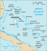
). Its total land area is almost 14000 square kilometres (5,405.4 sq mi), with an estimated population of 330,000. Its capital is Nassau
Nassau, Bahamas
Nassau is the capital, largest city, and commercial centre of the Commonwealth of the Bahamas. The city has a population of 248,948 , 70 percent of the entire population of The Bahamas...
.
Airports
Airport names shown in bold indicate the airport has scheduled service on commercial airlines.| Location served | ICAO ICAO airport code The ICAO airport code or location indicator is a four-character alphanumeric code designating each airport around the world. These codes are defined by the International Civil Aviation Organization, and published in ICAO Document 7910: Location Indicators.The ICAO codes are used by air traffic... |
IATA IATA airport code An IATA airport code, also known an IATA location identifier, IATA station code or simply a location identifier, is a three-letter code designating many airports around the world, defined by the International Air Transport Association... |
Airport name | Runway (ft) |
|---|---|---|---|---|
| ABACO Abaco Islands The Abaco Islands lie in the northern Bahamas and comprise the main islands of Great Abaco and Little Abaco, together with the smaller Wood Cay, Elbow Cay, Lubbers Quarters Cay, Green Turtle Cay, Great Guana Cay, Castaway Cay, Man-o-War Cay, Stranger's Cay, Umbrella Cay, Walker's Cay, Little Grand... |
||||
| Gorda Cay | MYAG | Gorda Cay Airport (private) | by 60 | |
| Marsh Harbour Marsh Harbour Marsh Harbour is a town in Abaco Islands, Bahamas, with a population of 5,314.With more than five thousand residents, Marsh Harbour is the third largest town in The Bahamas, and the main focus of tourism in the Abacos. Marsh Harbour is a shipbuilding center, but tourism accounts for most of its... |
MYAM | MHH | Marsh Harbour Airport Marsh Harbour Airport Marsh Harbour Airport is an airport serving Marsh Harbour, a town in the Abaco Islands in The Bahamas.Marsh Harbour is a major tourist attraction in the Bahamas. The airport serves Nassau and a few Florida cities... |
x 100 |
| Mores Island | MYAO | Mores Island Airport | by 100 | |
| Sandy Point Sandy Point, Bahamas Sandy Point is a town in the Bahamas located in the South Abaco District. It is the last settlement in the southern end of the chain. Sandy Point was named because of the amount of sand on its beaches. It is south of the famous Disney castaway island .... |
MYAS | Sandy Point Airport Sandy Point Airport Sandy Point Airport is an airstrip serving Sandy Point on Abaco Island in The Bahamas.-Facilities:The airport resides at an elevation of above mean sea level. It has one runway designated 10/28 with an asphalt surface measuring .... |
by 80 | |
| Scotland Cay | MYXI | Scotland Cay Airport (private) | x 100 | |
| Spanish Cay | MYAX | Spanish Cay Airport Spanish Cay Airport Spanish Cay Airport is an airstrip serving Spanish Cay, one of the Abaco Islands in The Bahamas.-Facilities:The airport resides at an elevation of above mean sea level. It has one runway designated 14/32 with a asphalt surface measuring .... |
by 80 | |
| Treasure Cay Treasure Cay Treasure Cay, Bahamas is a small coastal community on the east coast of the island of Abaco in the Bahamas. Treasure Cay is approximately 165 miles due east of Fort Lauderdale, Florida, United States.... |
MYAT | TCB | Treasure Cay Airport Treasure Cay Airport Treasure Cay Airport is an airport serving Treasure Cay, in the Abaco Islands in The Bahamas.-Facilities:The airport resides at an elevation of above mean sea level. It has one runway designated 14/32 with an asphalt surface measuring .... |
x 150 |
| Walker Cay | MYAW | WKR | Walker Cay Airport | by 80 |
| ACKLINS Acklins Acklins is an island and district of the Bahamas.It is one of a group of islands arranged along a large, shallow lagoon called the Bight of Acklins, of which the largest are Crooked Island in the north and Acklins in the southeast, and the smaller are Long Cay [ 8sq mi] in the northwest, and... |
||||
| Spring Point | MYAP | AXP | Spring Point Airport Spring Point Airport Spring Point Airport is an airport serving Spring Point on Acklins Island in The Bahamas. Bahamasair flies to Spring Point Airport, and it is the only airline that flies here.-Facilities:The airport resides at an elevation of above mean sea level... |
by 150 |
| ANDROS Andros, Bahamas Andros Island is an archipelago within the archipelago-nation of the Bahamas, the largest of the 26 inhabited Bahamian Islands. Geo-politically considered a single island, Andros has an area greater than all the other 700 Bahamian islands combined... |
||||
| Andros Town Andros Town Andros Town is a town located in North Andros, part of Andros island in The Bahamas. It is the capital of Andros Island.-See also:* List of cities in the Bahamas* Districts of the Bahamas* Islands of the Bahamas... , North Andros North Andros North Andros is one of the 31 Districts of The Bahamas. It is also the largest district in the country. It has some of the largest settlements on Andros Island and many churches as well.- Churches :... |
MYAF | ASD | Andros Town Airport (Fresh Creek Airport) | by 100 |
| Congo Town Congo Town Congo Town is a town located in South Andros, part of Andros Island in the Bahamas.-See also:* List of cities in the Bahamas* Districts of the Bahamas* Islands of the Bahamas... , South Andros South Andros South Andros is a district of the nation of The Bahamas. Geographically, South Andros is the southernmost third of the land mass colloquially called Andros, which includes the districts of North Andros, Central Andros and South Andros... |
MYAK | COX / TZN | Congo Town Airport Congo Town Airport Congo Town Airport is an airport near Congo Town in South Andros, part of Andros Island in The Bahamas. It is also known as South Andros Airport .-Facilities:... (South Andros Airport) |
by 100 |
| Mangrove Cay Mangrove Cay Mangrove Cay is one of the districts of the Bahamas, on Andros Island.... |
MYAB | MAY | Clarence A. Bain Airport Clarence A. Bain Airport Clarence A. Bain Airport is an airport serving Mangrove Cay, part of Andros Island in The Bahamas.-Facilities:The airport resides at an elevation of above mean sea level. It has one runway designated 09/27 with a asphalt surface measuring .... |
by 75 |
| Nicholls Town Nicholls Town Nicholls Town is a town located in North Andros, part of Andros island in the Bahamas.-See also:* Districts of the Bahamas* Islands of the Bahamas* List of cities in the Bahamas... , North Andros North Andros North Andros is one of the 31 Districts of The Bahamas. It is also the largest district in the country. It has some of the largest settlements on Andros Island and many churches as well.- Churches :... |
MYAN | SAQ | San Andros Airport San Andros Airport San Andros Airport is an airport near Nicholls Town on Andros Island in The Bahamas.-Facilities:The airport resides at an elevation of above mean sea level... |
by 75 |
| Andros | Andros Central Airport (closed) | by 150 | ||
| BERRY ISLANDS Berry Islands The Berry Islands are a chain of islands and a district of the Bahamas, covering about thirty square miles of the north western part of the Out Islands... |
||||
| Big Whale Cay | MYBW | Big Whale Cay Airport | by 60 | |
| Chub Cay | MYBC | CCZ | Chub Cay International Airport Chub Cay International Airport Chub Cay Airport is an airport in Chub Cay in the Berry Islands in Bahamas . The airport actually lies in Frazers Hog Cay.-External links:*... |
by 80 |
| Great Harbour Cay | MYBG | GHC | Great Harbour Cay Airport Great Harbour Cay Airport Great Harbour Cay Airport is an airport serving Great Harbour Cay, one of the Berry Islands in The Bahamas.-Facilities:The airport resides at an elevation of above mean sea level. It has one runway designated 13/31 with a asphalt surface measuring .... |
by 80 |
| Lt. Whale Cay | MYBX | Lt. Whale Cay Airport | by 50 | |
| BIMINI Bimini Bimini is the westernmost district of the Bahamas composed of a chain of islands located about 53 miles due east of Miami, Florida. Bimini is the closest point in the Bahamas to the mainland United States and approximately 137 miles west-northwest of Nassau... |
||||
| Cat Cay | MYCC | CXY | Cat Cay Airport | by 50 |
| Ocean Cay | MYBO | Ocean Cay Airport | by 60 | |
| South Bimini | MYBS | BIM | South Bimini Airport South Bimini Airport -External links:*... |
by 100 |
| CAT ISLAND Cat Island (Bahamas) Cat Island is in the central Bahamas, and one of its districts, and has the nation's highest point. Its Mount Alvernia rises to 206 ft and is topped by a monastery called The Hermitage. This assembly of buildings was erected by the Franciscan "Brother Jerome" .The first European settlers were... |
||||
| Arthur's Town Arthur's Town Arthur's Town is a town in the Bahamas and has a population of 400 . It is located on Cat Island.Arthur's Town Airport is located in the town.... |
MYCA | ATC | Arthur's Town Airport Arthur's Town Airport Arthur's Town Airport is an airport in Arthur's Town on Cat Island in the Bahamas.-Charter flights:Aeroshares Charter, LLC services Cat Island from worldwide locations.Charter service is also available from Florida or Nassau.... |
by 150 |
| Cutlass Bay | MYCX | Cutlass Bay Airport | by 60 | |
| Hawks Nest | MYCH | Hawks Nest Airport | by 80 | |
| New Bight | MYCB | CAT | New Bight Airport New Bight Airport New Bight Airport is an airport in New Bight on Cat Island in The Bahamas.-Facilities:The airport resides at an elevation of above mean sea level. It has one runway designated 09/27 with an asphalt surface measuring .-Airlines and destinations:... |
by 75 |
| CAY SAL | ||||
| Cay Sal | MYCS | Cay Sal Airport (private) | by 100 | |
| CROOKED ISLAND Acklins and Crooked Islands Acklins and Crooked Islands was a district of the Bahamas until 1996, and as Acklins, Crooked Island and Long Cay until 1999.... |
||||
| Colonel Hill Colonel Hill Colonel Hill is a town in the Bahamas, located on Crooked Island.... |
MYCI | CRI | Colonel Hill Airport (Crooked Island Airport) | by 60 |
| Pitts Town | MYCP | PWN | Pitts Town Airport | by 60 |
| ELEUTHERA Eleuthera Eleuthera is an island in The Bahamas, lying 50 miles east of Nassau. It is very long and thin—110 miles long and in places little more than a mile wide. According to the 2000 Census, the population of Eleuthera is approximately 8,000... |
||||
| Cape Eleuthera | MYEC | CEL | Cape Eleuthera Airport (closed) | by 150 |
| Governor's Harbour Governor's Harbour Governor's Harbour is a former district of the Bahamas. It corresponds roughly to the current district of Central Eleuthera.... |
MYEM | GHB | Governor's Harbour Airport | by 150 |
| North Eleuthera North Eleuthera North Eleuthera is one of the districts of the Bahamas, on the island of Eleuthera.Sweetings Pond in North Central Eleuthera is recognized as a site of special ecological value, containing, it is estimated, a concentration of Ophiothrix oerstedi brittlestars at up to 434 individuals per square... |
MYEH | ELH | North Eleuthera Airport | by 100 |
| Rock Sound Rock Sound, Bahamas Rock Sound is a former district of the Bahamas. It corresponds roughly to the current district of South Eleuthera.... |
MYER | RSD | Rock Sound International Airport Rock Sound International Airport Rock Sound International Airport is an airport at Rock Sound on Eleuthera in the Bahamas.... |
by 150 |
| EXUMA Exuma Exuma is a district of the Bahamas, consisting of over 360 islands . The largest of the cays is Great Exuma, which is 37 mi in length and joined to another island, Little Exuma by a small bridge. The capital and largest city in the district is George Town , founded 1793 and located on Great... |
||||
| Black Point | MYEB | Black Point Airport | by 80 | |
| Darby Island | Darby Island Airport (private) | by 100 | ||
| Farmers Cay | Farmers Cay Airport | by 50 | ||
| Great Exuma Island Exuma Exuma is a district of the Bahamas, consisting of over 360 islands . The largest of the cays is Great Exuma, which is 37 mi in length and joined to another island, Little Exuma by a small bridge. The capital and largest city in the district is George Town , founded 1793 and located on Great... (George Town) |
MYEG | George Town Airport George Town Airport George Town Airport is an airport located near George Town on the island of Great Exuma in The Bahamas.-Facilities:The airport resides at an elevation of above mean sea level... |
by 90 | |
| Great Exuma Island Exuma Exuma is a district of the Bahamas, consisting of over 360 islands . The largest of the cays is Great Exuma, which is 37 mi in length and joined to another island, Little Exuma by a small bridge. The capital and largest city in the district is George Town , founded 1793 and located on Great... (Moss Town) |
MYEF | GGT | Exuma International Airport Exuma International Airport Exuma International Airport is a public airport serving the island of Great Exuma in the Bahamas. It is located near Moss Town, northwest of George Town. The airport services mainly light aircraft and regional jets from the United States and The Bahamas.... |
by 100 |
| Hog Cay | MYEY | Hog Cay Airport | by 60 | |
| Lee Stocking | MYXE | Lee Stocking Airport | by 75 | |
| Little Darby Island | MYXF | Little Darby Island Airport (private) | by 75 | |
| Norman's Cay Norman's Cay Norman's Cay is a small Bahamian island in the Exumas, a chain of islands south and east of Nassau, that served as the headquarters for Carlos Lehder's drug-smuggling operation from 1978 to around 1982.-Drug smuggling history:... |
MYEN | NMC | Norman's Cay Airport Norman's Cay Airport Norman's Cay Airport is an airport serving Norman's Cay, one of the Exuma Islands in The Bahamas.-Facilities:The airport resides at an elevation of above mean sea level. It has one runway designated 03/21 with an asphalt surface measuring .... |
by 70 |
| Rudder Cut Cay | Rudder Cut Cay Airport | by 60 | ||
| Sampson Cay | MYXH | Sampson Cay Airport (private) | by 30 | |
| Staniel Cay | MYES | TYM | Staniel Cay Airport Staniel Cay Airport Staniel Cay Airport is an airport serving Staniel Cay, one of the Exuma Islands in The Bahamas.-Facilities:The airport resides at an elevation of above mean sea level. It has one runway designated 17/35 with a asphalt surface measuring .... |
by 75 |
| GRAND BAHAMA Grand Bahama Grand Bahama is one of the northernmost of the islands of the Bahamas, and the closest major island to the United States, lying off the state of Florida. Grand Bahama is the fifth largest island in the Bahamas island chain of approximately 700 islands and 2,400 cays... |
||||
| Freeport Freeport, Bahamas Freeport is a city, district and free trade zone located on the island of Grand Bahama of the North-west Bahamas. In 1955, Wallace Groves, a Virginian financier with lumber interests in Grand Bahama, was granted 50,000 acres Freeport is a city, district and free trade zone located on the island of... |
MYGF | FPO | Grand Bahama International Airport Grand Bahama International Airport Grand Bahama International Airport is a privately owned international airport in Freeport, Bahamas. The airport is a joint venture between Hutchison Port Holdings and The Port Group... (Freeport Int'l) |
by 150 |
| Grand Bahama Grand Bahama Grand Bahama is one of the northernmost of the islands of the Bahamas, and the closest major island to the United States, lying off the state of Florida. Grand Bahama is the fifth largest island in the Bahamas island chain of approximately 700 islands and 2,400 cays... |
MYGW | WTD | West End Airport West End Airport West End Airport is an airport that serves Grand Bahama. While smaller than the other airport on the island located in Freeport, this airport has two runways each in length. This airport was recently re-opened and serves mostly cargo aircraft. The main runway is runway 10 and is the westernmost... (reopened) |
by 150 |
| INAGUA Inagua Inagua is the southernmost district of the Bahamas comprising the islands of Great Inagua and Little Inagua.Great Inagua is the third largest island in The Bahamas at 596 sq mi and lies about 55 miles from the eastern tip of Cuba. The island is about 55 x 19 miles in extent, the highest point... |
||||
| Matthew Town Matthew Town Matthew Town is the chief and only settlement on Great Inagua Island of the Bahamas. It is located on the southwest corner of the island. It was named after Bahamian Governor George Matthew and first settled during his tenure in office... |
MYIG | IGA | Inagua Airport (Matthew Town Airport) | by 100 |
| LONG ISLAND | ||||
| Cape Santa Maria | MYLM | Cape Santa Maria Airport | by 60 | |
| Deadman's Cay | MYLD | LGI | Deadman's Cay Airport Deadman's Cay Airport Deadman's Cay Airport is an airport located near Deadman's Cay on Long Island in The Bahamas.-Facilities:The airport resides at an elevation of above mean sea level. It has one runway designated 09/27 with an asphalt surface measuring .... |
by 80 |
| Long Island | MYLR | Hard Bargain Airport | by 60 | |
| Long Island | MYLS | SML | Stella Maris Airport Stella Maris Airport Stella Maris Airport is an airport located near Stella Maris, on Long Island in The Bahamas.-Facilities:The airport resides at an elevation of above mean sea level... |
by 90 |
| MAYAGUANA Mayaguana Mayaguana is the most easterly island and district of the Bahamas. It is one of only a few Bahamian islands which retain their Lucayan names. The population of Mayaguana in the 2000 census was 259, amounting to an estimate 312 in 2010... |
||||
| Mayaguana Mayaguana Mayaguana is the most easterly island and district of the Bahamas. It is one of only a few Bahamian islands which retain their Lucayan names. The population of Mayaguana in the 2000 census was 259, amounting to an estimate 312 in 2010... |
MYMM | MYG | Mayaguana Airport | by 150 |
| NEW PROVIDENCE New Providence New Providence is the most populous island in the Bahamas, containing more than 70% of the total population. It also houses the national capital city, Nassau.The island was originally under Spanish control following Christopher Columbus' discovery of the New World, but the Spanish government showed... |
||||
| Nassau Nassau, Bahamas Nassau is the capital, largest city, and commercial centre of the Commonwealth of the Bahamas. The city has a population of 248,948 , 70 percent of the entire population of The Bahamas... |
MYNN | NAS | Lynden Pindling International Airport Lynden Pindling International Airport - Trivia :During World War II,it was known as Windsor Field used by the Royal Air Force Transferring Fighter and Bomber aircraft such as the B-17, B-24, and the P-40 from New Providence to Italian, North African and European Theatres of War and as a station for Consolidated Liberator I and North... |
by 150 |
| Paradise Island Paradise Island Paradise Island is an island in the Bahamas formerly known as Hog Island. The island is located just off the shore of the city of Nassau, which is itself located on the northern edge of the island of New Providence. It is best known for the sprawling 'Vegas-by-the-sea resort' Atlantis.Paradise... |
MYPI | PID | New Providence Airport | |
| RAGGED ISLAND Ragged Island Ragged Island is a small island and district in the southern Bahamas.Until recently it had an active salt industry, the salt ponds having been developed in the 19th Century by a Mr... |
||||
| Duncan Town | MYRD | DCT | Duncan Town Airport Duncan Town Airport Duncan Town Airport is an airport located near Duncan Town, on Ragged Island in The Bahamas.-Facilities:The airport resides at an elevation of above mean sea level. It has one runway designated 13/31 with an asphalt surface measuring .... |
by 75 |
| RUM CAY Rum Cay Rum Cay is an island and district of the Bahamas. Lat.: N23 42' 30" - Long.: W 74 50' 00" - Size: 30 Sq. mlsRum Cay is 20 miles southwest of San Salvador Island, has many rolling hills that rises to about 120 feet . Christopher Columbus called it Santa Maria de la Concepción. The island is... |
||||
| Port Nelson | MYRP | RCY | Port Nelson Airport Port Nelson Airport Port Nelson Airport or New Port Nelson Airport is an airport located near Port Nelson, on Rum Cay in The Bahamas.-Facilities:The airport resides at an elevation of above mean sea level. It has one runway designated 09/27 with an asphalt surface measuring .... |
by 80 |
| SAN SALVADOR San Salvador Island San Salvador Island, also known as Watlings Island, is an island and district of the Bahamas. Until 1986, when the National Geographic Society suggested Samana Cay, it was widely believed that during his first expedition to the New World, San Salvador Island was the first land sighted and visited... |
||||
| Cockburn Town | MYSM | ZSA | San Salvador Airport San Salvador Airport San Salvador Airport , also known as Cockburn Town Airport, is an airport in San Salvador, Bahamas.San Salvador International Airport is one of the few airports in the Bahamas that has Instrument rating landing for airplanes, and as a result aircraft can now land at ZSA after official sunset... (Cockburn Town Airport) |
by 180 |
See also
- List of airports by ICAO code: M#MY - Bahamas
- List of islands of the Bahamas
- List of islands of the Bahamas by total area
- Districts of the BahamasDistricts of the BahamasLocal government in the Bahamas exists in two forms, namely second-schedule and third-schedule district councils. There are a total of 32 local government districts: 13 second-schedule districts, which are further sub-divided into town areas, and 19 third-schedule districts, which are all unitary...
- Transport in the BahamasTransport in the Bahamas-Highways:Approximately of road in the Bahamas is classified as highway. Of these, approximately are paved. As a former British colony, drivers drive on the left.-Ports and harbours:...
- Wikipedia: WikiProject Aviation/Airline destination lists: North America#Bahamas