

List of Ultras in Oceania
Encyclopedia
This is a list of all the Ultra prominent peak
s (with topographic prominence
greater than 1,500 metres) in Oceania
, along with the Indian Ocean islands.
Australia
New Zealand
Papua New Guinea
Indonesia
See also: List of Ultras in Indonesia for other ultra prominent peaks elsewhere in the Indonesian archipelago.
Pacific Islands
Hawaii
Indian Ocean
Ultra prominent peak
An ultra prominent peak, or Ultra for short, is a mountain with a topographic prominence of or more. There are a total of roughly 1,524 such peaks in the world. Some are famous even to non-climbers, such as Mount Everest, Aconcagua, and Mount McKinley , while others are much more obscure...
s (with topographic prominence
Topographic prominence
In topography, prominence, also known as autonomous height, relative height, shoulder drop , or prime factor , categorizes the height of the mountain's or hill's summit by the elevation between it and the lowest contour line encircling it and no higher summit...
greater than 1,500 metres) in Oceania
Oceania
Oceania is a region centered on the islands of the tropical Pacific Ocean. Conceptions of what constitutes Oceania range from the coral atolls and volcanic islands of the South Pacific to the entire insular region between Asia and the Americas, including Australasia and the Malay Archipelago...
, along with the Indian Ocean islands.
AustraliaAustraliaAustralia , officially the Commonwealth of Australia, is a country in the Southern Hemisphere comprising the mainland of the Australian continent, the island of Tasmania, and numerous smaller islands in the Indian and Pacific Oceans. It is the world's sixth-largest country by total area...
| No | Peak | Country | Elevation (m) | Prominence (m) | Col (m) |
|---|---|---|---|---|---|
| 1 | Mount Kosciuszko Mount Kosciuszko Mount Kosciuszko is a mountain located in the Snowy Mountains in Kosciuszko National Park. With a height of 2,228 metres above sea level, it is the highest mountain in Australia... |
2,228 | 2,228 | 0 | |
| 2 | Mount Ossa | (Tasmania Tasmania Tasmania is an Australian island and state. It is south of the continent, separated by Bass Strait. The state includes the island of Tasmania—the 26th largest island in the world—and the surrounding islands. The state has a population of 507,626 , of whom almost half reside in the greater Hobart... ) |
1,617 | 1,617 | 0 |
New ZealandNew ZealandNew Zealand is an island country in the south-western Pacific Ocean comprising two main landmasses and numerous smaller islands. The country is situated some east of Australia across the Tasman Sea, and roughly south of the Pacific island nations of New Caledonia, Fiji, and Tonga...
| No | Peak | Country | Elevation (m) | Prominence (m) | Col (m) |
|---|---|---|---|---|---|
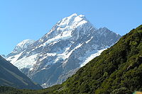
| 1 | Aoraki/Mount Cook Aoraki/Mount Cook Aoraki / Mount Cook is the highest mountain in New Zealand, reaching .It lies in the Southern Alps, the mountain range which runs the length of the South Island. A popular tourist destination, it is also a favourite challenge for mountain climbers... |
(South Island South Island The South Island is the larger of the two major islands of New Zealand, the other being the more populous North Island. It is bordered to the north by Cook Strait, to the west by the Tasman Sea, to the south and east by the Pacific Ocean... ) |
3,755 | 3,755 | 0 |
| 2 | Mount Ruapehu Mount Ruapehu Mount Ruapehu, or just Ruapehu, is an active stratovolcano at the southern end of the Taupo Volcanic Zone in New Zealand. It is 23 kilometres northeast of Ohakune and 40 kilometres southwest of the southern shore of Lake Taupo, within Tongariro National Park... |
(North Island North Island The North Island is one of the two main islands of New Zealand, separated from the much less populous South Island by Cook Strait. The island is in area, making it the world's 14th-largest island... ) |
2,797 | 2,797 | 0 |
| 3 | Mount Aspiring/Tititea | (South Island South Island The South Island is the larger of the two major islands of New Zealand, the other being the more populous North Island. It is bordered to the north by Cook Strait, to the west by the Tasman Sea, to the south and east by the Pacific Ocean... ) |
3,033 | 2,471 | 562 |
| 4 | Mount Taranaki/Egmont | (North Island North Island The North Island is one of the two main islands of New Zealand, separated from the much less populous South Island by Cook Strait. The island is in area, making it the world's 14th-largest island... ) |
2,518 | 2,308 | 210 |
| 5 | Mount Tutoko Mount Tutoko Mount Tutoko is the highest peak in Fiordland National Park, in southwest New Zealand. It lies between the Hollyford Valley and Milford Sound, 15 kilometres due north of the Homer Tunnel, and rises to a height of 2756 m... |
(South Island South Island The South Island is the larger of the two major islands of New Zealand, the other being the more populous North Island. It is bordered to the north by Cook Strait, to the west by the Tasman Sea, to the south and east by the Pacific Ocean... ) |
2,723 | 2,191 | 532 |
| 6 | Mount Tapuaenuku Mount Tapuaenuku Tapuae-o-Uenuku, formerly Mount Tapuaenuku, is the highest peak in the northeast of New Zealand's South Island. The name translates from Māori as "footprint of the rainbow", though is usually regarded as being named after Chief Tapuaenuku.... |
(South Island South Island The South Island is the larger of the two major islands of New Zealand, the other being the more populous North Island. It is bordered to the north by Cook Strait, to the west by the Tasman Sea, to the south and east by the Pacific Ocean... ) |
2,884 | 2,021 | 863 |
| 7 | The Remarkables | (South Island South Island The South Island is the larger of the two major islands of New Zealand, the other being the more populous North Island. It is bordered to the north by Cook Strait, to the west by the Tasman Sea, to the south and east by the Pacific Ocean... ) |
2,319 | 1,969 | 350 |
| 8 | Manakau Manakau (mountain) Manakau is a mountain peak in the Marlborough region of New Zealand's South Island. At 2608 metres, it is the highest peak of the Seaward Kaikoura Range-References:* New Zealand Topographic Map 1:50000 series sheet BT27 - Kaikoura... |
(South Island South Island The South Island is the larger of the two major islands of New Zealand, the other being the more populous North Island. It is bordered to the north by Cook Strait, to the west by the Tasman Sea, to the south and east by the Pacific Ocean... ) |
2,608 | 1,798 | 810 |
| 9 | Mount Taylor | (South Island South Island The South Island is the larger of the two major islands of New Zealand, the other being the more populous North Island. It is bordered to the north by Cook Strait, to the west by the Tasman Sea, to the south and east by the Pacific Ocean... ) |
2,333 | 1,636 | 698 |
| 10 | HP Skippers Range | (South Island South Island The South Island is the larger of the two major islands of New Zealand, the other being the more populous North Island. It is bordered to the north by Cook Strait, to the west by the Tasman Sea, to the south and east by the Pacific Ocean... ) |
1,648 | 1,598 | 50 |
Papua New GuineaPapua New GuineaPapua New Guinea , officially the Independent State of Papua New Guinea, is a country in Oceania, occupying the eastern half of the island of New Guinea and numerous offshore islands...
| No | Peak | Country | Elevation (m) | Prominence (m) | Col (m) |
|---|---|---|---|---|---|
| 1 | Finisterre Range Finisterre Range Finisterre Range is a mountain range in north-eastern Papua New Guinea, at . The unnamed highest point of the range , which is ranked 45th in the world by prominence, is usually quoted at 4,175 m, but SRTM data suggests that it is nearer to 4,120 m... HP |
4,175 | 3,734 | 441 | |
| 2 | Mount Suckling Mount Suckling Mount Suckling or Goropi, is the highest peak of the Goropu Mountains, part of the Owen Stanley Range in southeastern Papua New Guinea. It lies about east of Port Moresby. Situated on a relatively narrow peninsula, it lies only about from the sea to both the northeast and the south... |
3,676 | 2,976 | 700 | |
| 3 | Mount Wilhelm Mount Wilhelm Mount Wilhelm is the highest mountain in Papua New Guinea at . It is part of the Bismarck Range and the peak is the point where three provinces intersect, Simbu, Western Highlands and Madang... |
4,509 | 2,969 | 1540 | |
| 4 | Mount Victoria Mount Victoria, Papua New Guinea Mount Victoria is the highest point in the Owen Stanley Ranges in Central Province, Papua New Guinea at 4,072 metres. It lies approximately 75 km north-north-west of Port Moresby and can be seen on a clear day from the city.-History:... |
4,038 | 2,738 | 1300 | |
| 5 | Mount Balbi Mount Balbi Mount Balbi is a Holocene stratovolcano located in the northern portion of the island of Bougainville, Papua New Guinea. It is the highest point of the island. There are five volcanic craters along a ridge north of the summit, one of which contains a crater lake. There are numerous fumaroles near... |
(Bougainville Island Bougainville Island Bougainville Island is the main island of the Autonomous Region of Bougainville of Papua New Guinea. This region is also known as Bougainville Province or the North Solomons. The population of the province is 175,160 , which includes the adjacent island of Buka and assorted outlying islands... ) |
2,715 | 2,715 | 0 |
| 6 | Mount Oiautukekea | (Goodenough Island Goodenough Island Goodenough Island in the Solomon Sea is the westernmost of the three large islands of the D'Entrecasteaux Islands in Milne Bay Province of Papua New Guinea. It lies to the east of mainland New Guinea and south west of the Trobriand Islands.It should not be confused with Goodenough's Island... ) |
2,536 | 2,536 | 0 |
| 7 | Mount Giluwe Mount Giluwe Mount Giluwe is the second highest mountain in Papua New Guinea at . It is located in the Southern Highlands province and is an old shield volcano with vast alpine grasslands. Ancient volcanic plugs form its two summits, with the central peak the highest and an east peak about away at... |
4,367 | 2,507 | 1860 | |
| 8 | New Ireland New Ireland (island) New Ireland is a large island in Papua New Guinea, approximately 7,404 km² in area. It is the largest island of the New Ireland Province, lying northeast of the island of New Britain. Both islands are part of the Bismarck Archipelago, named after Otto von Bismarck, and they are separated by... HP |
(New Ireland New Ireland (island) New Ireland is a large island in Papua New Guinea, approximately 7,404 km² in area. It is the largest island of the New Ireland Province, lying northeast of the island of New Britain. Both islands are part of the Bismarck Archipelago, named after Otto von Bismarck, and they are separated by... ) |
2,340 | 2,340 | 0 |
| 9 | Mount Ulawun | (New Britain New Britain New Britain, or Niu Briten, is the largest island in the Bismarck Archipelago of Papua New Guinea. It is separated from the island of New Guinea by the Dampier and Vitiaz Straits and from New Ireland by St. George's Channel... ) |
2,334 | 2,334 | 0 |
| 10 | Mount Kabangama | 4,104 | 2,284 | 1820 | |
| 11 | Nakanai Mountains HP | (New Britain New Britain New Britain, or Niu Briten, is the largest island in the Bismarck Archipelago of Papua New Guinea. It is separated from the island of New Guinea by the Dampier and Vitiaz Straits and from New Ireland by St. George's Channel... ) |
2,316 | 2,056 | 260 |
| 12 | Mount Kilkerran | (Fergusson Island Fergusson Island Fergusson Island is the largest island of the D'Entrecasteaux Islands, in Papua New Guinea. It has an area of just over 500 square miles , and mostly consists of mountainous regions, covered by rain forests... ) |
1,947 | 1,947 | 0 |
| 13 | Mount Piora | 3,557 | 1,897 | 1660 | |
| 14 | Mount Bosavi Mount Bosavi Mount Bosavi is a mountain in the Southern Highlands province, Papua New Guinea. It is the collapsed cone of an extinct volcano on the Great Papuan Plateau, part of the Kikori River basin. The crater is approximately 4 km wide and 1 km deep; it is home to a number of unique species.Part... |
2,507 | 1,887 | 620 | |
| 15 | Mount Karoma | 3,623 | 1,883 | 1740 | |
| 16 | Mount Simpson | 2,883 | 1,863 | 1020 | |
| 17 | Mount Kunugui | (Karkar Island Karkar Island Karkar Island is an oval-shaped volcanic island located in the Bismarck Sea, about 30 kilometres off the north coast of mainland Papua New Guinea in Madang Province. The island is about 25 km in length and 19 km in width. In the centre is an active volcano with two nested calderas... ) |
1,833 | 1,833 | 0 |
| 18 | Mount Victory | 1,891 | 1,831 | 60 | |
| 19 | Manam Manam Manam, known locally as Manam Motu, is an island located in the Bismarck Sea across the Stephan Strait from the northeast coast of mainland Papua New Guinea. The island is 10 kilometers wide, and was created by the activity of the Manam Volcano, one of the country’s most active... HP |
(Manam Manam Manam, known locally as Manam Motu, is an island located in the Bismarck Sea across the Stephan Strait from the northeast coast of mainland Papua New Guinea. The island is 10 kilometers wide, and was created by the activity of the Manam Volcano, one of the country’s most active... ) |
1,807 | 1,807 | 0 |
| 20 | Mount Michael Mount Michael Mount Michael is an active volcanic mountain, 805 m, surmounting Saunders Island in the South Sandwich Islands. It is a part of the British Overseas Territory, the South Georgia and the South Sandwich Islands and is one of the few volcanos in the United Kingdom... |
3,647 | 1,787 | 1860 | |
| 21 | Mount Talawe | (New Britain New Britain New Britain, or Niu Briten, is the largest island in the Bismarck Archipelago of Papua New Guinea. It is separated from the island of New Guinea by the Dampier and Vitiaz Straits and from New Ireland by St. George's Channel... ) |
1,824 | 1,773 | 51 |
| 22 | Barurumea Ridge | (New Britain New Britain New Britain, or Niu Briten, is the largest island in the Bismarck Archipelago of Papua New Guinea. It is separated from the island of New Guinea by the Dampier and Vitiaz Straits and from New Ireland by St. George's Channel... ) |
2,063 | 1,723 | 340 |
| 23 | Mount Sarawaget Mount Bangeta Mount Bangeta, also known as Mount Sarawaget, is the highest mountain in Morobe Province, Papua New Guinea. It lies in the Saruwaged Range and at it is one of the highest mountains in the country.... |
4,121 | 1,701 | 2420 | |
| 24 | Bewani Mountains Bewani Mountains Bewani Mountains is a mountain range in northwestern Papua New Guinea. Together with the Torricelli Mountains and Prince Alexander Mountains it forms the North Coastal Range of Papua New Guinea... HP |
1,980 | 1,664 | 316 | |
| 25 | Mount Bel | (Umboi Island Umboi Island Umboi is a volcanic island between the mainland of Papua New Guinea and the island of New Britain. It is separated from New Britain by Dampier Strait and has an elevation of 1,548 m. Umboi is a Holocene complex volcano with no historic eruptions... ) |
1,658 | 1,658 | 0 |
| 26 | unnamed | (New Britain New Britain New Britain, or Niu Briten, is the largest island in the Bismarck Archipelago of Papua New Guinea. It is separated from the island of New Guinea by the Dampier and Vitiaz Straits and from New Ireland by St. George's Channel... ) |
1,951 | 1,651 | 300 |
| 27 | Mount Maybole | (Fergusson Island Fergusson Island Fergusson Island is the largest island of the D'Entrecasteaux Islands, in Papua New Guinea. It has an area of just over 500 square miles , and mostly consists of mountainous regions, covered by rain forests... ) |
1,665 | 1,597 | 68 |
| 28 | Adelbert Range Adelbert Range Adelbert Range is a mountain range in Madang Province, north-central Papua New Guinea, at . Highest point of the mountains is at 1716 m. As other mountain ranges in Papua New Guinea it is cloaked in rainforest and is home to many rare species of fauna and flora and is highly biodiverse. Adelbert... HP |
1,716 | 1,576 | 140 | |
| 29 | Sibium Mountains HP | 2,295 | 1,555 | 740 | |
| 30 | Mount Shungol | 2,752 | 1,518 | 1234 | |
| 31 | Mount Taraka | (Bougainville Island Bougainville Island Bougainville Island is the main island of the Autonomous Region of Bougainville of Papua New Guinea. This region is also known as Bougainville Province or the North Solomons. The population of the province is 175,160 , which includes the adjacent island of Buka and assorted outlying islands... ) |
2,251 | 1,511 | 740 |
IndonesiaPapua (Indonesian province)Papua comprises most of the western half of the island of New Guinea and nearby islands. Its capital is Jayapura. It's the largest and easternmost province of Indonesia. The province originally covered the entire western half of New Guinea...
| No | Peak | Country | Elevation (m) | Prominence (m) | Col (m) |
|---|---|---|---|---|---|
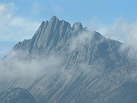
| 1 | Puncak Jaya (Carstensz Pyramid) Puncak Jaya Puncak Jaya or Carstensz Pyramid is the highest summit of Mount Carstensz in the Sudirman Range of the western central highlands of Papua province, Indonesia . Other summits are East Carstensz Peak and Ngga Pulu... |
(New Guinea New Guinea New Guinea is the world's second largest island, after Greenland, covering a land area of 786,000 km2. Located in the southwest Pacific Ocean, it lies geographically to the east of the Malay Archipelago, with which it is sometimes included as part of a greater Indo-Australian Archipelago... ) |
4,884 | 4,884 | 0 |
| 2 | Mount Arfak | (New Guinea New Guinea New Guinea is the world's second largest island, after Greenland, covering a land area of 786,000 km2. Located in the southwest Pacific Ocean, it lies geographically to the east of the Malay Archipelago, with which it is sometimes included as part of a greater Indo-Australian Archipelago... ) |
2,940 | 2,761 | 179 |
| 3 | Puncak Mandala Puncak Mandala Puncak Mandala , is a mountain located in Papua, Indonesia. Following Mount Carstensz 350 km to the east, Mandala is the second highest freestanding mountain of Oceania, Australasia, New Guinea and Indonesia.-Further reading:* at GunungBagging.com... |
(New Guinea New Guinea New Guinea is the world's second largest island, after Greenland, covering a land area of 786,000 km2. Located in the southwest Pacific Ocean, it lies geographically to the east of the Malay Archipelago, with which it is sometimes included as part of a greater Indo-Australian Archipelago... ) |
4,760 | 2,760 | 2000 |
| 4 | Mount Kobowre | (New Guinea New Guinea New Guinea is the world's second largest island, after Greenland, covering a land area of 786,000 km2. Located in the southwest Pacific Ocean, it lies geographically to the east of the Malay Archipelago, with which it is sometimes included as part of a greater Indo-Australian Archipelago... ) |
3,750 | 2,217 | 1533 |
| 5 | Mount Gauttier | (New Guinea New Guinea New Guinea is the world's second largest island, after Greenland, covering a land area of 786,000 km2. Located in the southwest Pacific Ocean, it lies geographically to the east of the Malay Archipelago, with which it is sometimes included as part of a greater Indo-Australian Archipelago... ) |
2,230 | 2,007 | 223 |
| 6 | Mount Wondiwoi | (New Guinea New Guinea New Guinea is the world's second largest island, after Greenland, covering a land area of 786,000 km2. Located in the southwest Pacific Ocean, it lies geographically to the east of the Malay Archipelago, with which it is sometimes included as part of a greater Indo-Australian Archipelago... ) |
2,180 | 1,985 | 195 |
| 7 | Bon Irau | (New Guinea New Guinea New Guinea is the world's second largest island, after Greenland, covering a land area of 786,000 km2. Located in the southwest Pacific Ocean, it lies geographically to the east of the Malay Archipelago, with which it is sometimes included as part of a greater Indo-Australian Archipelago... ) |
2,500 | 1,900 | 600 |
| 8 | Mount Cycloop | (New Guinea New Guinea New Guinea is the world's second largest island, after Greenland, covering a land area of 786,000 km2. Located in the southwest Pacific Ocean, it lies geographically to the east of the Malay Archipelago, with which it is sometimes included as part of a greater Indo-Australian Archipelago... ) |
2,000 | 1,876 | 124 |
| 9 | Undundi-Wandandi | (New Guinea New Guinea New Guinea is the world's second largest island, after Greenland, covering a land area of 786,000 km2. Located in the southwest Pacific Ocean, it lies geographically to the east of the Malay Archipelago, with which it is sometimes included as part of a greater Indo-Australian Archipelago... ) |
3,640 | 1,740 | 1900 |
| 10 | Mount Kumawa | (New Guinea New Guinea New Guinea is the world's second largest island, after Greenland, covering a land area of 786,000 km2. Located in the southwest Pacific Ocean, it lies geographically to the east of the Malay Archipelago, with which it is sometimes included as part of a greater Indo-Australian Archipelago... ) |
1,680 | 1,636 | 44 |
| 11 | Angemuk | (New Guinea New Guinea New Guinea is the world's second largest island, after Greenland, covering a land area of 786,000 km2. Located in the southwest Pacific Ocean, it lies geographically to the east of the Malay Archipelago, with which it is sometimes included as part of a greater Indo-Australian Archipelago... ) |
3,949 | 1,565 | 2384 |
| 12 | Deyjay | (New Guinea New Guinea New Guinea is the world's second largest island, after Greenland, covering a land area of 786,000 km2. Located in the southwest Pacific Ocean, it lies geographically to the east of the Malay Archipelago, with which it is sometimes included as part of a greater Indo-Australian Archipelago... ) |
3,340 | 1,555 | 1785 |
See also: List of Ultras in Indonesia for other ultra prominent peaks elsewhere in the Indonesian archipelago.
Pacific IslandsPacific IslandsThe Pacific Islands comprise 20,000 to 30,000 islands in the Pacific Ocean. The islands are also sometimes collectively called Oceania, although Oceania is sometimes defined as also including Australasia and the Malay Archipelago....
| No | Peak | Country | Elevation (m) | Prominence (m) | Col (m) |
|---|---|---|---|---|---|
| 1 | Mount Popomanaseu Mount Popomanaseu Mount Popomanaseu is the highest mountain in the Solomon Islands. It is located on Guadalcanal east of Mount Makarakomburu. At , it is the highest peak in the insular South Pacific, excluding New Guinea and it's satellite islands. Panning east across the South Pacific, there is no higher mountain... |
(Guadalcanal Guadalcanal Guadalcanal is a tropical island in the South-Western Pacific. The largest island in the Solomons, it was discovered by the Spanish expedition of Alvaro de Mendaña in 1568... ) |
2,335 | 2,335 | 0 |
| 2 | Mont Orohena Mont Orohena Mont Orohena is a mountain of 2,241 m in central Tahiti in French Polynesia in the south Pacific. It is the highest point of French Polynesia. Mont Orohena is an extinct volcano.-References:... |
(Tahiti Tahiti Tahiti is the largest island in the Windward group of French Polynesia, located in the archipelago of the Society Islands in the southern Pacific Ocean. It is the economic, cultural and political centre of French Polynesia. The island was formed from volcanic activity and is high and mountainous... ) |
2,241 | 2,241 | 0 |
| 3 | Mount Tabwemasana Mount Tabwemasana Located on the isolated west coast of Espiritu Santo, Mount Tabwemasana is not only the highest peak in Vanuatu, but also one of the highest mountains in the Pacific. At , Tabwemasana towers above the surrounding mountains and provides fantastic views toward the Coral Sea in East... |
(Espiritu Santo Espiritu Santo Espiritu Santo is the largest island in the nation of Vanuatu, with an area of . It belongs to the archipelago of the New Hebrides in the Pacific region of Melanesia. It is in the Sanma Province of Vanuatu.... ) |
1,879 | 1,879 | 0 |
| 4 | Silisili Silisili Mount Silisili is the highest peak in Samoa and the Samoa Islands chain. It is located in the centre of a mountain chain running the length of Savai'i island.Mount Silisili rises to a height of 1,858 m... |
(Savai'i Savai'i Savaii is the largest and highest island in Samoa and the Samoa Islands chain. It is also the biggest landmass in Polynesia outside Hawaii and New Zealand. The island of Savai'i is also referred to by Samoans as Salafai, a classical Samoan term used in oratory and prose... ) |
1,858 | 1,858 | 0 |
| 5 | Mount Veve Mount Veve Mount Veve is an extinct volcano on Kolombangara, in the Solomon Islands, at . It is 1768 m tall and is the highest point of the island.- External links :*... |
(Kolombangara Kolombangara Kolombangara is an island in the New Georgia Islands group of the Solomon Islands in the southwestern Pacific Ocean... ) |
1,768 | 1,768 | 0 |
| 6 | Mont Panié Mont Panié Mont Panié is the highest peak of New Caledonia with 1,628 meters. It is situated in the range Chaîne Centrale.... |
1,628 | 1,628 | 0 | |
HawaiiHawaiiHawaii is the newest of the 50 U.S. states , and is the only U.S. state made up entirely of islands. It is the northernmost island group in Polynesia, occupying most of an archipelago in the central Pacific Ocean, southwest of the continental United States, southeast of Japan, and northeast of...
| Rank Ranking A ranking is a relationship between a set of items such that, for any two items, the first is either 'ranked higher than', 'ranked lower than' or 'ranked equal to' the second.... |
Peak Summit (topography) In topography, a summit is a point on a surface that is higher in elevation than all points immediately adjacent to it. Mathematically, a summit is a local maximum in elevation... |
State U.S. state A U.S. state is any one of the 50 federated states of the United States of America that share sovereignty with the federal government. Because of this shared sovereignty, an American is a citizen both of the federal entity and of his or her state of domicile. Four states use the official title of... |
Island Island An island or isle is any piece of sub-continental land that is surrounded by water. Very small islands such as emergent land features on atolls can be called islets, cays or keys. An island in a river or lake may be called an eyot , or holm... |
Elevation | Prominence Topographic prominence In topography, prominence, also known as autonomous height, relative height, shoulder drop , or prime factor , categorizes the height of the mountain's or hill's summit by the elevation between it and the lowest contour line encircling it and no higher summit... |
Isolation Topographic isolation The topographic isolation of a summit is the minimum horizontal distance to the nearest point of higher elevation. Topographic isolation represents a radius of dominance in which the summit is the highest point. Topographic isolation can be calculated for small hills and islands as well as for... |
Location Geographic coordinate system A geographic coordinate system is a coordinate system that enables every location on the Earth to be specified by a set of numbers. The coordinates are often chosen such that one of the numbers represent vertical position, and two or three of the numbers represent horizontal position... |
|---|---|---|---|
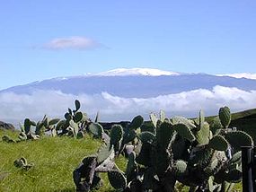
| 1 |
 Hawaii Hawaii |
Island of Hawaiʻi |
19.8207°N 155.4680°W |
| 2 |
Hawaii |
Island of Maui |
20.7097°N 156.2533°W |
| 3 |
Hawaii |
Island of Hawaiʻi |
19.4756°N 155.6054°W |
| 4 |
Hawaii |
Island of Maui |
20.8904°N 156.5863°W |
| 5 |
Hawaii |
Island of Kauaʻi |
22.0586°N 159.4973°W |
| 6 |
Hawaii |
Island of Molokaʻi |
21.1065°N 156.8682°W |
Indian OceanIndian OceanThe Indian Ocean is the third largest of the world's oceanic divisions, covering approximately 20% of the water on the Earth's surface. It is bounded on the north by the Indian Subcontinent and Arabian Peninsula ; on the west by eastern Africa; on the east by Indochina, the Sunda Islands, and...
Islands
| No | Peak | Country | Elevation (m) | Prominence (m) | Col (m) |
|---|---|---|---|---|---|
| 1 | Mawson Peak Mawson Peak Mawson Peak is a mountain on Heard Island, an external Australian territory in the Southern Ocean. With its summit at , it is the second highest peak in any state or territory of Australia, surpassed only by the Mount McClintock in the Britannia Range in Australian Antarctic Territory... |
(Heard Island) | 2,745 | 2,745 | 0 |
| 2 | Mont Ross Mont Ross Mont Ross is a stratovolcano, the highest mountain in the Kerguelen Islands at 1,840 m. It is located in the Massif Gallieni range, at the end of the Gallieni peninsula on the main island of Grande Terre. The volcano is composed primarily of trachybasalt and was active during the late... |
(Kerguelen Island) | 1,850 | 1,850 | 0 |