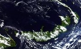
All Topics  
New Britain

 
New Britain

   Email Print
   Bookmark   Link


New Britain


New Britain is the largest island
Island

An island or isle is any piece of land that is surrounded by water. Very small islands such as emergent land features on atolls are called islets....
 in the Bismarck Archipelago
Bismarck Archipelago

The Bismarck Archipelago is a group of islands off the northeastern coast of New Guinea in the western Pacific Ocean and part of Papua New Guinea....
 (named for Otto von Bismarck
Otto von Bismarck

Otto Eduard Leopold von Bismarck, Count of Bismarck-Sch?nhausen, Duke of Lauenburg, Prince of Bismarck, , was a Kingdom of Prussia and Germany statesman and aristocrat of the 19th century....
) of Papua New Guinea
Papua New Guinea

Papua New Guinea , officially the Independent State of Papua New Guinea, is a country in Oceania, occupying the eastern half of the island of New Guinea and numerous offshore islands ....
. It is separated from the island of New Guinea
New Guinea

New Guinea, located just north of Australia, is the List of islands by area, having become separated from the Australian mainland when the area now known as the Torres Strait flooded after the last glacial period....
 by the Dampier Strait
Dampier Strait (Papua New Guinea)

Dampier Strait in Papua New Guinea separates Umboi Island and New Britain, linking the Bismarck Sea to the north with the Solomon Sea to the south, at ....
, and from New Ireland
New Ireland

New Ireland Province, formerly New Mecklenburg is the most northeastern Provinces of Papua New Guinea of Papua New Guinea....
 by the St. George's Channel. The main towns of New Britain are Rabaul
Rabaul

Rabaul is a township in East New Britain province, Papua New Guinea. The town was the provincial capital and most important settlement in the province until it was destroyed in 1994 by falling ash of a volcanic eruption....
/Kokopo
Kokopo

Kokopo is the capital of East New Britain in Papua New Guinea. The capital was moved from Rabaul in 1994 when the volcanoes Tavurvur and Vulcan erupted....
 and Kimbe
Kimbe

Kimbe is the capital of the province of West New Britain in Papua New Guinea. It is a port town on the great Kimbe Bay which boasts more than 60 percent of the coral species of the entire Indo-Pacific....
.

New Ireland
New Ireland (island)

New Ireland is a large island in Papua New Guinea, approximately 8,650 km? in area. It is the main and largest island of the New Ireland Province....
 and New Britain
New Britain

New Britain is the largest island in the Bismarck Archipelago of Papua New Guinea. It is separated from the island of New Guinea by the Dampier Strait , and from New Ireland by the St....
 islands get their names from the fact that their outlines on a map roughly correspond to those of the British Isles
British Isles

The British Isles are a group of islands off the northwest coast of continental Europe that include Great Britain and Ireland, and numerous smaller islands....
 in the Atlantic Ocean
Atlantic Ocean

The Atlantic Ocean is the second-largest of the world's oceanic divisions; with a total area of about 106.4 million square kilometres . It covers approximately one-fifth of the Earth's surface....
.

Britain extends from 148° to 152° E.


Discussion
Ask a question about 'New Britain'
Start a new discussion about 'New Britain'
Answer questions from other users
Full Discussion Forum


Recent Posts


Encyclopedia


New Britain is the largest island
Island

An island or isle is any piece of land that is surrounded by water. Very small islands such as emergent land features on atolls are called islets....
 in the Bismarck Archipelago
Bismarck Archipelago

The Bismarck Archipelago is a group of islands off the northeastern coast of New Guinea in the western Pacific Ocean and part of Papua New Guinea....
 (named for Otto von Bismarck
Otto von Bismarck

Otto Eduard Leopold von Bismarck, Count of Bismarck-Sch?nhausen, Duke of Lauenburg, Prince of Bismarck, , was a Kingdom of Prussia and Germany statesman and aristocrat of the 19th century....
) of Papua New Guinea
Papua New Guinea

Papua New Guinea , officially the Independent State of Papua New Guinea, is a country in Oceania, occupying the eastern half of the island of New Guinea and numerous offshore islands ....
. It is separated from the island of New Guinea
New Guinea

New Guinea, located just north of Australia, is the List of islands by area, having become separated from the Australian mainland when the area now known as the Torres Strait flooded after the last glacial period....
 by the Dampier Strait
Dampier Strait (Papua New Guinea)

Dampier Strait in Papua New Guinea separates Umboi Island and New Britain, linking the Bismarck Sea to the north with the Solomon Sea to the south, at ....
, and from New Ireland
New Ireland

New Ireland Province, formerly New Mecklenburg is the most northeastern Provinces of Papua New Guinea of Papua New Guinea....
 by the St. George's Channel. The main towns of New Britain are Rabaul
Rabaul

Rabaul is a township in East New Britain province, Papua New Guinea. The town was the provincial capital and most important settlement in the province until it was destroyed in 1994 by falling ash of a volcanic eruption....
/Kokopo
Kokopo

Kokopo is the capital of East New Britain in Papua New Guinea. The capital was moved from Rabaul in 1994 when the volcanoes Tavurvur and Vulcan erupted....
 and Kimbe
Kimbe

Kimbe is the capital of the province of West New Britain in Papua New Guinea. It is a port town on the great Kimbe Bay which boasts more than 60 percent of the coral species of the entire Indo-Pacific....
.

New Ireland
New Ireland (island)

New Ireland is a large island in Papua New Guinea, approximately 8,650 km? in area. It is the main and largest island of the New Ireland Province....
 and New Britain
New Britain

New Britain is the largest island in the Bismarck Archipelago of Papua New Guinea. It is separated from the island of New Guinea by the Dampier Strait , and from New Ireland by the St....
 islands get their names from the fact that their outlines on a map roughly correspond to those of the British Isles
British Isles

The British Isles are a group of islands off the northwest coast of continental Europe that include Great Britain and Ireland, and numerous smaller islands....
 in the Atlantic Ocean
Atlantic Ocean

The Atlantic Ocean is the second-largest of the world's oceanic divisions; with a total area of about 106.4 million square kilometres . It covers approximately one-fifth of the Earth's surface....
.

Geography

New Britain extends from 148° to 152° E. longitude and from 4° to 7° S. latitude. It is crescent-shaped, approximately 600 km (370 miles) along its southeastern coastline, and from 30 to 110 km (20–70 miles) wide, not including a small central peninsula. The island is the 38th largest in the world
List of islands by area

This is a list of islands in the world ordered by area. It includes all islands with an area greater than 2,500 km? , and several other islands over 500 km? ....
, with an area of 37,800 km² (14,600 mile²
Square mile

The square mile is an Imperial system and US customary system of measure for an area equal to the area of a square of one mile. It should not be confused with miles square, which refers to the number of miles on each side squared....
).

Steep cliffs form some sections of the coastline; in others the mountains are further inland, and the coastal area is flat and bordered by coral reefs. The highest point, at 2438 m (7999 ft), is Mount Sinewit in the Baining range
Baining Mountains

Baining Mountains is a mountain range on Gazelle Peninsula, New Britain, Papua New Guinea, at about . Highest point of the mountains is Mount Sinewit ....
 in the east. Most of the terrain is covered with tropical rainforest, and several large rivers are fed by the high rainfall.

New Britain was largely formed by volcanic processes, and there are several active volcanoes on the island, including Ulawun
Ulawun

Ulawun is a stratovolcano situated on the island of New Britain, Papua New Guinea, about 130 km southwest of Rabaul. It is the highest mountain in the Bismarck Archipelago, and one of the most active volcanoes in Papua New Guinea....
 (the highest volcano in Papua New Guinea), Langila
Langila

Langila is one of the most active volcanoes of New Britain, Papua New Guinea. It consists of four overlapping volcanic cones on the eastern flank of an older extinct volcano, Talawe....
, the Garbuna Group
Garbuna Group

The Garbuna Group of volcanoes consists of three volcanic peaks, Krummel, Garbuna, and Welcker, atop a shield volcano. They are located at the southern end of the Willaumez Peninsula, just to the west of the town of Kimbe, in West New Britain, Papua New Guinea....
, the Sulu Range
Sulu Range

The Sulu Range consists of a group of overlapping small stratovolcanos on the island of New Britain in Papua New Guinea. The highest point in Mount Malopu at the southwestern end of the complex....
, and the volcanoes Tavurvur
Tavurvur

Tavurvur is an active stratovolcano near Rabaul in East New Britain province, Papua New Guinea. It is a sub-vent of the Rabaul caldera and lies on the eastern rim of the larger feature....
 and Vulcan
Vulcan (volcano)

Vulcan is a pumice cone in Papua New Guinea. It is a sub-vent of the Rabaul caldera and lies on the western rim of the larger feature. Its most recent eruption was in 1994, when in conjunction with another vent, Tavurvur, the eruptions of Vulcan forced the abandonment of the city of Rabaul and the relocation of the local administrative cent...
 of the Rabaul caldera
Rabaul caldera

Rabaul caldera is a large volcano situated in East New Britain, Papua New Guinea. It derives its name from the town of Rabaul situated inside the caldera....
. A major eruption of Tavurvur in 1994 destroyed the East New Britain
East New Britain

East New Britain is a province of Papua New Guinea, on the island of New Britain. The capital of the province is Kokopo, not far from the old capital of Rabaul, which was largely destroyed in a 1994 volcanic eruption....
 provincial capital of Rabaul
Rabaul

Rabaul is a township in East New Britain province, Papua New Guinea. The town was the provincial capital and most important settlement in the province until it was destroyed in 1994 by falling ash of a volcanic eruption....
. Most of the town still lies under metres of ash, and the capital has been moved to nearby Kokopo
Kokopo

Kokopo is the capital of East New Britain in Papua New Guinea. The capital was moved from Rabaul in 1994 when the volcanoes Tavurvur and Vulcan erupted....
.

Administrative divisions


New Britain is part of the Islands Region, one of four regions of Papua New Guinea
Regions of Papua New Guinea

The four regions of Papua New Guinea are its broadest scale administrative divisions. While the twenty Provinces of Papua New Guinea are the primary administrative divisions of the country, the regions are quite significant in daily life, as they are often the basis for organisation of government services , corporate operations, sporting com...
. It comprises the mainland of two province
Province

A province is a territorial unit, almost always an administrative division, within a country or state....
s:
  • East New Britain
    East New Britain

    East New Britain is a province of Papua New Guinea, on the island of New Britain. The capital of the province is Kokopo, not far from the old capital of Rabaul, which was largely destroyed in a 1994 volcanic eruption....
     with headquarters in Kokopo
    Kokopo

    Kokopo is the capital of East New Britain in Papua New Guinea. The capital was moved from Rabaul in 1994 when the volcanoes Tavurvur and Vulcan erupted....
     (formerly Rabaul)
  • West New Britain
    West New Britain

    West New Britain is a province of Papua New Guinea on the islands of New Britain. The provincial capital is Kimbe. The area of the province in 21,000 km?, and there are 184,508 inhabitants ....
     with headquarters in Kimbe
    Kimbe

    Kimbe is the capital of the province of West New Britain in Papua New Guinea. It is a port town on the great Kimbe Bay which boasts more than 60 percent of the coral species of the entire Indo-Pacific....


History


1700-1914

William Dampier
William Dampier

William Dampier was an England buccaneer, sea captain, author and scientific observer. He was the first Englishman to explore or map parts of New Holland and New Guinea....
 became the first known European to visit New Britain on February 27, 1700: he dubbed the island with the Latin name Nova Britannia.

In November 1884, Germany proclaimed its protectorate
Protectorate

A protectorate, in international law, is an autonomous territory that is protected diplomatically or militarily against third parties by a stronger state or entity, in exchange for which the protectorate usually accepts specified obligations, which may vary greatly, depending on the real nature of their relationship....
 over the New Britain Archipelago; the German colonial administration gave New Britain and New Ireland
New Ireland (island)

New Ireland is a large island in Papua New Guinea, approximately 8,650 km? in area. It is the main and largest island of the New Ireland Province....
 the names of Neupommern (or Neu-Pommern; "New Pomerania
Pomerania

Pomerania is a historical region on the south coast of the Baltic Sea. Divided between Germany and Poland, it stretches roughly from the Recknitz River near Stralsund in the West, via the Oder River delta near Szczecin, to the mouth of the Vistula River near Gdansk in the East....
") and Neumecklenburg
New Ireland (island)

New Ireland is a large island in Papua New Guinea, approximately 8,650 km? in area. It is the main and largest island of the New Ireland Province....
 (or Neu-Mecklenburg; "New Mecklenburg
Mecklenburg

Mecklenburg is a region in northern Germany comprising the western and larger part of the federal state Mecklenburg-Vorpommern. The largest cities of the region are Rostock, Schwerin, and Neubrandenburg....
"), and the whole group was renamed the Bismarck Archipelago. New Britain became part of German New Guinea
German New Guinea

German New Guinea was a former Germany protectorate from 1884 to 1914, consisting of the northeastern part of New Guinea and several nearby island groups....
.

In 1909, the indigenous population was estimated at about 190,000; the foreign population at 773 (474 white). The expatriate population was practically confined to the northeastern Gazelle Peninsula, which included the capital, Herbertshöhe
Kokopo

Kokopo is the capital of East New Britain in Papua New Guinea. The capital was moved from Rabaul in 1994 when the volcanoes Tavurvur and Vulcan erupted....
 (now Kokopo). At the time 5,448 hectares (13,464 acres) had been converted to plantations, primarily copra, cotton, coffee, and rubber. Westerners avoided exploring the interior initially, believing that the indigenous peoples were warlike and would fiercely resist intrusions.

On 11 September 1914, New Britain became the site of one of the earliest battles of World War I
World War I

World War I, or the First World War , was a global military conflict which involved the Great powers, organized into two opposing military alliances: the Allies of World War I and the Central Powers....
 when the Australian Naval and Military Expeditionary Force
Australian Naval and Military Expeditionary Force

The Australian Naval and Military Expeditionary Force was a small volunteer force of approximately 2,000 men, raised in Australia shortly after the outbreak of the World War I to seize and destroy Germany wireless telegraphy stations in German New Guinea in the south-west Pacific Ocean....
 landed on the island. They quickly overwhelmed the German forces and German New Guinea became the Australian Territory of New Guinea.

World War II

During World War II
World War II

World War II, or the Second World War , was a global military conflict which involved a Participants in World War II, including all of the great powers, organised into two opposing military alliances: the Allies of World War II and the Axis powers....
 the Japanese
Empire of Japan

The Empire of Japan was a Japanese political entity that existed during the period from the Meiji Restoration in 1868 until its defeat in World War II in 1945....
 captured New Britain very early on. During January 1942, Japanese heavily bombed Rabaul
Rabaul

Rabaul is a township in East New Britain province, Papua New Guinea. The town was the provincial capital and most important settlement in the province until it was destroyed in 1994 by falling ash of a volcanic eruption....
. On January 23, Japanese Marines landed by the thousands, starting the Battle of Rabaul
Battle of Rabaul (1942)

The Battle of Rabaul, on the island of New Britain, in the Australian Territory of New Guinea, in January and February 1942, represented a strategically-significant defeat of Allies of World War II forces by Empire of Japan, in the Pacific War of World War II....
. The Japanese used Rabaul as a heavy base until 1944. It was used as the key point for the failed invasion of Port Moresby
Port Moresby

||-||-||-||-||-||}Port Moresby , or Pot Mosbi in Tok Pisin, population 255,000 , is the Capital and largest city of Papua New Guinea ....
.

New Britain was invaded by the U.S. First Marine Division in the Cape Gloucester
Cape Gloucester

Cape Gloucester is a headland, in the northwest of the island of New Britain, Papua New Guinea, at . It was the site of the Battle of Cape Gloucester, part of Operation Cartwheel, in 1943....
 area of the very western end of the island, and also by U.S. Army soldiers at some other coastal points. As for Cape Gloucester, with its swamps and mosquitos, the Marines said that it was "worse than Guadalcanal
Guadalcanal

Guadalcanal is a 2,510-square mile island in the Pacific Ocean and a province of the Solomon Islands. The World War II Guadalcanal Campaign happened on and around the island....
".

The Allies were able to bypass attacking Rabaul by surrounding it with air and naval bases on surrounding islands and on New Britain itself Operation Cartwheel
Operation Cartwheel

Operation Cartwheel was a major military strategy for the Allies of World War II in the Pacific War of World War II. Cartwheel was a twin-axis of advance operation, aimed at militarily neutralizing the major Empire of Japanese base at Rabaul....
. The large neighboring island of New Ireland
New Ireland

New Ireland Province, formerly New Mecklenburg is the most northeastern Provinces of Papua New Guinea of Papua New Guinea....
 was bypassed altogether. The Rabaul air and naval base was abandoned by the Japanese in August 1945, and surrender by the Japanese followed on 2 September 1945 in Tokyo Bay
Tokyo Bay

is a bay in the southern Kanto region of Japan. Its old name was ....
.

Since 1945


People and culture

The indigenous people of New Britain fall into two main groups: the Papuans, who have inhabited the island for tens of thousands of years, and the Austronesians
Austronesian people

Austronesian people are a population group present in Oceania and Southeast Asia who speak, or had ancestors who spoke, one of the Austronesian languages....
, who arrived around two thousand years ago. There are around ten Papuan languages spoken and about forty Austronesian languages, as well as Tok Pisin
Tok Pisin

Tok Pisin is a creole language spoken throughout Papua New Guinea; in parts of Western, Gulf, Central, Oro and Milne Bay Provinces the use of Tok Pisin has a shorter history, and is less universal, especially among older people....
 and English
English language

English is a West Germanic language that originated in Anglo-Saxon England and has lingua franca status in many parts of the world as a result of the military, economic, scientific, political and cultural influence of the British Empire in the 18th, 19th and early 20th centuries and that of the United States from the mid 20th century onwa...
. The Papuan population is largely confined to the eastern third of the island and a couple of small enclaves in the central highlands. At Jacquinot Bay
Jacquinot Bay

Jacquinot Bay is a bay in East New Britain Province, southeastern New Britain, Papua New Guinea, at ....
, in the south-east, they live beside the beach where a waterfall crashes directly into the sea.

The population of New Britain was 404,873 in the 2000 census. Austronesian people make up the majority on the island. The major towns are Rabaul
Rabaul

Rabaul is a township in East New Britain province, Papua New Guinea. The town was the provincial capital and most important settlement in the province until it was destroyed in 1994 by falling ash of a volcanic eruption....
/Kokopo
Kokopo

Kokopo is the capital of East New Britain in Papua New Guinea. The capital was moved from Rabaul in 1994 when the volcanoes Tavurvur and Vulcan erupted....
 in East New Britain
East New Britain

East New Britain is a province of Papua New Guinea, on the island of New Britain. The capital of the province is Kokopo, not far from the old capital of Rabaul, which was largely destroyed in a 1994 volcanic eruption....
 and Kimbe
Kimbe

Kimbe is the capital of the province of West New Britain in Papua New Guinea. It is a port town on the great Kimbe Bay which boasts more than 60 percent of the coral species of the entire Indo-Pacific....
 in West New Britain
West New Britain

West New Britain is a province of Papua New Guinea on the islands of New Britain. The provincial capital is Kimbe. The area of the province in 21,000 km?, and there are 184,508 inhabitants ....
.

The traditional cultures of New Britain are diverse and complex. While the Tolai
Tolai

The Tolai are the indigenous people of the Gazelle Peninsula and the Duke of York Islands of East New Britain in the Islands Region of Papua New Guinea....
 of the Rabaul area of East New Britain have a matrilineal society, other groups are patrilineal in structure. There are numerous traditions which remain active today, such as the dukduk
Duk-Duk

Duk-Duk is a secret society, part of the traditional culture of the Tolai people of the Rabaul area of New Britain, the largest island in the Bismarck Archipelago of Papua New Guinea, in the South Pacific....
 secret society (also known as tubuan) in the Tolai area.

See also

  • Postage stamps of New Britain