

List of Sites of Special Scientific Interest in Tyne and Wear
Encyclopedia
Tyne and Wear
Tyne and Wear is a metropolitan county in north east England around the mouths of the Rivers Tyne and Wear. It came into existence as a metropolitan county in 1974 after the passage of the Local Government Act 1972...
, England
England
England is a country that is part of the United Kingdom. It shares land borders with Scotland to the north and Wales to the west; the Irish Sea is to the north west, the Celtic Sea to the south west, with the North Sea to the east and the English Channel to the south separating it from continental...
. In England, the body responsible for designating SSSIs is Natural England
Natural England
Natural England is the non-departmental public body of the UK government responsible for ensuring that England's natural environment, including its land, flora and fauna, freshwater and marine environments, geology and soils, are protected and improved...
, which chooses sites because of their flora
Plant
Plants are living organisms belonging to the kingdom Plantae. Precise definitions of the kingdom vary, but as the term is used here, plants include familiar organisms such as trees, flowers, herbs, bushes, grasses, vines, ferns, mosses, and green algae. The group is also called green plants or...
, fauna
Fauna
Fauna or faunæ is all of the animal life of any particular region or time. The corresponding term for plants is flora.Zoologists and paleontologists use fauna to refer to a typical collection of animals found in a specific time or place, e.g. the "Sonoran Desert fauna" or the "Burgess shale fauna"...
, geological
Geology
Geology is the science comprising the study of solid Earth, the rocks of which it is composed, and the processes by which it evolves. Geology gives insight into the history of the Earth, as it provides the primary evidence for plate tectonics, the evolutionary history of life, and past climates...
or physiographical features. Natural England took over the role of designating and managing SSSIs from English Nature
English Nature
English Nature was the United Kingdom government agency that promoted the conservation of wildlife, geology and wild places throughout England between 1990 and 2006...
in October 2006 when it was formed from the amalgamation of English Nature, parts of the Countryside Agency
Countryside Agency
The Countryside Agency in England was a statutory body set up in 1999 with the task of improving the quality of the rural environment and the lives of those living in it. The Agency was formed by merging the Countryside Commission and the Rural Development Commission...
and the Rural Development Service
Rural Development Service
The Rural Development Service was formerly part of the UK Government's Department for Environment, Food and Rural Affairs . It ceased to exist on 1 October 2006 following the creation of Natural England.- History :...
. Natural England, like its predecessor, uses the 1974-1996 county system
Metropolitan and non-metropolitan counties of England
Metropolitan and non-metropolitan counties are one of the four levels of subdivisions of England used for the purposes of local government outside Greater London. As originally constituted, the metropolitan and non-metropolitan counties each consisted of multiple districts, had a county council and...
with each area being called an Area of Search
Area of Search
Areas of Search are geographical areas used in the selection of Sites of Special Scientific Interest. In England these are largely based on the 1974–1996 administrative counties...
.
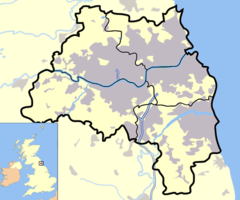
Tyne and Wear
Tyne and Wear
Tyne and Wear is a metropolitan county in north east England around the mouths of the Rivers Tyne and Wear. It came into existence as a metropolitan county in 1974 after the passage of the Local Government Act 1972...
is made up of five administrative local authorities consisting mainly of the two largest cities in the region: Newcastle-upon-Tyne and Sunderland, thus making it the sixth largest conurbation in the United Kingdom
United Kingdom
The United Kingdom of Great Britain and Northern IrelandIn the United Kingdom and Dependencies, other languages have been officially recognised as legitimate autochthonous languages under the European Charter for Regional or Minority Languages...
. Tyne and Wear shares its borders with Northumberland
Northumberland
Northumberland is the northernmost ceremonial county and a unitary district in North East England. For Eurostat purposes Northumberland is a NUTS 3 region and is one of three boroughs or unitary districts that comprise the "Northumberland and Tyne and Wear" NUTS 2 region...
and County Durham
County Durham
County Durham is a ceremonial county and unitary district in north east England. The county town is Durham. The largest settlement in the ceremonial county is the town of Darlington...
, to the north and south respectively.
List of sites
- Big Waters
- Boldon Pastures
- Brenkley Meadows
- Claxheugh Rock And Ford Limestone Quarry
- Cleadon Hill
- Dawson's Plantation Quarry
- Durham Coast
- Fulwell And Carley Hill Quarries
- GibsideGibsideGibside is a country estate near Rowlands Gill, Tyne and Wear, North East England that was previously owned by the Bowes-Lyon family. It is now a National Trust property. The main house on the estate is now a shell, although the property is most famous for its chapel...
- Gilleylaw Quarry
- Gosforth ParkGosforth ParkGosforth Park is a park north of Gosforth in the borough of Newcastle upon Tyne, England. It houses Newcastle Racecourse, a Marriott hotel, two golf courses, a garden centre and a football centre....
- Hallow Hill
- Harton Down Hill
- Hastings Hill
- Herrington HillHerrington HillHerrington Hill is a hill on the east side of Lavoisier Island, Biscoe Islands, about 5 nautical miles southward of Benedict Point. Mapped from air photos taken by Falkland Islands and Dependencies Aerial Survey Expedition . Named by United Kingdom Antarctic Place-Names Committee for Lovic P...
- Hetton Bogs
- High Haining Hill
- High MoorsleyHigh MoorsleyHigh Moorsley is a small village south-west of Hetton-le-Hole in the City of Sunderland, north east England.It is the site of the first weather radar system in the north-east of England, officially opened in July 2009....
- Humbledon Hill Quarry
- Hylton Castle Cutting
- Joe's PondJoe's Pond-Overview:Joe's Pond is a four hectare Site of Special Scientific Interest that lies to the east of, and adjacent to, the Rainton Meadows nature reserve. It was originally notified, as Nicholson’s Pond, in 1968...
- Lower Derwent Meadows
- Moorsley Banks
- Northumberland Shore
- Pockerley Farm Pond
- Prestwick CarrPrestwick CarrPrestwick Carr is an area of meadow and farmland and a Site of Special Scientific Interest known for its bird of prey population, it is situated east of Ponteland in Northumberland, North England.- References :*...
- Ridley Gill
- Ryton WillowsRyton, Tyne and WearRyton is a semi-rural small town near the western border of Tyne and Wear, England. Once an independent town in County Durham it became incorporated into the metropolitan county of Tyne and Wear and the Metropolitan Borough of Gateshead in 1974. It has a population of 15,742.- Location :Ryton lies...
, - Shibdon Pond
- South Hylton Pasture
- Strother Hills
- Thornley Wood
- Tunstall Hills And Ryhope Cutting
- Tynemouth To Seaton Sluice
- Wear River Bank
- West Farm Meadow, Boldon