

List of Pennsylvania state historical markers in Adams County
Encyclopedia
Pennsylvania state historical markers in Adams County by the Pennsylvania Historical and Museum Commission
Pennsylvania Historical and Museum Commission
The Pennsylvania Historical and Museum Commission is the governmental agency of the Commonwealth of Pennsylvania responsible for the collection, conservation and interpretation of Pennsylvania's historic heritage...
(PHMC) are 44 signs, including 16 regarding the Gettysburg Campaign
Gettysburg Campaign
The Gettysburg Campaign was a series of battles fought in June and July 1863, during the American Civil War. After his victory in the Battle of Chancellorsville, Confederate General Robert E. Lee's Army of Northern Virginia moved north for offensive operations in Maryland and Pennsylvania. The...
.
Historical markers
| Marker title | Image | Date dedicated | Location | Marker type | Topics |
|---|---|---|---|---|---|
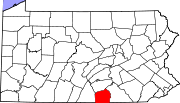
| Adams County Adams County, Pennsylvania Adams County is a county in the U.S. state of Pennsylvania. As of the 2010 census, the population was 101,407. It was created on January 22, 1800, from part of York County and named in honor of the second President of the United States, John Adams... |
Old Courthouse, Baltimore & W. Middle Sts. (Bus. 15 & PA 116), Gettysburg 39.82963°N 77.23132°W |
City | Abraham Lincoln, Agriculture, Civil War, Government & Politics, Government & Politics 19th Century | ||
| Christ Reformed Church | Hanover & Christ Church Rds. (PA 194 & SR 2023), 1.1 miles NE of Littlestown 39.75374°N 77.05745°W |
Roadside | Buildings, Early Settlement, Ethnic & Immigration, Religion | ||
| Conewago Chapel Conewago Chapel Conewago Chapel is a historic chapel in Hanover, Pennsylvania.It was built in 1787 and added to the National Register of Historic Places in 1975.... |
U.S. 30 W of New Oxford 39.86151°N 77.06869°W |
Roadside | Buildings, Religion | ||
| Daniel Alexander Payne | 239 N. Washington St. at Gettysburg College 39.83448°N 77.23333°W |
City | African American, Education, Religion | ||
| Dobbin House | Business U.S. 15 (Steinwehr Ave.) near Pa. 134, Gettysburg 39.822°N 77.23228°W |
Roadside | Buildings, Education | ||
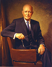
| Dwight D. Eisenhower Dwight D. Eisenhower Dwight David "Ike" Eisenhower was the 34th President of the United States, from 1953 until 1961. He was a five-star general in the United States Army... |
 |
157 N. Washington St., Gettysburg 39.83326°N 77.23356°W |
City | Government & Politics, Government & Politics 20th Century, Houses & Homesteads, Military, Military Post-Civil War | |
| Eddie Plank Eddie Plank Edward Stewart Plank , nicknamed "Gettysburg Eddie", was a Major League Baseball pitcher. He is the first left-handed pitcher to win 200 games and then 300 games, and now ranks third in all-time wins among left-handers with 326 career victories and first all-time in career shutouts by a... |
intersection of Carlisle St. & West Lincoln Ave., Gettysburg 39.83635°N 77.23134°W |
Roadside | Baseball, Sports | ||
| Field Hospital Field hospital A field hospital is a large mobile medical unit that temporarily takes care of casualties on-site before they can be safely transported to more permanent hospital facilities... |
Pa. 116 (Main St.) at St. John Lutheran Church, Fairfield 39.78739°N 77.36883°W |
City | Civil War, Medicine & Science, Military | ||
| Gettys Crossroads and Tavern | 44 York St., Gettysburg 39.83091°N 77.22953°W |
City | American Revolution, Business, Roads, Inns & Taverns, Transportation | ||
| Gettysburg Address Gettysburg Address The Gettysburg Address is a speech by U.S. President Abraham Lincoln and is one of the most well-known speeches in United States history. It was delivered by Lincoln during the American Civil War, on the afternoon of Thursday, November 19, 1863, at the dedication of the Soldiers' National Cemetery... |
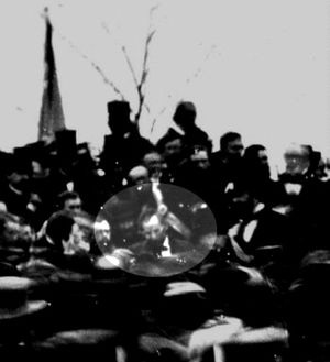 |
PA 134 (Taneytown Rd.) at entrance to National Cemetery 39.8177°N 77.23245°W |
Roadside | Abraham Lincoln, Civil War, Government & Politics, Government & Politics 19th Century, Military | |
| Gettysburg Address Gettysburg Address The Gettysburg Address is a speech by U.S. President Abraham Lincoln and is one of the most well-known speeches in United States history. It was delivered by Lincoln during the American Civil War, on the afternoon of Thursday, November 19, 1863, at the dedication of the Soldiers' National Cemetery... |
|
Baltimore St. (old US 140) & PA 134 at entrance to National Cemetery 39.82149°N 77.22957°W |
Roadside | Abraham Lincoln, Civil War, Government & Politics, Government & Politics 19th Century | |
| Gettysburg Campaign Gettysburg Campaign The Gettysburg Campaign was a series of battles fought in June and July 1863, during the American Civil War. After his victory in the Battle of Chancellorsville, Confederate General Robert E. Lee's Army of Northern Virginia moved north for offensive operations in Maryland and Pennsylvania. The... |
Rt. 30 & Calvary Field Rd., east of Gettysburg 39.84834°N 77.18249°W |
Roadside | Civil War, Military | ||
| Gettysburg Campaign | 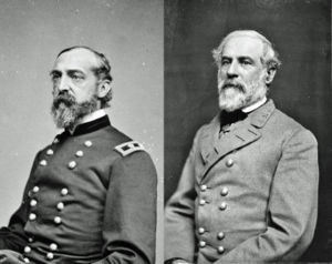 |
Fairfield Rd. (PA 116), near Bream's Mill Rd., W of Gettysburg °N °W |
Roadside | Civil War, Military | |
| Gettysburg Campaign | PA 394 just west of PA 94, Hampton 39.92926°N 77.05856°W |
Roadside | Civil War, Military | ||
| Gettysburg Campaign | Old Rte. 30 just west of SR 3011, north of Cashtown 39.88469°N 77.36048°W |
Roadside | Civil War, Military | ||
| Gettysburg Campaign | Pa. 134, .7 mile north of state line 39.72954°N 77.21054°W |
Roadside | Civil War, Military | ||
| Gettysburg Campaign | SR 3001 (old US 15) just south of Rt. 234, Heidlersburg 39.94713°N 77.14734°W |
Roadside | Civil War, Military | ||
| Gettysburg Campaign | Baltimore Pike (US 97), 2 miles SE of Gettysburg 39.80444°N 77.20972°W |
Roadside | Civil War, Military | ||
| Gettysburg Campaign | PA 134 at SR 1002 (Taneytown & Barlow-Greenmount Rds.) at Barlow Fire Co. (new location in 2008) Barlow, Pennsylvania Barlow, Pennsylvania is a populated place between the Gettysburg Battlefield and the Mason-Dixon Line at the intersection of Rock Creek and Pennsylvania Route 134. North of the creek on the road summit is the principal facility of the rural community: the 1939 community hall at the fire station... 39.7622°N 77.23235°W |
Roadside | Civil War, Military | ||
| Gettysburg Campaign | Old US 15 near Marsh Creek, S of Greenmount 39.74833°N 77.28302°W |
Roadside | Civil War, Military | ||
| Gettysburg Campaign | SR 3001 (old Rt. 15), just north of Heidlersburg 39.95424°N 77.14378°W |
Roadside | Civil War, Military | ||
| Gettysburg Campaign | Herrs Ridge & Biglerville (PA 34) Rds., 3 miles N of Gettysburg 39.84846°N 77.24387°W |
Roadside | Civil War, Military | ||
| Gettysburg Campaign | n/a | US 30 just east of PA 94 junction, east of New Oxford 39.86958°N 77.03123°W |
Roadside | Civil War, Military | |
| Gettysburg Campaign | |
US 30 at W approach to Gettysburg 39.83769°N 77.2515°W |
Roadside | Civil War, Military | |
| Gettysburg Campaign | n/a | U.S. 30 just W of PA 94 junction, E of New Oxford 39.87296°N 77.02246°W |
Roadside | Civil War, Military | |
| John Hanson "Hance" Steelman (1655-1749) - PLAQUE | SW corner intersection of Steelman Marker Rd., Crum Rd. (T-111), & Topper Rd. (T-312), just E of Zora 39.73498°N 77.36029°W |
Plaque | Early Settlement, Ethnic & Immigration, Native American | ||
| John Hanson Steelman | Near Pa. 16 & Pa. 116 junction, betw. Zora & state line (Missing) °N °W |
Roadside | Early Settlement, Ethnic & Immigration, Native American, Professions & Vocations, William Penn | ||
| John Studebaker John Studebaker John Mohler Studebaker was the German-American co-founder and later executive of what would become the Studebaker Corporation automobile company... |
 |
Oxford Rd. (SR 1015), just off PA 234, 1/2 mile E of Heidlersburg 39.56906°N 77.07901°W |
Roadside | Business & Industry, Entrepreneurs, Transportation | |
| Lincoln Cemetery | Intersection of Lincoln & Long Lanes, Gettysburg 39.82616°N 77.23575°W |
Roadside | African American, Civil War, Military, Military Post-Civil War | ||
| Lower Marsh Creek Church | PA 116 & SR 3013 (Knoxlyn Rd.), 4 miles W of Gettysburg 39.81061°N 77.3211°W |
Roadside | Buildings, Religion | ||
| Manor of Maske | U.S. 30 at E end of Gettysburg 39.83576°N 77.21736°W |
Roadside | Buildings, Mansions & Manors, William Penn | ||
| Manor of Maske | U.S. 30 near SR 1077, W of Seven Stars 39.86488°N 77.31337°W |
Roadside | Buildings, Mansions & Manors, William Penn | ||
| Mary Jemison Mary Jemison Mary Jemison was an American frontierswoman and an adopted Seneca. When she was in her teens, she was captured in what is now Adams County, Pennsylvania, from her home along Marsh Creek, and later chose to remain a Seneca.... |
U.S. 30 at PA 234 junction, 4 miles W of Cashtown 39.89749°N 77.43612°W |
Roadside | French & Indian War, Native American, Women | ||
| Old Courthouse Old Courthouse The Old St. Louis County Courthouse was built as a combination federal and state courthouse in St. Louis, Missouri. Missouri's tallest habitable building from 1864 to 1894, it is now part of the Jefferson National Expansion Memorial and operated by the National Park Service used for historical... |
SW section of Square, York (Rt. 30) & Baltimore Sts., Gettysburg 39.83093°N 77.23087°W |
City | Government & Politics, Government & Politics 19th Century | ||
| Pennsylvania Pennsylvania The Commonwealth of Pennsylvania is a U.S. state that is located in the Northeastern and Mid-Atlantic regions of the United States. The state borders Delaware and Maryland to the south, West Virginia to the southwest, Ohio to the west, New York and Ontario, Canada, to the north, and New Jersey to... |
 |
U.S. 15, 200 yards from state line 39.71984°N 77.3065°W |
Roadside | Government & Politics, Government & Politics 17th Century, William Penn | |
| Pennsylvania Pennsylvania The Commonwealth of Pennsylvania is a U.S. state that is located in the Northeastern and Mid-Atlantic regions of the United States. The state borders Delaware and Maryland to the south, West Virginia to the southwest, Ohio to the west, New York and Ontario, Canada, to the north, and New Jersey to... |
|
US 97 at Mathias Rd., .4 mile from state line (MISSING) °N °W |
Roadside | Government & Politics, Government & Politics 17th Century, William Penn | |
| Rock Chapel | SR 3001 / Old US 15 (Old Harrisburg Rd.) & SR 1016 (Oxford Rd.), N of Heidlersburg 39.96082°N 77.14032°W |
Roadside | Buildings, Religion | ||
| Rural Electrification Rural electrification Rural electrification is the process of bringing electrical power to rural and remote areas. Electricity is used not only for lighting and household purposes, but it also allows for mechanization of many farming operations, such as threshing, milking, and hoisting grain for storage; in areas... |
Pa. 34 near Palace Dr., 1.7 miles N of Gettysburg 39.86307°N 77.23836°W |
Roadside | Business & Industry, Electricity | ||
| Russell Tavern | Pa. 34 at Goldenville Rd., 4 miles N of Gettysburg (MISSING) 39.89217°N 77.24621°W |
Roadside | Buildings, Business & Industry, George Washington, Military, Inns & Taverns, Whiskey Rebellion | ||
| Sachs Covered Bridge Sachs Covered Bridge The Sachs Covered Bridge , also known as Sauck's Covered Bridge and Waterworks Covered Bridge, is a , Town truss covered bridge over Marsh Creek between Cumberland and Freedom Townships, Adams County in the U.S. state of Pennsylvania. The bridge was also known as the Sauches Covered Bridge at the... |
Pumping Station Rd. (SR 3005) & Waterworks Rd., SW of Eisenhower Nat'l. Hist site, Gettysburg 39.79856°N 77.27915°W |
Roadside | Bridges, Civil War, Transportation | ||
| Studebaker Home | 200 W. King St. (PA 234) W of Abbottstown St. (PA 194), East Berlin 39.93912°N 76.98063°W |
City | Buildings, Houses & Homesteads, Professions & Vocations, Religion | ||
| Tapeworm Railroad Tapeworm Railroad The Tapeworm Railroad was a railway line planned by Thaddeus Stevens and nicknamed by opponents ridiculing a lengthy serpentine section around the Green Ridge of South Mountain... |
Fairfield Rd. (PA 116) & Iron Springs Rd. (SR 3014), SW of Fairfield 39.78133°N 77.37821°W |
Roadside | Railroads, Transportation | ||
| Thaddeus Stevens Thaddeus Stevens Thaddeus Stevens , of Pennsylvania, was a Republican leader and one of the most powerful members of the United States House of Representatives... |
51 Chambersburg St., Gettysburg 39.83097°N 77.23276°W |
City | African American, Business & Industry, Education, Government & Politics, Iron | ||
| Wills House | SE section of Square, York St. (Rt. 30) & Baltimore/Carlisle St. (Rt. 116), Gettysburg 39.83077°N 77.23085°W |
City | Government & Politics, Government & Politics 19th Century, Houses & Homesteads |
See also
- List of Pennsylvania state historical markers
- National Register of Historic Places listings in Adams County, PennsylvaniaNational Register of Historic Places listings in Adams County, PennsylvaniaThis is a list of the National Register of Historic Places listings in Adams County, Pennsylvania.This is intended to be a complete list of the properties and districts on the National Register of Historic Places in Adams County, Pennsylvania, United States...