

List of National Natural Landmarks in Oregon
Encyclopedia
From List of National Natural Landmarks, these are the National Natural Landmark
s in the U.S. state
of Oregon
.
National Natural Landmark
The National Natural Landmark program recognizes and encourages the conservation of outstanding examples of the natural history of the United States. It is the only natural areas program of national scope that identifies and recognizes the best examples of biological and geological features in...
s in the U.S. state
U.S. state
A U.S. state is any one of the 50 federated states of the United States of America that share sovereignty with the federal government. Because of this shared sovereignty, an American is a citizen both of the federal entity and of his or her state of domicile. Four states use the official title of...
of Oregon
Oregon
Oregon is a state in the Pacific Northwest region of the United States. It is located on the Pacific coast, with Washington to the north, California to the south, Nevada on the southeast and Idaho to the east. The Columbia and Snake rivers delineate much of Oregon's northern and eastern...
.
| # | Name | Image | Date | Location | County | Description |
|---|---|---|---|---|---|---|
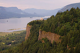
| 1 | Crown Point Crown Point (Oregon) Crown Point is the name of a promontory on the Columbia River Gorge and an associated state park in the U.S. state of Oregon. It is located in eastern Multnomah County, approximately 15 miles east of Portland. Crown Point is one of the scenic lookouts along the Historic Columbia River Highway,... |
 |
1971 | 45.5395°N 122.24422°W | Multnomah Multnomah County, Oregon Multnomah County is one of 36 counties in the U.S. state of Oregon. Though smallest in area, it is the most populous as its county seat, Portland, is the state's largest city... |
Promontory Promontory Promontory may refer to:*Promontory, a prominent mass of land which overlooks lower lying land or a body of water*Promontory, Utah, the location where the United States first Transcontinental Railroad was completed... in Columbia Gorge |
| 2 | Fort Rock State Monument | 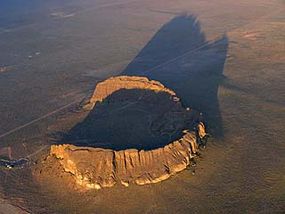 |
1976 | 43.372°N 121.074°W | Lake Lake County, Oregon Lake County is a county in the high desert south central region of the U.S. state of Oregon, so named for the many lakes found within its boundaries, including Lake Abert, Hart Lake Reservoir, and Goose Lake. While Lake is among Oregon's largest counties, it is sparsely populated with 7,895... |
Volcanic tuff ring |
| 3 | Horse Ridge Natural Area | 1967 | 43.924°N 121.039°W | Deschutes Deschutes County, Oregon -National protected areas:* Deschutes National Forest * Newberry National Volcanic Monument-Demographics:As of the census of 2000, there were 115,367 people, 45,595 households, and 31,962 families residing in the county. The population density was 38 people per square mile . There were 54,583... |
Park | |
| 4 | Lawrence Memorial Grassland Preserve | 1984 | Oregon | An excellent illustration of "biscuit and scabland" topography. | ||
| 5 | Willamette Floodplain Willamette Floodplain The Willamette Floodplain consists of of natural grassland that was made a National Natural Landmark near the Willamette River in May 1987. The floodplain is within the William L... |
1987 | 44.364°N 123.23°W | Benton Benton County, Oregon -National protected areas:*Siuslaw National Forest *William L. Finley National Wildlife Refuge-Demographics:As of the census of 2000, there were 78,153 people, 30,145 households, and 18,237 families residing in the county. The population density was 116 people per square mile . There were 31,980... , Lane Lane County, Oregon -National protected areas:*Oregon Islands National Wildlife Refuge *Siuslaw National Forest *Umpqua National Forest *Willamette National Forest -Government:... , Linn Linn County, Oregon Linn County is a county located in the U.S. state of Oregon. It is named in honor of Lewis F. Linn, a U.S. Senator from Missouri who advocated the American occupation of the Oregon Country. By the 2010 US census the population of Linn county was 116,672 showing a 13.2% growth since the 2000 census... , Marion Marion County, Oregon Marion County is a county located in the U.S. state of Oregon. It was originally named the Champooick District, after Champoeg, a meeting place on the Willamette River. On September 3, 1849, the territorial legislature renamed it in honor of Francis Marion, a Continental Army general of the... , Polk Polk County, Oregon Polk County is a county located in the U.S. state of Oregon. The county is named for James Knox Polk, the 11th president of the United States. In 2010, its population was 75,403. The seat of the county is Dallas.... |
Floodplain | |
| 6 | Newberry Crater | 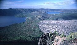 |
1976 | 43.689194°N 121.254889°W | Deschutes Deschutes County, Oregon -National protected areas:* Deschutes National Forest * Newberry National Volcanic Monument-Demographics:As of the census of 2000, there were 115,367 people, 45,595 households, and 31,962 families residing in the county. The population density was 38 people per square mile . There were 54,583... |
Atypical shield volcano |
| 7 | John Day Fossil Beds | 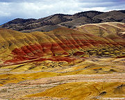 |
1966 | Grant Grant County, Oregon Grant County is a county located in the U.S. state of Oregon. It is included in the 8 county definition of Eastern Oregon. In 2010, its population was 7,445. It is named for President Ulysses S. Grant, who served as an army officer in the Oregon Territory, and at the time of the county's creation... |
Contains a remarkable sequence of very diverse fossils. |