
List of National Historic Landmarks in North Dakota
Encyclopedia
The List of National Historic Landmarks in North Dakota contains the landmarks designated by the U.S. Federal Government for the U.S. state
of North Dakota
.
There are 6 National Historic Landmark
s (NHLs) in North Dakota.
Also included is a National Historic Site that is not also NHL-designated.
Fort Union Trading Post National Historic Site
is also an NHL and is listed above. The other one is:
U.S. state
A U.S. state is any one of the 50 federated states of the United States of America that share sovereignty with the federal government. Because of this shared sovereignty, an American is a citizen both of the federal entity and of his or her state of domicile. Four states use the official title of...
of North Dakota
North Dakota
North Dakota is a state located in the Midwestern region of the United States of America, along the Canadian border. The state is bordered by Canada to the north, Minnesota to the east, South Dakota to the south and Montana to the west. North Dakota is the 19th-largest state by area in the U.S....
.
There are 6 National Historic Landmark
National Historic Landmark
A National Historic Landmark is a building, site, structure, object, or district, that is officially recognized by the United States government for its historical significance...
s (NHLs) in North Dakota.
Also included is a National Historic Site that is not also NHL-designated.
Current National Historic Landmarks
| Landmark name | Image | Date declared | Locality |
County | Description | |
|---|---|---|---|---|---|---|
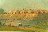
| Big Hidatsa Village Site Big Hidatsa Village Site Big Hidatsa Village Site is a Mercer County, North Dakota site significant for its well-defined depressions left from Hidatsa and Mandan earth lodges. It is the largest of three villages preserved in Knife River Indian Villages National Historic Site.... |
 |
Stanton Stanton, North Dakota Stanton is a city in Mercer County, North Dakota in the United States. It is the county seat of Mercer County. The population was 366 at the 2010 census. Stanton was founded in 1883 and became the county seat when Mercer County organized in 1884.... |
Mercer Mercer County, North Dakota -Major highways:* North Dakota Highway 31* North Dakota Highway 48* North Dakota Highway 49* North Dakota Highway 200* North Dakota Highway 1806-Demographics:... |
Largest of 3 villages preserved in Knife River Indian Villages National Historic Site Knife River Indian Villages National Historic Site The Knife River Indian Villages National Historic Site, which was established in 1974, preserves the historic and archaeological remnants of the Northern Plains Indians. This area was a major trading and agricultural area. There were three villages that occupied the Knife area. In general, these... . |
||
| Fort Union Trading Post Fort Union Trading Post National Historic Site Fort Union Trading Post National Historic Site is the site of a partially reconstructed trading post on the Missouri River and the North Dakota/Montana border twenty-five miles from Williston. It is one of the earliest declared National Historic Landmarks of the United States... |
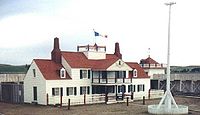 |
Buford Buford, North Dakota Buford is an unincorporated community in Williams County, North Dakota, United States. It is the nearest community to the Fort Union Trading Post National Historic Site.... |
Williams Williams County, North Dakota -Major highways:* U.S. Highway 2* U.S. Highway 85* North Dakota Highway 40* North Dakota Highway 50* North Dakota Highway 1804-National protected areas:* Fort Union Trading Post National Historic Site * Lake Zahl National Wildlife Refuge... |
Most important fur trading post on the upper Missouri until 1867. Visitors included John James Audubon John James Audubon John James Audubon was a French-American ornithologist, naturalist, and painter. He was notable for his expansive studies to document all types of American birds and for his detailed illustrations that depicted the birds in their natural habitats... , George Catlin George Catlin George Catlin was an American painter, author and traveler who specialized in portraits of Native Americans in the Old West.-Early years:... , Father Pierre DeSmet, Sitting Bull Sitting Bull Sitting Bull Sitting Bull Sitting Bull (Lakota: Tȟatȟáŋka Íyotake (in Standard Lakota Orthography), also nicknamed Slon-he or "Slow"; (c. 1831 – December 15, 1890) was a Hunkpapa Lakota Sioux holy man who led his people as a tribal chief during years of resistance to United States government policies... , Karl Bodmer Karl Bodmer Karl Bodmer was a Swiss painter of the American West. He accompanied German explorer Maximilian zu Wied-Neuwied from 1832 through 1834 on his Missouri River expedition... , and Jim Bridger Jim Bridger James Felix "Jim" Bridger was among the foremost mountain men, trappers, scouts and guides who explored and trapped the Western United States during the decades of 1820-1850, as well as mediating between native tribes and encroaching whites... . |
||
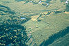
| Frederick A. and Sophia Bagg Bonanza Farm Frederick A. and Sophia Bagg Bonanza Farm Frederick A. and Sophia Bagg Bonanza Farm, also known as Bagg Bonanza Farm or F. A. Bagg Farm, is a bonanza farm in Richland County, North Dakota.It was declared a National Historic Landmark in 2005.... |
image pending | Mooreton Mooreton, North Dakota As of the census of 2000, there were 204 people, 92 households, and 49 families residing in the city. The population density was 769.7 people per square mile . There were 95 housing units at an average density of 358.5 per square mile . The racial makeup of the city was 98.04% White and 1.96%... |
Richland Richland County, North Dakota -History:Richland County wa formed in 1873. It was named for Morgan T. Rich, an early settler in the area.-Demographics:As of the census of 2000, there were 17,998 people, 6,885 households, and 4,427 families residing in the county. The population density was 12 people per square mile . There... |
Preserved bonanza farm. | ||
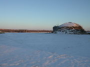
| Huff Archeological Site Huff Archeological Site Huff Archeological Site, also known as Huff State Historic Site, is a former fortified village of the Mandan, currently on the bank of Lake Oahe in North Dakota. It dates back to about 1450 AD, and perhaps a thousand or more people once lived there. The village was probably only occupied for... |
Huff Huff, North Dakota Huff is an unincorporated community in Morton County, North Dakota, United States. Huff is located about 20 miles south of Bismarck, North Dakota on the Missouri River at the top of Lake Oahe, a reservoir created by a dam. It is located on North Dakota Highway 1806. Huff is the nearest town to Huff... |
Morton Morton County, North Dakota -Demographics:As of the census of 2000, there were 25,303 people, 9,889 households, and 6,932 families residing in the county. The population density was 13 people per square mile . There were 10,587 housing units at an average density of 6 per square mile... |
Former fortified village of the Mandan, on the bank of Lake Oahe Lake Oahe Lake Oahe is a large reservoir behind Oahe Dam on the Missouri River beginning in central South Dakota and continuing north into North Dakota in the United States. The lake has an area of and a maximum depth of . By volume, it is the fourth-largest reservoir in the US. Lake Oahe has a length of... . Archaeological site Archaeological site An archaeological site is a place in which evidence of past activity is preserved , and which has been, or may be, investigated using the discipline of archaeology and represents a part of the archaeological record.Beyond this, the definition and geographical extent of a 'site' can vary widely,... , open to the public. |
|||
| Lynch Quarry Site | Address Restricted | Dunn Dunn County, North Dakota -Major highways:*North Dakota Highway 8*North Dakota Highway 22*North Dakota Highway 200-Demographics:As of the census of 2000, there were 3,600 people, 1,378 households, and 986 families residing in the county. The population density was 2 people per square mile . There were 1,965 housing units... |
||||
| Menoken Indian Village Site Menoken Indian Village Site Menoken Indian Village Site, also known as Menoken Site, Verendrye Site or Apple Creek Site is an archeological site in Bismarck, North Dakota. It was a village of earthen homes, and was occupied in the 13th century.... |
 |
Bismarck Bismarck, North Dakota Bismarck is the capital of the U.S. state of North Dakota and the county seat of Burleigh County. It is the second most populous city in North Dakota after Fargo. The city's population was 61,272 at the 2010 census, while its metropolitan population was 108,779... |
Burleigh Burleigh County, North Dakota -National protected areas:*Canfield Lake National Wildlife Refuge*Florence Lake National Wildlife Refuge*Long Lake National Wildlife Refuge -Demographics:... |
Site of village in 1200s CE Common Era Common Era ,abbreviated as CE, is an alternative designation for the calendar era originally introduced by Dionysius Exiguus in the 6th century, traditionally identified with Anno Domini .Dates before the year 1 CE are indicated by the usage of BCE, short for Before the Common Era Common Era... |
||
Historic areas of the NPS in North Dakota
National Historic Sites, National Historical Parks, some National Monuments, and certain other areas listed in the National Park system are historic landmarks of national importance that are highly protected already, often before the inauguration of the NHL program in 1960, and are then often not also named NHLs per se. There are two of these in North Dakota. The National Park Service lists these two together with the NHLs in the state,Fort Union Trading Post National Historic Site
Fort Union Trading Post National Historic Site
Fort Union Trading Post National Historic Site is the site of a partially reconstructed trading post on the Missouri River and the North Dakota/Montana border twenty-five miles from Williston. It is one of the earliest declared National Historic Landmarks of the United States...
is also an NHL and is listed above. The other one is:
| Landmark name | Image | Date established | Location | County | Description | |
|---|---|---|---|---|---|---|
| Knife River Indian Villages National Historic Site Knife River Indian Villages National Historic Site The Knife River Indian Villages National Historic Site, which was established in 1974, preserves the historic and archaeological remnants of the Northern Plains Indians. This area was a major trading and agricultural area. There were three villages that occupied the Knife area. In general, these... |
 |
Stanton Stanton, North Dakota Stanton is a city in Mercer County, North Dakota in the United States. It is the county seat of Mercer County. The population was 366 at the 2010 census. Stanton was founded in 1883 and became the county seat when Mercer County organized in 1884.... |
Mercer Mercer County, North Dakota -Major highways:* North Dakota Highway 31* North Dakota Highway 48* North Dakota Highway 49* North Dakota Highway 200* North Dakota Highway 1806-Demographics:... |
Three villages | ||