
List of Dublin bridges and tunnels
Encyclopedia
This article lists the bridges and tunnels in Dublin and the Greater Dublin Area
in Ireland
. The bridges are ordered sequentially upstream, from mouth to source
. Alternate or historical names are in curved bracket
s (parentheses). Traversing roads or rails are in square brackets.
in Greater Dublin, from east to west.
Bridges over the River Liffey
outside Greater Dublin, from east to west.
to the south and west. In addition, many of the canal locks
allow for pedestrian crossing.
from the River Liffey
to the north and west. Many of the bridges include a railroad crossing for railroads adjacent to the canal in much of Dublin. In addition, many of the canal locks
allow for pedestrian crossing and several pedestrian bridges are located adjacent to Iarnród Éireann
railway stations.
from the River Liffey
to the southwest.
from the River Liffey
to the northwest.
Greater Dublin Area
Greater Dublin Area , or simply Greater Dublin, is a term which is used to describe the city of Dublin and various counties in the hinterland of the city in Ireland. The term has no basis in law and no local government, department of government or agency of the state is bound by the term...
in Ireland
Republic of Ireland
Ireland , described as the Republic of Ireland , is a sovereign state in Europe occupying approximately five-sixths of the island of the same name. Its capital is Dublin. Ireland, which had a population of 4.58 million in 2011, is a constitutional republic governed as a parliamentary democracy,...
. The bridges are ordered sequentially upstream, from mouth to source
Source (river or stream)
The source or headwaters of a river or stream is the place from which the water in the river or stream originates.-Definition:There is no universally agreed upon definition for determining a stream's source...
. Alternate or historical names are in curved bracket
Bracket
Brackets are tall punctuation marks used in matched pairs within text, to set apart or interject other text. In the United States, "bracket" usually refers specifically to the "square" or "box" type.-List of types:...
s (parentheses). Traversing roads or rails are in square brackets.
Bridges over the Liffey
Bridges over the River LiffeyRiver Liffey
The Liffey is a river in Ireland, which flows through the centre of Dublin. Its major tributaries include the River Dodder, the River Poddle and the River Camac. The river supplies much of Dublin's water, and a range of recreational opportunities.-Name:The river was previously named An Ruirthech,...
in Greater Dublin, from east to west.
| Name | Alternate names | Type | Connections | Build dates | Image |
|---|---|---|---|---|---|
| East-Link Bridge East-Link (Dublin) The East-Link is a toll bridge in Dublin, Ireland, on the River Liffey, owned by Dublin City Council and operated by NTR plc. The lifting bridge, which links North Wall to Ringsend, is the last bridge on the Liffey, which opens out into Dublin Port and then Dublin Bay just beyond... |
Tolled drawbridge | East Wall Road to York road | 1987 | ||
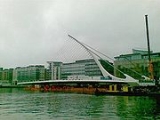
| Samuel Beckett Bridge Samuel Beckett Bridge Samuel Beckett Bridge is a cable-stayed bridge in Dublin that joins Sir John Rogerson's Quay on the south side of the River Liffey to Guild Street and North Wall Quay in the Docklands area.-Design and construction:... |
Rotatable road bridge | Guild Street to Sir John Rogerson's Quay | 2009 | 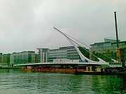 |
|
| Seán O'Casey Bridge Sean O'Casey Bridge Seán O'Casey Bridge is a pedestrian swingbridge spanning the River Liffey in Dublin, joining City Quay in the Grand Canal Docks area to North Wall Quay and the IFSC.... |
Footbridge | Sir John Rogerson's Quay to North Wall Quay | 2005 | 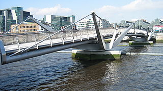 |
|
| Talbot Memorial Bridge Talbot Memorial Bridge The Talbot Memorial Bridge is a road bridge spanning the River Liffey in Dublin city centre in the Republic of Ireland. Completed in 1978, it is 22 metres wide, and was designed by De Leuw, Chadwick and O’hEocha Consulting Engineers.... |
Road bridge | Memorial Road to Moss Street | 1978 | ||
| Loopline Bridge Loopline Bridge The Loopline Bridge is a railway bridge spanning the River Liffey and several streets in Dublin, Ireland. It joins rail services from south of Dublin to Connolly Station and lines north.... |
Liffey Viaduct | Rail Bridge with overhead power supply for the DART Dublin Area Rapid Transit The Dublin Area Rapid Transit is part of the suburban railway network in Ireland, running mainly along the coastline of Dublin Bay on the Trans-Dublin route, from Greystones in County Wicklow, through Dublin to Howth and Malahide in County Dublin.Trains are powered via a 1500V DC overhead catenary... |
Links suburban and intercity rail lines south of Liffey to those in the north | 1891 | |
| Butt Bridge Butt Bridge Butt Bridge is a road bridge in Dublin, Ireland which spans the River Liffey and joins George's Quay to Beresford Place and the north quays at Liberty Hall.... |
Road bridge | Beresford Place to Tara Street | 1932 (Previous structure: 1879) | ||
| Unnamed bridge | Road bridge (public transport) | Marlborough Street Marlborough Street (Dublin) Marlborough Street, is a street in Dublin, Ireland. The current name is in honour of the Duke of Marlborough, known for his victory at Blenheim during the 18th century. In the late 19th century it was for a time called Tyrone Street after Tyrone House... to Hawkins Street |
2009 - 2011 (planned) | ||
| O'Connell Bridge O'Connell Bridge O'Connell Bridge is a road bridge spanning the River Liffey in Dublin, and joining O'Connell Street to D'Olier Street, Westmoreland Street and the south quays.-History:... |
Carlisle Bridge | Road bridge | O’Connell Street Lower O'Connell Street O'Connell Street is Dublin's main thoroughfare. It measures 49 m in width at its southern end, 46 m at the north, and is 500 m in length... to Westmoreland Street and D'Olier Street |
1791 (Original: 1791 Redeveloped: 1879) | 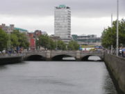 |
| Liffey Bridge Ha'penny Bridge The Ha'penny Bridge , known later for a time as the Penny Ha'penny Bridge, and officially the Liffey Bridge, is a pedestrian bridge built in 1816 over the River Liffey in Dublin, Ireland... |
Ha'penny Bridge Ha'penny Bridge The Ha'penny Bridge , known later for a time as the Penny Ha'penny Bridge, and officially the Liffey Bridge, is a pedestrian bridge built in 1816 over the River Liffey in Dublin, Ireland... , Metal Bridge, Wellington Bridge |
Foot bridge | Liffey Street Lower to Merchant's Arch | 1816 |  |
| Millennium bridge Millennium Bridge (Dublin) The Millennium Bridge is a pedestrian bridge spanning the River Liffey in Dublin, joining Eustace Street in Temple Bar to the north quays.Installed in December 1999, to commemorate the new millennium , the span was actually constructed 80 km from Dublin - in Carlow - as a portal frame structure... |
Footbridge | Ormonde Quay to Wellington Quay | 1999 | ||
| Grattan Bridge Grattan Bridge Grattan Bridge is a road bridge spanning the River Liffey in Dublin, Ireland, and joining Capel Street to Parliament Street and the south quays.-History:... |
Essex Bridge | Road bridge | Capel Street to Parliament Street | 1874 (Previous structures: 1676, 1755) | |
| O'Donovan Rossa Bridge O'Donovan Rossa Bridge O'Donovan Rossa Bridge is a road bridge spanning the River Liffey in Dublin, Ireland and joining Winetavern Street to Chancery Place and the north quays.... |
Richmond Bridge, Ormond Bridge | Road bridge | Chancery Place to Winetavern Street | 1816 (Previous structure: 1684) | |
| Fr. Mathew Bridge Fr. Mathew Bridge thumb|19th Century print by [[William Henry Bartlett|W.H. Bartlett]] of the [[Four Courts]] and Whitworth Bridge Father Mathew Bridge is a road bridge spanning the River Liffey in Dublin, Ireland and joining Merchants Quay to Church Street and the north quays.The site of the bridge is understood... |
Whitworth Bridge, Old Bridge | Road bridge | Church Street to Bridge Street Lower | 1818 (Previous structures: 1014, 1428) | |
| Mellows Bridge Mellows Bridge Mellows Bridge is a road bridge spanning the River Liffey, in Dublin, Ireland and joining Queen Street and Arran Quay to the south quays.... |
Mellowes Bridge, Queen's Bridge, Queen Maeve Bridge | Road bridge | Queen Street to Bridgefoot Street | 1768 (Previous structure: 1683) | |
| James Joyce Bridge James Joyce Bridge James Joyce Bridge is a road bridge spanning the River Liffey in Dublin, Ireland, joining the south quays to Blackhall Place on the north side.... |
Road bridge | Blackhall Place to Ushers Island | 2003 | 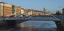 |
|
| Rory O'More Bridge Rory O'More Bridge Rory O'More Bridge is a road bridge spanning the River Liffey in Dublin, Ireland and joining Watling Street to Ellis Street and the north quays.... |
Victoria & Albert Bridge, Queen Victoria Bridge | Road bridge | Watling Street to Ellis Street | 1859 (Previous structures: 1670, 1704) | |
| Frank Sherwin Bridge Frank Sherwin Bridge Frank Sherwin Bridge is a road bridge spanning the River Liffey in Dublin, Ireland. It joins St. John's Road and the south quays from Heuston Station to Wolfe Tone Quay and Parkgate Street on the Northside.... |
Road bridge | St. John's Road West to Wolfe Tone Quay | 1981 | ||
| Seán Heuston Bridge Sean Heuston Bridge Seán Heuston Bridge is a cast iron bridge spanning the River Liffey beside Heuston Station, Dublin. It was previously named King's Bridge and Sarsfield Bridge - and the bridge and adjacent train station are still commonly referred to by older Dubliners as "Kings Bridge" and "Kings Bridge... |
King’s Bridge, Sarsfield Bridge | Light rail and footbridge | Heuston station to Wolfe Tone Ave | 1828 | |
| Liffey Railway Bridge Liffey Bridge (Phoenix Park Tunnel) The Liffey Railway Bridge is a rail bridge spanning the River Liffey near Dublin Heuston railway station in Dublin, Ireland.The bridge is a wrought iron box truss structure, and joins lines from Heuston Station to Connolly Station through the Phoenix Park tunnel.It is used regularly for freight... |
Rail freight bridge | Heuston Station to Phoenix Park Tunnel | |||
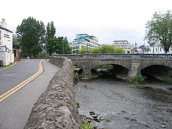
| Island Bridge Island Bridge Island Bridge is a road bridge spanning the River Liffey, in Dublin, Ireland and joining the South Circular Road to Conyngham Road at the Phoenix Park.... |
Sarah Bridge | Road bridge | South Circular Road South Circular Road, Dublin The South Circular Road is a road in Dublin, Ireland, one of the longest in the city. It runs from Kilmainham in the west of the city, through Rialto and Dolphin's Barn to Portobello, near the centre. As it runs mainly through residential areas, it is used by numerous bus routes.-History:Until the... to Conyngham Road |
1794 (Previous structure: 1577) | 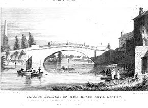 |
| Anna Livia Bridge Anna Livia Bridge The Anna Livia Bridge , formerly Chapelizod Bridge , is a road bridge spanning the River Liffey in Dublin, Ireland and joining the Lucan Road to Chapelizod Road.-History:... |
Chapelizod Bridge | Road bridge | Lucan Road to Chapelizod Road | ||
| Farmleigh Bridge Farmleigh Bridge The Farmleigh Bridge , also known as the Strawberry Beds Bridge, is a privately-owned disused bridge spanning the River Liffey and the Lower Lucan Road in Dublin, Ireland.... |
Disused service bridge | Farmleigh House | |||
| West-Link Bridge West-Link The West-Link is a toll bridge on the M50 motorway to the west of Dublin, Ireland, operated by BetEire Flow Limited for the National Roads Authority.- Structure :... |
Tolled road bridge | M50 motorway M50 motorway (Ireland) The M50 motorway is a motorway in Ireland running in a C-shaped ring around the north-eastern, northern, western and southern sides of the capital city, Dublin. The northern end of the route is located at the entrance to the Dublin Port Tunnel. Anti-clockwise it heads northwest through the tunnel... |
1990 | ||
| Lucan Bridge Lucan Bridge Lucan Bridge is a road bridge spanning the River Liffey in the town of Lucan in Dublin, Ireland. It joins Lucan's Main Street to the Lower Lucan Road, carrying traffic towards Clonsilla and the north.... |
Road bridge | Lower Lucan Road | 1814 (Previous structures: 1200s, 1730s, 1771, 1780s) |
Bridges over the River Liffey
River Liffey
The Liffey is a river in Ireland, which flows through the centre of Dublin. Its major tributaries include the River Dodder, the River Poddle and the River Camac. The river supplies much of Dublin's water, and a range of recreational opportunities.-Name:The river was previously named An Ruirthech,...
outside Greater Dublin, from east to west.
- Sewage treatment works bridge
- Leixlip Bridge [Leixlip Road]
- M4 motorway
- New Bridge [R404]
- Liffey Bridge (Celbridge Bridge) [Dublin Road, CelbridgeCelbridgeCelbridge is a town and townland on the River Liffey in County Kildare, Ireland. It is west of Dublin. As a town within the Dublin Metropolitan Area and the Greater Dublin Area, it is located at the intersection of the R403 and R405 regional roads....
] - Rock Bridge [footbridge at Celbridge Abbey]
- Straffan Bridge
- The Bridge at 16 [19th century wrought iron pedestrian suspension bridge crossing to the 17th teeTeeing groundIn golf, the teeing ground is the area at the beginning of a hole from which the player's first stroke is taken. When referring to the area, the terms "tee", "tee box", and "teeing ground" are often used interchangeably....
in the Kildare Hotel and Golf Club] - Alexandra Bridge [ClaneClaneClane is a town on the River Liffey and in the barony of Clane in County Kildare, Ireland, from Dublin.Its population of 4,968 makes it the eighth largest town in Kildare and the 78th largest in the Republic of Ireland....
] - Millicent Bridge [near SallinsSallinsSallins is a suburban town in County Kildare, Ireland, situated 3.5 km north of the town centre of Naas, from which it is separated by the M7 motorway. Sallins is the anglicised name of Na Solláin which means "The Willows"....
] - Leinster Aqueduct [Grand Canal crossing]
- Railway bridge, MP 19 [Dublin to CorkCork (city)Cork is the second largest city in the Republic of Ireland and the island of Ireland's third most populous city. It is the principal city and administrative centre of County Cork and the largest city in the province of Munster. Cork has a population of 119,418, while the addition of the suburban...
railway crossing] - Caragh Bridge [CaraghCaraghCaragh or Carragh is a village in County Kildare, Ireland. It is located on the R409 regional road between the River Liffey and the Grand Canal approximately 4 km north-west of Naas...
]
Bridges on the Grand Canal
Bridges on the Grand Canal from the River LiffeyRiver Liffey
The Liffey is a river in Ireland, which flows through the centre of Dublin. Its major tributaries include the River Dodder, the River Poddle and the River Camac. The river supplies much of Dublin's water, and a range of recreational opportunities.-Name:The river was previously named An Ruirthech,...
to the south and west. In addition, many of the canal locks
Lock (water transport)
A lock is a device for raising and lowering boats between stretches of water of different levels on river and canal waterways. The distinguishing feature of a lock is a fixed chamber in which the water level can be varied; whereas in a caisson lock, a boat lift, or on a canal inclined plane, it is...
allow for pedestrian crossing.
- MacMahon Bridge [Ringsend Road, Pearse StreetPearse Street, DublinPearse Street is one of the longest streets in Dublin and varies in use along its length. Its western end meets College Street near Townsend Street. Trinity College, Dublin forms its southern side here, with a Garda station to the north. As one proceeds east, Tara Street joins it along with a fire...
] - DART bridge (Victoria Bridge)
- Macquay's Bridge [Grand Canal Street]
- McKenny's Bridge [Northumberland Road, Mount Street Lower]
- Huband Bridge [Mount Street Crescent]
- Macartney Bridge [Baggot StreetBaggot Street, DublinBaggot Street is a street in Dublin, Ireland. It is named after Baggotrath, the manor granted to Robert Bagod in the 13th century. It was called Baggot Street in 1773....
] - Eustace Bridge (Leeson Street Bridge) [Leeson StreetLeeson StreetLeeson Street is a thoroughfare near central Dublin, Ireland.Originally known as Suesey Street, it was renamed in 1728 after the Leesons, a family of local brewers, who branched into property development and subsequently became Earls of Milltown....
] - Charlemont Bridge [Ranelagh Road, Charlemont Street]
- Luas bridge
- Portobello Bridge (La Touche Bridge) [Rathmines Road Lower, Richmond Street South]
- Robert Emmet Bridge (Clanbrassil Bridge) [Harolds Cross Road, Clanbrassil Street Upper]
- Parnell Bridge [Clogher Road]
- Dolphin's Barn Bridge (Camac Bridge) [Dolphin’s Barn, Crumlin Road]
- Herberton Bridge (Herberton Bridge)
- Rialto Bridge over the former main line of the Grand Canal, now over LuasLuasLuas , also promoted in the development stage as the Dublin Light Rail System, is a tram or light rail system serving Dublin, the first such system in the decades since the closure of the last of the Dublin tramways. In 2007, the system carried 28.4 million passengers, a growth of 10% since...
red line [South Circular RoadSouth Circular Road, DublinThe South Circular Road is a road in Dublin, Ireland, one of the longest in the city. It runs from Kilmainham in the west of the city, through Rialto and Dolphin's Barn to Portobello, near the centre. As it runs mainly through residential areas, it is used by numerous bus routes.-History:Until the...
]
- Rialto Bridge over the former main line of the Grand Canal, now over Luas
- Griffith Bridge [Grand Canal View]
- Anne Devlin Bridge [Luas bridge]
- Suir Road Bridge (Harcourt Bridge) [Suir Road]
- Goldenbridge Footbridge
- Blackhorse Bridge (Kelly’s Bridge) [Naas Road, Tyrconnell Road]
- New Bridge [Kylemore Road]
- Ballyfermot Bridge [Killeen Road]
- Park West Avenue
- M50 Motorway
- Clondalkin Bridge [Ninth Lock Road]
- Fonthill Road
- Lucan Road Bridge [R120]
- Gollierstown Bridge
- Hazelhatch Bridge [R405]
- Aylmer's Bridge [Lyons Road]
Bridges on the Royal Canal
Bridges on the Royal CanalRoyal Canal of Ireland
The Royal Canal is a canal originally built for freight and passenger transportation from the River Liffey at Dublin to the River Shannon at Cloondara in County Longford in Ireland. It fell into disrepair, but since has been restored for navigation...
from the River Liffey
River Liffey
The Liffey is a river in Ireland, which flows through the centre of Dublin. Its major tributaries include the River Dodder, the River Poddle and the River Camac. The river supplies much of Dublin's water, and a range of recreational opportunities.-Name:The river was previously named An Ruirthech,...
to the north and west. Many of the bridges include a railroad crossing for railroads adjacent to the canal in much of Dublin. In addition, many of the canal locks
Lock (water transport)
A lock is a device for raising and lowering boats between stretches of water of different levels on river and canal waterways. The distinguishing feature of a lock is a fixed chamber in which the water level can be varied; whereas in a caisson lock, a boat lift, or on a canal inclined plane, it is...
allow for pedestrian crossing and several pedestrian bridges are located adjacent to Iarnród Éireann
Iarnród Éireann
Iarnród Éireann is the national railway system operator of Ireland. Established on 2 February 1987, it is a subsidiary of Córas Iompair Éireann . It operates all internal intercity, commuter and freight railway services in the Republic of Ireland, and, jointly with Northern Ireland Railways, the...
railway stations.
- North Wall Quay Scherzer bascule bridgeBascule bridgeA bascule bridge is a moveable bridge with a counterweight that continuously balances the span, or "leaf," throughout the entire upward swing in providing clearance for boat traffic....
- Spencer Bridge [Mayor Street]
- Sherrif St. Lifting Bridge (inoperable) [Sheriff Street]
- Ossory Road railway bridge (actually three independent bridges) [DART bridge]
- Railway bridge [lifting bridge]
- Newcomen Bridge [North Strand Road]
- Clarke's Bridge [Summerhill Parade, Ballybough Road]
- Clonliffe Bridge (Russell Street Bridge) [Russell Street, Jones's Road]
- Binns Bridge [Drumcondra Road]
- Cross Guns Bridge (Westmoreland Bridge) [Phibsborough Road, Prospect Road]
- Blaquiere Bridge over the former city spur of the Royal Canal [North Circular Road]
- New Cabra Road
- Connaught Street
- Railway bridge at Liffey Junction
- Broom BridgeBroom BridgeBroom Bridge, also known as Brougham Bridge, is a bridge along Broombridge Road which crosses the Royal Canal in Cabra, Dublin, Ireland. Broom Bridge is named after William Brougham, one of the directors of the Royal Canal company...
(Broome Bridge, Brougham Bridge) [Broombridge Road] - Reilly Bridge (Reily's Bridge) [Ratoath Road]
- Railway tunnel
- Railway bridge at Liffey Junction
- Longford Bridge [Ashtown Road]
- Ranelagh Bridge [disused]
- Dunsink Lane Bridge [New River Road]
- Roundabout of Junction 6 of M50 motorwayM50 motorway (Ireland)The M50 motorway is a motorway in Ireland running in a C-shaped ring around the north-eastern, northern, western and southern sides of the capital city, Dublin. The northern end of the route is located at the entrance to the Dublin Port Tunnel. Anti-clockwise it heads northwest through the tunnel...
- two bridges - Royal Canal aqueduct over the M50 motorwayM50 motorway (Ireland)The M50 motorway is a motorway in Ireland running in a C-shaped ring around the north-eastern, northern, western and southern sides of the capital city, Dublin. The northern end of the route is located at the entrance to the Dublin Port Tunnel. Anti-clockwise it heads northwest through the tunnel...
- Talbot Bridge [Old Navan Road]
- Granard Bridge [Castleknock Road]
- Kirkpatrick Bridge [Carpenterstown Road, Coolmine Road]
- Porterstown Bridge
- Kennan Bridge (Neville Bridge) [Porterstown Road]
- Callaghan Bridge (Carhampton Bridge) [R121]
- Pakenham BridgePakenham BridgeThe Pakenham Bridge is a structure unique in North America. It is composed of five masonry arches that span to cross the Mississippi River at the town of Pakenham within Mississippi Mills....
- Collins Bridge
- Cope Bridge [Captain's Hill]
- Royal Canal aqueduct over the Rye Water
- Louisa Bridge
- R449R449 roadThe R449 road is a regional road in County Kildare, Ireland. It is just long and was completed in 2003 as part of the construction of a grade separated interchange to connect both West Leixlip and North Celbridge to the M4 motorway. This junction currently designated 2a.The 2 km section between...
- Deey Bridge
- Pike Bridge
- Mullen BridgeMullen BridgeMullen Bridge is the name of the old bridge crossing the Royal Canal in Maynooth. This uses to be the main road leading South out of the town. In the late 80's/early 90's a new bridge was built alongside it to cater for the increased traffic on the route...
[R406] - Bond Bridge [R408]
- Aqueduct
- Jackson's Bridge
Bridges over the River Dodder
Bridges over the River DodderRiver Dodder
The River Dodder is one of the three main rivers of the Dublin region in Ireland, the others being the Liffey, of which the Dodder is the largest tributary, and the Tolka.-Course and system:...
from the River Liffey
River Liffey
The Liffey is a river in Ireland, which flows through the centre of Dublin. Its major tributaries include the River Dodder, the River Poddle and the River Camac. The river supplies much of Dublin's water, and a range of recreational opportunities.-Name:The river was previously named An Ruirthech,...
to the southwest.
- Ringsend Bridge [Ringsend Road, Bridge Street]
- London Bridge [Bath Avenue, Londonbridge Road], where the Swan River joins
- New Bridge (Herbert's Bridge, Landsdowne Bridge) [Herbert's Road, Landsdowne Road]
- DART bridge
- Ball's Bridge [Pembroke Road, Merrion RoadMerrion RoadMerrion Road in Dublin 4 is a road which runs from the RDS at Anglesea Road in Ballsbridge to Merrion, where it meets the Rock Road, Booterstown. It is home to the RDS, some well known hotels and is part of the Embassy Belt....
] - gives name to the neighbourhoodBallsbridgeBallsbridge is a suburb of Dublin, Ireland, named for the bridge spanning the River Dodder on the south side of the city. The sign on the bridge still proclaims it as "Ball's Bridge" in recognition of the fact that the original bridge in this location was built and owned by a Mr...
. - Bridge at Herbert Park
- Anglesea Bridge (Stillorgan Bridge) [Donnybrook Road, Stillorgan Road]
- Footbridge
- Clonskeagh Bridge [Clonskeagh Road]
- Milltown Bridge [Dundrum Road]
- Footbridge
- "The Nine Arches" Luas bridge
- Classon's Bridge [Churchtown Road]
- Footbridge
- Footbridge
- Waldron's Bridge [Orwell Road]
- Footbridge at Orwell Park
- Pearse Bridge [Rathfarnham Road]
- Footbridge
- Springfield Avenue
- Templeogue Bridge [Old Bridge Road]
- Old Bawn Bridge [Old Bawn Road]
Bridges over the River Tolka
Bridges over the River TolkaRiver Tolka
The River Tolka is one of Dublin's three main rivers, flowing from County Meath to Fingal, within the old County Dublin, and through the north of Dublin city, Ireland. It is one of Dublin's three main rivers, the others being the Liffey and the Dodder...
from the River Liffey
River Liffey
The Liffey is a river in Ireland, which flows through the centre of Dublin. Its major tributaries include the River Dodder, the River Poddle and the River Camac. The river supplies much of Dublin's water, and a range of recreational opportunities.-Name:The river was previously named An Ruirthech,...
to the northwest.
- Bridge to East Point Business ParkEast Point Business ParkEast Point Office Park in the docklands area of Dublin, Ireland is one of the country's largest business parks, being the place of employment for thousands of people. It is situated in the East Wall area....
- John McCormack Bridge
- Fairview Park Footbridge
- Annesley BridgeAnnesley BridgeAnnesley Bridge crosses the River Tolka in Fairview. The bridge was built in 1797. It is named after Richard Annesley and was demolished and rebuilt in 1926....
- Luke Kelly Bridge (Ballybough Bridge)
- Distillery Road Bridge [foot bridge]
- Drumcondra Bridge
- Woodville Road Footbridge
- Footbridge
- Dean Swift Bridge (St. Mobhi Bridge) [St. Mobhi Road]
- Glasnevin Bridge
- Footbridge in Botanic Gardens
- Tolka Bridge (Finglas Bridge)
- Finglaswood Bridge
- Cardiff's Bridge
- Ashtown Bridge
- M50 Motorway
Other bridges
- Bow Bridge over the River CamacRiver CamacThe River Camac is one of the larger rivers in Dublin, Ireland, and was one of four tributaries of the Liffey critical to early development of the city.-Course:...
(Cammock) connecting Irwin Street and Bow Lane West - Dargan BridgeDargan Bridge, DublinWilliam Dargan Bridge, opened in 2004, is a cable-stayed bridge in Dundrum, Dublin in Ireland. It carries the LUAS light rail line across a busy road junction...
, a LUAS Green Line bridge over the R112 and R117 regional roads and the Slang River - Golden Bridge over the River Camac connecting Kilmainham Lane with Old Kilmainham
- Knocksedan Bridge over the River WardRiver WardRiver Ward is city ward located in Ottawa, Ontario. Located in the central west/south central portion of the city, the ward includes the communities of Carlington, Skyline, Parkwood Hills, Fisher Heights, Mooney's Bay, Riverside Park and Hunt Club/Uplands which are located on both sides of the...
west of SwordsSwords, DublinSwords is the county town of Fingal in Ireland. It is about 13 km north of Dublin city centre and is part of its commuter belt.- History :...
on the Naul Road - Malahide Estuary Bridge of the M1 over the Malahide Estuary near SwordsSwords, DublinSwords is the county town of Fingal in Ireland. It is about 13 km north of Dublin city centre and is part of its commuter belt.- History :...
- Mayne Bridge over the River Mayne north of BaldoyleBaldoyleBaldoyle is a small coastal area on the northside of Dublin, Ireland. It is in the part of the historic County Dublin now administered as Fingal.-Location and Access:...
on the Coast Road - Portmarnock Bridge over the River Sluice west of PortmarnockPortmarnockPortmarnock is a small suburban village to the north of Dublin, Ireland. It is in the administrative county of Fingal.-Location:Portmarnock lies on the coast and, owing to its proximity to Dublin city, is a form of dormitory village north-northeast of the city centre...
on the Strand Road - Scotchstone Bridge over the River Ward in Swords
- Wellfield Bridge over the River Mayne north of DonaghmedeDonaghmedeDonaghmede is a residential suburb of Dublin, in the province of Leinster, Ireland.-Location:Donaghmede is situated approximately to the north east of the Dublin city centre, and is in the constituency of Dublin North East...
on The Hole in the Wall Road - Wooden Bridge connecting Clontarf Road with North Bull Island
- O'Connell Bridge, St Stephen's Green, crossing the lake in the park.
Tunnels
- Dublin Port TunnelDublin Port TunnelThe Dublin Port Tunnel is a road traffic tunnel in Dublin, Ireland, that forms part of the M50 motorway....
(Tollán Calafoirt Bhaile Átha Cliath) - Phoenix Park TunnelLiffey Bridge (Phoenix Park Tunnel)The Liffey Railway Bridge is a rail bridge spanning the River Liffey near Dublin Heuston railway station in Dublin, Ireland.The bridge is a wrought iron box truss structure, and joins lines from Heuston Station to Connolly Station through the Phoenix Park tunnel.It is used regularly for freight...
[rail freight tunnel] - Railway tunnel under the Royal Canal [rail freight tunnel]
- Grand Canal Sewer Tunnel
- Liffey Service TunnelLiffey Service TunnelThe Liffey Service Tunnel is a service tunnel for various pipelines in Dublin, Ireland, owned by .The tunnel was designed by ' and constructed by a Joint Venture of the German Contractor ', Stuttgart and the Irish Contractor ', Wexford...
See also
- List of rivers in County Dublin
- Streets and squares in DublinStreets and squares in DublinThis article deals with the streets and squares in Dublin and the Greater Dublin Area of Ireland.- Street naming :Most streets in Dublin carry names given during the period of English colonial rule. Some streets were renamed during the late colonial or Free State periods for Irish persons.Street...
- List of streets and squares in Dublin
- Transport in Dublin
- List of Dublin Gates