
Levél
Encyclopedia
Levél is a village in Győr-Moson-Sopron
county, Hungary
.
, close to the M1
motorway between Mosonmagyaróvár
and Hegyeshalom
. It is on the international bicycle road to Hegyeshalom and Rajka
.
text of 1410. The Hungarian name first appears in a tax registration in 1532. The Turkish
local governor depopulated the village in 1529. In 1570 Maximilian II
deported the Württemberg
Saxons to the area. The French
occupation of 1809 resulted in economic hardship for the population. The village gained access to electricity in 1926. In the Second World War the village's agricultural produce and livestock was requisitioned by the Wehrmacht
, leading to food shortages. Most of German population was deported after the war. During the Communist era, the area saw economic growth brought on by state investment.
. 49% of the population work in industry
, 6.5% in agriculture
and 15% in commerce. Much of the population works in Mosonmagyaróvár.
conduit system was constructed in 1997. 98% of the population have telephone lines, and cable television is common.
Gyor-Moson-Sopron
Győr-Moson-Sopron is the name of an administrative county in north-western Hungary, on the border with Slovakia and Austria. It shares borders with the Hungarian counties Komárom-Esztergom, Veszprém and Vas. The capital of Győr-Moson-Sopron county is Győr...
county, Hungary
Hungary
Hungary , officially the Republic of Hungary , is a landlocked country in Central Europe. It is situated in the Carpathian Basin and is bordered by Slovakia to the north, Ukraine and Romania to the east, Serbia and Croatia to the south, Slovenia to the southwest and Austria to the west. The...
.
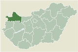
Geography
Levél is in the north-west of HungaryHungary
Hungary , officially the Republic of Hungary , is a landlocked country in Central Europe. It is situated in the Carpathian Basin and is bordered by Slovakia to the north, Ukraine and Romania to the east, Serbia and Croatia to the south, Slovenia to the southwest and Austria to the west. The...
, close to the M1
M1 motorway (Hungary)
The M1 motorway is a long highway in northwestern Hungary, connecting Budapest to Győr and Vienna. The first section of the motorway opened in the 1970s, reaching the Austrian border at Hegyeshalom in 1996. It follows the route of the old Route 1 one-lane highway.- Junctions, exits and rest areas...
motorway between Mosonmagyaróvár
Mosonmagyaróvár
Mosonmagyaróvár is a city in Győr-Moson-Sopron county in northwestern Hungary. It lies close to both the Austrian and Slovakian borders and has a population of 30,200 ....
and Hegyeshalom
Hegyeshalom
Hegyeshalom is a village of approximately 3600 inhabitants in the Győr-Moson-Sopron county of Hungary, on the border with Austria and less than 15 km from the border with Slovakia.- History :...
. It is on the international bicycle road to Hegyeshalom and Rajka
Rajka
Rajka is a village in Győr-Moson-Sopron county, Hungary.The European motorway E65/E75, as well as national roads, cross into Slovakia near Rajka. The Slovak border crossings are known as Rusovce and Čunovo...
.
History
The village was first mentioned as Kalthostan in a GermanGermany
Germany , officially the Federal Republic of Germany , is a federal parliamentary republic in Europe. The country consists of 16 states while the capital and largest city is Berlin. Germany covers an area of 357,021 km2 and has a largely temperate seasonal climate...
text of 1410. The Hungarian name first appears in a tax registration in 1532. The Turkish
Ottoman Empire
The Ottoman EmpireIt was usually referred to as the "Ottoman Empire", the "Turkish Empire", the "Ottoman Caliphate" or more commonly "Turkey" by its contemporaries...
local governor depopulated the village in 1529. In 1570 Maximilian II
Maximilian II, Holy Roman Emperor
Maximilian II was king of Bohemia and king of the Romans from 1562, king of Hungary and Croatia from 1563, emperor of the Holy Roman Empire of the German Nation from 1564 until his death...
deported the Württemberg
Württemberg
Württemberg , formerly known as Wirtemberg or Wurtemberg, is an area and a former state in southwestern Germany, including parts of the regions Swabia and Franconia....
Saxons to the area. The French
France
The French Republic , The French Republic , The French Republic , (commonly known as France , is a unitary semi-presidential republic in Western Europe with several overseas territories and islands located on other continents and in the Indian, Pacific, and Atlantic oceans. Metropolitan France...
occupation of 1809 resulted in economic hardship for the population. The village gained access to electricity in 1926. In the Second World War the village's agricultural produce and livestock was requisitioned by the Wehrmacht
Wehrmacht
The Wehrmacht – from , to defend and , the might/power) were the unified armed forces of Nazi Germany from 1935 to 1945. It consisted of the Heer , the Kriegsmarine and the Luftwaffe .-Origin and use of the term:...
, leading to food shortages. Most of German population was deported after the war. During the Communist era, the area saw economic growth brought on by state investment.
Demographics
The population of the area is gradually increasing. Statistically, 50-60% of the population require income support. Only 6% of the population have completed higher educationHigher education
Higher, post-secondary, tertiary, or third level education refers to the stage of learning that occurs at universities, academies, colleges, seminaries, and institutes of technology...
. 49% of the population work in industry
Industry
Industry refers to the production of an economic good or service within an economy.-Industrial sectors:There are four key industrial economic sectors: the primary sector, largely raw material extraction industries such as mining and farming; the secondary sector, involving refining, construction,...
, 6.5% in agriculture
Agriculture
Agriculture is the cultivation of animals, plants, fungi and other life forms for food, fiber, and other products used to sustain life. Agriculture was the key implement in the rise of sedentary human civilization, whereby farming of domesticated species created food surpluses that nurtured the...
and 15% in commerce. Much of the population works in Mosonmagyaróvár.
Infrastructure
The infrastructure of the village is seen as generally good. A waterWater
Water is a chemical substance with the chemical formula H2O. A water molecule contains one oxygen and two hydrogen atoms connected by covalent bonds. Water is a liquid at ambient conditions, but it often co-exists on Earth with its solid state, ice, and gaseous state . Water also exists in a...
conduit system was constructed in 1997. 98% of the population have telephone lines, and cable television is common.
External links
- Street map
- http://www.level.hu/index.php?modul=menupontok&kod=95