
Laurel, California
Encyclopedia
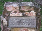
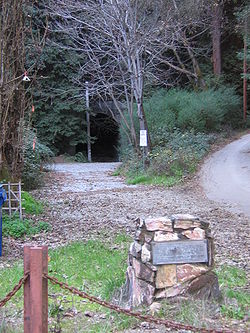
Laurel is a ghost town
in Santa Cruz County
, California
, United States
, in the Santa Cruz Mountains
. The exact location of Laurel is latitude 370700N, longitude 1215755W; the decimal degrees are latitude 37.11667, longitude -121.96528. It is in a valley at an elevation of 900 feet (274.3 m) above sea level.
 The railroad was completed in 1880 from Los Gatos, along the Los Gatos Creek, to Wrights Station
(sometimes designated "Wright's Station" or simply "Wrights"), about a mile east of Patchen
. From Wrights Station it went through a 2 miles (3 km) tunnel to Laurel, then through other tunnels to Scotts Valley and Santa Cruz
. The railroad was later purchased by the Southern Pacific.
The area was seriously affected by the April 18, 1906 earthquake
, largely because the San Andreas Fault
passes through the mountains. There were numerous offsets and fissures, resulting in damage to the rails, bridges, and tunnels. Homes and businesses were damaged or destroyed as well. The railroad recovered from the disaster and operated until heavy rains in February 1940 caused major landslides; the Southern Pacific decided not to repair the damage. Completion of State Route 17, west of Laurel, that same year also contributed to the demise of the railroad and several small communities, including Laurel, that were located along the railroad right-of-way. Since then, some homes have been built around the site of Laurel, but the village itself no longer exists. Laurel Drive passes through the village's site.
Ghost town
A ghost town is an abandoned town or city. A town often becomes a ghost town because the economic activity that supported it has failed, or due to natural or human-caused disasters such as floods, government actions, uncontrolled lawlessness, war, or nuclear disasters...
in Santa Cruz County
Santa Cruz County, California
Santa Cruz County is a county located on the Pacific coast of the U.S. state of California, on the California Central Coast. The county forms the northern coast of the Monterey Bay. . As of the 2010 U.S. Census, its population was 262,382. The county seat is Santa Cruz...
, California
California
California is a state located on the West Coast of the United States. It is by far the most populous U.S. state, and the third-largest by land area...
, United States
United States
The United States of America is a federal constitutional republic comprising fifty states and a federal district...
, in the Santa Cruz Mountains
Santa Cruz Mountains
The Santa Cruz Mountains, part of the Pacific Coast Ranges, are a mountain range in central California, United States. They form a ridge along the San Francisco Peninsula, south of San Francisco, separating the Pacific Ocean from San Francisco Bay and the Santa Clara Valley, and continuing south,...
. The exact location of Laurel is latitude 370700N, longitude 1215755W; the decimal degrees are latitude 37.11667, longitude -121.96528. It is in a valley at an elevation of 900 feet (274.3 m) above sea level.
History
A toll road was built from Los Gatos to Santa Cruz, passing through the eventual site of Laurel, and was utilized by stagecoaches. Then, a narrow gauge railroad was constructed over the mountains, to provide transportation for lumber and the numerous crops grown in the area. During the construction of the main railroad tunnel, a strong flow of natural gas was encountered, and an explosion followed, which resulted in the death of thirty-two Chinese workers. The main leak was subsequently stopped, but gas continued to escape in small quantities. The extent of the supply was unknown.Wrights, California
Wrights, California is a locale in Santa Clara County, California in the Santa Cruz Mountains, at , near Summit Road, east of State Route 17. It is located on the north bank of Los Gatos Creek....
(sometimes designated "Wright's Station" or simply "Wrights"), about a mile east of Patchen
Patchen, California
Patchen, California, is a ghost town on the Old Santa Cruz Highway, east of State Route 17 in the Santa Cruz Mountains in Santa Clara County.-History:...
. From Wrights Station it went through a 2 miles (3 km) tunnel to Laurel, then through other tunnels to Scotts Valley and Santa Cruz
Santa Cruz, California
Santa Cruz is the county seat and largest city of Santa Cruz County, California in the US. As of the 2010 U.S. Census, Santa Cruz had a total population of 59,946...
. The railroad was later purchased by the Southern Pacific.
The area was seriously affected by the April 18, 1906 earthquake
1906 San Francisco earthquake
The San Francisco earthquake of 1906 was a major earthquake that struck San Francisco, California, and the coast of Northern California at 5:12 a.m. on Wednesday, April 18, 1906. The most widely accepted estimate for the magnitude of the earthquake is a moment magnitude of 7.9; however, other...
, largely because the San Andreas Fault
San Andreas Fault
The San Andreas Fault is a continental strike-slip fault that runs a length of roughly through California in the United States. The fault's motion is right-lateral strike-slip...
passes through the mountains. There were numerous offsets and fissures, resulting in damage to the rails, bridges, and tunnels. Homes and businesses were damaged or destroyed as well. The railroad recovered from the disaster and operated until heavy rains in February 1940 caused major landslides; the Southern Pacific decided not to repair the damage. Completion of State Route 17, west of Laurel, that same year also contributed to the demise of the railroad and several small communities, including Laurel, that were located along the railroad right-of-way. Since then, some homes have been built around the site of Laurel, but the village itself no longer exists. Laurel Drive passes through the village's site.