

Lassance
Encyclopedia
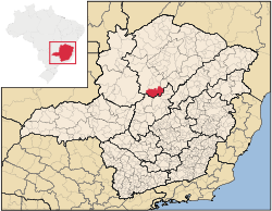
Minas Gerais
Minas Gerais is one of the 26 states of Brazil, of which it is the second most populous, the third richest, and the fourth largest in area. Minas Gerais is the Brazilian state with the largest number of Presidents of Brazil, the current one, Dilma Rousseff, being one of them. The capital is the...
. In 2007 the population was 6,458 in a total area of 3,213 km². It became a municipality in 1953.
Location and Distances
Lassance is located on federal highway BR-496 at an elevation of 504 meters. It is south of the nearest population center, PiraporaPirapora
Pirapora is a municipality in northcentral Minas Gerais in Brazil. Its population in 2007 was 51,636 in a total area of 577 km². The name Pirapora comes from the Tupi words for "fish" + "jump", referring to the piracema season when a mass migration of fishes ascends the São Francisco River...
and north of Corinto
Corinto
Corinto may refer to any of the following:Brazil*Corinto, Minas GeraisColombia*Corinto, CaucaEl Salvador*Corinto, MorazánNicaragua*Corinto, Nicaragua...
. The municipality is crossed by the Rio das Velhas, a tributary of the São Francisco River
São Francisco River
The São Francisco is a river in Brazil. With a length of , it is the longest river that runs entirely in Brazilian territory, and the fourth longest in South America and overall in Brazil...
. Neighboring municipalties are: Buritizeiro
Buritizeiro
Buritizeiro is a municipality in the north of the Brazilian state of Minas Gerais. Its population in 2007 was 26,133 inhabitants in a total area of 7,226 km². It is a major producer of cattle and grains.-Location:...
, Várzea da Palma
Várzea da Palma
Várzea da Palma is a municipality in north-central Minas Gerais in Brazil. Its population in 2007 was 54,448 in a total area of 2,195 km²....
, Buenópolis
Buenópolis
Buenópolis is a Brazilian municipality located in the northeast of the state of Minas Gerais. Its population as of 2007 was 9,522 living in a total area of 1,610 km². The city belongs to the statistical mesoregion of Central Mineira and to the statistical microregion of Curvelo. It became a...
, and Confria. Lassance is part of the statistical microregion of Pirapora. It is 263 km. from the state capital of Belo Horizonte
Belo Horizonte
Belo Horizonte is the capital of and largest city in the state of Minas Gerais, located in the southeastern region of Brazil. It is the third largest metropolitan area in the country...
.
Economic activities
The most important economic activities are cattle raising (35,000 head in 2006), mining, industry, and agriculture. The GDP in 2005 was R$ 36,064,000. The most important agricultural crops are bananas, papaya, mangoes, rice, sugarcane, manioc, beans and corn. There were 247 automobiles. In the rural area there were 450 producers. The total area of agricultural land was 88,000 hectares in 2006, of which 4,500 ha. were planted in crops. As of 2006 there were 124 tractors. In the urban area there were no banking agencies in 2006.Health and education
This municipality is isolated from major population centers and suffers from drought and poor soils.- Municipal Human Development IndexHuman Development IndexThe Human Development Index is a composite statistic used to rank countries by level of "human development" and separate "very high human development", "high human development", "medium human development", and "low human development" countries...
: 0.681 (2000) - State ranking: 630 out of 853 municipalities as of 2000
- National ranking: 3,283 out of 5,138 municipalities as of 2000
The highest ranking municipality in Minas Gerais in 2000 was Poços de Caldas
Poços de Caldas
Poços de Caldas is a city and municipality in south-western Minas Gerais state, Brazil, in the microregion of the same name. Its estimated population in 2009 was 151,449 inhabitants...
with 0.841, while the lowest was Setubinha
Setubinha
Setubinha is a municipality in the northeast of the Brazilian state of Minas Gerais. As of 2007 the population was 10,834 in a total area of 536 km². The elevation is 729 metres. It is part of the IBGE statistical microregion of Teófilo Otoni...
with 0.568. Nationally the highest was São Caetano do Sul
São Caetano do Sul
São Caetano do Sul is a city in São Paulo state in Brazil, located in the Greater São Paulo Metropolitan Area. It is the city with the highest per capita income in Brazil and it also has the highest Human Development Index .-Geography:São Caetano do Sul is located on a plateau that is part of the...
in São Paulo with 0.919, while the lowest was Setubinha.
- Degree of urbanization: 49.97% (2000) The rate for Minas Gerais was 82%
- Infant mortality rate: 28.57 (2000) The rate for Minas Gerais was 17.40; the rate for Brazil was 18.91.
- Illiteracy rate: 21.02% (15 years old or older)(Data from 2000) The rate for Minas Gerais was 11.96; the rate for Brazil was 13.63
- Urban area covered by sewage system: 0.40%--the rate for Minas Gerais was 81.39%
- Health centers and hospitals: 04 health centers. There were no hospitals. The nearest large hospital was in Pirapora.