
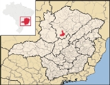
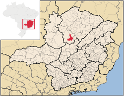
Várzea da Palma
Encyclopedia
| Várzea da Palma | |
|---|---|
| State | Minas Gerais Minas Gerais Minas Gerais is one of the 26 states of Brazil, of which it is the second most populous, the third richest, and the fourth largest in area. Minas Gerais is the Brazilian state with the largest number of Presidents of Brazil, the current one, Dilma Rousseff, being one of them. The capital is the... |
| Geographical coordinates: | 17°35′52"S 44°43′51"W |
| Area: | 2,195 km |
| Population: | 65,448 (IBGE 2007) |
| Elevation: | 519 m above sea level |
| Postal code (CEP): | 39260-000 |
| Became a city: | 1953 |
| Statistical Microregion: | Pirapora |
| Distance to Belo Horizonte Belo Horizonte Belo Horizonte is the capital of and largest city in the state of Minas Gerais, located in the southeastern region of Brazil. It is the third largest metropolitan area in the country... : |
351 km. |
| Website: | not available |
Minas Gerais
Minas Gerais is one of the 26 states of Brazil, of which it is the second most populous, the third richest, and the fourth largest in area. Minas Gerais is the Brazilian state with the largest number of Presidents of Brazil, the current one, Dilma Rousseff, being one of them. The capital is the...
in Brazil
Brazil
Brazil , officially the Federative Republic of Brazil , is the largest country in South America. It is the world's fifth largest country, both by geographical area and by population with over 192 million people...
. Its population in 2007 was 54,448 in a total area of 2,195 km².
Várzea da Palma is located east of the São Francisco River
São Francisco River
The São Francisco is a river in Brazil. With a length of , it is the longest river that runs entirely in Brazilian territory, and the fourth longest in South America and overall in Brazil...
and is on the Rio das Velhas, a tributary of the São Francisco. It is 37 km. southeast of Pirapora
Pirapora
Pirapora is a municipality in northcentral Minas Gerais in Brazil. Its population in 2007 was 51,636 in a total area of 577 km². The name Pirapora comes from the Tupi words for "fish" + "jump", referring to the piracema season when a mass migration of fishes ascends the São Francisco River...
, the most important city of the region. A railroad line, now only freight, runs through the city. Neighboring municipalities are Pirapora
Pirapora
Pirapora is a municipality in northcentral Minas Gerais in Brazil. Its population in 2007 was 51,636 in a total area of 577 km². The name Pirapora comes from the Tupi words for "fish" + "jump", referring to the piracema season when a mass migration of fishes ascends the São Francisco River...
and Lassance
Lassance
Lassance is a Brazilian municipality located in the north of the state of Minas Gerais. In 2007 the population was 6,458 in a total area of 3,213 km². It became a municipality in 1953.-Location and Distances:...
.
The former village of Palma Velha was a cluster of huts that served as a campsite for muleteers coming from different regions, on their way to Curvelo
Curvelo
Curvelo is a city and municipality in the state of Minas Gerais, Brazil. It is located in the geodesic centre of Minas Gerais, 170 km. north of the capital, Belo Horizonte, and connected to the capital by highways MG 135 and BR 040. Its estimated population is 74.409 inhabitants and the...
. With the building of the railroad Estrada de Ferro Central do Brasil, in 1910, the village changed its name to Várzea da Palma. Around the central station settlers began to make their houses attracted by commerce and the movement of the new railroad line.
Custódio Fernandes Sampaio, considered the founder of the city, was responsible for donating part of his lands for the building of the first church.
In 1948, Várzea da Palma was elevated to the category of district and in 1953 it became a municipality.
The main economic activities are cattle raising for meat production, metal industry, and farming. There is an industry manufacturing iron alloys. The GDP for 2005 was R$ 447,177,000. In 2005 around 2,500 people were working in 120 transformation industries. There were 03 banking agencies.
In the rural area there were 596 establishments in 2006. The total area of agricultural land was 128,000 hectares, of which 16,000 ha. were planted in crops, 79,000 ha. were natural pasture, and 30,000 were woodland or forest. There were around 2,000 people in agriculture. 110 of the farms had tractors, a ratio of one tractor for every 5 farms. The size of the cattle herd was 85,000 head. The main permanent crops were bananas, coffee, coconut, citrus and tropical fruits, hearts of palm, and table grapes. The main perennial crops were rice, sugarcane, beans, manioc, corn (2,400 ha.), soybeans, and tomatoes.
In the health sector there were 22 health establishments (2005), of which 16 were public and 6 were private. There was 01 private hospital with 48 beds. The score on the Municipal Human Development Index
Human Development Index
The Human Development Index is a composite statistic used to rank countries by level of "human development" and separate "very high human development", "high human development", "medium human development", and "low human development" countries...
was 0.726. Várzea da Palma was ranked 438 out of 853 municipalities in the state, with Poços de Caldas
Poços de Caldas
Poços de Caldas is a city and municipality in south-western Minas Gerais state, Brazil, in the microregion of the same name. Its estimated population in 2009 was 151,449 inhabitants...
in first place with 0.841 and Setubinha
Setubinha
Setubinha is a municipality in the northeast of the Brazilian state of Minas Gerais. As of 2007 the population was 10,834 in a total area of 536 km². The elevation is 729 metres. It is part of the IBGE statistical microregion of Teófilo Otoni...
in last place with 0.568. Nationally it was ranked 2,500 out of 5,138 municipalities in 2000.