
Lake Tinaroo
Encyclopedia
Lake Tinaroo, also known as Tinaroo Dam, is a man-made reservoir on the Atherton Tableland
in Far North
Queensland
, Australia
. It was constructed between 1953 and 1958 on the Barron River close to Lake Barrine
and Lake Eacham (Yidyam)
.
went underwater, and all of the residents relocated to Yungaburra and surrounding towns (see Unexpected flooding below).
 The area around Kulara was among the last to flood when the dam filled. Earlier the area of Danbulla, located on Robson's Creek - which also feeds into the lake, went underwater. Most of these residents relocated to the tablelands area as their farms were resumed.
was the first European explorer and prospector to visit the tablelands in 1875. The area is now called "The Atherton Tableland
" after John Atherton
who settled at Emerald End Station, at the junction of Emerald Creek and the Barron River. It is reported through popular legend that upon discovering alluvial tin
at the headwaters of the creek, Mr Atherton shouted "Tin, Harroo!!" to his prospecting mate - hence the name.
415 square kilometres of farmland are irrigated by the lake when it supplies its 205,000 megalitres of water each year. Farmers access this water from the extensive network of 176 kilometres of channels using either a gravity fed system or pumps. Areas not serviced by the channels can draw water from streams that have their water replenished by the Barron River, which, in turn, is fed by the lake.
became operational in May, 2004 and generates 1.6 megawatts , thereby stopping 8450 tons of carbon dioxide
from entering the atmosphere each year. The dam is used to regulate the waterflow for use at the Barron Gorge Power Station.
, Walkamin
, Mareeba
, Kuranda
, Mutchilba
, Dimbulah
and Yungaburra
are supplied from Tinaroo Dam through the Barron River.
According to the SunWater publicity material - there will be no capacity upgrade. The upgrade consists of reinforcing the dam to increase safety, in its current capacity.
 With over 200 kilometres of shoreline, Lake Tinaroo offers many bays with smooth water that are protected from the wind. To this end, the lake is often used for sailing
, water skiing
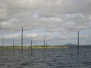
, houseboating and swimming. During the drought of the last few years, some of the trees that were flooded during the dam's creation have become a hazard to boats because of the receding waters. The park services that maintain the recreational areas of the dam have had to trim the dead trees that have appeared. Thankfully the dam's waters are now higher, so this is no longer a problem.
There are still large areas of flooded vegetation, including trees and other man-made objects such as telephone poles, which stand around in the waters of the Lake. The degree of exposure varying with the water level. As far as I know the policy of the people that control the Lake is that standing timber should remain as fish habitat. There have been a few instances of unauthorised clearing of dead trees in some areas of the Lake.
, rainforest
, pine tree plantations and Australian "bush". Hiking
paths wind in and out of the mountains surrounding the lake and range from a pleasant walk from the parking lot to the water-front, to week long treks around the lake and its mountains.
can grow to an enormous size in the lake because they have no natural predators (except for the occasional speedboat). Each year, the lake is stocked with fresh baby "Barra" from the Walkamin
Research Station because the fish are unable to breed due to the lack of access to salt water
. Also on the menu at Lake Tinaroo are eel-tailed catfish
, sooty grunter, sleepy cod
, mouth almighty, archer fish, spangled perch, long tom
and many species of crayfish
, including the red-claw
and yabby
.
A Stocked Impoundment Permit is required to fish in the dam.
Tilapia
were illegally introduced into Lake Tinaroo and are now well established. They have been declared a noxious pest species and must be destroyed and buried if caught. It is illegal to possess, rear, sell or buy tilapia. It is also an offence to release tilapia into Queensland waterways or to use them as bait, live or dead. Heavy penalties apply if caught.
Source
Atherton Tableland
The Atherton Tableland is a fertile plateau which is part of the Great Dividing Range in Queensland, Australia. It is located west to south-south-west inland from Cairns, well into the tropics, but its elevated position provides a climate suitable for dairy farming. It has an area of around...
in Far North
Far North Queensland
Far North Queensland, or FNQ, is the northernmost part of the Australian state of Queensland. The region, which contains a large section of the Tropical North Queensland area, stretches from the city of Cairns north to the Torres Strait...
Queensland
Queensland
Queensland is a state of Australia, occupying the north-eastern section of the mainland continent. It is bordered by the Northern Territory, South Australia and New South Wales to the west, south-west and south respectively. To the east, Queensland is bordered by the Coral Sea and Pacific Ocean...
, Australia
Australia
Australia , officially the Commonwealth of Australia, is a country in the Southern Hemisphere comprising the mainland of the Australian continent, the island of Tasmania, and numerous smaller islands in the Indian and Pacific Oceans. It is the world's sixth-largest country by total area...
. It was constructed between 1953 and 1958 on the Barron River close to Lake Barrine
Lake Barrine
Lake Barrine is a freshwater lake situated on the eastern parts of Atherton Tableland in Far North Queensland, Australia, close to Lake Eacham. The lake and surrounds are protected within the Crater Lakes National Park and are accessible via the Gillies Highway.Lake Barrine was formed over...
and Lake Eacham (Yidyam)
Lake Eacham
Lake Eacham: is a popular lake of volcanic origin on the Atherton Tableland of Queensland, Australia, within the World Heritage listed Wet Tropics of Queensland.-Origins:...
.
History
In 1952, The Tinaroo Dam and Mareeba-Dimbulah Irrigation Scheme was approved by the state government. Construction on the dam was started in 1953 and completed in 1958, at a cost of $12,666,000. The dam wall is 45.1 metres high and traps enough water from the Barron River to create a lake 3/4 the size of Sydney Harbour with a capacity of 407,000 megalitres. When the dam was filled in 1959, the old township of Kulara near YungaburraYungaburra, Queensland
Yungaburra is a town located on the Atherton Tableland in Far North Queensland, Australia, not far from Cairns. At the 2006 census, Yungaburra had a population of 932.-History:...
went underwater, and all of the residents relocated to Yungaburra and surrounding towns (see Unexpected flooding below).
The name "Tinaroo"
James MulliganJames Venture Mulligan
James Venture Mulligan was a bushman and prospector. He was born in Drumgooland, County Down, Ireland and emigrated to Australia in 1859...
was the first European explorer and prospector to visit the tablelands in 1875. The area is now called "The Atherton Tableland
Atherton Tableland
The Atherton Tableland is a fertile plateau which is part of the Great Dividing Range in Queensland, Australia. It is located west to south-south-west inland from Cairns, well into the tropics, but its elevated position provides a climate suitable for dairy farming. It has an area of around...
" after John Atherton
John Atherton (pioneer)
John Atherton was an explorer of the Far North Queensland area of Queensland, Australia.-Childhood and early life:John Atherton was born in Lancashire, England and was the second son of nine children...
who settled at Emerald End Station, at the junction of Emerald Creek and the Barron River. It is reported through popular legend that upon discovering alluvial tin
Tin
Tin is a chemical element with the symbol Sn and atomic number 50. It is a main group metal in group 14 of the periodic table. Tin shows chemical similarity to both neighboring group 14 elements, germanium and lead and has two possible oxidation states, +2 and the slightly more stable +4...
at the headwaters of the creek, Mr Atherton shouted "Tin, Harroo!!" to his prospecting mate - hence the name.
Unexpected flooding
After the dam was completed in 1958, there was expected to be another few months before the annual rains to do some final earthworks at the base of the dam, and to clear out the final settlements in the area. Unfortunately the rains began earlier than expected and to this day there are still some pieces of large construction equipment under water at the base of the dam wall, because they were not able to be removed in time.Creating a Dam
The dam filled in the first instance according to a schedule. Once construction on the last monolith had raised it above the outlet pipes the dam wall was sealed off using a planned procedure where the prepared tunnel under monolith 19 was closed. This allowed the dam to start filling up to the river outlet level.The dam filled progressively over the next few years and did not actually overflow until 1963, far later than originally expected.Irrigation
Covering almost 1200 square kilometres, the Mareeba-Dimbulah Irrigation Area is spread across the valleys of the Barron, Walsh and Mitchell Rivers.415 square kilometres of farmland are irrigated by the lake when it supplies its 205,000 megalitres of water each year. Farmers access this water from the extensive network of 176 kilometres of channels using either a gravity fed system or pumps. Areas not serviced by the channels can draw water from streams that have their water replenished by the Barron River, which, in turn, is fed by the lake.
Power generation
The Tinaroo Hydro Power StationTinaroo Hydro Power Station
The Tinaroo Hydro Power Station in Tinaroo, Queensland is an electricity power station located at the spillway of Lake Tinaroo. It has been designed to take advantage of water being released for irrigation, and water released when the dam is full....
became operational in May, 2004 and generates 1.6 megawatts , thereby stopping 8450 tons of carbon dioxide
Carbon dioxide
Carbon dioxide is a naturally occurring chemical compound composed of two oxygen atoms covalently bonded to a single carbon atom...
from entering the atmosphere each year. The dam is used to regulate the waterflow for use at the Barron Gorge Power Station.
Urban water supply
The townships of TinarooTinaroo, Queensland
Tinaroo is a town in Far North Queensland, Australia. It is located on Lake Tinaroo, man-made reservoir of the same name. At the 2006 census, Tinaroo had a population of 266.-External links:*...
, Walkamin
Walkamin, Queensland
Walkamin is a town on the Atherton Tableland in Far North Queensland, Australia. It is located between Mareeba and Tolga. At the 2006 census, Walkamin and the surrounding area had a population of 630....
, Mareeba
Mareeba, Queensland
Mareeba is a town on the Atherton Tableland in Far North Queensland, Australia. The town is above sea level on the confluence of the Barron River, Granite Creek and Emerald Creek. The town's name is derived from an Aboriginal word meaning meeting of the waters...
, Kuranda
Kuranda, Queensland
Kuranda is a town on the Atherton Tableland in Far North Queensland, Australia, it is 25 kilometres from Cairns, via the Kuranda Range road. It is surrounded by rainforest. At the 2006 census, Kuranda had a population of 1,611.-History:...
, Mutchilba
Mutchilba, Queensland
Mutchilba is a small farming town on the Atherton Tableland in Far North Queensland, Australia. It is located on the Mareeba-Dimbulah Road 34 kilometres west of Mareeba. It is known for its large production of mangoes.-Mango Mardi Gras:...
, Dimbulah
Dimbulah, Queensland
Dimbulah is a town located in Far North Queensland, Australia, 114 kilometres from Cairns by road, on the Atherton Tableland. The town was established in 1876 to service the Tyrconnell Gold Mine, one of the richest mines on the Hodgkinson Gold Fields...
and Yungaburra
Yungaburra, Queensland
Yungaburra is a town located on the Atherton Tableland in Far North Queensland, Australia, not far from Cairns. At the 2006 census, Yungaburra had a population of 932.-History:...
are supplied from Tinaroo Dam through the Barron River.
Maintenance
SunWater has scheduled a capacity upgrade to the dam spillway before 2010 to ensure its safety.According to the SunWater publicity material - there will be no capacity upgrade. The upgrade consists of reinforcing the dam to increase safety, in its current capacity.
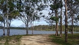
Recreation
Located on the picturesque Atherton Tableland, with the Tinaroo Range and the Danbulla State Forest surrounding it, Lake Tinaroo provides a popular tourist attraction and recreation facility for over 500,000 people a year.Water sports
Sailing
Sailing is the propulsion of a vehicle and the control of its movement with large foils called sails. By changing the rigging, rudder, and sometimes the keel or centre board, a sailor manages the force of the wind on the sails in order to move the boat relative to its surrounding medium and...
, water skiing
Water skiing
thumb|right|A slalom skier making a turn on a slalom waterski.Waterskiing is a sport where an individual is pulled behind a boat or a cable ski installation on a body of water, skimming the surface.-History:...
, houseboating and swimming. During the drought of the last few years, some of the trees that were flooded during the dam's creation have become a hazard to boats because of the receding waters. The park services that maintain the recreational areas of the dam have had to trim the dead trees that have appeared. Thankfully the dam's waters are now higher, so this is no longer a problem.
There are still large areas of flooded vegetation, including trees and other man-made objects such as telephone poles, which stand around in the waters of the Lake. The degree of exposure varying with the water level. As far as I know the policy of the people that control the Lake is that standing timber should remain as fish habitat. There have been a few instances of unauthorised clearing of dead trees in some areas of the Lake.
Hiking
The lake is surrounded by national parkNational park
A national park is a reserve of natural, semi-natural, or developed land that a sovereign state declares or owns. Although individual nations designate their own national parks differently A national park is a reserve of natural, semi-natural, or developed land that a sovereign state declares or...
, rainforest
Rainforest
Rainforests are forests characterized by high rainfall, with definitions based on a minimum normal annual rainfall of 1750-2000 mm...
, pine tree plantations and Australian "bush". Hiking
Hiking
Hiking is an outdoor activity which consists of walking in natural environments, often in mountainous or other scenic terrain. People often hike on hiking trails. It is such a popular activity that there are numerous hiking organizations worldwide. The health benefits of different types of hiking...
paths wind in and out of the mountains surrounding the lake and range from a pleasant walk from the parking lot to the water-front, to week long treks around the lake and its mountains.
Fishing
Many species of fish and other aquatic animals populate the lake. The ever popular barramundiBarramundi
The Barramundi , also known as Asian Seabass, is a species of catadromous fish in family Latidae of order Perciformes. The native species is widely distributed in the Indo-West Pacific region from the Persian Gulf, through Southeast Asia to Papua New Guinea and Northern Australia. Known in Thai...
can grow to an enormous size in the lake because they have no natural predators (except for the occasional speedboat). Each year, the lake is stocked with fresh baby "Barra" from the Walkamin
Walkamin, Queensland
Walkamin is a town on the Atherton Tableland in Far North Queensland, Australia. It is located between Mareeba and Tolga. At the 2006 census, Walkamin and the surrounding area had a population of 630....
Research Station because the fish are unable to breed due to the lack of access to salt water
Seawater
Seawater is water from a sea or ocean. On average, seawater in the world's oceans has a salinity of about 3.5% . This means that every kilogram of seawater has approximately of dissolved salts . The average density of seawater at the ocean surface is 1.025 g/ml...
. Also on the menu at Lake Tinaroo are eel-tailed catfish
Eel-tailed Catfish
The eel-tailed catfish, Tandanus tandanus, is a species of catfish of the family Plotosidae. This fish is also known as dewfish, freshwater catfish, jewfish, and tandan.-Distribution:...
, sooty grunter, sleepy cod
Sleepy cod
The sleepy cod, Oxyeleotris lineolatus, is a medium-sized freshwater fish, native to tropical regions of northern Australia.Sleepy cod generally weigh up to 3 kg. They are very common in waterways across northern Australia. They are plain brown coloured fishes. They are sedentary in nature...
, mouth almighty, archer fish, spangled perch, long tom
Needlefish
Needlefish are piscivorous fishes primarily associated with very shallow marine habitats or the surface of the open sea. Some genera include species found in marine, brackish, and freshwater environments while a few genera are confined to freshwater rivers and streams, including Belonion,...
and many species of crayfish
Crayfish
Crayfish, crawfish, or crawdads – members of the superfamilies Astacoidea and Parastacoidea – are freshwater crustaceans resembling small lobsters, to which they are related...
, including the red-claw
Australian red claw crayfish
Cherax quadricarinatus is an Australian freshwater crayfish.-Distribution and ecology:C...
and yabby
Common yabby
The common yabby, Cherax destructor, is an Australian freshwater crustacean in the Parastacidae family. It is listed as a vulnerable species of crayfish by the World Conservation Union , though the validity of this listing is questionable; wild yabby populations remain strong, and have expanded...
.
A Stocked Impoundment Permit is required to fish in the dam.
Tilapia
Tilapia
Tilapia , is the common name for nearly a hundred species of cichlid fish from the tilapiine cichlid tribe. Tilapia inhabit a variety of fresh water habitats, including shallow streams, ponds, rivers and lakes. Historically, they have been of major importance in artisan fishing in Africa and the...
were illegally introduced into Lake Tinaroo and are now well established. They have been declared a noxious pest species and must be destroyed and buried if caught. It is illegal to possess, rear, sell or buy tilapia. It is also an offence to release tilapia into Queensland waterways or to use them as bait, live or dead. Heavy penalties apply if caught.
Statistics
- Average annual rainfall: 1 300 mm
- Annual yield for irrigation: 205 000 ML
- Assured yield for power generation: 72 000 ML
- Full supply level: 670 m above sea level
- Length of storage: 15 km
- Type of structure: Mass concrete gravity dam
- Height of wall: 45.1 m
- Maximum base width: 35.4 m
- Total crest length: 533.4 m
- Quantity of concrete: 223 000 m³
- Quantity of rock removed for foundations: 153 000 m³
- Spillway type: Ungated, central ogee spillway
- Spillway dimensions: 76.2 x 3.7 m
- Flood inflow (maximum): 256 000 ML/day
- Spillway discharge (maximum): 106 000 ML/day
- Irrigation outlets: 2 x 1 500 mm radial gates
- Barron River outlet: 1 x 1 500 mm cone valve
- Period of construction: 1953 - 1958
- Cost: $12,600,000
Source
See also
- Barron River
- Lake BarrineLake BarrineLake Barrine is a freshwater lake situated on the eastern parts of Atherton Tableland in Far North Queensland, Australia, close to Lake Eacham. The lake and surrounds are protected within the Crater Lakes National Park and are accessible via the Gillies Highway.Lake Barrine was formed over...
- Lake Eacham (Yidyam)
- Mount Hypipamee CraterMount Hypipamee CraterThe Mount Hypipamee Crater, also known as The Crater is a huge diatreme located south-east of Herberton on the Atherton Tableland in Far North Queensland, Australia. It is 61 metres in diameter and 82 metres deep....
- Mount QuincanMount QuincanMount Quincan is a volcanic mountain near Yungaburra on the Atherton Tableland in Far North Queensland, Australia.Quincan, a type of Scoria, is mined from the south west quadrant of the mountain. Quincan is used in road construction, driveways, weed control and domestic gardening.-External links:...
- The Seven SistersSeven Sisters, QueenslandThe Seven Sisters are a series of seven volcanic mounds on the Atherton Tableland, near Yungaburra, Queensland, Australia.-See also:*Lake Barrine*Lake Eacham *Lake Tinaroo*Mount Hypipamee Crater-External links:**...
External links
- Fishing information with lake map at Sweetwater Fishing Lake Tinaroo
- Tinaroo Education Centre