

Mount Hypipamee Crater
Encyclopedia
Diatreme
A diatreme is a breccia-filled volcanic pipe that was formed by a gaseous explosion. Diatremes often breach the surface and produce a tuff cone, a filled relatively shallow crater known as a maar, or other volcanic pipes.- Word origin :...
located south-east of Herberton
Herberton, Queensland
Herberton is a town on the Atherton Tableland in Far North Queensland, Australia. At the 2006 census, Herberton had a population of 974.-History:...
on the Atherton Tableland
Atherton Tableland
The Atherton Tableland is a fertile plateau which is part of the Great Dividing Range in Queensland, Australia. It is located west to south-south-west inland from Cairns, well into the tropics, but its elevated position provides a climate suitable for dairy farming. It has an area of around...
in Far North
Far North Queensland
Far North Queensland, or FNQ, is the northernmost part of the Australian state of Queensland. The region, which contains a large section of the Tropical North Queensland area, stretches from the city of Cairns north to the Torres Strait...
Queensland
Queensland
Queensland is a state of Australia, occupying the north-eastern section of the mainland continent. It is bordered by the Northern Territory, South Australia and New South Wales to the west, south-west and south respectively. To the east, Queensland is bordered by the Coral Sea and Pacific Ocean...
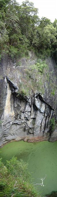
, Australia. It is 61 metres in diameter and 82 metres deep.
It was first discovered by accident when in 1879 Weate and party nearly fell into it. They were heading towards the Mulgrave River
Mulgrave River
The Mulgrave River is a river in Far North Queensland, Australia. It flows in a northerly direction through Gordonvale and the southern outskirts of Cairns, after rising in the Bellenden Ker Range...
on a 5 month gold prospecting
Gold prospecting
Gold prospecting is the act of searching for new gold deposits. Methods used vary with the type of deposit sought and the resources of the prospector...
expedition.
The national park
National park
A national park is a reserve of natural, semi-natural, or developed land that a sovereign state declares or owns. Although individual nations designate their own national parks differently A national park is a reserve of natural, semi-natural, or developed land that a sovereign state declares or...
was established in 1908 under the sponsorship of Mr Ringrose of Herberton. There was a debate at the “crater trust” meetings during the 1930s as to what to call “the crater”, the "Herberton Crater" was one suggestion but it was decided to call it the traditional Dyrbal name, Mount Hypipamee. A request was written to the Reverend Gribble of Palm Island
Palm Island
Palm Island may refer to:* Palm Island, Queensland, Australia, the community on Great Palm Island* Great Palm Island, Queensland, Australia, the island* Palm Island, Grenadines...
to find the origin of the name. The name Hypipamee is a corruption of the Aboriginal
Australian Aborigines
Australian Aborigines , also called Aboriginal Australians, from the latin ab originem , are people who are indigenous to most of the Australian continentthat is, to mainland Australia and the island of Tasmania...
word, nabbanabbamee, which is connected with a legend of two young men who cut down a sacred candlenut tree, only to be swallowed up by a large hole in the earth the crater.
The water surface is covered with duck weed. Visitors often throw rocks down into the water to hear the loud bang when the rock hits the surface of the water and the noise echos up the sides. Dinner Falls
Dinner Falls
Dinner Falls is a waterfall on the upper Barron River in Far North Queensland, Australia.The waterfall is located south of Atherton on the Atherton Tableland near the Mount Hypipamee Crater in...
at the head of the upper Barron River
Barron River (Queensland)
The Barron River is located on the Atherton Tableland inland from Cairns in Northern Queensland, Australia. With its headwater at Lake Tinaroo, it is more than 165 km long and has a catchment area of approximately 2138 km².-History:...
gorge is also part of this park.
It was once thought that "The Crater", Lake Eacham
Lake Eacham
Lake Eacham: is a popular lake of volcanic origin on the Atherton Tableland of Queensland, Australia, within the World Heritage listed Wet Tropics of Queensland.-Origins:...
and Lake Barrine
Lake Barrine
Lake Barrine is a freshwater lake situated on the eastern parts of Atherton Tableland in Far North Queensland, Australia, close to Lake Eacham. The lake and surrounds are protected within the Crater Lakes National Park and are accessible via the Gillies Highway.Lake Barrine was formed over...
were all connected underground with water tunnels, but this is incorrect. Local legend once said that an aboriginal woman once fell over the side into the crater and later surfaced in Lake Eacham.