
Lake Sélingué
Encyclopedia
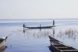
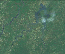
Lake Sélingué is a 409 km² artificial lake in Mali
's Koulikoro Region
, formed by the Sélingué Hydroelectric dam
on the Sankarani River
. Its southwestern arm forms part of the border with Guinea
. Lake Sélingué, rising and falling in the rainy and dry seasons, allows agriculture
on the irrigated perimeters, managed by the Office of Rural Development of Sélingué, as well as fishing. Since its creation, numerous communities have grown along the lake, the two largest being the towns of La Carrière and Faraba
. Fishing the lake provides employment for more than 8,000 people in its various fishing communities, with an annual catch of around 4,000 tonnes. Most fish available in Bamako
come from Lake Selingue.
 Selingue is Mali's second largest artificial lake (reservoir
) after Lake Manantali
, created by the construction of the Manantali dam
in 1988.
Mali
Mali , officially the Republic of Mali , is a landlocked country in Western Africa. Mali borders Algeria on the north, Niger on the east, Burkina Faso and the Côte d'Ivoire on the south, Guinea on the south-west, and Senegal and Mauritania on the west. Its size is just over 1,240,000 km² with...
's Koulikoro Region
Koulikoro Region
Koulikoro is a region in Mali. It is the second administrative area of Mali and covers an area of 90,120 km². Its capital is the city of Koulikoro.- Geography :...
, formed by the Sélingué Hydroelectric dam
Selingue Dam
The Sélingué Dam is a single purpose hydroelectric dam located in the Koulikoro Region, on the Sankarani River, one of the affluents of the Niger River...
on the Sankarani River
Sankarani River
The Sankarani River is a tributary of the Niger River Flowing northward from the Fouta Djallon highlands of Guinea, it crosses into southern Mali, where it joins the Niger approximately 40 km upstream of Bamako...
. Its southwestern arm forms part of the border with Guinea
Guinea
Guinea , officially the Republic of Guinea , is a country in West Africa. Formerly known as French Guinea , it is today sometimes called Guinea-Conakry to distinguish it from its neighbour Guinea-Bissau. Guinea is divided into eight administrative regions and subdivided into thirty-three prefectures...
. Lake Sélingué, rising and falling in the rainy and dry seasons, allows agriculture
Agriculture
Agriculture is the cultivation of animals, plants, fungi and other life forms for food, fiber, and other products used to sustain life. Agriculture was the key implement in the rise of sedentary human civilization, whereby farming of domesticated species created food surpluses that nurtured the...
on the irrigated perimeters, managed by the Office of Rural Development of Sélingué, as well as fishing. Since its creation, numerous communities have grown along the lake, the two largest being the towns of La Carrière and Faraba
Faraba
Faraba is a small town and commune in the Cercle of Kéniéba in the Kayes Region of south-western Mali. As of 1998 the commune had a population of 4974....
. Fishing the lake provides employment for more than 8,000 people in its various fishing communities, with an annual catch of around 4,000 tonnes. Most fish available in Bamako
Bamako
Bamako is the capital of Mali and its largest city with a population of 1.8 million . Currently, it is estimated to be the fastest growing city in Africa and sixth fastest in the world...
come from Lake Selingue.
Reservoir
A reservoir , artificial lake or dam is used to store water.Reservoirs may be created in river valleys by the construction of a dam or may be built by excavation in the ground or by conventional construction techniques such as brickwork or cast concrete.The term reservoir may also be used to...
) after Lake Manantali
Lake Manantali
Lake Manantali is a large artificial lake, formed by the 1989 construction of the Manantali Dam, on the Bafing River in Mali. Its northern point is located 90 km to the south-east of the city of Bafoulabé.-Size:...
, created by the construction of the Manantali dam
Manantali Dam
The Manantali Dam is a multi-purpose dam on the Bafing river in the Senegal River basin, 90 km to the south-east of Bafoulabé, in Mali's Kayes Region.-History:...
in 1988.